Showing posts sorted by date for query "02/06/2008". Sort by relevance Show all posts

Friday, December 19, 2008

End of the road: the Mull of Galloway tide race.


After we reloaded the kayaks onto the car, we drove to the road end at the Mull of Galloway, the southernmost tip of Scotland.
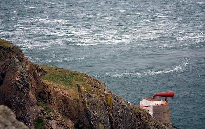

Looking east on the spring ebb tide you can see the main race comes very close to the east end of the Mull but it then heads SW, out to sea, leaving most of the cliffs below the Mull standing in a relatively flat eddy.


This is the spring ebb race running against a force 4 to 6 SW wind.


Looking south towards the Isle of Man over the ebb race.


Looking west, the ebb race is well offshore...but the water round Gallie Craig is not exactly flat.


To give an idea of the scale this is Gallie Craig from the sea looking east towards the lighthouse! (17/02/2008)


The above photos show the ebb race. The flood race come much closer to the cliffs than the ebb. We went through against the flood tide, 2 hours from slack water at springs. This photo (in a similar wind to that which we experienced) shows the water state below the fog horn, 2 hours from slack water at neaps. It gives an idea of what we met. We found more broken water and the conditions persisted without a break for 2km! To give some idea of scale, the photo was taken from a height of 71m. (28/12/06)


Going east to west, on the west going ebb you have only a short 100m or so of race to cross at the east end of the Mull. After this you enter a large relatively flat eddy which extends right to the west end of the Mull and beyond.

Going east to west on an east going flood as we did, even in close to the rocks, you are much closer to the main race. From the light house you have to fight adverse currents at each headland. The red arrow highlights a submarine reef which throws up standing waves especially on the flood.

What a fun place! No wonder several legends attach to this place.....

PS Of course most people would have driven up to the road end at the top of the cliffs and looked at the race before they paddled it. Many would have decided that one look was enough! The trick with this type of paddling is not to look first! We didn't, but of course I am not recommending this ostrich type of approach to planning sea kayaking expeditions! In truth I knew exactly what it would look like as I have gazed down on the race in many different conditions but not paddled it afterwards.

15/12/2008

Tuesday, October 07, 2008

Dun roamin', the return to Hirta.


Emerging from the Great Arch of Dun for the last time, we headed for Village Bay on Hirta. It was 21:30, the end of a fantastic day.


As we paddled under the ramparts of Dun, showers of puffins emerged from their burrows and launched themselves over the cliffs to splash into the sea around us. Photo JLW.


Finally we landed on a small sandy beach revealed by the low tide. We had finally circumnavigated Hirta and landed on Village Bay!

02/06/2008
Saturday, October 04, 2008

The great arch of Dun, St Kilda


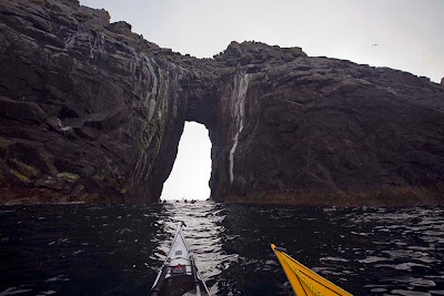
We approached the great arch of Dun from the SW.


We were soon dwarfed by the sheer scale of the place and the tide was running out against us like a salty river.


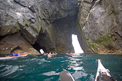
Then as we entered the main portal we saw there were two exits to Village Bay. We chose the smaller one.


On exiting into the shelter of Village Bay we could have just headed for the Cuma and a hot shower. Instead we turned to the SE and rounded Gob an Duin, the most easterly point on Dun. Sadly I have no photographs as the wind against tide meant the point was quite lively. We then proceed up the coast of Dun and re-entered the SW portal of the great arch.


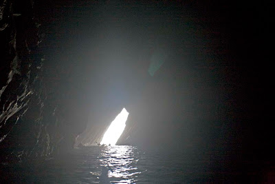
This was looking back through the NE portal as the others came through after me.


The flow of the tide had built up rather quicklysince our first transit of the arch....


and I was soon rejoining the others inside the arch again.

02/06/2008

Wednesday, October 01, 2008

The south west coast of Dun, St Kilda archipelago.


We emerged from the darkness and enclosure of the caves of Dun and found ourselves once more with the empty Atlantic horizon to the south west.


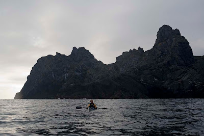
We paddled under Dun's sheer cliffs and made for the stack of Sgeir Cul an Rudha.


Above us thickening cirrus clouds announced the arrival of a front and the promise of wind by morning.


We were still in awe of the sheer scale of the rock architecture of these islands.


Squalls of wind gusted between the stack and Dun.


We rounded the great headland of Giumachsgor and there before us, lay the portal of the Great Arch of Dun!

02/06/2008

Tuesday, September 30, 2008

The Riddle of Dun: subterranean sea kayaking!


We emerged from the cave on the Hirta side of the Dun Gap in the St Kilda archipelago. Our eyes adjusted to the light and now focussed on Hirta's smaller neighbour, the island of Dun.


We made good progress down the NE coast of Dun. The isolated stack of Levenish lay far out on the horizon. "This won't take long" we thought. The time was now 8pm, well past our dining hour.


Then Murty showed us the most amazing series of caves.


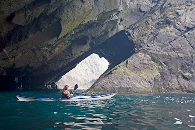
Each cave linked to another and we soon lost all sense of direction and time as we threaded our way through the maze of caverns.


This is probably the most amazing marine cave system in the British Isles!


It has been created by some of the most violent seas that hit the Britain's coasts.


We were so incredibly lucky to be here on a day which was calm enough to allow us to enter.


All thoughts of our evening meal were forgotten.


Each of us was lost in our thoughts as we drifted silently through the caves and arches in awe of nature's creation.


Eventually we emerged on the SW side of Dun, now knowing that it is an island riddled with caves.


02/06/2008

Tuesday, September 23, 2008

The Dun gap, St Kilda


As we neared the end of our circumnavigation of Hirta we entered the narrow Dun gap which separates Hirta from its near neighbour Dun. Many sea kayaking trips never have the opportunity to go through here due to the huge swells which normally drive relentlessly through the gap. We were indeed privileged.


Once we were under the cliffs of Dun we could see the stack of Giasgeir with the hill of Oiseval, 293m, which forms the far side of Village Bay. A male eider duck came flying through at high speed.


Eiders are Britain's largest ducks. And are sometimes called "Whoo Whoo" birds on account of their mating calls in late winter and early spring.


As we emerged from the gap we turned sharp left before Giasgeir.


Murty knew of a large cave that led to a tunnel that would take us out into Village Bay on the far side. Sea kayaking doesn't get much better than this.

02/06/2008

The great cave of Rubha Mhuirich, St Kilda


Continuing our circumnavigation of Hirta in the St Kilda archipelago, we came across the great cave of Rubha Mhuirich.


This huge cave is about 100m deep running straight into the cliffs. The MV Cuma was dwarfed by its scale


The light extended right to the back of the cave where there was a sandy beach. We could not land because of the amplification of the swells in the narrowing walls. One can only imagine the force of the ocean's fury in an Atlantic storm!

02/06/2008

Monday, September 08, 2008

Sea Kayakphoto.com trip index 2008

I have been posting little snippets of various trips concurrently. For those who would like to follow the thread of a single trip, I hope this index will be useful.

Less is more round Lismore!
27/12/08

What a carry on round the Mull!
15/12/08 The Mull of Galloway

Another West coast sunset! Firth of Clyde
14/12/08 Bute from Portencross,

Dunure from Maidens, Firth of Clyde
06/12/08

The Four Castles of Carrick, Firth of Clyde.
02/11/08 Turnberry to Ayr

The River Fleet from Fleet Bay
17/10/08

Loch nan Ceall and the Sound of Arisaig
13/09/08
14/09/08

To the Corryvreckan
30/08/08 Seil to Scarba via the Corryvreckan
31/08/08 Scarba to Seil via the Grey Dogs and the Cuan Sound

The Mull of Kintyre
26/07/08 Macrihanish to Sanda via the Mull
27/07/08 Sanda to Davaar Island

To Islay
12/07/08 Claggain Bay
13/07/08 Traigh Bhan
14/07/08 An Claddach
15/07/08 Port Askaig

To St Kilda
30/05/08 Loch Roag
31/05/08 Taransay
01/06/08 Monach Islands
02/06/08 Hirta and Dun
03/06/08 am Village Bay, Hirta
03/06/08 pm Boreray and the stacks
04/06/08 Loch Reasort to Scarp
05/06/08 Pabaigh Mor and Bhacsaigh

To the Garvellachs
10/05/08 Seil to the Grey Dogs via the Corryvreckan
11/05/08 Grey Dogs to the Garvellachs and Seil

Lady Isle
08/05/08 A busy night at Troon

Ailsa Craig
05/05/08 Gannets and granite

Fleet Bay
02/05/08 Solway sunshine

A misty Firth of Clyde
27/04/08 Maidens to Ayr

Arran
18/03/08 Portencross to Brodick via the Wee Cumbrae, Bute and Glen Sannox

Mull of Galloway
17/02/08 Ardwell Bay to East Tarbet

Dorus Mor
12/02/08 Craignish through the Dorus Mor to Crinan and Loch Craignish then back through the Dorus Mor as the sun set.

The four maritime castles of Carrick
20/01/08 Turnberry to Ayr.

The Cumbraes and Bute
12/01/2008 A day trip in the Clyde from Largs

The west coast of Hirta in the St. Kilda Archipelago


We emerged from the threatening darkness of the Hirta/Soay gap and made our way south down the west coast of Hirta.


Looking back to the north, Soay was still wreathed in its cap of cloud.


The cliffs on this side of Hirta were no less impressive than on its north side.


From the summit of Mullach Bi (358m) the great headland of Carn Mor plunges into the sea.As we approached we thought we could see light coming through what appeared to be a cave.


It turned out to be a long tunnel which made its way right through the headland from the west to the south coast of Hirta. It is called Geo Creag an Arpaid and we were lucky enough to be there when it was calm enough to paddle right through!

02/06/2008

Friday, July 11, 2008

Sea Kayaking through the gates of Hell!


The Cuma reported a force 4 to 5 SW wind on the far side of the Hirta / Soay gap.


As we went down the west side of Stac Soay, the gap between it and Stac Biorach looked like the gates of Hell!


Fortunately we did not need to pass through to Hades as a tunnel appeared leading right through to the other side of Stac Soay.

02/06/2008

Unfortunately there will now be a short intermission. The staff of seakayakphoto come are headed for the fair isle of Islay. We have heard tales of many shore side distilleries, with magical names like Bruichladdich, Bowmore, Laphroaig, Lagavulin, Ardbeg, Caol Ila and Bunnahabhain.

We may be gone for some time.......