Imagine you are at the edge of the sea on a day when it is difficult to say where the land ends and the sea begins and where the sea ends and the sky begins. Sea kayaking lets you explore these and your own boundaries and broadens your horizons. Sea kayaking is the new mountaineering.
Showing posts with label Mountain biking. Show all posts
Monday, October 06, 2008
Lonely Loch Einich
As we made our way further up Gleann Einich we came across the Alt Ruigh na Sroine, the first of many streams to ford.
Later on the Beanaidh Bheag river was to prove far tougher and necessitated a change of socks.
As we gained height the mountain landscape became more dramatic.
Under wild skies the granite ridges were dusted with the first snows of winter.
The air was filled with the sound of burns tumbling down from high corries and rattling the boulders in their beds.
At last we breasted a moraine and below us lay lonely Loch Einich.
We were dwarfed by the scale of the landscape.
Loch Einich lies at a height of 598m. It is seldom visited, even in summer. On the 9th of September this year, Rothiemurchus Estate's head stalker, Peter Ferguson made a very sad discovery. He found a dead body inside a tent which had obviously been pitched for several weeks. The man had been a writer and photographer. I hope his death was peaceful as he was so far away from help and his family.
We started the long descent to Glen More as the clouds lowered from the high corries.
In the valleys it was still autumn and bright October sunshine had yet to give way to winter.
This little lochan reflected the beauty and tranquility of this wonderful place. By 16:30 we were a world away, back in Glasgow.
05/08/2008
Sunday, October 05, 2008
Gleann Einich in the Cairngorms by mountain bike.
Over the last 10 days I have sea-kayaked, windsurfed and mountain biked across Scotland from Galloway to the Grampians (using a car to get from location to location). It has been a fantastic outdoor experience.
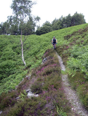
Today we mountain biked deep into the heart of the Cairngorm mountains making our way to high ground through stands of the ancient Caledonian forest.
It is a high plateau with deep glacial valleys radiating out from its heart.
We made our way into the depths of Gleann Einich which is overlooked by the jagged ramparts of Sgoran Dubh Mor, 1,111m.
Magnificent!
05/10/2008
Wednesday, April 23, 2008
Remnants of Scotland's ancient forests of oak.
This view, of Beinn Sgritheall from Loch Hourn, is most people's idea of the scenery of Scotland: a wild landscape of bare mountains tumbling into deep sea lochs. It is, however, not natural. It is man made and is a result of deforestation. After the retreat of the last ice age, a beautiful sessile oak forest grew on much of the western sea board of Scotland. It was cut down over the centuries to clear the land for agriculture, to build ships, provide charcoal for the iron industry and tannin for the leather industry.
There are a few surviving pockets of the natural oak forest such as this one at the head of Glen Trool in Galloway.
The forest floor is carpeted with mosses, lichens, ferns and holly.
Another surviving pocket is on the north shore of Fleet Bay on the Solway Firth. Here the oaks grow right down to near the high water mark.
The great western sessile oak forest of Scotland must have been indescribably beautiful.
Wednesday, April 16, 2008
The mystery of the first of the seven stanes.
On the watershed between Glen Trool and the Dee valley we crested a hill and paused to take in the view of Loch Dee. Rory, the Border terrier, spotted something in the heather.
It was an amazing giant's axe head, carved out of granite and highly polished. Rory looked perfectly at home, in this, his natural environment.
Its surface was inscribed by runic symbols. It was peaceful to sit there, surrounded by the Galloway hills, glens and lochs, wondering what it meant.
It is one of seven stanes. Each is located in one of Southern Scotland's 7 Stanes mountain bike areas.
13/04/2008
Monday, April 14, 2008
The hill tracks of Galloway and the harvest of the sea
From a distance it looks like the hill tracks of Galloway have a dusting of snow.
But as you walk or ride on the tracks, the crunch of this white covering is like no snow.
It is composed of tons of scallop shells which are a by product of the Kirkcudbright scallop fishing industry. There is no more space to dump them at the back of local farmers' fields, so they are now brought up here and dumped on the hill tracks. As the shells break down, the calcium carbonate might do something to reduce the effects of acid rain which has damaged the Galloway hill lochs.
Seeing the sheer number of scallop shells scattered on these hills, you realize just how big the scallop industry is. I know the Irish Sea is a big place but I do hope this proves to be a sustainable fishery.
13/04/2008
The following is an extract from SEPA View, issue 17 Autumn 2003 the magazine of the Scottish Environmental Protection Agency.
Evaluate use of waste scallop shells as road dressing to improve acidity in watercourses
Manager: Stuart Coy
Of 500km of fishless waters in Scotland, Galloway has 400km. Much of this relates to the extensive forest coverage in the area, which exacerbates acid rain. The trees filter out the acid and concentrate it, so when it rains the acidified water runs into the nearby watercourses. In many countries, lime has been successfully used to counteract acidity either by direct addition to water or application over the catchment land. However, this is an expensive and perhaps unsustainable procedure. As scallop shells are 95 per cent limestone in composition and the country’s largest processor of waste scallop shells, West Coast Sea Products, is situated in Galloway, an action plan was established to determine whether the shells could be used as a viable means of reducing levels of acidity in local watercourses. As waste, the shells must be disposed of in a manner that conforms with the exemptions laid out in the Waste Management Licensing Regulations 1994 which permits them to be used in road construction. Two methods are currently being employed. In the first, clean, crushed shells are incorporated into the sub-base aggregates, effectively burying them. The second, more appropriate use, is as a road surface dressing. In theory, the passage of vehicles will speed up the release of calcium.
SEPA Galloway team leader, Stuart Coy said: “This experimental use of shells is still very new to Galloway and the logistics of getting them from the factory to the forest in an acceptable condition are continuing to develop. If it can be made to work then it seems there will be benefits all round. “Should there be a reduction in the quarried aggregate required for road construction, the use of the shells in this way means that they will not be going to licensed landfill which would have cost around £100,000 for disposal. Ultimately, much-needed calcium will be released into acidified surface waters.”
Sunday, April 13, 2008
The Merrick and the Galloway hills.
A mountain bike is a great way to get round the Galloway Hills in SW Scotland. The Merrick is the highest hill on the Scottish mainland south of Ben Lomond. Its summit is still iced in the last of the winter snows.
Starting from the car park at the Bruce's stone above Loch Trool, we covered 28km and 900 metres of ascent and decent.
13/04/2008
Thursday, December 20, 2007
Galloway lanes and a bridge too far.
Last Sunday it was a bit windy, cold and rough for sea kayaking so Tony and continued our fitness regime by cycling along some Galloway lanes in the Galloway Hills near Loch Doon.
There was quite a lot of rough stuff to negotiate. We did 15km and 360m of ascent and descent and passed hills with wonderful names like Craigmawhannel and Coran of Portmark.
I first biked across this bridge in 1988. I told Tony it was all right then. Unfortunately it was not all right on Sunday. It had been carried away by a winter flood and its two ends were very much attached to the same piece of dry land with not a trace of even damp beneath its timbers. This was now only a bridge by name, its basic function was no more. In truth it had much in common with the Monty Python parrot.
There was another catch. In Galloway a lane is not some quiet country byway along which one can enjoy a gentle Sunday afternoon peddle. It is a deep, often slow moving, river which has cut down through the peat to the granite bed rock up to 12 feet below. We had an interesting dilemma. Should we risk falling into the icy water or turn back through miles of bog and hill? Fortunately the bridge had been built on the site of an ancient crossing and there were some slippy green stepping stones, which we gingerly balanced across. Tony's dog, Bob, was big enough to swim across...but Rory, the border terrier, was too small and so I carried him over.
Otherwise, Rory was well suited to the environment by being tough enough to keep up with us and being perfectly camouflaged. Unfortunately he saw no squirrels (grey).
Here he is near the end of the route on the shore of Loch Doon.
15/12/2007
Wednesday, December 12, 2007
A tale of lamb chops, coal, caesium, sand, fog, wind mills, government and the environment.
One of my favourite launch spots on the Solway Firth is Dhoon shore on Goat Well Bay. Today I learned from BBC News that SEPA (Scottish Environmental Protection Agency) are investigating the sands for any evidence of radioactive contamination from the Sellafield nuclear plant on the other side of the Solway.
I have no strong feelings against nuclear power but I do expect the operators to run a tight ship and there have been lots of careless lapses both in the UK and elsewhere. There are areas of the Ayrshire and Galloway hills (north of the Solway) where sheep and lambs are still not fit for human consumption due to radioactive caesium fall out from the Chernobyl disaster in 1986.
Elsewhere today, 5,000 Shetland sheep have been slaughtered and buried. They were intended for export to England in the autumn for lamb chops but a government research lab leaked foot and mouth virus. The resulting restrictions on animal movement meant they had to stay on Shetland and now there is no pasture left to feed them.
Now it is not sheep but the wind that is farmed in these hills. Despite the government's recent enthusiasm for wind turbines (and there is a huge offshore development currently being constructed in the Solway) I cannot see that these will meet all our energy needs. Monday dawned in Scotland under clear cold and windless skies.
Cycling through the wind farm in the foggy but clean air of Sunday brought back memories of the smogs of the 1950's caused by burning coal for our energy needs. Of course all the cheap Chinese manufactured goods that are flooding into western Christmas stockings have been made by burning coal but that's on the other side of the world. Isn't it?
Sunday, December 09, 2007
Wind turbines on Windy Standard
The weather has not been particularly conducive to sea paddling this weekend so Tony and I decided to go for a little bike run in Galloway instead. We planned to cycle over Windy Standard, a 698m hill in the Carsphairn Forest.
The clear sky of the morning gave way to mist and sleety rain. As we climbed through the clouds we heard a "whoosh whoosh whoosh" long before we saw the wind farm. It was quite surreal cycling along at above 600m in height with 36 turbines all round us. Windy Standard currently generates up to 21.6 megawatts but another 30 turbines are planned. My legs could have done with some of that power.
We got up to 685m which was above the snowline. Bob the dog had never seen snow before.
We needed to stop for a breather, below the cloud line, after a white knuckle descent.
We did 31km and ascended a total of 940m in just under 4 hours. I was quite pleased with that!
Sunday, November 25, 2007
Mountain biking Glen Trool Blue route and Bennan
The summit of wind swept Bennan in the Galloway Hills.
Jennifer with Bennan disappearing into the mist.
We have recently visited the Glen Trool Blue route a couple of times to increase our cardiovascular fitness and stamina to cope with winter paddling conditions in Scotland. The Blue route has some fantastic berms on its final decent and is certainly not blue at the speed we go down it. However, it is only 8km long, so on our first visit we went round it twice.
Today we decided to tack the gruelling ascent of Bennan (562m) on to make it a little longer.
Mike, Jennifer, Tony and Bob on the way up. The way back down to the blue route passed in a blur.
We rejoined the blue route for its final decent.
Glen Trool is down there in the mist.
One fantastic berm after another leads to...
...a final blast through a larch plantation.
19 km and 688m of ascent.
We deserved a pint of Guinness in the Black Bull (est 1766), Straiton on the way home. In case you think we have undone all the goodness of the exercise, here is a fascinating scientific fact which I gleaned from television last night. Imagine four pint glasses on a bar. The first is filled with milk, the second with freshly squeezed orange juice, the third with lager and the last with Guinness. Which one has fewest calories?
Well it's the Guinness of course. It's a health drink!
25/11/2007
04/11/2007