Showing posts with label beaches. Show all posts

Friday, March 18, 2022

The Beaches of Scotland by Dr Stacey McGowan Holloway: Book Review

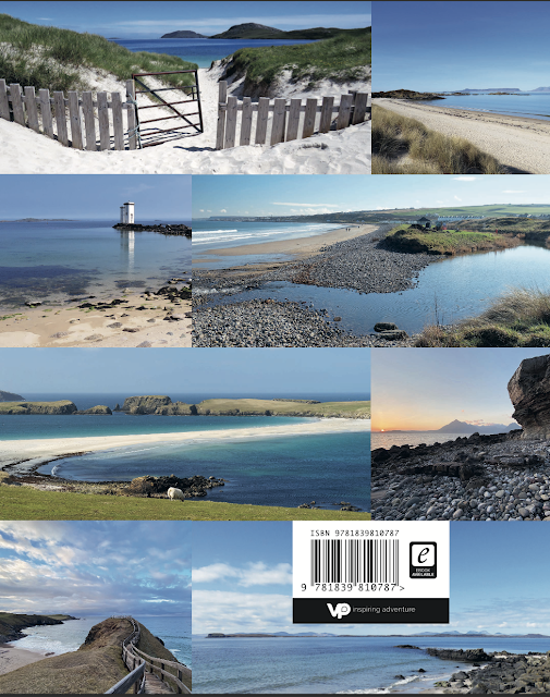
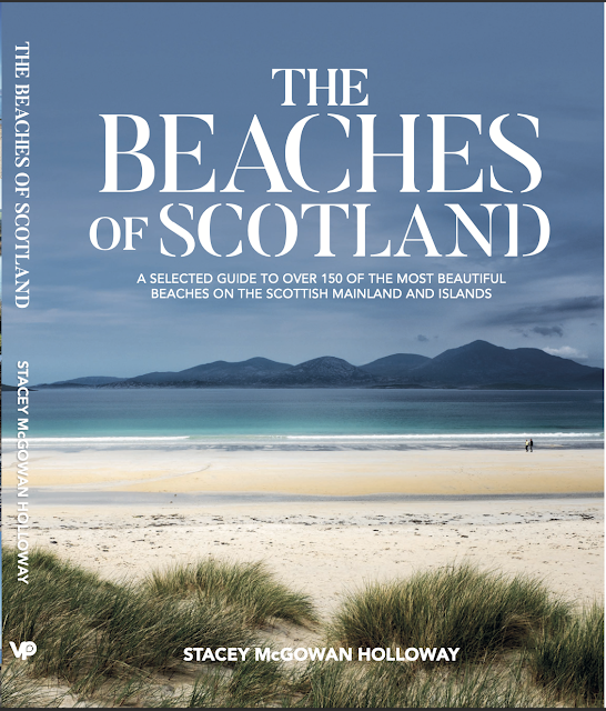
This beautiful book is an illustrated  guide to over 150 beaches scattered round the 19,000 km coast line of the Scottish mainland, the Hebrides and the Northern Isles. 

I particularly liked the introduction in which the author discusses beach safety, how to visit (responsible access), types of beach, seascape and geology (contributed by the author’s husband who is an oceanographer), how and when to travel (this includes valuable advice for those who choose to travel by car or camper van rather than by foot, cycle or public transport). I especially liked why the author has chosen the beaches included in the book. 

“The reasons for a beach being chosen for this book were multifactorial, based on its beauty, uniqueness, location and importantly whether it has the infrastructure in place to sustain tourism.” 

I applaud the author for this approach. Several of my favourite beaches are not in this book and I am pretty sure the author knows them well. However, each has some sort of issue that would be exacerbated by a significant increase in visitor numbers, such as threat to wildlife habitat or access problems including car parking and serious erosion of access paths. This approach might be considered by some as elitist but the publication of a recent guide to mountain bothies has already resulted in the closure of two bothies as a result of overuse and indiscriminate parking.  Another example of attracting too many people to a limited natural resource is the Fairy Pools in the Skye Cuillin which have now been well and truly "Instagrammed". In contrast, this book will disperse visitors over a very wide area.  In doing so, it serves as a wonderful introduction to Scottish beaches and leaves the visitor the joy of exploration and discovery of “new” beaches in each area.

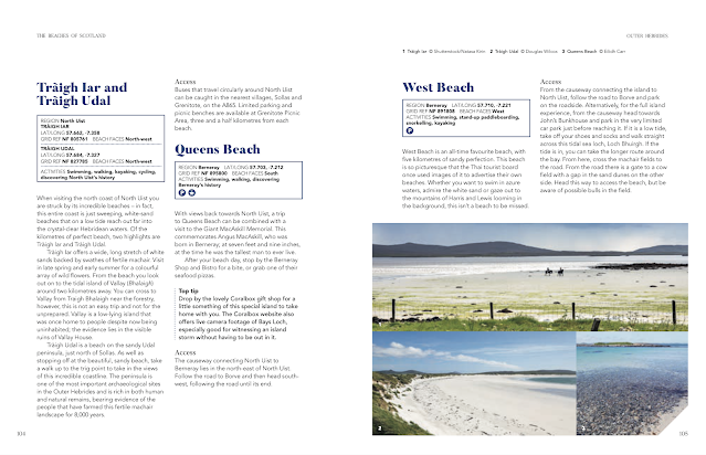
Each beach is illustrated with a photo and descriptive text. There are also key facts including access, toilets and activities. In a guide like this there is not enough room for small scale maps of individual beaches so, for many of the less accessible beaches, an OS map will be useful and the key facts include Lat/Long co-ordinates (for GPS input) and OS map grid references. There are large scale maps showing the location of multiple beaches, which will be invaluable when planning a trip to an area.

This book will have wide appeal to walkers, swimmers, cyclists, kayakers and paddle boarders. I recommend it thoroughly.

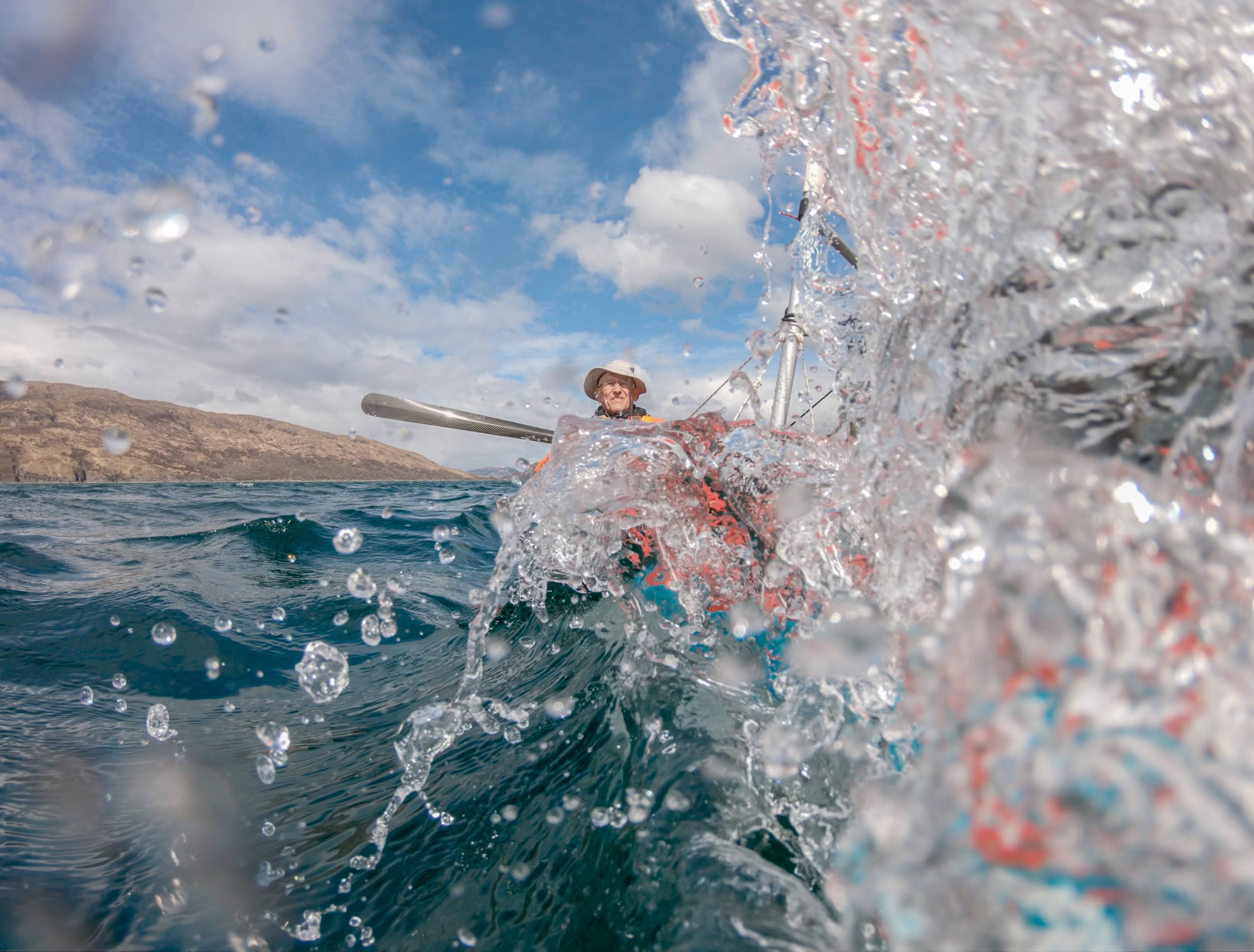
PS I have contributed a photo of one of the remoter beaches in the book. The publisher contacted a friend, who is an accomplished photographer and author of guidebooks to see if he had a photo of this beach. His reply was “If anyone randomly has a photo of an obscure and remote 1km-long beach in the Western Isles sitting on his hard drive, it’ll be him…” I guess that qualifies me to both review the book and comment on the choice of included beaches.

The Beaches of Scotland, Dr Stacey McGowan Holloway, Vertebrate Publishing, publication date 7/4/2022, ISBN 978183981078


Friday, July 02, 2021

29th April 2021 #7 Locked in but not locked down by a wild night in Loch Hourn.


Ian and I set to work building a fire on the shore of Loch Hourn. We chose a site below the highest tide level but, as it was just before predicted HW, we expected the tide not reach the fire.

A stiff NE breeze soon had it burning fiercely.

Unfortunately the tide kept rising and we had to rescue the wood and leave the fire to the mercy of the water. We built a new fire further up the shore.

Of course the sun did not stay out long. Yet another squall battered down the loch towards us obliterating the view of the mountains as it came. A brave rainbow framed the scene but lasted only a few seconds till it was lost in a wall of grey. The approaching storm was elemental and truly magnificent. For a while we were transfixed by its beauty but just in time, we abandoned the new fire to its own devices and fled to the tents. The noise as the wind ripped at the flysheet and alternate bands of rain and hail lashed down added to the sense of wildness.

After the storm, we emerged from the tents to find a dusting of fresh snow on the summits but more importantly the wind had dropped.

As the sun began to set on this landlocked arm of the sea...

... its still waters reflected the sunset colours of the clouds, despite the setting sun being hidden below dark enclosing mountain ridges.

As night fell and the fire burned more brightly we swapped tales of kayaking adventures. We might be locked in, in inner Loch Hourn, but we were no longer locked down!

Monday, May 24, 2021

29th april 2021 #2 Crossing the deep at the mouth of Loch Hourn.

From Camusfearna we followed the pine covered rocky coast of the Glenelg peninsula south until we came to the entrance of Loch Hourn.

This sea loch stretches deep into the mountains for 22km from its mouth on the Sound of Sleat. 

We set off across its entrance for the south shore while my brother in his little RIB "The Guppy" motored slowly up the north shore so as not to disturb us.

The NE wind dropped in the lee of Beinn Sgritheall, 974m, as we passed the halfway point at a shallow reef marked by a pole; Sgeir Ulibhe or Wolf Rock. Don't be fooled by the apparent shallow water, just to the south of the rock, the glacial trench that forms Loch Hourn is 189m deep. That is deeper than the Atlantic Ocean until about 100km west of the Outer Hebrides!

As we cleared the Glenelg peninsula, a magnificent view of the rocky Skye Cuillin ridge opened up to the WNW.

By the time we had crossed the mouth of Loch Hourn and...

...reached its Knoydart shore, it was well past time for second breakfast.


Saturday, May 22, 2021

28th April 2021 #2 Sunshine and sleet on the Sound of Sleat.


It has been a cold start to the year and the NE wind brought a series of Arctic squalls to the Sound of Sleat. These brought a bonus of dramatic lighting conditions though trying to erect our tents on the exposed reef took a bit of care in the accompanying wind.

Fortunately the worst of the squalls seemed to pass and we got our camp in order.

As the tide was still low...

...we wasted no time in gathering driftwood for a fire on the sands. We kept our kayaking gear on as the sun did not look like it would last long.

Then the skies darkened with the approach of yet another squall. We rushed to our tents and were deafened by alternate lashings of rain and sleet on the thin tent walls.

As the storm passed, on its way into Loch Hourn, we emerged from our tents into the watery evening sunlight.

Graceful rainbows arched over the still dark mountains, which had a dusting of fresh snow  on their summits.

Hardy primroses seemed undeterred by the weather and neither were we.

We set to and got the fire going as we swapped yarns and...

...finished our meal.

A watery sunset slipped away on the far side of the Sound of Sleat before another squall put an end to our evening by the fire.

Friday, May 07, 2021

28th April 2021 #1 Return to sea kayak camping, a trip to the Sound of Sleat and Loch Hourn.

Due to various health problems I have not posted much here recently mainly because I have not gone anywhere. However, I managed to get myself north to Glenelg on 28/4/2021 to join Ian from Mountain and Sea Scotland and friends. It is the furthest I have driven, furthest I have paddled and the most nights I have camped out in over 4 years.

I get easily tired these days and though previously I have driven to Loch Hourn, paddled and driven back in a day, I now stop every hour. I left Glasgow at 6am and my first stop was at the Falls of Falloch north of Loch Lomond.

My second stop was under the Three Sisters of Glencoe where 

the Alt Lairige Eilde tumbles into the glen over a series of three waterfalls. I also stopped at the Spean Bridge Commando Monument but there was no view to Ben Nevis due to fog. A further stop at the Loch Garry viewpoint was equally disappointing, due to a large forest having grown up and completely obliterated the view. Goodness knows what tourists make of it.

A final stop near the summit of the Mam Ratagan pass above Loch Duich gave a splendid view to the Five Sisters of Kintail.

Glenelg lay at the foot of the far side of the pass. We had wondered if we would get parked as all the likely spots are usually taken by motor homes. 

Before we left the cars we asked several locals. It turns out the popular Bernara beach was blighted by a few of the many camper vans who visit staying for weeks at a time and dumping sewage onto the beach. The community erected a 2 metre barrier which has kept all camper vans out. That is unfortunate for the responsible owners but was fortunate for us.

Soon we were loaded up and ready to go, though the tide was a long way out as it was spring tides.

My brother Donald came along in his small 2.75m Rib and 6HP outboard... the Guppy. He has made a video of the trip.

Photo Donald Wilcox.

Soon we were on our way with an increasing tail wind.

An RAF Typhoon banked overhead and we could see the pilot looking down on us then

we got a cheery wave from the local prawn boat OB164 MAIREAD M. I hope everyone was happy to see the return of tourists.

The wind quickly picked up and my camera stayed in its dry bag. The GoPro did capture 

some of the sense of freedom after the long winter lockdown.

All too soon it was time to drop the sail and land on our chosen spot for the night, an offshore reef with a white shell sand beach.

It was now spring low water so we had a long carry.

 
The kayak crew were Ian, Allan and his wife Lorna and his brother Raymond. My brother Donald had motored the Guppy round to the lee side of the reef where he would line it in as the tide rose. We were set for our first camp together in quite a few years. Our end of lockdown adventure had begun.

Wednesday, March 14, 2018

A fourth luncheon on the machair at Silver Sands

We stopped on the southern side of the Silver Sands of Smirisary and...

...made our way up the shore to the...

...closely cropped machair which backs the beach. Here, below a rapidly sinking sun, we partook of our 4th luncheon which we washed down with a not ungenerous snifter of 12year old Caol Isla.

After our comestibles had been suitably dwindled, it was time for a...

..post prandial perambulation over the machair to the headland where we took in the view to the Small Isles to the west and...

 ...to Rubh Arisaig and Skye to the north.

 We left Silver Sands and paddled north until we could...

 ...turn to the east and enter the Sound of Arisaig.

The sun was setting as we paddled on towards Glenuig Bay where we drew the boats up in the gathering darkness. Sadly there would be no further luncheons on this day.