Showing posts with label Kilbrannan Sound. Show all posts

Saturday, January 03, 2015

Sea kayaking desktop wallpaper calendar 2015.

Welcome to the 11th annual sea kayaking desktop calendar from seakayakphoto.com! Like 2013, my 2014 has had somewhat restricted paddling. Recovering from several major health problems, caring for my mother in her final illness and then being executor to her estate have all taken their toll on my paddling time. However, what paddling I was able to do was of the finest order and with the best of friends and so quality has made up for quantity. This year all the photos are taken in local waters, all a short drive from home. You can follow the links to Dropbox and download  high resolution photos for your computer or tablet desktop wallpaper in either 4x3 or 8x5 format.

January.
Leaving Portencross Castle before mid winter dawn. Short winter days in Scotland mean an early start and we often launch and land in the dark. From Portencross, we have set off for the islands of the Firth of Clyde: the Great and Little Cumbraes, Bute, Inchmarnock and Arran. Each is a unique adventure.
Link to 8:5 desktop 1920 x 1200.
Link to 4:3 desktop 2048 x 1540.

February.
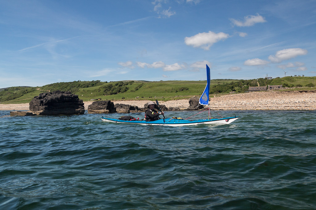
Paddle sailing on a winter crossing to Arran. Our 30km route took us via Garroch Head on Bute then on this fabulous 11 km crossing to Sannox at the north end of Arran. This must be one of the most scenic rossings in Scotland. In winter we arrive in Brodick after sunset then get the ferry back to Ardrossan.
Link to 8:5 desktop 1920 x 1200.
Link to 4:3 desktop 2048 x 1540.

March.
Setting off from the reefs of Lendalfoot on the 14km crossing to the isolated and uninhabited granite island of Ailsa Craig. It lies in an exposed position and the nearest point of land is Lendalfoot. Weather conditions can change rapidly here and we had wind against tide conditions on our return. I capsized while paddle sailing across the Bennane Head tide race about a kilometre offshore. Even though it was sunny and I was back paddle sailing in only a few minutes, I was glad I was wearing a dry suit as the water temperature was only 9C. Anyway it did not put me off returning to Ailsa Craig a further two times (three times in all) in 2014.

April.
We set off across the Kilbrannan Sound from Kintyre to Arran in thick, gloomy fog. It unexpectedly began to clear when we were about 3/4 of the way across. It was like paddling between a day of two halves.
Link to 8:5 desktop 1920 x 1200.

May.
Pinks and plantains at Pladda. The delightful island of Pladda lies off the southern tip of its much larger neighbour Arran. It is protected by swirling tides but with its Stevenson lighthouse and teeming bird life, is a joy to visit. There are so many nesting birds covering the ground (and the lighthouse cottages are a private residence) that it would not be easy to camp there in the nesting season. We usually camp at nearby Kildonan on Arran

June.
The heather growing on Brown Head on Arran means that it is indeed usually brown. However, in early summer, fresh fronds of bracken add a splash of green. The waters are delightfully clear and on this June day warm enough for swimming in a little bay beyond the head. We passed this way twice this year. Once on a clockwise circumnavigation of Arran in March and once en route from Kintyre to Ailsa Craig in June.
July.
Ailsa Craig is a haven for breeding birds the SW and W cliffs soar steeply from the sea and their high ledges are host to tens of thousands of gannets, guillemots, razorbills, kittiwakes and fulmars. Lower down there are colonies of puffins, shags and cormorants. This congregation of cormorants had gathered at Ashydoo Church. No visitor to Ailsa Craig should forget to bring a broad brimmed hat.

August.
Cleats Shore on Arran enjoys some fine views like this one to Ailsa Craig, some 23 km to the SE. It is also one of the few naturist beaches in Scotland. There was no one there on our visit so Ailsa got our full and undivided attention.

September.
We often see the PS Waveley on our travels. She was built in Glasgow in 1947 for the Craigendorran to Arrochar run but was retired in 1974. Since 1975 she has been operated as a tourist attraction and is now the last sea going paddle steamer in the World. We saw her to the north of Arran in the Sound of Bute in the evening calm that followed a very windy and wet paddle up the Kilbrannan Sound. She is one of our larger fellow paddlers!
Link to 8:5 desktop 1920 x 1200.

October.
Back in October I paddled out into Wigtown Bay beyond the Islands of Fleet. The wind steadily dropped to nothing but these strange clouds bubbled up from the Machars peninsula and drifted over distant Burrow Head at the mouth of the Bay.

November.
Paddle sailing is a whole heap of fun. This is going through the tide race off the south end of Pladda. If you only make one sea kayaking resolution in 2015, it should be to give paddle sailing a try!

December.
As the winter sun set behind Great Cumbrae and Arran, Duncan Winning and I enjoyed a long chat about kayaking history. At last we went our separate ways as darkness fell. In 1964 Duncan made the first accurate drawings of the kayak Ken Taylor brought to Scotland in 1960 from Illorsuit in West Greenland. This kayak which was made by Emanuele Korniliussen in 1959 is now in the Kelvingrove museum in Glasgow, Scotland. Duncan's drawings were used to create the Anas Acuta, which was a great influence in what was to become the British style of recreational touring sea kayak.
Link to 4:3 desktop 2048 x 1540.

I wish all readers of seakayakphoto.com a great paddling year in 2015 and thank you for visiting.
Douglas Wilcox.

Monday, September 29, 2014

"Probably the least visited nudist beach in the known universe"

We set off from Brown Head round the SW corner of Arran. All the time Ailsa Craig was growing on the horizon but we did not spend all the time gazing out to sea.

At Corriecravie I thought of all the hard work of my ancestors who were tenant farmers here from at least the early 1700's until the 1930's. The four top fields are still the greenest on Arran!

SE of Corriecravie, the beach consists of basalt dykes...

...rocks below the water and shingle at the HW mark.

As we approached Cleits Shore patches of sand appeared and...

...it looked an ideal spot for third luncheon.

Cleits Shore is one of the few official naturist beaches in Scotland. The book "Bare Britain" describes it thus... "probably the least visited nudist beach in the known universe.". Whatever, it seemed churlish to leave without making full use of the local facilities, as I am sure my ancestors did.

Sunday, September 28, 2014

The clear waters of Brown Head, Arran.

We cut across Drumadoon Bay, which is backed by the village of Blackwaterfoot, and made landfall at...

...Brown Head. The water here was crystal clear but the extensive boulder beach, which lies at the bottom of the headland, extends for 4 kilometres and...

...virtually prevents landing.

However, as it was approaching LW, we found a little strip of sand below the rocks on which to land.

Somehow we had managed to paddle right past this narrow clearing which has been made through the rocks. This was obviously used by our ancestors who wished to launch boats here.

I had spotted an otter as we approached and found this half eaten sea urchin at the edge of the sparkling sea. I went for a swim in the cool clear water then...

 ...dried off in the sun on the grassy machair of a...

...raised beach while Tony went for a walk. The machair was filled with buttercups and would have made a great place to camp but Ailsa Craig (on the horizon) was still some way off and it made sense to carry on round the Arran coast.

Saturday, September 27, 2014

Diverse plans, sills and dykes at Drumadoon.

After leaving King's Cave we paddled sailed south on Arran's remote west coast towards...

 ...the great basalt sill known as The Doon. The flat summit was an extensive Iron Age hill fort.As we passed below basalt columns of The Doon...

 ...towards Drumadoon Point, we caught sight of our destination for the following evening....

 ...Ailsa Craig was still 32km distant.

 There was some tide running round Drumadoon Point but...

 ....to its east the clear green water was calm in Drumadoon Bay where we...

...stopped for first luncheon on a convenient basalt dyke on Blackwaterfoot beach. The dunes above the beach gave some shelter from the rather chilly north wind. There was a little further diversity in the weather forecasts. Some were predicting F2-4 northerly the following day others were predicting F4-5 northerly. We decided to go for Ailsa Craig if it turned out to be the former. At F4-5 northerly the 24 km crossing to Ailsa Craig followed by a 16km crossing to Girvan would be a bit out of our comfort zone so we would head north to Brodick instead. We spent some time texting our plans home and to Phil who hoped to paddle solo out to Ailsa Craig the following day and join us for an overnight camp on the rock.

Thursday, September 25, 2014

Reflections on freedom in the King's Cave Arran.

Tony and I found ourselves on a very rough beach below the King's Cave on the west coast of Arran.

 It is a popular place with walkers and many have built stone towers.

There are a whole series of caves and arches here and we followed a subterranean route to the entrance of...

 ,,,the King's Cave. On this occasion the large gate was not locked and we entered ...

...the cool darkness of the cave.

Once our eyes had adjusted to the lack of light we were able to get right to the back of the cave and...

 ...see some Victorian and...

 ...early Christian graffiti. This is one of the caves in which Robert the Bruce was supposed to have been inspired by a spider during his long struggle to win Scottish Independence. Robert the Bruce was of Norman rather than Scottish ancestry. Nowhere in the cave did I see the initials R de B or indeed a spider! I don't suppose the proletariat had much say in the Scottish Wars of Independence in the late 13th and early 14th centuries.except when their blood was spilt.

At least no blood was spilt in the recent referendum on Scottish Independence. After a record turnout of 84.59% at the polls, Scots decided by 2,001,926 to 1,617,989 to remain within the United Kingdom. Members of my family and close friends voted on either side of the referendum. I am pleased to say none of us have fallen out over the result. We realize that we are so very fortunate to live in a mature democracy where people have the freedom to vote for who or what they want and respect each other's decisions. Scotland was not always like this. We used to burn people at the stake if they held different opinions and last century in Europe, Germany fell into the clutches of  the Nazi party and the World suffered. I don't suppose people in areas controlled by Islamic State today have much freedom of expression or anything else for that matter. What a troubled World, is it too much to hope for peace and tolerance?

 Tony and I made our way carefully back over the slippery rocks to...

...our waiting kayaks and the blue waters of the Kilbrannan Sound. We were very much enjoying our freedom.

Tuesday, September 23, 2014

Across the Kilbrannan Sound to the King's Cave.

Tony and I set off on a 10 km crossing of the Kilbrannan Sound from Carradale Bay in Kintyre towards the...

 ...west coast of Arran.

We made landfall on a wooded shore which lies...

 ...just to the north of a sandstone cliff. The cliff rises above a raised beach.

 During and after the last Ice Age the sea level was higher and a dramatic...

...series of caves and arches were cut into the relatively soft rock. The largest is called King's Cave and is one of several rival caves in Scotland and Ireland which lay claim to being the one in which Robert the Bruce was inspired by a spider.

We decided to stop and explore. I was particularly glad that Tony hopped out first. My knees are not too good...

...on slippery green stuff like this.