Sunday, June 30, 2013

Surf's up but coal's run out at Machrihanish Bay.

 From  Machrihanish village we paddled north...

 ...over a glassy sea and soon...

 ...the misty mountains and tides of the Mull of Kintyre were left far in our wakes.

Beyond the surf zone (we chose not to land) the magnificent beach and sand dunes of Machrihanish Bay...

 ... stretch uninterrupted for 7 kilometers. It is hard to believe that four and a half centuries of coal mining took place here and ended as recently as 1967. The dunes also conceal the longest runway in Britain.

At Westport at the north end of the bay the surfers were enjoying *** conditions. We waved as we passed and it turned out Jennifer knew the surfer on the left.

Friday, June 28, 2013

Three angry birders of Machrihanish.

Eventually we reached the end of the relentless line of cliffs and headlands that characterise the Mull of Kintyre and we arrived at the extensive reef system of Skerrivore. The surf was breaking heavily on the reef, the north going tide was running strongly and we could see a series of overfalls extending to the north. We were tired and rather in need of a visit to the Machrihanish loo, given our early start and not landing for 24km and so we cut between Skerrivore and the mainland..


We were 200m offshore but 3 birders in the bird observatory at the point blew an air horn at us and made angry gestures to us to get out the way. A couple of herring gulls and a crow flew off when they let the air horn off and if they only knew it, there were flocks more birds just 500m further back round the coast from their hut anyway.... We exercised our right of steady navigation on the open seas and continued...

 ...to land at Macrihanish. One of the angry birders jumped in his car and followed us round the coast, stopping in each layby to observe our plumage through his binoculars. Then a police car roared up from the direction of Campbeltown. It slowed as it passed us and the two officers gave us a careful look before it headed off in the direction of the bird hut where it spent about 20 minutes. It then sped back to Campbeltown without the officers giving us a second glance. Not surprisingly it did not stop, we had not broken any laws, maritime or land.

We had originally intended camping at the excellent Macrihanish camp site and having a meal at the Old Clubhouse pub but we had no wish to exchange further pleasantries with these three angry birders. So after a quick luncheon on the beach we took our money elsewhere. Of course the vast majority of Kintyre ornithologists would never dream of greeting visitors with air horns!

We relaunched through the small Machrihanish surf (in my case with some difficulty given both a sore knee and a sore shoulder) and set course for the fair isle of Cara.

Thursday, June 27, 2013

The Mull of Kintyre west coast... a sailors' graveyard.

We were now travelling north up the wild, exposed, tide swept and remote west coast of the Mull of Kintyre.

Perhaps unsurprisingly, given the topography, we met a counter eddy running south to Rubha Duin Bhain, which formed a distinct eddyline as it swirled round the headland and joined the main north going stream. This can be a violently rough race in windy conditions but all was calm when we passed. The chart shows a spring rate of 3.5knots here with overfalls and even at neeps we were travelling at 9km/hr with little paddling effort.

This time the swell made landing at Innean Glen impossible...

...but you can read about a landing with Tony here in 2008...

...when we visited the Sailor's Grave.

 The tide swept us relentlessly on, past innumerable boulder fields and...

 ...bold headlands, all washed by  the Atlantic swell.

Wednesday, June 26, 2013

It's the Dug's Lugs (if not bollocks) at the Mull of Kintyre!

The Mull of Kintyre on a misty day is a sombre and imposing place. Ahead lay Rubha na Lice and South Point...

 ...behind us lay headland after headland with their tops disappearing into the mist.

 The first sign of the hand of man was a series of power pylons leading to the south foghorn.

The tide was now carrying us north at 13km/hr (an hour after slack water) and at last the Mull itself emerged from the mist.

We knew we had arrived when we spotted "the Dug's lugs", the rock below the the lighthouse, with the sticky up ears. We didn't savour the location for long, the tides whisked us away to the north but it would be another 15km till we would be able to land...

Tuesday, June 25, 2013

All quiet at the End of the World.

 The rain gradually eased as we approached...

 ...the rocky reefs of Rubha Chlachan on the Mull of Kintyre but the...

 ...speed of the tide was increasing and...

 ...we flew past the point at 10km/hr.

 At this point I noticed that my companions had fallen rather silent.

 I was not sure if their normal level of conversation had dried up due to the unaccustomed early start or whether it was due to...

...the imposing ambience of the situation as we approached Sron Uamha where the tide increased to 12km/hr (30 minutes after slack water on a neap tide!) and...

 ...we caught sight of a seemingly endless series of headlands stretching ahead. The End of World feeling was amplified...

 ...as we met the 1m Atlantic swells that rolled...

...steadily in against the tide from the open ocean to the west. The silence would last a little longer.

Monday, June 24, 2013

An early start for the Mull of Kintyre.

It was quite light at 04:5am when we got up on the second day of our Mull of Kintyre adventure. The reason for the early start was that the outgoing stream, close in to the Mull of Kintyre was due to start about 0630. It was neap tides and there was little wind forecast. I climbed a steep grassy and rocky bank to try and get mobile phone signal to confirm the previous day's forecast. Unfortunately I slipped on the way down and really badly sprained my right knee which had been operated on back in March 2010. The rather good news following this painful sprain was that there was not even a hint of my knee dislocating so full marks to the surgeon's skill!

Close to and west of Mull of Kintyre 5 Kn sp
Monday 3/6/2013                     
N going +0400 HW Oban                 (0240)0640
S going  -0225 HW Oban                  (1513)1248

N going -0230 HW Greenock           (0900)0630
S going  +0310 HW Greenock          (0900)1210


N going -0130 HW Dover                (0759)0629
S going  +0430 HW Dover               (0759)1229

 At 0515 a quick breakfast was consumed before loading...

 ...the kayaks. One great advantage of a camping trip on the Firth of Clyde during neap tides is that HW is in the evening and morning with low tide occurring during the night. So you do not have to carry the kayaks as far up the beach as for a spring HW which occurs in the middle of the night.

We were on the water at 0623...

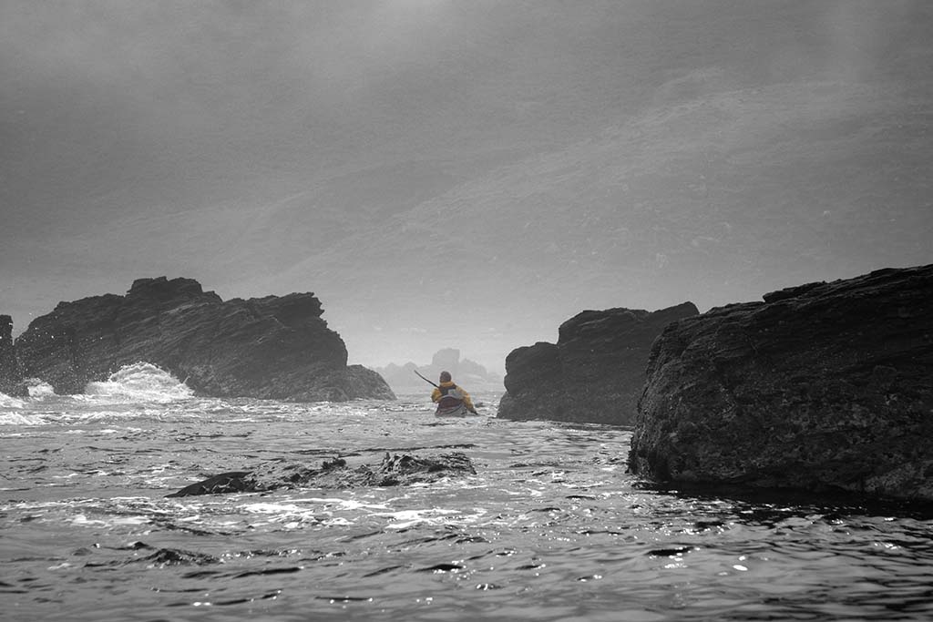
 ...just in time to catch the tide, which would propel us round the Mull of Kintyre. The mist was well down and there was no sign of Ireland. Light drops of rain were falling as squadrons of early morning gannets were heading off round the Mull before us.

We soon passed Port Mean, which is the last landing for 23km if there is any swell. The Magicseaweed surf forecast was predicting 3 to 6 feet of surf at Machrihanish (the surf beach to the north of the Mull of Kintyre) so we were not expecting to be able to land on the only other "beach" on the Mull at Innean Glen. Effectively the Mull of Kintyre is like a 23km open crossing but the tide and the imposing scenery mean you will not experience a moment's boredom.

As we approached Borgadalemore Point, we were travelling at 8km/hr with hardly any paddling effort required. We were now committed to the Mull. There could be no turning back, it felt like we were paddling round the end of the world..

Saturday, June 22, 2013

An Art Deco landmark in the twilight at the Mull of Kintyre.

As we crossed Carskey Bay, on the east coast of the Mull of Kintyre, the wind dropped to nothing. Behind us, beyond Rubha MacShannaich lay the distant outline of Ailsa Craig, Sheep Island and Sanda.

Ahead the coast of Antrim in Northern Ireland merged with the lowering grey clouds. This was the last we would see of Ireland on this trip!

Above the bay, stood the sad remains of the art deco Keil Hotel. It opened in 1939 and during the war it was used as a Royal Navy hospital.  It was also a useful landmark for WW2 Atlantic convoys when all the lighthouses were extinguished. At certain times, the blackout curtains would be opened and the lights lit to guide expected shipping. It was also a welcome landmark for us as it meant we were nearly at our destination. After the war it reopened as a hotel but closed in 1990.

We arrived at our chosen campsite at 9:45pm, some 15 minutes ahead of schedule, despite that pesky headwind. This allowed us to get the tents up before it was completely dark.

Soon we had a roaring campfire going. We could hardly believe our adventure had begun so well and tomorrow, given fair weather, we would round the Mull of Kintyre. Slack water at the Mull would be at 06:40 am the following day, so we would need to have an early start!

Friday, June 21, 2013

A Bastard of a headwind and a Bloody rock..

Unfortunately the fair wind did not last long on our journey towards the Mull of Kintyre and we met a stiff head wind, which combined with an adverse tide, slowed our progress. At this rate we would not arrive at the intended campsite until well after 11pm!

 Due to my shoulder problem I found it hard to keep up with the others.

However, I had insider knowledge that kept my spirits up. By the time we were below the steep slopes of The Bastard Hill we spotted the Isle of Sanda.

I knew that the tide would change before we arrived in Sanda Sound and that it would accelerate us on to our destination.

Indeed, we had 4 knots of tidal assistance by the time we passed Macharioch Bay and the monument to local landowner the 8th Duke of Argyll 1823 to 1900.

Rocky slopes gave way to undulating fields. The first cut of grass for silage was underway some 3 to 4 weeks late, due to the long winter and exceptionally cold spring.

At last we passed the communications mast that marks Rubha MacShannaich beyond which our destination lay. On the horizon we could see Fair Head in Northern Ireland, some 35km away on the other side of the North Channel.

As we entered Carskey Bay at twilight, we paddled in silence below the grim ramparts of Blood Rock upon which Dunaverty Castle once stood. It was a Clan Donald stronghold for centuries but that came to a bloody end in 1647. Covenanter troops besieged the castle as the Clan Donald were Royalists. 300 men, women and children surrendered after the castle's water supply was cut off. They were promised quarter by the Covenanter army but when they walked out of the castle they were almost all killed.

This marvellous reconstruction by Andrew Spratt shows how Dunaverty Castle once looked.