Showing posts with label Colvend. Show all posts

Tuesday, February 23, 2010

Threading the Needle's Eye with the Cetus LV!


The staff of seakayakphoto.com are currently puting the P&H Cetus LV through its paces for Ocean Paddler magazine. So far we have taken her to Mull in the Inner Hebrides, Loch Creran in the Firth of Lorn, the Mull of Logan in the North Channel, Ballantrae on the Firth of Clyde and here at the Colvend coast in the Solway Firth. We have been particularly keen to see how she compares with other kayaks such as the Rockpool Alaw Bach.


From Gillis Crag we continued eastward past Port o' Warren...


...and oyster catchers waiting for low tide at Portling, all on our port side,...


...with Skiddaw, 931m, and the mountains of the English Lake District on our starboard side, until...


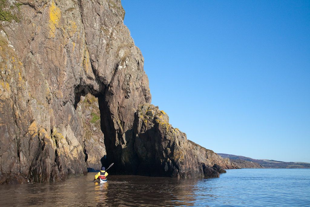
...we arrived at the magnificent arch called the Needle's Eye!


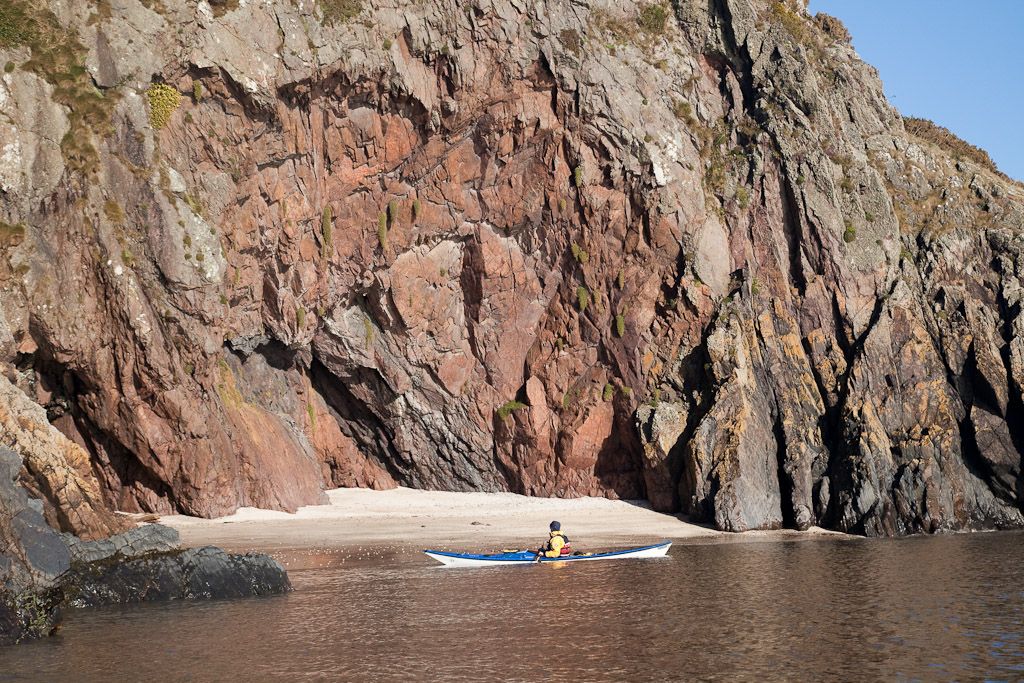
Once through the Eye, we soon came across another of the Solway's treasures. This little cove is not named on modern maps and is completely cut off by steep red cliffs at high tide.


I discovered it is named Piper's Cove on the OS 6" to 1 mile map published in 1854. A cave nearby had green stains of malachite on its walls and was once a copper mine. The name Piper's Cove could equally apply to the cave as in old Gallovidian "cove" could mean cove or cave.


Piper's Cove, what a fantastic name for a special place. What hardships we have to endure, keeping up a busy testing schedule!

Monday, February 22, 2010

More to see on the Colvend coast


At the Bogle Hole the tide turned and started to ebb. If we wanted to travel east with the Canada geese we needed to leave before the full spring ebb was established.


So we slipped out of the recesses of the Bogle Hole and entered the expanse of the Solway beyond.


We soon came to the monument to the wreck of the schooner Elbe, which was wrecked near this point in December 1867. A storm had broken her rudder off in a cross offshore gale but Captain George Wilson, his father Captain Samuel Wilson and 5 crew managed to steer her by trimming her sails so that she nearly came into the rocks. With each wave her bowsprit overhung the top of the rocks and in turn all seven men leaped to dry shod safety. The wind then carried the Elbe out into the Solway where she was lost.


Next we came to the red rock cliffs of the Cow's Snout.


The cliffs tumble straight into the sea but in some gullies you can still see green deposits of malachite which was mined for copper.


By now the ebb was well established and we had to push on to the next...


...line of cliffs at Gillies Crag.

Friday, February 19, 2010

The Bogle Hole, Colvend.


Once through the narrow cleft in the rocks we entered...


...the most delightful hidden cove...


backed by a lovely sandy beach. I have previously mentioned this hidden cove in my Solway podcast with Simon Willis.


Photo T Page.
My knee injury did not allow me to hop around the rocks to take photos from above...


Photo T Page.
...but Tony took my camera and leaped round the rocks like a mountain goat and took these two cracking photos. If you ever paddle the Solway coast, make sure you don't paddle past the Bogle Hole!

Wednesday, February 17, 2010

Mud, tides and windmills on the Solway


Back at the end of January, we drove south to Auchencairn Bay on the Solway Firth. We parked behind the hotel and trollied the kayaks down a delightful lane to the shore. In the distance, beyond the shoulder of Hestan island, our destination, the Colvend coast, lay tantalizingly on the far side of Auchencairn Bay .


Launching here is very much controlled by the tide. The window extends for about 2.5hrs either side of HW Hestan Island. If you arrive and see the mud is still exposed, don't even attempt to cross it, it is glutinous, evil smelling stuff that you will carry round with you for many weeks to come. Being the Solway, the tide will come in very quickly, so be patient and wait just a little until it is covered.


On launching, we first turned west along the cliffs of Balcarry Point. In the spring and early summer, these cliffs come alive with thousands of sea birds such as guillemots, razorbills and fulmars. Today...


...all was quiet as we explored the stacks at the base of the cliffs....


...before turning east to cross Auchencairn Bay. To the south, the windmills of the Riders Rigg wind farm were silhouetted against the distant snow covered mountains of the English Lake District.

Monday, May 07, 2007

The Dundrennan and Colvend coasts of the Solway


The Colvend coast: evening light on the sands revealed by a spring low tide. Hestan Island is in the distance. This steep road leads down to the hamlet of Port o' Warren.


The Dundrennan and Colvend coasts of Galloway on the Solway Firth can offer some challenging paddling conditions. At the weekend we took advantage of a spring flood tide to carry us up the coast from Abbey Burn Foot to Sandyhills. The spring tide set up overfalls at several of the headlands particularly from Lot's wife (a guano covered stack) to Balcary Point and between the monument and Cow's Snout. Shallow seas, clapotis from the sheer cliffs and a force 5 wind all contributed to a bumpy ride and I managed few photos.


Abbey Burn Foot is in the middle of the Dundrennan Range, a weapons firing range. The beach is often closed to visitors but was open this weekend so Tony, Billy and I took advantage.


The launch was a bit rough over boulders.


The weatheronline database recorded a force 5 southerly at the Dundrennan Range weather station.


Sandstone caves below Barlocco Heugh.


Castlehill Point was not as rough as some of the others.


The Needle's Eye arch on the Colvend Coast.


A stunning, remote, sandy cove just before Sandyhills Bay with its bank holiday crowds. We arrived at Sandyhills at high water. If we had been delayed and had to fight against the ebb, it would have been even rougher with breaking seas in the shallow wind against tide conditions.