Tuesday, March 27, 2007

Ferry gliding in strong winds.

All good sea kayaking blogs should carry instructive posts on technique. Today I have decided to tackle the important skill of ferry gliding in strong winds. I hope I am not presuming too much in that at least some readers will benefit from my experience of this issue.


On Sunday David and I went to Loch Fyne. I was a bit tired after a 30 km paddle round the Mull of Galloway the previous day. There was only two of us, so we took the Aleut Sea II double. Normally people don't come with us if we take the double as it can be quite fast.

It was quite breezy with a force 5 to 6 SE wind blowing up the loch. We pottered around in the shelter of the east side of the loch. There was a lot to keep us occupied, a vitrified fort, an old jetty, lovely sandy bays backed by indigenous woodland, little islands off shore and the biggest man made hole in Europe (830,000 cubic metres). We stopped for several luncheons, the last at lovely Ascog Bay but then I got a bit bored.

Looking out into the loch I noticed the wind and the driving waves heading straight downwind towards Tarbert. Goodness me, Tarbet has pubs and an ice cream shop! Then I remembered a chat with the guys from Stornoway canoe club. They are right into paddling downwind in the long sea Lochs of Lewis. A cunning plan was therefore hatched; to partake in some refreshment and gelati at Tarbert.


It was quite breezy and we covered the 8km at an average speed of 10.6km/hr with a maximum speed of 16.9 km/hr. The photograph does not really do justice to what the sea felt like. Despite paddling downwind, our paddles were being snatched by the wind. The waves were short and steep and did not seem to fit the length of the Aleut very well. One moment I would be surfing with free air under my seat in the front cockpit. The next the bow was buried up to my spraydeck with the rudder trying to get a grip in the air. With the boat threatening to broach we had to paddle like.... well vigourous sweep strokes were required!


I was quite tired by the time we got into the shelter of Tarbert.


Suitably refreshed we thought we had better make a start on the return journey. I noticed that the wind had now backed round to the east and was now straight in our teeth for the crossing back to Portavadie.


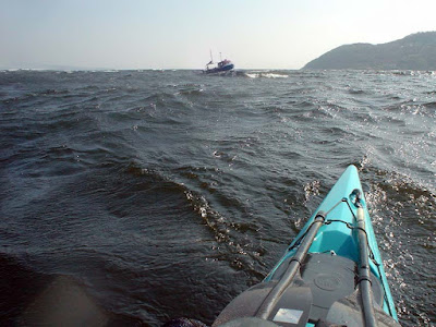
Paddling out of the shelter of East Loch Tarbert I noticed the line of breakers out in Loch Fyne. I also noticed the fishing boats were all returning to port. To make matters worse, paddling at full speed we could only make just over 2km/hr and that was before we hit the waves out in Loch Fyne. I stopped paddling to take the photo above and the wake shows we were going backwards despite the fact that David was still paddling like... well quite hard. A near 3 hour crossing at the end of a tough weekend's paddling did not hold much attraction. Then I saw a ship! A new plan, we turned our bow back towards Tarbert....


We had a very pleasant ferry glide home on MV Loch Riddon.

Monday, March 26, 2007

A perfect day to end up in 2000 Acres of Sky.


On Saturday we paddled to Port Logan, which featured in the BBC series "2000 Acres of Sky". The series was based on a fictional and remote island community called Ronansay which lay off the west coast of Skye.

Port Logan was originally called Port Nessock and in the 17th century attempts were made by the McDouall family to establish it as a ferry port for Ireland. They also built the Port Logan Inn which now makes a fine sea kayaking pub. (See here for what makes a good sea kayaking pub.)

The quay and Port Logan Light were built in 1830 by Colonel Andrew McDouall. The light is a conical stone tower with a platform for a lantern. It is not known when it was last lit but for sometime after that it had a bell, which was rung to guide local boats back in foggy conditions. A decent road to the village was not constructed until the early 20th century, so most of the village's trade and traffic depended upon the sea. A life boat station was built at Port Logan in 1866. It closed in 1932 as the RNLI lifeboat at Portpatrick, 18km to the north west, was motorised by then. The boat house is now the village hall which you can find near the quay.


We set off from Drummore and so had to pass one of the great headlands on mainland Britain. The Mull of Galloway is the most southerly point on Scotland. It juts into the Irish sea separating the Solway Firth from the North Channel between Scotland and Ireland. We were prepared for the strong tides and magnificent caves. What we were not prepared for was the stunning cliff coastline north west to Port Logan.

17/04/2007 lv asked "Do you have a panoramic photo of Port Logan?"

I do but it was shot in pretty flat light so it is not the best. Here it is...


I do not know where you stay but if you get the chance, you should visit Galloway. It is a wonderfully unspoilt region.

Sunday, March 25, 2007

What a difference a day makes.


Yesterday we enjoyed sun and light winds rounding a major headland. Today when the clouds cleared and the sun came out, it brought a fresh SE wind. It funneled into the mouth of Loch Fyne in the Firth of Clyde. We paddled out into the middle of the loch where the wind and waves were at their best.


David in the Aleut Sea II


Then we turned downwind for a 6.5km blast to Tarbert with its ice cream parlour and the pub.

All in all, a pretty good weekend

Saturday, March 24, 2007

Rainbow rock


Earlier today


A clue to rainbow rock's location. This cave is directly below one of the most prominent lighthouses on the Scottish mainland.

Wednesday, March 21, 2007

An Orange future for Barra and Vatersay but not for me.


This photo is of red haired, celtic cows on Bagh a Deas on Vatersay, the most southerly of the inhabited isles in the Outer Hebrides. It is especially for Michael, Hayden and Wenley and is one of a series of sea cow photos I am posting on this site.


On sea kayaking trips to the Outer Hebrides I usually take three PAYG SIM cards for O2, Vodaphone and Orange and I usually get mobile phone reception in most places but until now, not on Barra or Vatersay.

However, Orange recently started work constructing mobile phone masts on Bruernish and Bentangaval. It was hoped the network would be available from 09/03/2007. The mast at Bentangaval will also be used for the deployment of services provided by Connected Communities Broadband to create a wireless Internet network on the island.

The future might be Orange for Barra but not for Newton Mearns on the south of Glasgow. On 17/1/2007, as a result of local loop unbundling (LLU), Orange installed their own ADSL broadband equipment to replace equipment they had rented from BT. Since then my broadband has been just about unusable with download speeds of about 100 kbps (instead of the theoretical maximum of 6,500 kbps) and frequent drops of the connection. After much frustration, yesterday I requested my MAC code to transfer to another ISP. I will not be going to one of the free bundles with other services such as Sky satellite TV. I will be happy to pay for a decent reliable service.

Tuesday, March 20, 2007

Bag, a deer.


Kinloch Castle on Rum was built as a shooting lodge. It is full of stuffed things that once flew, ran, crawled or swam.


Its shooting books record days of hunting. On September the third 1925, Sir George Bullough killed a 7 point stag weighing 14 stone and 4 lbs on Kilmory hill with a 0.303 inch rifle. He was assisted by his stalker MacLeod.

Sunday, March 18, 2007

In search of the monkey eating eagle of Rum.


The island of Rum is a rum old place. Most people associate it with the sea eagle but there are other eagles to be found on the island. On one of his trips on his yacht, SY Rhouma, George Bullough visited Japan and became friends with the Emperor. The Emperor gifted him this bronze monkey eating eagle with two matching incense burners, each topped by lesser eagles. George packed them away in a nook somewhere on Rhouma and brought them back to Kinloch Castle as souvenirs of his Far Eastern travels.


They now fight for attention with his other amazing collection of bric-a-brac and gegaws in the castle's Edwardian front room.

PS several people have emailed asking why I have stopped posting about weekend trips. Unfortunately since I spent some time working in the Children's Hospital in Pakistan I have been bothered by recurrent chest infections. I have not been out for three weekends now and I had to cancel a trip to Skye this weekend. So you will just need to put up with shots from the back catalogue for a little longer. :o)

Saturday, March 17, 2007

SY Rhouma


George Bullough, who built Kinloch Castle on Rum (or Rhum as he called it), also owned the Clyde built, 221 foot, twin deck, sailing yacht Rhouma. The name is supposed to be the feminine of Rhum. He sailed round the world in Rhouma. During a visit to Japan he became friendly with the Emperor.


He liked to fish for tarpon from the Rhouma and several adorn the walls of the corridors in the castle.


He gave the SY Rhouma to the British government to use as a hospital ship in the Boer War. He also paid for it to staffed by doctors and nurses. Her magnificent sixteen piece dining suite was removed to the castle. You can see the swivel points where the chairs were secured to Rhouma's deck but allowed diners to rotate the chairs for easy entry and exit.


The Rhouma's bell now sits silently on a table in the hall of the castle.

I thought sea kayaking was expensive....

Friday, March 16, 2007

Kinloch Castle, Rum


Kinloch Castle with a sea kayaker in front for scale.

Yesterday I posted an item about a red sandstone castle on Arran. Here is another one. It is Kinloch Castle on the Island of Rum in the Inner Hebrides. It is situated in a sheltered position under the Rum Cuillin at the head of Loch Scresort on the east coast of the island.


It is not an ancient Scottish castle but was built as an Edwardian shooting lodge by a wealthy Lancashire industrialist called George Bullough. There is no suitable sandstone for building on Rum so all the stone was imported from Annan in Dumfriesshire and brought here in small west coast puffers. It was completed in 1901 and was the first private building in Scotland to have elictric lighting. The electricity was supplied by a small hydro electric dam in the mountains behind.


You can camp near the Castle, but the gas powered midge eating machines can hardly cope with the particularly voracious breed of midge which is to be found in these parts. I therefore recommend staying in the hostel which is situated in the castle's servant quarters. No four posters for us plebians then!

Thursday, March 15, 2007

Brodick Castle


Seakayaking past Brodick Castle.

On our recent seakayaking trip to Arran in the Firth of Clyde we paddled across Brodick Bay. This gave us a wonderful view of the Caledonian pine forest that hugs its northern shore and the castle grounds. Brodick Castle is built on a lofty position and its red sandstone walls rise in magnificently splendour amidst the red barked pines. It has a similar island and mountain situation to Kinloch Castle on Rum, which is also built from red sandstone. It was reputedly built from the same quarry on Arran as Brodick Castle however, its stones came from Dumfriesshire.


On a long summer’s day, the castle would have been an essential stop. It was built on a site that has been fortified since at least the fifth century. The original stone keep was built about 1266 but it has been extended and modified many times since then as it played an important part in the Wars of Independence first from the Vikings then from the English. It was extensively rebuilt in the nineteenth century as a shooting lodge.

It was in the Hamilton family’s hands for nearly five hundred years but following the marriage of the last male Hamilton’s daughter; it passed to the Montrose family in 1906. Their descendants bequeathed, it in lieu of death duties, to the National Trust for Scotland in 1958 and now any one can enjoy its buildings and gardens. Look out for the summer house which has an interior is covered with pine cones.

Wednesday, March 14, 2007

Dove Cave


Wigtown Bay on the Solway Firth not only has a rock arch it has several decent caves as well. This one is Dove Cave.


It does not look much from the outside, but even a Valley Aleut Sea II was dwarfed inside. I will post a review of this excellent double shortly.


The back of Dove Cave and yes there were resident rock doves.

Ravenshall Arch


Time for another arch. This one is Ravenshall Arch in Wigton Bay, Solway Firth. And yes, there were ravens about!

Monday, March 12, 2007

Signs of spring..


Our Canadian and American friends have been posting pictures of freezing and snowy conditions on their side of the Atlantic. Well, we do get snow over here too. This was exactly one year ago. The boat is a polyethylene Point 65 Crunch, a super-fast boat. I will post a review of it, which I did for Paddles mag, sometime soon.

As for today, there was no snow here in Glasgow, instead the plum blossom came out! Rather sadly I found the male blackbird, which has nested in the same place in our garden for the last 12 years, lying dead. He had started his dawn chorus about 3 weeks ago but I had not heard him for the last three days.

Sunday, March 11, 2007

A grey day on Floday!


Really getting into this grey business now!

The remote island of Floday lies at the mouth of Loch Roag on the north west coast of Lewis in the Outer Hebrides. On a wet, grey day our sea kayaks slid into the lagoon on its southern shore. The subtle colours of these Lewisian gneiss boulders stood out from the greyness. These rocks were formed 3,000 million years ago. They seem to have faded quite slowly.

Saturday, March 10, 2007

Stornoway Grey


Yesterday I sang the praises of the subtle shades of grey that make the landscape of the Outer Hebrides so appealing.

Quote "I loved the contrast of the dazzling white shell sand against the many greys of the rocks, hills, sea and sky. They say the Inuit have a hundred words for snow. Well, the Gaels have a hundred words for grey."

It would appear that one of them is not Stornoway grey, or rather Stornaway (sic) grey, which is a paint shade available on the new and well received LandRover Freelander2


Photo credit LandRover

Councillor Angus Nicolson, writing in his weblog, has been truly insulted and is concerned that the name, Stornoway grey, will give potential visitors the wrong impression of the islands.

Well, although I love the islands' greys, the light changes five minutes later and there is a blaze of colour, especially the machair in the summer.


I do not think Angus should be too concerned about Stornaway Grey Freelander2s cluttering the streets of Chelsea. However, can you imagine the glorious sight of 181 wind turbines, all finished in sparkling Stornoway grey?


Photo montage by Lewis Wind Farm


Map of proposed Lewis Wind Farm showing position of turbines. The M25 round London is overlaid at the same scale.

Friday, March 09, 2007

Castaway


From 1/1/2000 to 1/1/2001 the BBC ran a TV series, Castaway 2000, which followed the lives of 36 adults and children who were castawayed on Taransay off the west coast of Harris in the Outer Hebrides. As you might guess from this blog, I do not watch a great deal of television but I did watch this programme for the glimpses of wonderful Hebridean seascapes, skyscapes and landscapes.

Billy and I landed and camped there in July 2005. I loved the contrast of the dazzling white shell sand against the many greys of the rocks, hills, sea and sky. They say the Inuit have a hundred words for snow. Well, the Gaels have a hundred words for grey. We made two attempts to return in 2006.


In June 2006 we were on MV Dundarg but a force 7 prevented us getting near Taransay and we sought shelter behind Scarp further to the north.


We tried again in July 2006. You can just about make out Taransay through the mist.


Unfortunately there was a little shore break to negotiate and I have to report that we (fair weather paddlers) wimped out at this opportunity to display our kayaking prowess. It can be quite a challenge to become a castaway on Taransay.

Thursday, March 08, 2007

In search of a Stone Age Queen.


The north east tip of the lovely isle of Inchmarnock in the Firth of Clyde is a great bank of stones. At the end of the Neolithic Age and the start of the Bronze Age, some 4,000 years ago, the stones on this beach attracted a group of people who built a large cairn just above the shore.


Jennifer and Tony explore the cairn.

Their efforts were sustained by the fertility of Inchmarnock which at that time was covered with oak and hazel forests which were teeming with wildlife. Nearby an ancient deposit of hazel shells, three feet deep, has been uncovered. Beside the cairn these people buried the body of an important female member of their tribe.


She was buried with a magnificent jet necklace inside a grooved and rebated cist. The cairn and the cist were excavated by Dorothy Marshall in 1960. The skeleton became known as the "Queen of the Inch". Her necklace is now on display in the Bute Museum. It was originally thought to have been made from local lignite but it after being studied by the National Museums Scotland (using X ray fluorescence spectrometry) it has been discovered that it is composed of at least five older necklaces made from Whitby jet. This and the style of the cist suggest a link between the West of Scotland and Wessex (and in turn to Brittany).


Looking north west from the cairn to the mouth of Loch Fyne.

After being excavated and carbon dated the skeleton was returned to the cist in its original site and a glass lid was fitted. Which sea kayakers could resist exploring for such a find? Not us! Hamish Haswell-Smith in The Scottish Islands gives the position of the glass covered cist as 80m to the SSW of the cairn. We searched very carefully but could not find it. The stone slabs below were in about the right position.


Was this the site of the cist?

As you can see the ground is heavily trampled by a herd of organic highland cows. We wondered if the stone slabs might be over the cist to protect it or whether it had been removed and the slabs now marked its original position. I decided to write to the owner and his wife replied as follows:

"Dear Douglas

thank you very much indeed for your email. As you can see I am out of the country at the moment. I have a lot to tell you but if it can wait until my return to the UK I will give you a full brief. Everything is in safe hands and all will be explained."


Perhaps it will still be possible to see the Queen of the Inch in her glass covered cist.