Over the last three months I have had increasing problems with my left knee, which has also now started to dislocate. Both knees are very painful so I have not been any long car or sea kayak journeys. Last weekend was so nice that Tony and I set off on a local paddle from Seafield in Ayr towards Maidens, further down the Firth of Clyde.
We had taken sails but they remained unleashed. We passed the Heads of Ayr in a flat calm.
As the sun swung round to the south, we were dazzled by its low rays. Tony found a new use for a laminated map, after all we were locals so we knew where we were going.
Off Dunure, we met Phil, Tom and Julie and we all paddled on towards Croy with Ailsa Craig on the horizon..
We had last met Tom on a trip to Lady Isle further north in the Firth of Clyde. Julie and Tom live in South Ayrshire so these are also their home waters.
We passed a large flock of roosting gulls on the rocks to the north of Croy Bay...
...where it was time to stop for lunch. What a hardship, making do with local waters!
Imagine you are at the edge of the sea on a day when it is difficult to say where the land ends and the sea begins and where the sea ends and the sky begins. Sea kayaking lets you explore these and your own boundaries and broadens your horizons. Sea kayaking is the new mountaineering.
Showing posts with label maps. Show all posts
Showing posts with label maps. Show all posts
Thursday, November 10, 2011
Sunday, March 28, 2010
Google maps, short by an Insh!

Back in early February, we found ourselves all ready for another adventure. After an early start, we were ready to launch at 0915 from Ellenabeich on the island of Seil in the Firth of Lorn.

We had in mind a bold route for a short winter's day. It would take us 44km across to the island of Mull into Loch Spelvie, portage into fresh water Loch Uisg then portage into Loch Buie. The final 24km leg would be done without landing and would involve crossing the Firth of Lorn at night with an ebb tide to contend with.

We chose to launch from the Easdale ferry slipway because of my bad knee. Normally we launch down a rocky beach from the large car park to the north of here. You do need to be quick to keep out of the way of the ferry as it only takes a few minutes to cross back and forwards.

We were bound first of all for the north end of the rocky little island of Insh. Sadly neither Insh nor the neighbouring Garvellachs and Slate Islands seem to be important enough to be shown on the otherwise excellent Google maps!!

Looking to the south west there was a wonderful prospect down the Sound of Insh. The bold outline of Scarba with the Slate Islands in front, then more distant Jura. Nearer at hand the Garvellachs with distant Islay behind then finally the steep eastern slopes of Insh.

As we approached Insh the ebb tide became stronger and we rested for a while in a kelp bed behind a shallow reef...

...before a final sprint, under the distant mountains of Argyll...

...took us to the rugged red rocks of Insh.
Google Maps really don't know what they are missing!
Thursday, January 22, 2009
No saints on St Kilda!

The door of the church on Hirta on St Kilda is on the end away from the sea and the prevailing wind. It is a plain building, with little ornamentation. This is not only because of the relative poverty of materials on St Kilda but because of the zealous form of Protestant Christianity which was practiced here in the 19th century. There are of course no figures of Jesus on the cross, or of Mary or the Saints....

.... talking of which, even the name St Kilda is a misnomer. There was no St Kilda. It was a later corruption of the name "Skildar", which appeared on the Nicolay Rutter (chart) published in 1583. One theory is that Skildar is from the old Norse word for shield. From a distance, the cliffs of the St Kilda archipelago look like shields rising from the sea.
The earliest written reference to the islands was to "Hirta" in 1549. Sir Donald Monro, High Dean of the Isles, wrote a manuscript: "A description of the Western Isles of Scotland called Hybrides" following a tour made in 1549. Here is a quotation from his description: "The inhabitants thereof ar simple poor people, scarce learnit in aney religion, but M’Cloyd of Herray, his stewart, or he quhom he deputs in sic offfice, sailes anes in the zear ther at midsummer, with some chaplaine to baptize bairnes ther, and if they want a chaplaine, they baptize ther bairns themselfes."

This is the view from the pulpit, which is reputed to be the biggest in all of the Western Isles. From it, the minister would preach long, long sermons. He also had a remarkably clear view of the door, so there was no escape!
03/06/2008 am
Tuesday, November 11, 2008
Ailsa Craig, Rev R Lawson,1888

I found this little book recently. It is beautifully written and illustrated with line drawings. It describes the history, topography and natural history of the isle of Ailsa Craig. The Rev Lawson was a minister in Maybole, Ayrshire. He was a keen historian and wrote several books on the history of Ayrshire.

This map folds out from the front piece and to this day it remains the best map of Ailsa Craig available anywhere.
I like old books.
Tuesday, July 08, 2008
Sea Kayaking St Kilda: Na Cleitean Stac

Leaving Bradastac, we passed under further huge cliffs below Glacan Mor. We saw another stack ahead, Na Cleitean stac, and in the distance the headland of Gob na h-Airde with a cloud capped Soay behind.

Na Cleitean stac with kayakers behind. Photo Jennifer Wilcox.

As we approached the headland of Gob na h-Airde we realized we would not be paddling round it, there was a tunnel right through it!

Several people have emailed about my source of the names of the geological features that are not on the OS 1:50,000 map. I have used the Mathieson map from 1928.
Monday, February 25, 2008
Crinan, the gateway from the Clyde to the west coast.

Continuing our recent paddle in the waters of the Dorus Mor, we approached sheltered Loch Crinan. In the summer this bay will be full of moored yachts. Most of them will of course remain on the mooring for the summer with perhaps a weekend trip motoring up nearby Loch Craignish to Ardfern.

The village of Crinan stands on the rim of a steep promontory in the loch. It is sheltered by the wooded isle of Eilean da Mheinn. In the 1580/90s, Timothy Pont mapped this part of Scotland. He annotated the map thus "heir is a herbory for a ship at ylen Damein & also wthin the throat of the river".

The sea lock of the Crinan Canal.
Since his time, the Crinan Canal was built between 1794 and 1816 by John Rennie and Thomas Telford. It is 9 miles long, has 15 locks and rises to a height of 65 feet. It connects Ardrishaig on the Clyde with Crinan on the Sound of Jura. This saves the long and dangerous 128 mile long voyage round the Mull of Kintyre.
There is a fine hotel here with a very good public bar but for once we decided to make best use of the unseasonal sunshine and paddled on! We must return on a rainy day!
12/02/2008
Friday, January 05, 2007
A matter of maps and rutters.
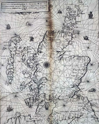
The Nicolay rutter was the first accurate chart and pilot for the Scottish coastline. (The word rutter comes from the French routier.) It was unsurpassed for accuracy for several hundred years. Those of you who know the Solway might question the island off Burrow Head to the east of the Mull of Galloway.
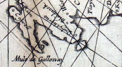
It is of course the Isle of Whithorn. Despite its name this is no longer an isle, but it was when the map was drawn. Even in the 18th century, there was still a channel at high tide and a smugglers' boat escaped the Excise cutter by sailing into the harbour and escaping through the channel while the cutter blocked the harbour entrance.
The rutter was created following an anticlockwise voyage round Scotland by King James V in 1540. The original manuscript was made by Alexander Lyndsay. It was made into a printed version in 1583 by Nicolas de Nicolay, a French map-maker. The National Library of Scotland has placed a digital copy on their website which can be zoomed to allow examination in detail.Only a few copies of the map survive and the BBC news reported that one is due to be auctioned on January 10th. I love looking at old maps and have a fair collection having inherited many old linen backed Ordnance Survey maps of Scotland (some from Victorian times) from by Grandfather. As the rutter is expected to fetch in excess of £20,000, I have decided not to place a bid on this occasion.
In addition to many paper maps and nautical charts I also have digital Ordnance Survey maps at 1:50,000 from Anquet maps. I bought all the 1:50,000 maps in the north half of Britain for £100. These can be viewed on the computer or dowloaded to a PocketPC. Unfortunately they can not be loaded into my Garmin mapping GPS unit but tracks from the GPS can be downloaded onto the computer and waypoints created in Anquet can be uploaded to the GPS. However, it is great for trip planning to be able to scroll seamlessly round the coast. You can print the map at the original size on A4 paper or you can zoom out to cram more coast onto your A4 or zoom in to make the area covered smaller but easier to read for older paddlers who do not wish to wear their reading specs.
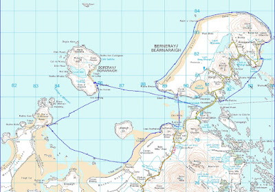
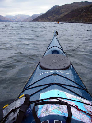
Sometimes I laminate two maps back to back, sometimes I just keep them in the excellent Ortlieb map case.
For the Garmin GPSmap76cs I have two Bluechart regions:2EU006R and 2EUoo4R. These cost about £120 each. They cover from Corsewall Point to Spurn Head. As you zoom in on these you get more detail appearing as the product includes both large scale and small scale charts. They show the coast line in reasonable detail but very little on land. They are useful for showing water depth which can be a predictor for such things as turbulence in tidal channels. They also allow you to calculate tide times for a large number of ports. This works both on the computer and the GPS. Both Bluechart regions fit comfortably within the 115MB memory of the GPS.
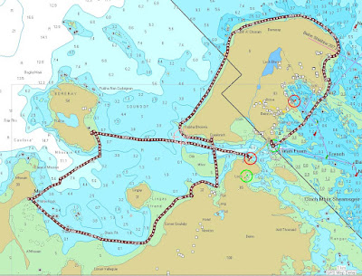
For the Garmin GPSmap76cs to show contours on land and also more detail between HW and LW than the Bluecharts, I bought the Garmin Topo map of Scotland England and Wales for £130. This is based on the ordnance survey but has less detail of woodland, buildings etc but it does show roads. You cannot print from it and on the computer the size of the detailed screen is restricted. On the GPS unit it is very clear and is good for locating skerries, beaches and burns. The maps are large files so you have space to load only those of the general area you are heading for into the GPS, the whole country will not fit.
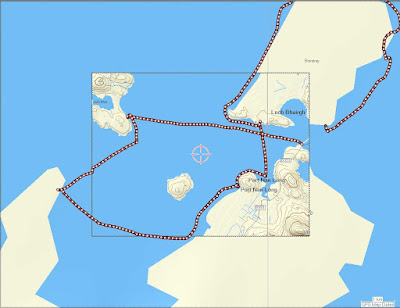
With regard to online maps, I like to use Streetmap in this blog to show the location of photos. It allows me to enter a grid reference from a paper map or Anquet computer map. Pasting the location url into a link in the blog allows readers to open the streetmap page then zoom and scroll.
Another good online "map" is Google Earth. This can even import GPS tracks. Once I have the Google Earth window on the computer screen I save the screen to memory. (On a PC: SHIFT+Prt Scr)
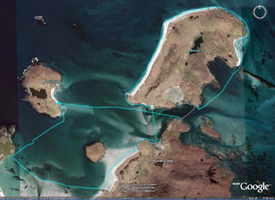
Not all of Scotland has such good photos as this but for those areas with good coverage Google Earth can allow you to explore for campsites and can even show shallows.
It would appear that an advantage of being invaded by the USA is that Google Earth resolution dramatically increases. Ultimately, military use is what has driven the development of maps and also GPS. The British Ordnance Survey had its roots in the Jacobite Rebellion of 1745. In 1746, after the defeat of the Jacobites at Culloden, King George II of Great Britain commissioned William Roy to survey the Scottish Highlands for military purposes. Roy's name is engraved on the door of the Ordnance Survey headquarters in Southampton. Two centuries earlier, James V of Scotland commissioned his rutter to help quell the troublesome Lords of the Isles. The map was so strategic that it was obtained by the English who commissioned Nicolay to make printed copies; one of which was obtained by the French. They used it almost immediately to avenge the murder of Cardinal David Beaton of St Andrews who had been murdered during the Scottish Reformation.
What would Lindsay have made of Google Earth?
On 9/1/2008 Mark added:
"There is another way to get contour information onto a GPS without buying the TOPO maps. The necessary files, Contours v2, can be downloaded for free from the SMC website. You still need the Garmin software to get them on to the GPS itself but they are a big improvement on the Garmin base map.
It seems to work as a sort of overlay on the base map. This leads to some oddities such as sets of contours appearing where the base map shows sea but as the contours tend to be more accurate I have found that helpful as a kayaker!
They were put together by Dave Storey who must have spent a lot of time on it.
Not sure if I can post links here but I will try. The files are at http://www.smc.org.uk/ContourMaps.htm and there is a very helpful set of instructions at http://www.paulmac.force9.co.uk/geo/index.html.
Mark"
Labels:
gear,
GPS,
history,
maps,
navigation,
people,
reviews,
technology,
tides


