Showing posts with label Sanda. Show all posts

Saturday, June 22, 2013

An Art Deco landmark in the twilight at the Mull of Kintyre.

As we crossed Carskey Bay, on the east coast of the Mull of Kintyre, the wind dropped to nothing. Behind us, beyond Rubha MacShannaich lay the distant outline of Ailsa Craig, Sheep Island and Sanda.

Ahead the coast of Antrim in Northern Ireland merged with the lowering grey clouds. This was the last we would see of Ireland on this trip!

Above the bay, stood the sad remains of the art deco Keil Hotel. It opened in 1939 and during the war it was used as a Royal Navy hospital.  It was also a useful landmark for WW2 Atlantic convoys when all the lighthouses were extinguished. At certain times, the blackout curtains would be opened and the lights lit to guide expected shipping. It was also a welcome landmark for us as it meant we were nearly at our destination. After the war it reopened as a hotel but closed in 1990.

We arrived at our chosen campsite at 9:45pm, some 15 minutes ahead of schedule, despite that pesky headwind. This allowed us to get the tents up before it was completely dark.

Soon we had a roaring campfire going. We could hardly believe our adventure had begun so well and tomorrow, given fair weather, we would round the Mull of Kintyre. Slack water at the Mull would be at 06:40 am the following day, so we would need to have an early start!

Friday, June 21, 2013

A Bastard of a headwind and a Bloody rock..

Unfortunately the fair wind did not last long on our journey towards the Mull of Kintyre and we met a stiff head wind, which combined with an adverse tide, slowed our progress. At this rate we would not arrive at the intended campsite until well after 11pm!

 Due to my shoulder problem I found it hard to keep up with the others.

However, I had insider knowledge that kept my spirits up. By the time we were below the steep slopes of The Bastard Hill we spotted the Isle of Sanda.

I knew that the tide would change before we arrived in Sanda Sound and that it would accelerate us on to our destination.

Indeed, we had 4 knots of tidal assistance by the time we passed Macharioch Bay and the monument to local landowner the 8th Duke of Argyll 1823 to 1900.

Rocky slopes gave way to undulating fields. The first cut of grass for silage was underway some 3 to 4 weeks late, due to the long winter and exceptionally cold spring.

At last we passed the communications mast that marks Rubha MacShannaich beyond which our destination lay. On the horizon we could see Fair Head in Northern Ireland, some 35km away on the other side of the North Channel.

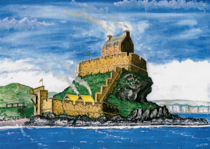
As we entered Carskey Bay at twilight, we paddled in silence below the grim ramparts of Blood Rock upon which Dunaverty Castle once stood. It was a Clan Donald stronghold for centuries but that came to a bloody end in 1647. Covenanter troops besieged the castle as the Clan Donald were Royalists. 300 men, women and children surrendered after the castle's water supply was cut off. They were promised quarter by the Covenanter army but when they walked out of the castle they were almost all killed.

This marvellous reconstruction by Andrew Spratt shows how Dunaverty Castle once looked.

Tuesday, July 31, 2012

Long views from Ailsa Craig.

The path to the top of Ailsa Craig led us past the old castle which was a Catholic stronghold established to welcome the Spanish Armada to Scotland. Unfortunately the Armada never arrived though several of its ships escaped round the north of Scotland and some were wrecked elsewhere on the west coast.

I had warned Mike and Phil that it would take me some time to get up. The path was obscured in places by a thick growth of bracken and nettles but my walking poles were of great assistance though my shoulders ached afterwards.

The MFV Glorious from Girvan arrived with a load of tourists but they were much quieter than the lot she carried on our last visit!

 Mike was surprised how green the summit of Ailsa Craig was.

 We caught our breath at the summit. Unfortunately Phil discovered that his mobile phone did not care much for 12 year old Glenfiddich. His hip flask had leaked in his bag!

There was a stunning view from the top. Pladda and Holy Island could both be seen off the coast of Arran. We counted 21 fishing boats, mostly Belfast registered circling the Craig. MPV Minna was on fishery protection duty and shadowed the fleet.

 The rocky ridges of the Arran mountains rose high over the lower land in the southern half of Arran.

 Sanda, tiny Glunimore and Sheep Island could be clearly seen off the Mull of Kintyre.

To the east the Merrick rose majestically above the hills of south Ayrshire and Galloway.

Whoops, the tide was rapidly approaching the kayaks... It had taken me longer than expected to get up, time to go!

Thursday, May 05, 2011

A distinct lack of nudists at Cleits Shore.

The SW shore of Arran is  superficially less dramatic than its neighbours. A boulder beach is backed by a raised beach which in turn is backed by a line of now dry wave cut cliffs. However, a series of basalt dykes run out to sea for distances of up to a kilometre from the shore.

They are particularly prominent in the region of the Cleits Shore, where they extend for a considerable distance, just under the surface of the water.  You need to give them a wide berth, especially when kayak sailing at speed, with laden kayaks!

I mentioned to David that this shore was a nudist beach, the only legal one in Scotland. Despite David being anxious to get to Kildonan in time for the 3:30 in the Scottish Grand National horse race at Ayr, he now seemed keen to take a break on the shore.

Despite it being legal, there was not a single nudist in sight and neither of us felt like disrobing from the warmth of our dry suits, just to exercise our legal rights.

From the sands at the south end of Arran, we had a fine view of Ailsa Craig, some 22km away to the SSE. We had done this crossing from Ailsa to Arran exactly two years previously.

Twenty eight km to the SW we saw Sanda, with Rathlin Island in the distance to the SSW. There was also a decent wind, which held the promise of a quick sail to Kildonan.

Tuesday, April 05, 2011

Some long views from Ailsa Craig.

On previous visits to Ailsa Craig we have gone in a high pressure system and the visibility has been poor due to haze. On this occasion, the atmosphere was crystal clear. To the ESE Girvan was very clear but in the middle of the photo, the summit of the Merrick was hidden in the clouds. The dip to the right of the photo is Glen Trool.

The view to the S showed Stranraer at the head of Loch Ryan with the Rhins of Galloway and its wind farm on the right.

A telephoto view to the W showed Sanda Island with the Mull of Kintyre behind. In the distance, flat topped Rathlin Island is 68km away off the north coast of Ireland, on the far side of the North Channel.

To the north, this view shows little Pladda Island (with its lighthouse) off the south coast of Arran and the pointed peak of Holy Island to the east of Arran. Right of Holy Island the view is all the way up the Firth of Clyde to the white villas of Dunoon. Beyond that, the snow streaked peaks are Ben Ime, The Cobbler and Ben Narnain in the Arrochar Alps. Ben Ime is 112km away. To the right of Dunoon, the dark island is the Little Cumbrae. To its right you can just make out the chimney of the Inverkip power station. The snowy mountain at the right edge of the photo is Ben Lomond.

Alan (see comments) asked "could I ask if you have a higher resolution photo of the Arrochar Alps, or was this photo already cropped?" This is the highest resolution I have with a 1:1 pixel ratio. It was a remarkably clear day. To the left of Ben Ime, which is the highest point on the horizon, you can see the dark slopes of Beinn Dubh Craig then to its left, the snow flecked ridge of Ben Oss. Lastly, to the left of Ben Oss, you can just see the fine peak of Ben Lui rising above a nearer flat topped ridge. Ben Lui is 1130m high and is 130km from Ailsa Craig, a long view indeed!

Although they don't show up well  on these low resolution photographs, we were surprised by the number of wind farms that had sprouted on the hills all round us. This regularly updated kmz file from weatherman22 will open in Google Earth and show the number of opened and proposed wind farms in the Scottish hills and mountains.

It was now time to make our way back down the steep path to the kayaks.

Monday, January 04, 2010

An early morning wardrobe malfunction.

Alan, Phil and I convened at the Ardrossan ferry terminal for the Arran ferry. We arrived just after 6am for the 7am ferry. We loaded 3 kayaks onto my car and were just about to get in when Alan remembered he had forgotten his dry suit. As it was minus 10.5C when I left my house, we thought a dry suit might be a useful part of his apparel for the day. He calmly decided to drive back to Ayr to get it.


Unfortunately he missed the ferry by just 3 minutes, so Phil and I off loaded his gear and kayak at Brodick and left it for him to collect when he got off the next ferry some 2 hours and 40 minutes later. He was going to paddle round Holy Island.


In the meantime Phil and I drove over to Arran's west coast via the String road which ascends to 234m. At the top the snow was banked on either side of the road. We got a great view of Goatfell, 874m, in the pre dawn light.


Arriving on the west coast we could see Sanda and Kintyre away to the SW.


We arrived at the outflow of the Iorsa Water, under the snow covered slopes of Beinn Bharrain 717m.


The sun rose just as we got ourselves ready, we could hardly feel our fingers by this time.

Saturday, August 23, 2008

The "Ship" lighthouse Sanda


As the mist swirled round we navigated round the SW corner of Sanda and found ourselves under the Ship lighthouse. It is so called because from a distance it looks like a funnel and the rock upon which it stands looks like a ship.


It is situated on the most amazing rock with a natural arch which from some angles looks like an elephant with trunk!


The light was established in 1850 by Alan Stevenson. It has a long white flash every 10 seconds.


Only when you enter the little bay behind the lighthouse do you appreciate what a unique structure it is. Two linked towers with a total of 210 steps like the lighthouse tower to the base of the cliff upon which it stands. The mist added to the surreal atmosphere.

26/07/2008

Friday, August 22, 2008

Sonar and a snoring Sammy seal slumbering soundly on Sanda


After our rounding of the Mull we left the coastline of Kintyre the wind dropped to nothing..


and the the mist began to gather and it was difficult to saw where the see ended and the sky began.


Soon the Kintyre coastline was shrouded in mist and not long afterwards we were enclosed by thick fog again. In the background you can see Dunaverty rock upon which once stood Dunaverty Castle. It is has one of the most bloody histories of all Scottish castles, ending in the massacre of between 300 to 500 Royalists who in 1647 surrendered after a siege to the Parliamentarian Lieutenant General David Leslie.

Our crossing of the strong tides in the Sound of Sanda was guided by GPS and sonar.

The fog was so thick that we were only 30m from Sanda when we finally found it. Our final approach had been guided by a strange deep ZZZZ ZZZZZZ ZZZZ sound that penetrated the miasma.


Just on the rocks we found Sammy the seal cub fast asleep, snoring his head off and completely oblivious to our presence.


Altogether now.... Ahhhhhhh!

26/07/2008