Sunday, December 03, 2006

Indoor echoes of dripping water.


How prophetic was yesterday's post? I went to bed and dreamed of dripping Hebridean caves and woke to a steady drip somewhat closer to home. Last night Glasgow was lashed by winds up to force 9 and torrential rain. My roof was damaged and the rain has driven in.


Today's BBC's synoptic chart shows more winds of up to force 9 again will hit Glasgow and the Clyde. I would normally have gone windsurfing at Troon but I have a dental abscess at the moment. A sore head and a leaking roof are not a good combination. I must cheer myself with another summer memory.


PS Sunday 21:25 hrs. Wind and rain are increasing; strategic pots have been placed. Why oh why did I post about dripping water?!!

Saturday, December 02, 2006

Subterranean echoes of dripping water.


As I paddled alone deep inside the cave, the sounds of the outside world gradually diminished. There was only the gentlest of swell and it hardly disturbed the calm at the back of the cave. After some moments my ears and eyes gradually adjusted to the noises and colours in the cave. There was the most wonderful sound of water dripping from the darkness of the cave roof into the sea beside me. The drips echoed round walls of iridescent reds and greens above a turquoise sea.


This is sea kayaking

Friday, December 01, 2006

Easdale buoys, fools and slates.


We took the Aleut Sea II out to the small island of Easdale that lies off the west coast of Argyll's Island of Seil. We landed on a beach of dark grey slates.


These buoys adorned a building of slate.


Climbing to the top of the island, we saw the great flooded slate quarries that have hollowed out this island's heart. The photo shows the breaches in the quarry wall that a tidal wave made during the great storm of 1881. At low tide the walls are still complete and locals try and catch the fish that have been trapped inside. The quarries go down to 80m below sea level. At their peak of production, in the 1860s, Easdale slates were exported to, Australia, New Zealand, the Caribbean, the United States, Nova Scotia, Newfoundland and Labrador.


Easdale slate is very fine grained but it contains little cubes of iron pyrites or "fool's gold". If you break the slate open the crystals shine brightly but they soon rust when exposed to the air. If you live in one of the above countries and you come across a building with a slate roof have a look and see if the slates came from the little island of Easdale.

After the collapse of their industry, the miners and their families followed their slates to Australia, New Zealand........ They carried the names of their families and villages with them.

Thursday, November 30, 2006

Cuan Sound.


One of the most fun things to do in a sea kayak is to play in a nice tidal race. Between the islands of Seil and Luing lies the narrow Cuan Sound.


The flood tide is compressed as it travels up the great Sound of Jura and through Shuna Sound until it squirts out through the Cuan sound at up to 15km/hour.


As the tide turns the flow reverses and unlike the tide in more open waters it reaches maximum speed very shortly after turning.


In a recent post about wind farms Iona commented that tidal power is efficient and less intrusive. The Cuan Sound is one of the sites under consideration for a tidal barrage or fence to generate electricity.

We enjoy the Cuan Sound while it is still a free ride through!

Wednesday, November 29, 2006

Psalm 59 on Scarp


In a recent post I mentioned the remote island of Scarp off the west coast of Harris in the Outer Hebrides. After the failure of rocket mail its inhabitants were finally connected to the mainland by submarine telephone in 1947. It was destroyed by a storm in 1970 and the GPO refused to replace it. The islanders finally evacuated Scarp in 1971. By tradition they had left a Bible in each house. By the summer of 2006 the houses were in a sorry state after 35 years of winter storms. In one house pages of a bible had blown about the windowless room.


Some days later we met the gentlemen in the centre of the photograph on Canna in the Inner Hebrides. It turned out he had grown up on Scarp until his family emigrated to Glasgow. We had a book about Scarp Hebridean Island, Memories of Scarp. He was able to identify many of the individuals in old photographs reproduced in the book.

Tuesday, November 28, 2006

Courses, bearings and GPSs


Most sea kayak navigation is done by identifying coastal features, checking on the map where you are in relation to them then paddling towards the one you want to get to. However, fog, night or tide might make things more difficult. I used to be a Luddite when it came to GPS units and it is fair to say that although I am a technophile, I was a late GPS adopter.


In this case I want to paddle to the channel to the south of Pabbay Beag from Stacanan Neideaclibh. The horizon is pretty featureless so I can take a grid bearing off the map, convert it to a magnetic bearing and the course is 89 degrees between the two points. I now paddle on a heading of 89 degrees and I should get there. But if there is a tide carrying me north from the course line, my bearing to my destination will change to say 92 degrees. I will have no way of knowing this unless I have calculated the speed and direction of the current before hand or if I have identified a more distant landmark behind my destination and the two move relative to one another (this is called using a transit). In this case there is no suitable transit landmarks.

This is where a GPS comes in. I set a waypoint in its memory for the place I want to get to by either; 1. entering a grid reference, 2. on a mapping GPS scrolling the pointer to the map position then pressing the MARK key or 3. if I was there earlier in the day, by pressing the MARK key when I was in the middle of the channel.

Next I press the FIND key and select the waypoint. The GPS then calculates the distance and course from your start location. Most GPS units have a GOTO page which displays a large arrow which points on a compass rose to the bearing from your current location to your destination. If you drift off course then the bearing changes. On simple GPS units the bearing pointer points to the top of the screen if you are on course. On more sophisticated units the bearing pointer will point to the destination if it is held flat. This is all pretty complicated to describe and in practice in rough water and if your eyesight is not very good, you will end up a long way off course before you detect the change in the bearing arrow.
In practice it is easier to monitor any change in the bearing as a number. On my Garmin GPSMap76cs I can set the bearing to the destination on a large type screen as a number. This is very easy to see especially for those elder paddlers whose close up vision is no longer what it was. If the tide carries me off course to the north, the bearing might Increase to 92 degrees. I now paddle more to the rIght and the bearing comes back to the course of 89 degrees. If I was carried off course to the south, the bearing might dEcrease to 86 degrees. I now paddle more to the lEft and the bearing comes back to the course of 89 degrees. In practice it is easy to keep within about one degree of the course on typical sea kayaking distances.

The GPS allows you to maintain a perfect ferry angle despite changing tidal flows. This is a function that map, compass, tide tables, chart and your brain would be unable to match. Off course it needs to be used sensibly. If you are crossing a channel and expect to be half way across at the turn of the tide, you may as well paddle straight across on a constant bearing and allow yourself to be carried down tide then up tide and these will cancel each other out and you will not waste time ferrying into the tide. Another point is that GPS units can be set to use various Norths such as grid and magnetic. I always set mine to magnetic so that if the GPS fails I can just switch straight back to the compass.

I explained all this to a friend who is very keen on skin on frame kayaks and Greenland paddles. He was rather dismissive of all this technology and wondered what was wrong with a good old compass. However, I am pretty sure the Inuit did not have compasses (not to mention aluminium frames and polymer skins).

PS in response to Cailean's reply.

In May I was fortunate enough to be part of a group that was led out to the Ecrehouse reef which lies 10 km off Jersey in the path of tidal currents that run up to 5 knots.


The leader was a very experienced local paddler who had been out to the reef countless times. He used local knowledge, his experience, compass, map, tide tables and tidal flow charts to take us out by the southerly route above. It was a safe crossing and allowed us to get carried down onto the Ecrehouse. If we had missed it we would have ended up going to England. However, we battled for 2 km more than we had to into a 3.5-5 knot current which was extremely tiring and a couple of paddlers in the group were very nearly exhausted by the crossing. The leader knew I had a GPS and asked how we were doing at the point we changed direction.

If we had done this crossing using the GPS then I would have set a waypoint about 1 km up tide of the Ecrehouse (at our final change of direction on the chart above) and we would have paddled straight to it.

I do think that being able to ferry at just the right angle using a GPS can conserve a groups' energy to leave a reserve for any unexpected tide or wind conditions they might meet later.
Here is a GPS track of a trip to Ghigha. On the way out it was flat calm and slack water. On the way back there was a 2 knot north flowing tide and a force 6 southerly wind. I used the GPS track not to navigate such a short crossing but to adjust the ferry angle. As you can see it was an efficient crossing in somewhat lively conditions!

Monday, November 27, 2006

Photography, is Photoshop a cheat?


This is a nice photo of a summer sunset off Loch Roag in Lewis. It is very much as I remember it but it is actually composed of 2 separate photos which were taken one after the other but with very different exposure settings. One was taken for the light in the foreground and the other was taken for the sunset. I joined them together later using Photoshop. If I had just set the camera to auto, the kayaker would have been a dark silhouette.

Simon Willis has recorded a Podcast with me talking about sea kayaking photography which should be published in the first week of December. The above photo is one that will appear on his website to accompany and illustrate the Podcast.

Some photographers do not like this type of photo, saying they look unnatural. What they really mean is they don't look like the photos they take! The human eye copes with a much greater range of light as it roves round a scene (with the iris altering its aperture as it goes) than a camera which takes a fixed exposure for the whole scene. Film and digital senors are also much less sensitive than the retina. Whatever, I like the technique and it's really just a development of dodging and burning when exposing a print in the darkroom. I did a lot of B+W photography before moving into transparencies but many photographers missed out the darkroom and have spent most of their careers using transparency film which allows for no post exposure manipulation. It was a highly skilled job getting the correct exposure on good old Kodachrome II transparency film with its 25 ASA speed and narrow exposure latitude. Those photographers take a great pride in getting exposure right first time and Photoshop must seem like the spawn of the Devil to them.

I think you can take photography far too seriously. As I said in the podcast to Simon, I am not a forensic photographer recording a crime scene. I am just trying to capture memories and memory is a fleeting and fickle thing.

Sunday, November 26, 2006

Saturday, November 25, 2006

Wanted: Mink Men!


Mink on Bhacsaigh, Loch Roag.

For the attention of non vegan, unemployed sea kayakers! Scottish Natural Heritage seek persons with the following skills:
  • Boat handling skills.
  • Experience with firearms.
  • Ability to walk over moorland between 8-20 kilometres per day.
  • Good knowledge of the Western Isles.
  • Experience of using working dogs.
Successful applicants will take part in the eradication of the mink from the Western Isles. Natives of North America, these relatives of the weasel escaped from fur farms in the 1960's and 70's. They have spread throughout the islands as they are strong swimmers and are ruthless predators of ground nesting birds. A programme of eradication was started in 2001.


Mink trap on Berneray.

I can proudly hold up my head and say that I have played a small but vital part in this public service. During 2004 we were camped on Boreray. In exchange for some fresh water, I did a favour for the island's sole resident Jerry. I transported a dead mink to North Uist so that he could claim his bounty. It was a very stinky minky.


Boreray, sea kayaking paradise.

Imagine you are at the edge of the sea on a day when it is difficult to say where the land ends and the sea begins and where the sea ends and the sky begins. Sea kayaking lets you explore these and your own boundaries and broadens your horizons. Sea kayaking is the new mountaineering.

Friday, November 24, 2006

Rocket Mail launched after 5 year countdown.


The film "Rocket Mail" was released today just 5 years after it was completed. It is based on the story of a German rocket scientist who came to the remote island of Scarp in the Outer Hebrides. In the 1930’s the first of a pair of twins was born on Scarp but there were complications and there was no phone to summon help. The second twin could not be delivered until the next day. The mother had to be transported across the Kyle of Scarp to Harris and then Stornoway in Lewis by boat, bus and car, some 72 kilometres distant.

Herr Zucher heard this story and set up a demonstration of rocket mail to allow the islanders to summon help in an emergency. Unfortunately the British would not let him use his own fuel and the rocket exploded scattering the charred remnants of the mail. Worse, the Nazi’s later imprisoned him as a British collaborator.


The BBC recreated the rocket launch for its superb series Coast.


The Sound of Scarp, across which the rocket was fired. Can sea kayaking get any better than this?

Thursday, November 23, 2006

Return of the white tailed sea eagle.


This rather poor photo can only hint at the magnificence of the sight of a pair of white tailed sea eagles wheeling in the sky off the wild west coast of Harris in the Outer Hebrides. Sea eagles were persecuted in Scotland and became extinct in the 19th century. In 1975 birds from Scandinavia were reintroduced to Rum in the Inner Hebrides. They have slowly spread and this year there were 33 breeding pairs and 29 chicks were successfully fledged.

The west coast of Harris, what a place to paddle!


Wednesday, November 22, 2006

The Stones of Callanish


Not far from Uig on the Isle of Lewis lies mysterious Loch Roag. You can paddle your sea kayak to the shore at the edge of the moor of Callanish (Calanais). As you approach, you realise that the irregular skyline is composed of great stones raised on end.


You climb to the summit of the moor and you are dwarfed by the circles and avenues of the Callanish Stones which have stood here for over 4,000 years. No one knows what purpose lay behind the labour of our ancestors.


It is only when you get close to the stones that you realise their true beauty.

In the city I had an idea for a photograph. We would carry our kayaks up to the stones and stand them on end among them. Standing there on the moor, it seemed a crass thing to do and they remained on the beach. I am not sure whether our ancestors would have been amused.

Tuesday, November 21, 2006

What was once common and taken for granted.


Common blue, butterfly.


While on the machair at Uig, Isle of Lewis, I spotted lots of common blue butterflies. These were once a common sight on grasslands throughout the UK but intensive farming has greatly restricted their habitat and numbers. Thankfully the Lewis machair had remained unchanged for centuries prior to this July day. It was very windy and the grass it was perched on was waving about. This meant I could not drop the shutter speed enough to get really good depth of field for a crisp photo.


In the background, I heard the "croak croak" of the corncrake. This bird is another once common species which is just hanging on in the fringes of the country.


Sea kayaking takes us to special places. We have two responsibilities. First of all we should not harm these places and secondly we should do our best to ensure their future survival. It is encouraging to see local inhabitants developing businesses that exploit the tourism benefit of a pristine environment.
There are proposals to build two huge wind farms in Scotland. Both would be bigger than any other land wind farm in Europe. One is near where I live on the SE of Glasgow. The other is not far from Uig in Lewis. I am completely in favour of the one near Glasgow.


The Lewis one is very difficult with many pros and cons. Lewis is already self sufficient in electricity generated from hydro electricity so the power will need to be exported to the mainland. They plan a new grid to the central lowlands where the cities are but Scotland also exports electricity so this new power will need to be transmitted a long way to where it will be finally used. A lot of power will be lost through the cables. Jobs will be created during construction and crofters will be able to rent the land which otherwise generates little income. New roads and heavy construction will need to encroach on one of the last wildernesses in Europe.


In city offices we will be able to leave our computers on overnight.

Monday, November 20, 2006

Men of Lewis


Still on the the subject of the Vikings, they did not just pillage, rape and leave their chromosomes in the Celtic population. They also left their chess men. This is a giant wooden effigy of the King from one of the famous Lewis chess sets.


Uig Bay, photo Jennifer Wilcox

These Lewis chess sets were found in the early 19th century under the machair (sandy grassland) which lies at the back of the great Bay of Uig on the West coast of Lewis. They were concealed in a stone chamber that was buried under the sands. There are 93 pieces from four or five sets. Eleven pieces are in the Royal Museum of Scotland in Edinburgh and the rest are in the British Museum in London.

I think the most interesting pieces were the berserkers which represented the rooks. These figures are biting the tops of their shields and have wild staring eyes. These were Viking warriors who were naked or dressed in bear or wolf skins and fought in an uncontrolled rage or furious trance. This is the origin of the word berserk, as in "the sea kayakers went berserk when 15 jet skiers arrived at the previously tranquil beach".

So it's not just chromosomes and chess men that the Vikings have left us, it's words too.

Sunday, November 19, 2006

Victim of fashion.


Every so often a really great new bit of kit comes along. Take the Nokia 6250 as an example. It is shock resistant, dust (and sand) resistant, water resistant, big keys for cold fingers, large Lion battery with 14 day standby, automatic volume control that increases or decreases the loudspeaker volume level to cope with background noise (designed for use on building sites but very effective in a howling wind), outstanding transmission and reception, built in sound meter to set the surround sound on the home cinema and it even lets you make phone calls!

It sounds like the ideal sea kayaker's mobile phone. Yes indeed and where may these paragons of maritime functionality be purchased? Well sadly they were last available in the year 2000 and mine is now 6 years old. A victim of the fickle fads of aficionados seeking the latest fashion flavour in phones, it sold like a brick and was discontinued. It is a brick and I look after it. It has an incredible additional effect on anyone under the age of 50. If I produce it in public, which is rare as I find the necessity to call in such places occurs infrequently, it causes much hilarity and occasionaly, some little sympathy among onlookers.

The shops are full of the latest miniature devices that have a multiplicity of myriad functionalities within their delicate and, dare I say, gaudy and ephemeral cases. None tempt me.

The lack of commercial success of my Nokia 6250 is a metaphor for all that is wrong with our society which is consuming resources and energy and polluting the planet in a spiral of self destruction. Perhaps we should learn to be happy with what we have got and expect products to have a decent working lifetime. My Nokia 6250 has only one failing. It not only looks like a brick, it sinks like a brick.

Saturday, November 18, 2006

Kayaker in the water.


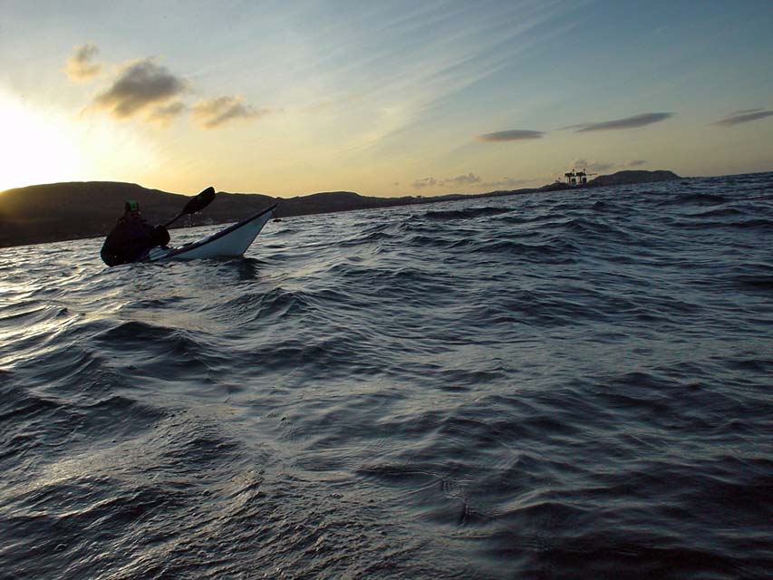
A lot of sea kayakers think they will never fall in because it has not yet happened to them. I suppose there is a sort of logic there, but the sea is an unpredictable mistress and if you go to her often enough...

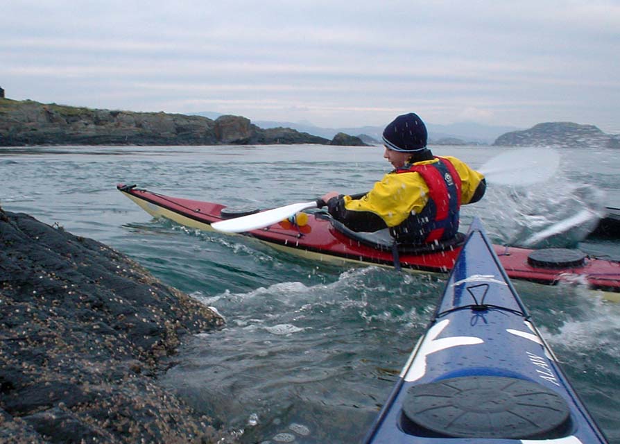
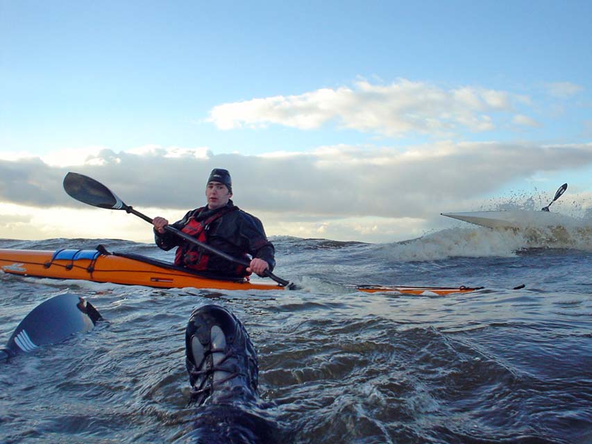
Here is a shot of me enjoying a fine winter swim with Richard and Cailean coming to my rescue. Being dressed in a drysuit with thick fleece underneath, I was comfortable enough to carry on taking photos.


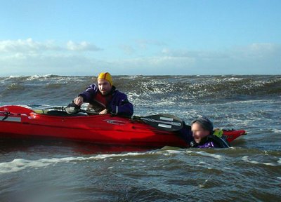
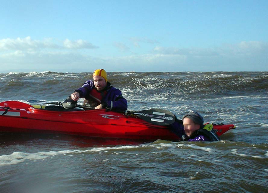
Cailean calmly directs the rescue of another swimmer.

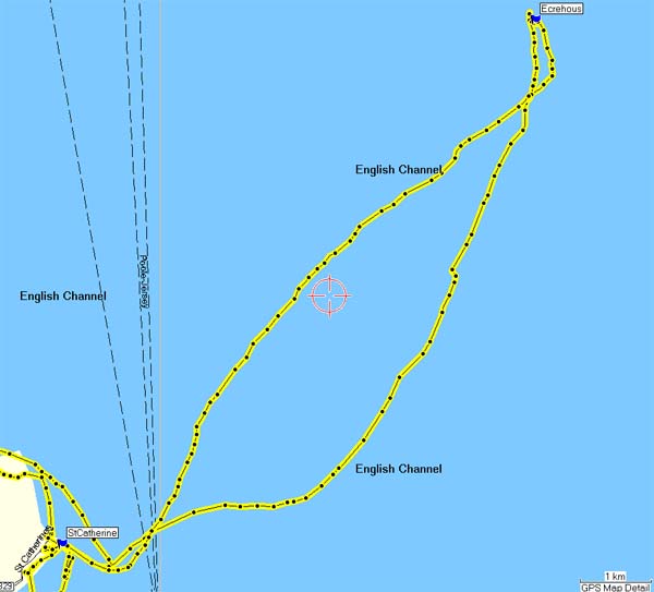
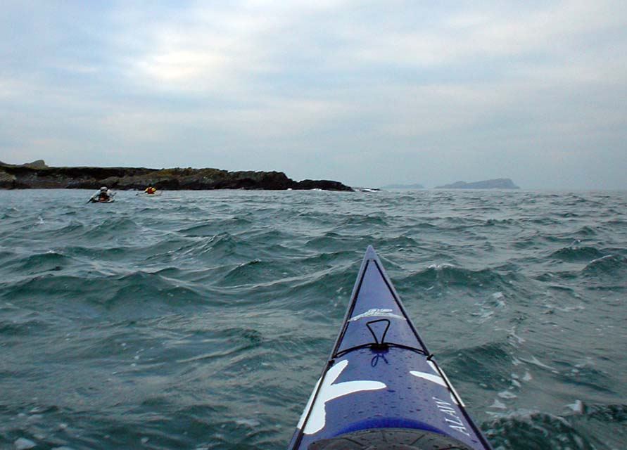
However, recent reports of a sea kayak rescue on the BBC and Coastguard web sites highlighted another danger apart from cold: the possibility of separation from fellow paddlers and the boat. This particular incident had a happy ending because the paddlers were well dressed and had the means to raise the alarm. The helicopter and lifeboats rescued 4 swimmers who had become separated from the rest of their party in a tidal race.

It was wonderful that this potentially serious event had a happy ending, thanks to the preparation of the kayakers and the skill of the rescuers. It makes you think though. If you got separated from your friends and your boat, would you be able to summon help and survive until it arrived?


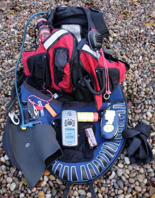
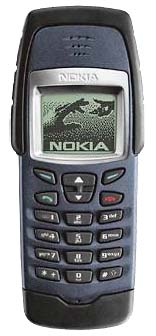
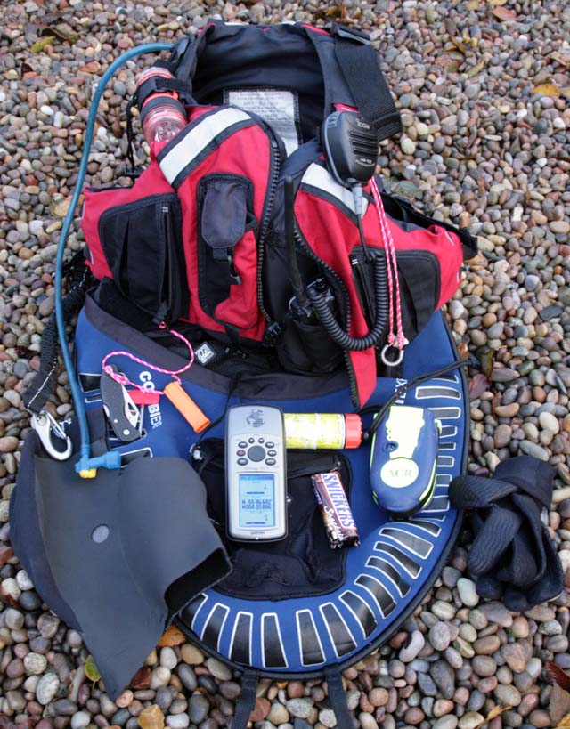
If I was in this nightmare scenario, this is the gear I would find in my BA and spray deck pockets. From the top: combined torch and strobe, drinking bladder, external speaker mike for the waterproof VHF in the BA pocket, in the other pocket is my waterproof mobile phone, noseclip, ACR GPS EPIRB satellite distress beacon, neoprene gloves, chocolate bar, day/night flare, GPS unit with Lat/Long set to BIG text, whistle, knife, neoprene hood, cow's tail with snap link. I have been criticised for the cow's tail but the way I see it, it would keep me attached to the boat if I was too cold and tired to hold on. If I was in the water with another paddler, it would keep us together. I would not use it in surf near the shore.

I think I would prefer to have a polythene Nordkapp RM and an EPIRB rather than a carbon?kevlar Nordkapp.

Be safe out there.

Friday, November 17, 2006

Winter sea kayaking


It has been a fine and mild autumn but outside the gale is blowing and the last of the autumn leaves have been stripped from the trees. The deciduous woodlands have entered the skeletal grip of winter.


In the warmth of the evening living room, the radio road reports are warning of snow on the main road north to the Highlands from Glasgow. Snow is falling between Crianlarich and Glen Coe. The Scottish winter has arrived.


Of course Scottish sea kayakers are a hardy breed descended, as we are, from great Viking and Celtic seafarers.


Hot Scottish blood courses through our veins and a little drop in the temperature scarcely bothers such hardy creatures, whether bearded or unbearded.


However, recent talk (on this very blog) of swimming from the kayak raises some serious concern. Even the resilient Scottish constitution, however fortified or naturally insulated, is not immune from the hyopothermic effects of the winter North Atlantic.


It was not entirely coincidence, therefore, that a package arrived this morning from that reputable manufacturer of dive clothing: Fourth Element. The contents of the parcel were their renowned Xerotherm Arctic top and bottom, designed to provide thermal protection and moisture wicking under a membrane dry suit.

"Using a combination of fast wicking, high insulation fabrics, the Xerotherm Arctic creates a micro climate around the wearer, keeping the body dry and warm. A high density inner fleece provides superior insulation, with maximum comfort and wicking, whilst the outer layer, which has a water repellent finish, ensures a snug fit."

I hasten to add that the fine gentleman pictured above is not my good self. The package from Fourth element was totally devoid of the optional body kit; my dolphin avatar is chosen for good reason. However, it is much easier for someone of my particular athletic build to buy diving attire than cycling wear (how I detest yellow lycra). Although not mentioned on their website, Fourth Element thoughtfully do their large waisted bottoms in a short legged version. Imaginations may run riot in the absence of photography.

I wonder if they do shorts for under the kilt?

If I do run into Deep Trouble, I am confident my thermal protection will give me time to self rescue. Failing that, I hope to survive long enough to hear the beat of the big yellow budgie overhead. I love the smell of kerosene in the morning!

Thursday, November 16, 2006

Longships at Largs: past and present.


The "Pencil" commemorates the site of the Battle of Largs in 1263. The Vikings in Orkney heard that the Scots had become interested in the "Lordship of the Isles", which consisted of the Hebrides and Kintyre. The Lordship was only nominally under Viking control but the thought of a Scots invasion sent their longships south.

After King Haakon IV of Norway made his way through Kyle Akin, the straight between Skye and the mainland, he led his fleet to the Firth of Clyde where King Alexander III of Scotland waited for him. An autumn gale got up and grounded some of the longships. While the Scots attacked the stricken vessels, the main Viking fleet was unable to land its troops in the storm. After five stormy, days King Haakon withdrew the rest of his fleet back to his base in Orkney. He planned to return in the spring but died during the winter. The balance of power had shifted and the Scots regained dominion over the Hebrides.

The Clan Donald were the successors of the Celtic hero Somerled (c1100 - 1164) who was the first "Lord of the Isles". They ruled the Hebrides at first under the Vikings and then under the Scots until 1493. Ironically, for a Celtic clan, their male descendents have been shown to carry a Viking Y chromosome.


Today Largs is one of the most popular venues for Scottish sea kayakers. The Cumbrae Islands are not far from shore and the Isles of Bute and Arran lie beyond. However, the apparently sheltered waters are subject to unpredictable winds, which channel through the islands and surrounding hills. Viking longships are not the only vessels to have come to grief here. Despite its attraction to beginners, many sea kayakers have found themselves taking an unexpected swim. On three separate occasions that I have been paddling here, there has been a swimmer.


Weather conditions are not the only thing sea kayakers need to be aware of. This is a busy deep water shipping channel. Note the kayaker under the bow of the ore carrier Aquabeauty.


Hunterston ore terminal is the deepest water dock in Europe. The jetty runs for one mile out into the channel and it can handle ships up to 350,000 tons. Aquabeauty is a relatively small 170,000 tons. The cranes can off load 2,400 tons of coal or iron ore per hour.