Showing posts sorted by date for query "05/05/2008". Sort by relevance Show all posts

Tuesday, March 10, 2009

Dun Carloway


High on a hill above Loch Rog in Lewis an amazing structure seems to grow out of the ancient rocks. It is the Iron Age broch of Dun Charlabhaigh (Dun Carloway). It was built over 2,000 years ago.


Most of its stones have been plundered over the millenia for neighbouring buildings.


But there is still enough left to explore its double walled structure which contains a spiral staircase.


The plaque from Historic Scotland explains more.

06/05/2008

Monday, March 09, 2009

Return to Miabhaig; all good things must pass.


From Vacsay we turned our bows to the west and made our way somewhat reluctantly and slowly to the Cuma, as she lay at anchor off Bhaltos pier.


After a final supper, we all gathered on deck as Cuma motored slowly and steadily into the recesses of Loch Rog. The Hebridean dusk was gathering as Cuma nudged into her berth on Miabhaig pier. She had motored some 380km since our departure just a few days before. We had only paddled 100km over the previous 7 days but what magnificent sea kayaking it had been. This was not done in straight line headland to headland style. Rather it was a detailed and intimate exploration of some of the most incredible beaches, cliffs, arches, caves, tunnels and geos.

If you ever wish to paddle round St Kilda, I cannot recommend Murty Campbell and Murdani and Cathie Macdonald highly enough.

05/06/2008

Sunday, March 08, 2009

Sea kayaking among islands, lagoons, arches and white sands of Loch Rog.


We now worked our way down the east coast of Pabaigh Mor. This magnificent arch is actually a collapsed cave. (Photo JLW).


The further south we paddled, the calmer the waters of Loch Rog became.


From the south of Pabaigh Mor we then went SE towards Eilean Bhacasaigh (Vacsay). The great arc of white sand, which forms Traigh na Beiregh, rimmed the southern horizon. Beyond, the green and grey hills of Lewis rolled away into the distance.


Inside the lagoon of Vacsay we drifted on still, clear waters with fish gently cruising beneath our keels.


Rounding the north end of Vacsay we entered a hidden tunnel at the back of an inlet.


We emerged into another lagoon but time was now running out on our trip on the Cuma.


The islands of Loch Rog provide a wonderful sea kayaking playground with either shelter or exposure, depending on your wishes.

05/06/2008

Saturday, March 07, 2009

Playing the reef of Bogha Dubh.


At the NE corner of Pabaigh Mor the reef of Bogha Dubh was being exposed by the ebb tide.


The incoming swell from the Atlantic was feeling the bottom for the first time and steepening in the outgoing tide from Loch Rog.


What a great place to play in the sun!


05/06/2008

Tuesday, March 03, 2009

Tony's cave, Pabaigh Mor!


After lunch with LOMO MAN, we continued our exploration of Pabaigh Mor. Round a corner, Tony shouted "Come and see what I have found, it's a tiny little cave!" Clark hung back.


Then BOOOMPH!.... Tony bought a LOMO dry suit shortly afterwards!

Above photos by JLW.


After much entertainment we left Tony's cave and made our way out to the exposed north coast of Pabaigh Mor and its reef of Bogha Dubh....

05/06/2008

Monday, March 02, 2009

The Rise and Rise of Lomo Man!


Something strange began to happen to our mild mannered friend Andy. He began to run around madly looking for a telephone box. Unfortunately there was none to be found on the machair of Pabaigh Mor


Giving up his quest, Andy began to grunt and his facial features contorted.


His whole body began to inflate in size and adopt a turgidity we had not seen before.


Then as his body grew ever more erect, first one arm...


...then the other sprang out into the unmistakable pose of LOMO MAN! Although he wore neither cape nor pants over his trousers, our friend Andy had now transformed into one of the most feared of all the SUPER HEROES!


LOMO MAN caught sight of the ocean and with a final snort, he was off...


.. and like a newly hatched turtle, his priapic figure made a beeline for the water.


At last he was at one with the Ocean and then (hushed David Attenborough voice) he began cooing! A disturbance in the water occurred, at first we couldn't see what was happening...


...and then LOMO MAN emerged with a mate!

When you next visit Pabaigh Mor, keep a sharp eye open for little Lomolettes!

Needless to say, Andy's Lomo dry suit proved to be completely water and air tight during the gruelling transformation from mild mannered kayaker to LOMO MAN!

05/06/2008

Sunday, March 01, 2009

A break in heavy weather!


As we approached the mouth of the Caolas Pabaigh we came across a number of rocky skerries.


The Atlantic swell poured over these in a most entertaining way.


We then proceeded round the west end of Pabaigh Mor, where the chart is reassuringly annotated "breaks in heavy weather". Pessimists think this sounds like an update of "here be dragons"!


Fortunately, we at seakayakphoto.com are eternal optimists and found the perfect spot...


...for a break in heavy weather!

05/06/2008

Thursday, February 26, 2009

Sea kayaking the caves of Caolas Pabaigh (Kyles of Pabbay).


After lunch on the Cuma we launched in the shelter of Caolas Pabaigh a narrow body of water which separates Lewis from the island of Pabaigh Mor.


Both sides of the Caolas are riddled with caves such as this one on the Lewis side.


This monster is on the Pabaigh Mor side has amazing multicoloured rocks.


The booming at the back of the cave was deafening. Just as Tony and I were exiting, a rogue swell came in and I was surfed into the back of the cave again. I found this quite exciting as I tried to do a one handed stern rudder while holding my Canon 5D in the other hand.

05/06/2008

Wednesday, February 25, 2009

The wild west coast of Lewis.


On the morning of the 5th of June 2008, the MV Cuma steamed out of the shelter of Loch Roag for the last time on our trip.


We passed inside of beautiful Eilean Mhealasta...


...and below the dark rocks of Aird Mor Mangurstadh.


We were glad we were not rounding Gallan Head in kayaks, given these conditions.


MV Cuma then nosed into Loch Roag and passed the great arch of Eala Sheadha...


...before Murdani dropped her anchor, a little distance off Bhaltos pier.


Cuma had covered 39km of some of the finest paddling coastline anywhere. I would love to return and paddle it but such an expedition would require much calmer conditions than those we had just encountered.

05/06/2009

Monday, December 29, 2008

Port Appin dawn


Port Appin 
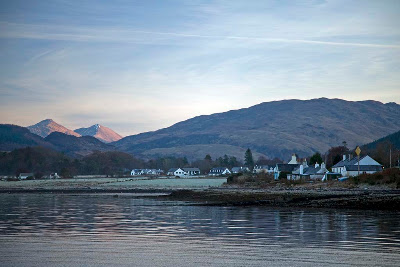
is a sleepy little village which nestles below the mountains of Appin which seperate Loch leven and Loch Creran on Argyll's rugged west coast. Port Appin was never a fishing port but it served as a stopping point in the 19th century for steamers travelling between Glasgow and Edinburgh via the Crinan and Caledonian canals.


Today it serves two small ferries. This is the Lismore which carries foot passengers across the Lynn of Lorn to the beautiful island of Lismore. In Gaelic, Lismore means the big garden. It is more fertile than many of the Scottish islands because of the presence of limestone rock. From 1800 till 1934 this was quarried and heated in lime kilns to produce lime for agriculture on the west coast and building in Glasgow.

The quarrying tradition in these parts started again in 1986 when the Glensanda quarry opened. It is one of Europe's biggest quarries and its granite rock was used to make the channel tunnel. Glensanda quarry is removing an entire mountain, Meall na Easaiche, on the Morven coast on the far side of Loch Linnhe, beyond Lismore. It is situated just behind the mountains in the sunshine in the photo above. Another ferry carries local workers from Port Appin across Loch Linnhe to Glensanda.


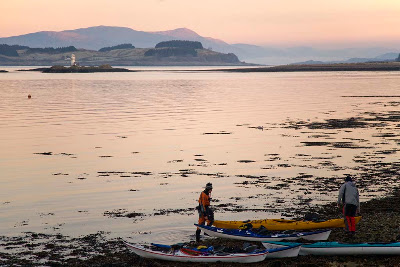
We were bound for a circumnavigation of Lismore and also chose to launch from Port Appin. We carried the boats over frost covered seaweed in the predawn light. Although we were still in freezing shade, there was a lovely pink glow in the sky reflected from the tops of the high mountains which were already in sunshine.


We planned a clockwise circumnavigation. It is 37 km and we knew that it would be dark before we finished as sunset would be about 15:34.

On 27/12/2008 HW Oban was at 05:35 and 17:49. The tidal constant at Port Appin is -00:05 Oban. It was one day before springs.

At the Lynn of Lorn south end (1 knot springs), the ebb (SW) starts at -01:40 Oban which was 16:09 on our trip. The flow (NE) starts at +04:45 Oban which was 10:20.

At the Lynn of Lorn north end (2.5 knots springs), the ebb (SW) starts at -00:15 Oban which was 17:35. The flow NE starts at +06:00 Oban which was 11:35.

On the NE going flood an eddy runs SW from the islands along the SE coast of Lismore so we reckoned we would have tidal assistance for most of the day.

27/12/2008

Tuesday, December 09, 2008

Disembodied heads on the return from Ailsa Craig!


After our exploration of the lonely rock of Ailsa Craig we set off on our return journey in glorious May afternoon sunshine.


It was hot work in the sun as what little wind there was began to die away as Ailsa Craig began to grow smaller on the western horizon.


By the time we were approaching Lendalfoot on the Ayrshire coast, the wind had dropped completely and we paddled accompanied by crazy reflections, some with disembodied heads.


The tide was well out as we landed in the reefs over which we had paddled just a few hours ago. On the horizon Ailsa Craig looked distant again but now we had an exact measure of that distance.

05/05/2008