Showing posts sorted by relevance for query turnberry lighthouse. Sort by date Show all posts

Monday, December 19, 2011

Turnberry to Culzean

After a leisurely lunch at Turnberry beach, we paddled out past the treacherous reefs again.

Beyond the reefs, the wind had dropped and we paddled below Turnberry lighthouse on relatively calm waters. The reefs of Turnberry Point and nearby Brest (or Bristo) Rocks were notorious as the graveyard of many ships making their way to and from the busy ports in the Firth of Clyde. The lighthouse engineers, David and Thomas Stevenson, recommended construction of a lighthouse on the point rather than on the offshore rocks and it was completed in 1873. In a rocky gully beneath the lighthouse, you can still see wooden rubbing strips bolted to the rocks. These were used by boats that delivered the building materials for the lighthouse.

We continued in a NW direction across Maidenhead Bay.

 The snow covered Arran Hills looked absolutely magnificent in the clear Arctic air.

 We made landfall near Port Carrick at the south end of Culzean Country Park and...

...continued as far as  Culzean Castle.

Monday, January 28, 2008

Rockhopping in the wake of the Stevensons.


I have posted about Turnberry lighthouse before. This lighthouse will be a familiar sight to TV golf fans as the Open Championship has been held here in 1977, 1986 and 1994.

Turnberry lighthouse was built on the recommendation of the Receiver of Wrecks in the nearby town of Ayr. The reefs of Turnberry Point and nearby Brest (or Bristo) Rocks were notorious as the graveyard of many ships making their way to and from the busy ports in the Firth of Clyde. The lighthouse engineers, David and Thomas Stevenson, recommended construction on the point rather than on the offshore rocks and it was completed in 1873.


It is funny how we Scottish sea kayakers often find ourselves rockhopping in the wake of the Stevensons.

20/01/2008

Tuesday, February 13, 2007

Turnberry: tourneys, tees, castle and lighthouse.


The steady wink of a lighthouse beacon as the winter sun slips into the west is a reassuring sight. The great light of Turnberry stands on a rocky headland that juts into the Firth of Clyde. It is built upon the sad ruins of Turnberry Castle, which dates from the 12th century.


Only the stump of the castle, seen here in front of the lighthouse, now remains. In its day, it was a magnificent stronghold which was built over an inlet of the sea. A portcullis could be lowered after a ship had entered this sea gate. A reconstruction of the castle in its heyday can be seen on the local town of Maybole's website. The castle was probably the birth place of Scotland's King Robert the Bruce in 1274. He was of Norman decent and it is thought that the name Turnberry has Norman French origins: "Tourney Berg" or castle of the tournaments. Nowadays there is not a great deal of jousting but great golf tournaments are held here during the Open Championship. This will next be held at Turnberry in 2009. The lighthouse is situated just behind the 17th tee and, in previous Open Championships, it has featured in a favoured TV vantage point that beams the view of tee and also distant Ailsa Craig to a worldwide audience of golf fans.

Although spring tidal flows in the lower Firth of Clyde are generally less than 1 knot, the waters off Turnberry Point can be quite lively, even in otherwise calm conditions.

Thursday, June 07, 2012

Seeing the light on Holy Island.

After lunch we set off across the south entrance of Lamlash Bay towards the Inner Light on Holy Island. The island is now owned by Buddhist monks who have built  an increasing number of meditation retreats on the south facing slope above the lighthouse.

The lighthouse buildings are also used for lesser retreats and at the other end of the island they have built a commercial hotel for those that wish to experience Buddhism lite.

Sailing as close to the wind as possible, Mike just managed to squeeze round the south end of the island where...

 ...we passed under the stony gaze of this gorilla with its eyes fixed out to sea. It seemed lost in meditation as it somewhat ignored our passing.

 We now came to Holy Island's Outer Light...

 ...which is also used for meditation.

Only the wild ponies disturb the meditation of devotees who may spend several years at a time in isolation here.

As other Scottish lighthouses such as Turnberry* are gradually being extinguished, it is good to know that some are being put to alternative use.

*The iconic Turnberry lighthouse is due to be switched off by the Northern Lighthouse Board in 2015.


Monday, December 13, 2010

Sun goes down at Turnberry, after a three castle day!

By coincidence, four refreshment breaks had taken so much time that we arrived at Barwhin Point just at sunset.

Both Turnberry lighthouse...

...and Ailsa Craig...

...add a certain something to Firth of Clyde sunsets.
 
The sunset did not last long...

...and soon the flash of Turnberry lighthouse was the brightest object in the sky...

...and we paddled into Maidens in near darkness after a three castle day!

Sunday, February 11, 2007

Sunday afternoon tea and surf at Culzean Castle


Culzean Castle is perched precariously on the edge of cliffs.

It poured all morning but at 12 midday Tony and I decided to head for Maidens on the Ayrshire coast of the Firth of Clyde. The clouds and rain hung over Ayr on the journey down but the sun came out when we launched. The WWW is working well these days, Tony was most impressed.


We headed south from Maidens, past Turnberry light house then headed out into about 1m of swell off Turnberry Point. Then we ran with the swell all the way up to Carrick Bay, to the south of Culzean (pron. Culane). Most of the swell was about 1m but there were occasional biggies and on one of these I got a real good surf up to 20.3km/hr.


GPS screen dump.


Approaching Turnberry Point from the south.


Turnberry lighthouse.


Carrick Bay.

We had a very pleasant cup of tea in the magnificent sandy cove of Carrick which lies under the cliffs of Culzean. After exploring the sheltered shoreline beneath the Castle, we made our way home in the sunset. We got back to Maidens before dark.


Another fantastic day draws to a close.

Friday, December 21, 2012

A medical emergency and moonlight landing at Port Carrick.

When we approached the roosting gulls on Carnage Corner south of Dunure it was pretty obvious that it would be dark by the time we got to Maidens. So we made a decision to cut across the 7km wide mouth of Culzean Bay direct to  Barwin Point. This was to prove to be a major navigational error.

By the time we were only a third of the way across, each of us was struck by a simultaneous medical emergency. Being gentlemen of a certain age, it became very difficult to maintain control over our bladders. There was a pressing need to land so we pushed on across the bay at high speed (so no distracting photos) and landed at Port Carrick, just before Barwhin Point. Never have three kayakers (in their sixth and seventh decades) exited cramped cockpits so quickly. Relief beyond belief as they say.

It was now a pleasure to set off on a relaxed paddle round Barwhin Point in the silvery moonlight.

On the southern horizon we could just see the dark outline of Turnberry Point below the steady and reassuring...

 flash of Turnberry lighthouse.

High above through a gap in the clouds we could see a trans Atlantic jut flying so high that for it, the sun had not yet set.

We landed on a deserted beach at Maidens. The only sign of life was the the distant flash of Holy Island Outer Lighthouse on the horizon to the north west.

All's well that ends dry!

Tuesday, November 13, 2007

Guiding light of Turnberry


Turnberry lighthouse has guided generations of travellers on this rocky part of the Ayrshire coastline at Maidens. It was completed in 1873 by David and Thomas Stevenson. It flashes a white light every 15 seconds.

Monday, November 03, 2014

From the summit of Ailsa Craig you can see for miles and miles and miles...

When our camp site on the lighthouse spit was cast into the shade by the bulk of Ailsa Craig, we decided to climb to the top and watch the sunset. The steep path up to the castle gains height very quickly and I struggled to keep up with Phil and Tony.

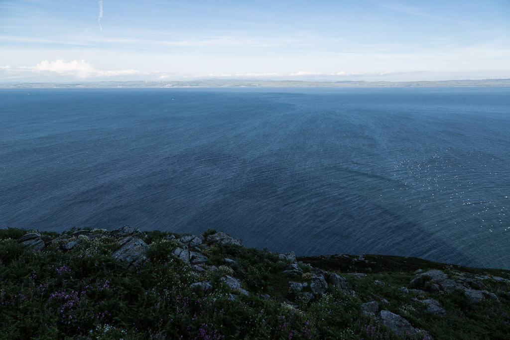
As we ascended we caught sight of the huge shadow cast by Ailsa Craig on the sea far below.

I feel behind the others again as we climbed the flower filled Garry Loo, a long depression in which the Garry Loch can be found in wet weather.

At last we broke into the sunshine at the summit cairn and trig point which is 340m above sea level.

We peered over the edge down to the lighthouse fro where we had started our climb. You can just see our tents by the corner of the lighthouse wall.

The seacat HSC Express roared past on her way from Troon to Larne.

It was good to take a rest on a rock. We gazed over towards Campbeltown where Tony and I had set off from 48 hours before.

This gannet swooped in from the direction of Mull of Kintyre and Sanda Island. Its belly was full of fish to feed its chick on the ledges below.

 To the north the whole of Arran was laid out before us.

Looking north past Holy Island we saw the southern edge of the highlands from Ben Ime and the Arrocher Alps to Ben Lomond.

 To the east the town of Girvan was backed by the Galloway Hills which are crowned by the Merrick.

To the north east we could see Turnberry Hotel and lighthouse, Culzean Castle and Mochrum Hill and the Carrick Hills rose beyond.