Monday, September 19, 2011

Sea kayaking to Shoe Bay, Eilean Shona.

 The south coast of Eilean Shona proved to be a wild place with wooded islets and...

...rocks plunging straight into the waters of Loch Moidart. The transition of colours from the forest above to the sea below was very pleasing.

I slipped through rocky channels, where an otter was my only companion, while Donald kept well out into the deeper water of the South Channel.

At last I spotted a sliver of silver sand cutting through the grey rocks.

Donald took a longer way round.

We had arrived at the beautiful tidal inlet of Shoe Bay. The sand here is very soft and so has claimed many a shoe! We didn't dally long, as the tide was dropping fast.

We now left Loch Moidart and turned north up  Eilean Shona's even wilder more rugged west coast. Huge boulders have tumbled from the cliffs into the sea.

Sunday, September 18, 2011

Gracious living in Loch Moidart...but bring your own cook!

Our journey by motor boat and kayak continued. The south channel of Loch Moidart is guarded by...

...the grey walls of Castle Tioram (pron. cheerum), which sits on a tidal island on the south shore. It was the ancestral home of  Clan Ranald from the 14th century. The family owned the castle until the early 20th century, though it has been a ruin since  the early 18th century. The castle currently belongs to a Scottish businessman, Lex Brown, who has been in a long battle with Historic Scotland to restore the building to a habitable state. Unfortunately a 300 year battle with the elements means that the castle will need a bit of doing up!

To the NW of the castle there is a delightful beach upon which we...

... alighted to partake of a second breakfast.

We enjoyed a peaceful exploration of the castle's policies, undisturbed by the many tourists who were waiting in their camper vans for the tide to drop, before invading the island via the tidal causeway that connects it to the mainland.

As the tide continued to ebb, we made our way across the south channel to Eilean Shona where we explored the...

 ...the bay, behind which Eilean Shona House nestles, deep in the woods.

In the 1920's JM Barrie rented Eilean Shona and wrote the screenplay for Peter Pan on the island. Nowadays it is possible to follow in Barrie's footsteps and rent Eilean Shona House for a holiday but, you are advised to bring your own cook (who can stay free in the room provided).

Saturday, September 17, 2011

The islands and channels of inner Loch Moidart

Rounding the east end of Sona Beag we allowed the ebb tide to carry us towards distant Tioram Castle. The source of the smoke we had seen earlier was on Riska Island and I wondered if our friends over on Song of the Paddle were camping there with a pot bellied stove!

 Loch Moidart has many delightful wooded islands of all sizes, from the very small...

 ...to the slightly bigger.

Donald stuck to the deeper water along the southern shore...

...but I slipped through the most ridiculously narrow channels  round Eilean an Fheidh.

 Drifting along in this fantastic spot was...

 ...like waking from a dream, sometimes it was difficult to separate reality from fantasy.

As we approached Riska Island, we heard a chain saw working hard. I still thought it was a party of open canoeists. It's quite amazing what they carry in those boats! However, it proved to be forest workers clearing that plague of the West Highlands... the rhododendron.

Friday, September 16, 2011

Noisy children banished in Loch Moidart.

Once we had entered the North Channel of Loch Moidart, we came across a substantial Victorian house nestling in a little north facing valley on Eilean Shona, the island which sits in the mouth of Loch Moidart.

It is Baramore school house and at one time about a dozen children were taught there. It is built on the opposite side of Eilean Shona from the other houses, reputedly because the wife of the island's owner did not want her peace to be disturbed by children! In August the purple heather and green bracken created lovely reflections on the still water but the hillside was silent. The children are long gone.

At the north end of Eilean Shona, a narrow neck of land joins it to the smaller Shona Beag. In the distance a wisp of smoke rose lazily in the still air. In the shelter of Loch Moidart, maritime forests of oak come right down to the sea shore.

As we made our way past Shona Beag, the view was dominated by the mist shrouded slopes of Beinn Resipol 845m, in the lands of Sunart.

We were now in a tidal channel, which dries to reveal a ford at low tide, Donald wound his fishing lines in but he still had 3m of water under his keel as it was high water.

Just as the ebb tide turned against us, we approached the east end of Shuna Beag and prepared to turn west, to continue our exploration of beautiful Loch Moidart.

Thursday, September 15, 2011

Going to work on an Eigg but treading carefully.

Neither Donald nor I slept well and we both rose early. Donald had slept in the boat with the cover on. He awoke to find he was getting wet from the condensation dripping from the cover. He then opened the cover, only to be eaten alive by midges. My problems were different, I had pitched my comfortable tent on some delightful machair but the pain in my knee was so bad that I hardly slept a wink. However, emerging into the still air of the morning with a view like this, over to the Small Isles of Muck, Eigg and Rum, was worth a sleepless night. After a hearty breakfast of bacon eggs and Cox-2 inhibitors we...

...set off an hour before high water and turned our backs to the open sea and Eigg, as we wanted to work our way, treading carefully, through the rock strewn North Channel of Loch Moidart.

From the sea it is quite difficult to spot the entrance...

...and once in, you find the tortuous channel is littered with rocks. Many were barely covered by the big spring tide.

I was quite happy to scrape over the occasional rock in my kayak but Donald needed to be a lot more careful in his boat.

Then we were in and the North Channel stretched away to the misty mountains of Moidart.

Wednesday, September 14, 2011

High and dry at day's end in Moidart

We landed on a shell sand beach in the lee of some skerries on the Moidart coastline. We had travelled so far south that Rum now lay behind Eigg on the horizon.

Donald's boat and engines are heavy but high tide was about 8pm and as we intended to launch about 8am the next morning, no hauling up the beach was required. I think I will stick with a sea kayak though!

As the sun set behind the Sgurr of Eigg...

...and as the receding tide left Donald's boat high and dry, we lit a fire on the beach.  A bag of barbecue charcoal always makes a good heart for a fire and I had also bought a sack of logs from a petrol station on the road north to Arisaig.

Donald and I reminisced and put the World to rights as our baked potatoes (in tin foil) roasted on the fire...

Tuesday, September 13, 2011

A bumpy crossing of the Sound of Arisaig.

From Port nan Murrach, we pointed our bows to the east. We didn't bother exploring Port a' Bhathaich as it is a trap for most of the flotsam and jetsam in the area.  Instead, we cut across its mouth and slipped inside Eilean a' Ghaill. It has the remains of a vitrified Iron Age fort on its summit. There is a great view from the top but it is a very steep scramble and although it is only 23m high (and in 2004 I almost skipped up), I knew that as far as I was concerned it could now just as easily have been the Inaccessible Pinnacle on Sgurr Dearg in the Cuillin.

We now had  a choice, head up into Loch nam Uamh at the head of the Sound of Arisaig staying in the shelter of the lee of the Arisaig peninsula...

Photo by Donald Wilcox
 ...or head straight across the mouth of the Sound of Arisaig for the distant lands of Moidart. Well it was a no brainer, it was a broad reach on open water all the way to Moidart! At first the sea was nice and flat due to the shelter of Rubh Arisaig...

...but it got a little bit bumpy on the crossing especially  as we approached the wind over spring tide conditions off 
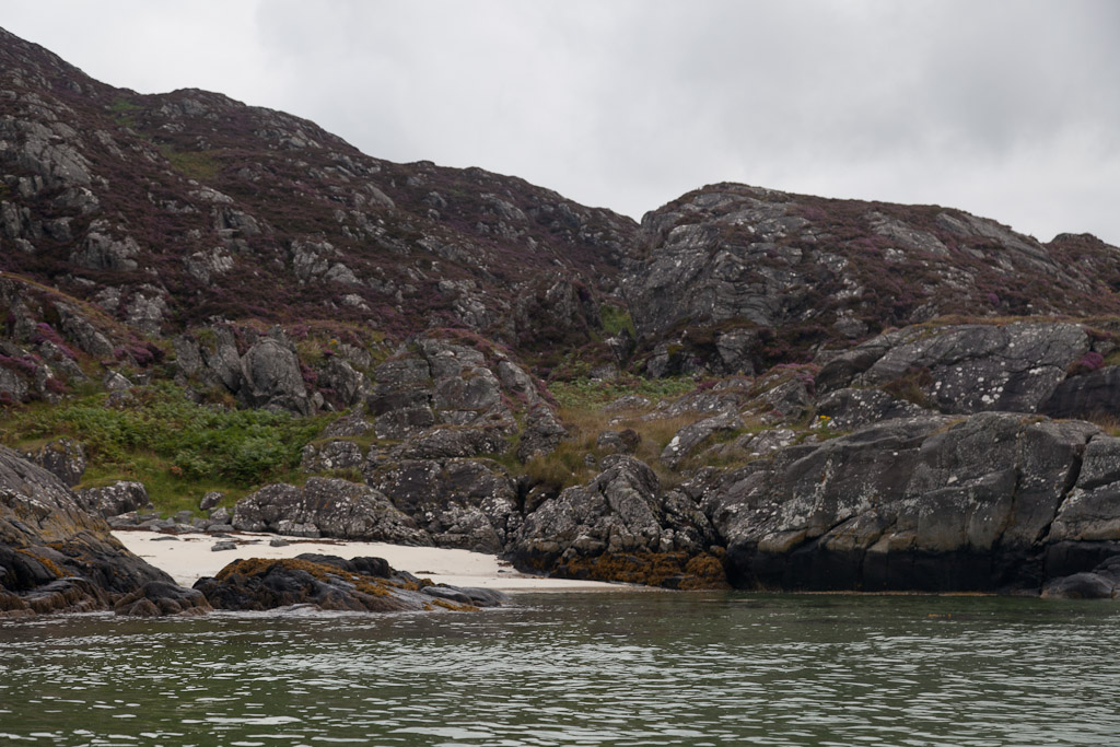
Rubha Ghead a' Leighe.  Photography stopped until we were well down the Smirisary coast and the water flattened again as in the photo above. Smirisary was a crofting community that survived until the end of the Second World War when it was abandoned. Nowadays, many of the old crofts have been restored as holiday homes.

It was too rough to land on the rocky shore at Smirisary and anyway we still had a way to go before we could finally pull up the boats on another shell sand beach.