Showing posts sorted by relevance for query "02/06/2008". Sort by date Show all posts

Thursday, July 03, 2008

Sea kayaks are go on Hirta Island!


By now it was nearly 4pm on Monday. Unfortunately the promised light winds for Tuesday were lost in the gloom of the most recent forecast: force 5 southerly this evening increasing force 6 southerly by morning. It was make or break time, on St Kilda calm conditions never last long. Murdy considered the options then came the call. "Launch the boats!" Raiding Vikings could hardly have got on the water so quickly! Murdy's plan was to paddle round Hirta anticlockwise. This would mean we should arrive in the Hirta Soay gap about slack water. The only problem might be an increasing southerly shrieking through the gap. Murdy arranged for Cuma to rendezvous with us at the gap. Cuma would then go through as a probe!


The tour boats were all moored in a neat line across Village Bay, very shipshape! But wait....


...that red boat doesn't look very neatly parked!

02/06/2008

Friday, July 04, 2008

Better Days: the wreck of the Spinningdale


As we left the Cuma, on the start of our great St Kilda adventure, we were so excited. As we left Dun behind us and headed across Village Bay the wind dropped to nothing .


Our first destination was not to be some geological wonder but a rather poorly parked fishing boat, the FV Spinningdale.


Over the night of 31/1/08 and 1/2/08 she sought shelter in Village Bay in a NW gale. The sea conditions meant she could not anchor and she motored slowly against the wind trying to maintain her position throughout the night. Unfortunately vicious down draughts from the mountains above slewed her onto the rocks at the edge of Village Bay. The conditions were so violent that the crew could not launch the life rafts and she put out a Mayday.

At first the Stornoway Coastguard S92 helicopter and the Stornoway lifeboat were both launched. Remarkably, the helicopter managed to winch all 14 crew to safety and the lifeboat turned back.

The picture of the Spinningdale in the shore break is by an MCA coastguard photographer and given to me by Murdy Campbell, cox of the Stornoway lifeboat.


It was humbling to paddle round the sad remains of the Spinningdale and realize that we were now in some of the wildest and remote waters in the UK.

02/06/2008

Sunday, June 08, 2008

Murty Campbell


Murty Campbell is one of the great sea kayaking pioneers. Over a decade ago he completed unsupported crossings to isolated Hebridean outliers such as St Kilda, Sula Sgeir and North Rona. Murty has a quiet unassuming manner which belies his experience of the sea, first of all in the Merchant Navy then as cox of the Stornoway lifeboat and as a sea kayaker.


Murty leads a group through the great tunnel of Geodha na h-Airde on the north coast of Hirta. St Kilda lies 67km (42 miles) off the west coast of North Uist in the Outer Hebrides.

His prescence on the water gives an air of quiet confidence which helps less experienced sea kayakers push their own previous boundaries. The fact that a party of twelve sea kayakers (of mixed ability) paddled right round Hirta in the St Kilda archipelago was entirely due to his leadership.

02/06/2008

Wednesday, July 09, 2008

Purty sea kayaks and the great tunnel of Geodha na h-Airdhe, St Kilda


Geodha na h-Airdhe is a 140m long tunnel right through the great headland of Gob na h-Airdhe on the north coast of Hirta in the St Kilda archipelago.

Alan comes through in his Nordkapp LV. I think this boat is one of the purtiest sea kayaks around!


Fiona F and Murty come through as the MV Cuma makes an appearance behind.


The scale of this arch is difficult to describe, in truth it is a tunnel!


Yup the Nordkapp LV sure is a purty boat. Pity the same can not be said of all those who paddle one! Photo Jennifer Wilcox.


With Boreray as a backdrop to the NE, Lena and Jennifer paddle across the great sweep of Glen Bay where we had arranged to rendezvous with the Cuma.

The Cuma's purpose will be revealed tomorrow...

02/06/2008

Wednesday, October 01, 2008

The south west coast of Dun, St Kilda archipelago.


We emerged from the darkness and enclosure of the caves of Dun and found ourselves once more with the empty Atlantic horizon to the south west.


We paddled under Dun's sheer cliffs and made for the stack of Sgeir Cul an Rudha.


Above us thickening cirrus clouds announced the arrival of a front and the promise of wind by morning.


We were still in awe of the sheer scale of the rock architecture of these islands.


Squalls of wind gusted between the stack and Dun.


We rounded the great headland of Giumachsgor and there before us, lay the portal of the Great Arch of Dun!

02/06/2008

Monday, June 30, 2008

Anchors aweigh for St Kilda!


On the morning of 2nd June the day had dawned fair and Murdani, the Cuma's skipper weighed anchor for St Kilda!


Soon the low lying dunes of the Monachs were slipping over the horizon astern and only the lighthouse marked their location.


Ahead of the Cuma lay 66km of the open Atlantic Ocean before she would make landfall at St Kilda. Unlike the low lying Monach Islands we had just left, the soaring cliffs and stacks of the St Kilda archipelago form the highest and most stunning sea cliffs in the British Isles.

Even today it is one of the most difficult parts of the British Isles to reach. Although it was midsummer there was no guarantee we would get there. We knew this only too well. Almost exactly two years ago we had had to turn back. We were aboard a 70 foot converted trawler, the MV Dundarg. A force 9 storm swept in off the Atlantic, forcing us to take shelter in Loch Reasort on the west coast of Lewis. The wind was so strong, Dundarg dragged her anchor all night.

Amazingly, despite the difficulty getting there, St Kilda was inhabited for about 3,500 years, until the islanders abandoned her in the 1930's. St Kilda captures the imagination not just because of its unique location and geology but because of the indomitable human spirit of the generations of islanders that survived on her remote and windswept slopes.

02/06/2008

Tuesday, October 07, 2008

Dun roamin', the return to Hirta.


Emerging from the Great Arch of Dun for the last time, we headed for Village Bay on Hirta. It was 21:30, the end of a fantastic day.


As we paddled under the ramparts of Dun, showers of puffins emerged from their burrows and launched themselves over the cliffs to splash into the sea around us. Photo JLW.


Finally we landed on a small sandy beach revealed by the low tide. We had finally circumnavigated Hirta and landed on Village Bay!

02/06/2008

Monday, July 07, 2008

Sea Kayaking St Kilda: the north face of Conachair and Bradastac


As we made our way anticlockwise round the north coast of Hirta we were completely overawed by the scale and wildness of this place.

Bradastac lies at the foot of the highest sea cliffs in Britain. Anywhere else it would be a giant amongst stacks. Here it was dwarfed by Conachair just as we were dwarfed by it.


We made our way round Bradastac as the swell slowly rose then fell round its red rocks.


Fiona F with Bradastac and Mina Stac in the distance.


Bradastac, with Fiona F, Alan and Clark below the stunning cliffs of Conachair, the highest mountain on Hirta.

02/06/2008

Friday, December 19, 2008

End of the road: the Mull of Galloway tide race.


After we reloaded the kayaks onto the car, we drove to the road end at the Mull of Galloway, the southernmost tip of Scotland.


Looking east on the spring ebb tide you can see the main race comes very close to the east end of the Mull but it then heads SW, out to sea, leaving most of the cliffs below the Mull standing in a relatively flat eddy.


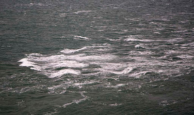
This is the spring ebb race running against a force 4 to 6 SW wind.


Looking south towards the Isle of Man over the ebb race.


Looking west, the ebb race is well offshore...but the water round Gallie Craig is not exactly flat.


To give an idea of the scale this is Gallie Craig from the sea looking east towards the lighthouse! (17/02/2008)


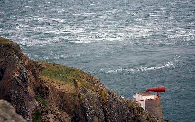
The above photos show the ebb race. The flood race come much closer to the cliffs than the ebb. We went through against the flood tide, 2 hours from slack water at springs. This photo (in a similar wind to that which we experienced) shows the water state below the fog horn, 2 hours from slack water at neaps. It gives an idea of what we met. We found more broken water and the conditions persisted without a break for 2km! To give some idea of scale, the photo was taken from a height of 71m. (28/12/06)


Going east to west, on the west going ebb you have only a short 100m or so of race to cross at the east end of the Mull. After this you enter a large relatively flat eddy which extends right to the west end of the Mull and beyond.

Going east to west on an east going flood as we did, even in close to the rocks, you are much closer to the main race. From the light house you have to fight adverse currents at each headland. The red arrow highlights a submarine reef which throws up standing waves especially on the flood.

What a fun place! No wonder several legends attach to this place.....

PS Of course most people would have driven up to the road end at the top of the cliffs and looked at the race before they paddled it. Many would have decided that one look was enough! The trick with this type of paddling is not to look first! We didn't, but of course I am not recommending this ostrich type of approach to planning sea kayaking expeditions! In truth I knew exactly what it would look like as I have gazed down on the race in many different conditions but not paddled it afterwards.

15/12/2008