Wednesday, June 10, 2009

Days like these...


This yacht was visiting the Solway from the Isle of Man. Early the following morning, she hoisted her jib, then her main and lifted her anchor all in one smooth motion then slipped away on a broad reach to the Isle of Man.


It is always a pleasure to see a ship shape, well handled yacht when nowadays the majority stay in the marina or only venture out with the motor.


I drifted for some time on the ebb tide...


...but all too soon I had to break the glassy calm and my paddles drove me against the gathering current between Ardwall Island and the mainland.


As I entered Fleet Bay, the last of the sun slid towards the dark granite slopes of the Galloway Hills.


The sea turned to gold and ebony as the last gasp of the day slipped away with the ebb tide. Even the shrill pipping of the oyster catchers fell silent. I paddled home in the silence and the night gathered round me.

What would tomorrow bring?

31/05/2009 pm

Kayak Caledonia progress report #11

Day 20, 10th June:

17:20 Tony: "We are just through the Corran Narrows on Loch Linnhe. We had to battle against the wind the whole way down the loch. Loch Ness and the Caledonian canal were really lovely. We had a tailwind most of the way and surfed down Loch Ness at 12km/hour.

Tomorrow we hope to get through the Sound of Mull, then round Ardnamurchan on Friday and finish at Morar on Sunday!"

Tuesday, June 09, 2009

End of another Solway Day


As I was leaving Meggerland Point, I caught a glimpse of light at the back of a geo called rumblekirn.


I could not resist exploring and I discovered a small cave with turquoise waters and a blow hole at the back.


I now made for the Sw corner of Barlocco Isle.


Rounding Barlocco, I now turned towards Ardwall Island as the sun dipped towards the horizon.


As I neared Ardwall I came across this beautiful yacht lying peacefully at anchor, her bow towards the ebb.

31/05/2009 pm

Sunday, June 07, 2009

A Solway sunset swim


After my visit to the stack and caves, I returned to the little beach below Meggerland Point. As I my way through the skerries, I floated over cobbles, which shimmered in the ripples of the crystal clear water.


I couldn't resist a second swim in this beautiful spot, as the sun sank gently to the west.

31/05/2009 pm

Saturday, June 06, 2009

Kayak Caledonia progress report #10


Day 16, 6th June 24km

21:30 Tony: "We are in Rockfield at the mouth of the Moray Firth. We didn't launch till 2:30 by which time the sea and the wind had settled. We used the morning to wash and dry all our stuff in the campsite laundry. The Fourth Element Thermocline stuff has proved really good. It was a long grey crossing direct to Tarbart Ness from Brora. The wind had dropped to force three but it was still very cold.

Once round the Ness, into the Moray Firth, we could see snow on the Cairngorms. Its a very rocky coast but we landed at the jetty in Rockfield. A man was sitting in his garden and suggested we camp on his lawn! We are just back from visiting the pub in Portmahomack. We didn't stay long as a bunch of young locals seemed intent on a swally race. We thought discretion was best and made our exit.

Tomorrow we hope to get round Chanonry point and camp at Fortrose."

The caves and stacks of Meggerland Point


I was pretty hot and bothered after climbing all over Castle Haven so I went for a refreshing swim in a tiny cove below Meggerland Point. I then continued east below the heughs (Galloway for cliffs). Rounding a corner I nearly missed a cave in the shadows cast by the setting sun.


I am glad I didn't because it is one of the best caves in these parts. There was some deep gurgling going on in the back of the cave...


...which was punctuated by a steady drip from somewhere in the darkness above me.


Continuing eastwards I threaded my way behind Meikle Pinnacle, an isolated stack.


I then came across Dove cave which can only be entered at HW springs. I just love the old man, a mimetolith which stands watch over the entrance.


The ebb was now well established and I was 8km from home so...


...I retraced my route in the shade of Meikle Pinnacle before emerging into the light of the setting sun.

31/09/2009 pm

Friday, June 05, 2009

The most southerly broch; Castle Haven


Last weekend it was neap tides on the Solway. HW here is always in early morning and evening with neaps and as the tide goes out a long way, mid day paddling is not possible from many of the bays.

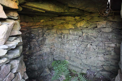
I set off at 5pm on Sunday evening and crossed the mouth of Fleet Bay. I turned into Castle Haven Bay as I know of a wonderful historic site at its head. Castle Haven is passed by by most people. Its wall grow out of the Galloway rocks but have become overgrown by vegetation. It is a D shaped broch or dun. These double walled dry stone structures were built up the west coast of Scotland and the Hebrides in the final centuries BC. Castle Haven is the most southerly example.


Dun Carloway in Lewis is perhaps the most famous. As the sea was the highway of communication in those days it is likely that the owners of Castle Haven and Dun Carloway knew each other even though they are 420km apart as the sea eagle flies. Perhaps they were even on first name terms!


The typical doubled wall structure of a broch is seen from the SWE corner...


... and more clearly in this aerial view from the scran website.


Most brochs are circular but Castle Haven's west wall is straight as it follows a low line of cliffs, which drop to the bay below. The resulting enclosure is D shaped.


The quality of the interlocking stone masonry has survived two millenia. Unfortunately most of the upper structure has been raided to build some of the many 18th and 19th century drystone walls which criss-cross the Galloway countryside.


After a very pleasant exploration of this fascinating structure I made my way back down the stone steps to the sea gate and the bay below.


White campion flowers adorned the rocks below the castle walls. I returned to my kayak and paddled on in the evening sunshine.

31/05/2009 pm