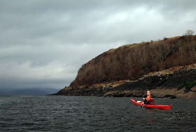
Imagine you are at the edge of the sea on a day when it is difficult to say where the land ends and the sea begins and where the sea ends and the sky begins. Sea kayaking lets you explore these and your own boundaries and broadens your horizons. Sea kayaking is the new mountaineering.
Friday, August 07, 2009
Eilean Munde, an isle in a Stygian situation.
Once through the narrows, we found ourselves in Loch Leven (Loch Leamhain or Loch of the elms).
As we paddled on we approached little Eilean Munde which nestled in a corner of the loch under the Stygian heights and recesses of Glen Coe.
Eilean Munde is named after St Fintan Mundus who founded an abbey here in the seventh century.
The island is also known as Eilean Nam Mairbh (Isle of the Dead). It has been used as a burial ground for centuries, the dead are carried over in a small boat.
As we approached, all was quiet and peaceful and even the wind died away.
28/02/2009
Thursday, August 06, 2009
Beauty and the beast at Ballachulish
We paddled towards the tidal narrows at Ballachulish which separate Loch Linnhe from Loch Leven to the east.
The narrows are now crossed by the Ballachulish Bridge which has been described as the most brutal bridge design in Scotland. Over the years I have grown to quite like it, here its girders contrast with the beauty of Sgurr na Ciche.
The bridge was completed at the end of 1975 but, before that, a vehicle ferry ran across the narrows from 1903. These were flat bottomed turntable ferries and used the slipways in the shallow water at either side of the narrows. One of the last of these ferries was the Glenachulish. She was built in 1969 at the Ailsa yard at Troon on the Firth of Clyde. She served the Ballachulish crossing until the bridge opened, then she was moved to Kessock and then Kylsku to serve as the relief ferry until those crossings were replaced by bridges in 1982 and 1984. After this she moved to Glenelg for the Skye crossing where she still serves today. The crossing at the peak of a spring tide always provided an entertaining ferry glide.
Not all crossings were entertaining. In 2003, Maureen Macmillan MSP recounted the following in a debate on the Scottish Railways and Transport Safety Bill: "The bill reminds me of an incident from my past involving the Ballachulish ferry on New Year's Day, a bottle of Chivas Regal drunk on the north side and a ferry that could not dock on the south side. The ferry went up Loch Leven and anchored and there was a stand-off with the police. Later, the Oban Times reported that someone had been charged with being drunk in charge of a ferry. The experience was frightening for everyone on board. "
I took this photo at Easter 1975, just as the last section was being lowered into place. You can just see the Glenachulish leaving South Ballachulish. She took 6 cars on her turntable which allowed a fast roll on roll off service. At peak periods two ferries served the crossing and the rule of thumb was, if there were more than 36 cars in front of you in the queue, it would be faster, but less fun to drive the 31km (19 miles) round the twisting, narrow road to Kinlochleven at the head of the loch and back down the other side.
Most of my generation, who spent time waiting for the ferry, appreciate the hidden beauty of this brutal bridge.
29/02/2009
Wednesday, August 05, 2009
An alluring view of a pointed breast and a thunderbolt!
After a brief stop at Rubh a Bhaid Beithe (point of the alluring beechwood), our course turned due east.
We now caught sight of Sgorr na Ciche ,the mountain which guards the west entrance of Glen Coe.
Sgorr na Ciche is Gaelic for "pointed peak of the breast". The Gaels are a poetic lot but they have a point.
To our south the ridges of Beinn a Bheithir (hill of the thunderbolt) rose into the clouds.
28/02/2009
Tuesday, August 04, 2009
Rain storms on the roof of Scotland.
We landed on an inlet on the west side of Eilean Balnagowan in Loch Linnhe to take advantage of a break in the rain. After an excellent luncheon, we set off to explore the island. A great deal of the hillside was covered by dense growths of brambles, which we thought would puncture our dry suits.
It was easy enough to cross the little isthmus that joins the two halves of the island. We emerged on a grassy bank behind the east beach. It Seems that the east beach belongs to the geese and the west to the gulls. The two species seemed to respect a line of demarcation that ran through the spine of the island. We saw no border disputes.
I have searched the Internet and a library of books but there is little mention of Balnagowan. Even the usually reliable Hamish Haswell-Smith dismisses it with a single mention in a sentence about a view to Ben Nevis. The only sign of antiquity was a low circle of moss and grass covered stones. It seem that poor wee Balnagowan was one of the few Scottish islands not to have been blessed by the presence of a resident Saint. Still, the staff of seakayakphoto.com have now enjoyed an excellent luncheon there!
With a following wind and gentle seas we made speedy progress across the mouth of Cuil Bay and up the coast of Appin.
Rounding a low point near Back Settlement, we gazed across the Loch to the shore side settlement of Onich and the mountains of Lochaber behind. In the distance the foothills of the Mamores were streaked with snow and disappeared into the clouds. Above their summits, lay the unseen roof of Scotland, Ben Nevis 1343m.
All the while our course was gradually bearing eastwards and as we approached Rubha nam Moine (Point of the Morass) more heavy rain showers came our way.
We were well past Rhuba Moine before the skies cleared again. I always think it is worth bringing a camera, even in bad weather. Clouds are very photogenic.
28/09/2009
Sunday, August 02, 2009
A sunbeam on Balnagowan
Heavy squalls of rain were driving up Loch Linnhe and hiding the mountains of Appin.
Then a chink appeared in the grey clouds...
... and a beam of sunlight fell on Eilean Balnagowan. A flock of black headed gulls wheeled in the sky round the isle. Their wheeling wings flashed white against the gloomy grey of the mist shrouded mountains.
The distant mountains of Lochaber and the Corran Narrows were calling us on to the NE but first it was time to take luncheon on this lovely isle.
28/02/2009
Saturday, August 01, 2009
Loch Linnhe and the Holy Grail
North of Lismore, Loch Linnhe stretches away to the NE. It forms part of the Great Glen fault that bisects the Highlands of Scotland.
We paddled NE past Eilean nan Caorach on our way to Shuna on which the crumbling remains of Castle Shuna stand at the edge of woods by the shore.
To our east, the much better preserved Castle Stalker stands on a small island at the entrance to Loch Laich.
Castle Stalker was built by the Stewarts of Appin in the 1440s. Over the years it changed hands with the Campbells several times on one occasion as a result of a bet. It was restored by a descendant of the Stewarts between 1965 and 1975. It achieved more recent fame as "Castle Aargh" in Monty Python and the Holy Grail.
Having visited these castles before, we made our way up the west coast of Shuna. Her lower slopes were hidden by the bare boughs of birch and alder.
28/02/2009
Friday, July 31, 2009
Save Sammy Seal
If you are a UK resident and think we should share the planet with the likes of Sammy Seal, please sign this petition which has been raised by Mark Carter.
'We the undersigned petition the Prime Minister to Stop shooting seals: British seals should have the same protection as dolphins and otters.'