Wednesday, March 12, 2008

The sun sets over Craignish; the cradle of the Scotland.


As we left the head of Loch Craignish, the road south climbed steeply up the Bealach Mor (the big pass). Before the road turned inland we enjoyed this amazing view over the loch to the ridges of Craignish and to the rocky outlines of Jura and Scarba beyond. The lights of Ardfern twinkled in the shelter of Eilean Mhic Chrion.

Craignish lies in the parish of Kilmartin which is the first village to the south of the Bealach Mor. This area of Scotland has been settled for over 4,000 years, since Neolithic times. In the vicinity of the village there are over 350 ancient sites within a radius of 10 kilometres. Not for nothing, is this area known as the Valley of Ghosts!

Much later, about 400AD, the Scots who lived round the coast of this part of Argyll, Kintyre, Islay and North Ireland, founded their kingdom of Dalriada here. Their capital was Dunadd fort which was built on a rocky outcrop. This rose from the Great Moss, the flat land behind present day Crinan. Gradually their influence extended throughout the rest of Scotland. The first King of all Scotland was Kenneth Macalpine, he was crowned at Dunadd in 843AD.

12/02/2008

Tuesday, March 11, 2008

Better Days


We came across this old fishing boat near the shore of Loch Craignish. The flaking paint of her planking glowed in the twilight and brought colour to the waters of the loch that once supported her. She is alone now and her days at sea are past but she is decaying with a dignity that befits a craft that in turn supported a way of life.

Boats like this can be found in quiet corners all round the West coast of Scotland. They are a dying breed; built of wood by local craftsmen (this one perhaps in the boatyard at nearby Crinan) they sometimes served several generations of one fishing family. I wonder if the men who fished from her are still working or have long since retired. They too are a dying breed.

We left her in the gathering darkness of Craignish.

12/02/2008

Monday, March 10, 2008

Sunset over the Enchanted Mountain.


From Craignish Point we looked southwest down the Sound of Jura and we watched the deepening twilight gather behind the rugged Isle of Jura. Long after the sun had set, the dreamy, dusky light on the distant Paps of Jura was worth the wait and the cold! It emphasised the mystical nature of these mountains; Beinn Shiantaidh (on the left) is Gaelic for Mountain of the Enchantment.

12/02/2008

Sunday, March 09, 2008

Winter twighlight on Loch Beag


Loch Beag is an inlet off the Sound of Jura. At its head, surrounded by woodland, is Craignish Castle. The Castle dates from the 16th century and the original square keep has walls 7.5 feet thick. A dungeon has been cut into the rock below its foundations. Nowadays it has been converted into private apartments and it is not possible to visit it.

Loch Beag is still a secondary tidal port, perhaps reflecting its previous importance as the Craignish ferry terminal.

12/02/2008

Saturday, March 08, 2008

The ferryman of Craignish


In this house lived the ferryman of Craignish.

According to the 1881 British Census, his name was Dugald Mc Farlan. He was aged 60 and lived in the house with his wife Anne aged 36 and their children Dugald 12, scholar, John 8, scholar, Margaret 6, scholar and Malcolm 4. Dugald's sister Anne 52, Handicap: Lunatic and John Mc Vicar 19, assistant ferryman also lived in this little house.

The house was not shown on the Ordnance Survey map of 1875 so it must have been built between then and 1881. Despite the overcrowding by modern standards, they probably had one of the best houses on the peninsula.

12/02/2008

Friday, March 07, 2008

The sun goes down on the last ferry to Jura.


As the sun set on our Dorus Mor adventure, we returned to our launch spot, the old Craignish Pier.


There had been a ferry running between Craignish and Kenuachdrach (now Kinuachdrachd) on Jura since the 17th century. According to the statistical account of Scotland of 1843, 3,000 sheep and 1,000 black cattle were shipped through here each year.

The present pier is not shown on the 1875 Ordnance Survey map butthe 1881 British Census records the ferryman's cottage as being occupied. The 1900 Ordnance Survey map does show the pier as a T shaped structure. Presumably the top of the T was made from wood, as no trace of it remains today.


You still can walk to the end of the pier to watch the sun go down over the Sound of Jura and the Gulf of Corryvreckan but you will wait a long time for a ferry. The last ferry left in the 1930's.

Nowadays Jura has no direct ferry link with the mainland. You need to take a ferry to Islay, get off then take a smaller ferry from Islay to Jura. Jura is a remote and wonderful place, you would be quicker going by sea kayak!

12/02/2008

Added 08/03/2008

PeterD said...
that pier looks very tall - how did you land here? Is there a beach nearby you could land at?

Peter there is a small beach about 500m further back on the single track road that ends at the jetty. Unfortunately there is no car park there. In dry weather it might be possible to park on the verge but it was too boggy when we were there. We carried the kayaks down the steep slippery rocks to the right of the pier.

Thursday, March 06, 2008

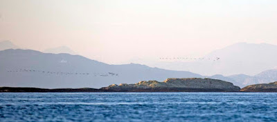
Barnacle geese on an early passage north through the Sound of Jura


We finally broke out of the current that was flowing from the Dorus Mor relentlessly towards the gaping jaws of the Gulf of Corryvreckan beyond.


We were now heading north west with the rocky isle of Reisa Mhic Phaidean on our left. All day long, we had watched great skeins of barnacle geese flying north up the Sound of Jura from their wintering grounds on Islay.

They spend the summer on Spitzbergen, some 2700km away to the NNW. I do hope they were not fooled into an early departure by that glorious high pressure spell in February. They normally leave in April and the severe weather since mid February must have made a northward migration almost impossible.

Beyond the geese, you can see Kilmory Lodge on Scarba and the distant mountains of Mull.

12/03/2008