Friday, April 06, 2007

The Weatherman.


They don't call me The Weatherman for nothing you know!


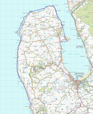
Despite all odds, today Tony and I spent our third consecutive paddle completing the last section of the 85km round of the Rhinns of Galloway. It is a remote peninsula washed by the tides of the North Channel that run at up to 5 knots in springs. There are few places to land.


When we arrived at Killantringan Bay there was some pleasant surf which delayed our start as we just had to do several runs! A big dumper carried away one of my splits but Tony recovered it. Unfortunately another dumper got Tony but he rolled up nae bother. Despite being a bit damp, he carried on with no complaints.


We decided to press on...


...but were diverted by another surf beach.


Fortunately all this delay let the spring ebb pick up and it shoved us along at a fair rate. Just as well really, this was a 31km leg. At the north end of the peninsula a force 4 wind was running againt the ebb, what with the swell as well, it was quite a bouncy trip so there are few on the water photos. Even though it was Good Friday we did not see any other sea kayaks or even fishing boats. All we saw were ferries leaving Loch Ryan.

The Rhinns of Galloway; what a location and I doubt many have paddled it. Isn't seakayaking great?

Wednesday, April 04, 2007

Glorious Galloway #3


Yet another cave on the Rhinns of Galloway.


Dunskey Castle was built in 1510 by Adair of Kilhilt. It fell into the hands of the Blair family but was a ruin by 1684. They built Dunskey House in 1706 as a more comfortable replacvement.


Tony surveys the attraction of the Crown Hotel in Portpatrick. (The building with the red sign.)


End of a perfect day.

Tuesday, April 03, 2007

Glorious Galloway!


The Rhinns of Galloway really are superb. We launched from Port Logan in the lee of its ancient jetty. In the excellent Scottish Sea Kayaking, Cooper and Reid recommend launching from the fish pond car park which is marked on the map at 096104 (I presume they mean 096410) but access to the beach from here is down a steep wooden staircase with a right angled bend. I would suggest launching from another car park which is not marked on the map but is right beside the beach, 094404, in the shelter of the quay.


Approaching the Mull of Logan you will hopefully find yourself in the strong push of the tide. If not, you might need to brush up on your tidal planning. Close inshore, the north going ebb starts 3 hours before local high water at Portpatrick.


The Mull of Logan is riddled with caves, stacks and channels. It is easy to lose sight of your friends in the maze.


As you can see, David had an enjoyable swim in a cave. A swell shoved him in sideways till his bow and stern got jammed on the narrowing sides. When the swell receded he was left momentarily hanging, until gravity exercised its inevitable effect. A Palm Stikine dry suit and Fourth Element Xerotherm Arctic under suit meant that his swim in 9 degree Celsius water was a jolly jape and not a serious incident. This happened just 3km into a 27km day but it did not spoil our day.


In fact we spent so long exploring the Mull of Logan's fantastic arches that the tide turned against us for the last 7km.

The Rhinns of Galloway has tides with overfalls, surf beaches, rocky coves, caves, arches, isolation, ancient castles, quaint harbour villages and towns. It even has excellent sea kayaking pubs and ice cream shops. Tony and I have paddled extensively on Scotland's west coast. A lot of Scottish sea kayakers would say the Garvellachs area is their favourite, but this coastline really beats the islands of Lorn. Paddle it before the crowds arrive!

Sunday, April 01, 2007

The Amazing Rhinns of Galloway


One of several Mull of Logan arches


Yesterday we explored another part of the Rhinns of Galloway coastline, which is washed by the powerful tides of the North Channel which separates Scotland and Ireland. It was one day before maximum spring tides so there was considerable disturbance round the headlands.


Surfing into Ardwell Bay


Portayew Bay


We passed several bold headlands with tidal races; Mull of Logan, Money Head, and Black Head (above).


Just one of innumerable caves.

We left from Port Logan and headed north west to Killantringan Bay to the north of Black Head. We had amazing rock hopping amongst a maze of stacks and skerries and some of the most perfect arches and caves I have found anywhere on the west coast of Scotland. We passed deserted beaches, ancient duns and castles and all in all had the most perfect day. I am amazed that there is so little mention of this incredible coastline in Scottish sea kayaking circles.

Brace-a-Float

Regular readers of these pages will by now know of my love for gadgets. Here is the latest to come my way for review. It was sent in by Mike Thomson of Scottish Paddler Supplies. The Brace-a-Float is designed to be a 21st century replacement for the humble paddle float. I have always been suspicious of all the faff of attaching a conventional paddle float to the paddle blade, then inflating it then getting yourself back in the boat then deflating it before you paddle on. The Brace-a-Float addresses several of these limitations and has additional functionality in that it can be used as a bracing aid and hopefully prevent a capsize in the first place. It is contained in a slim nylon covered sleeve that fits over the paddle shaft and while not being deployed is kept out of the way between the hands. There is a small toggle at one end and a sharp tug releases the gas stored in a small CO2 container.


My friend, Mike Marshall, inflates the Brace-a-Float.


Mike now slides the Brace-a-Float to the desired side. The Brace-a-Float engages with the rubber drip rings on the paddle shaft and it is now ready for use.


Easypeasy! You now have a stable platform which can be used to re-enter the boat after a capsize, to prevent a capsize or to give stability when photographing or fishing. There is a simple deflation valve which can also be used to inflate the Brace-a-Float if you have already used the CO2 cannister. The cannisters are cheap, easy to source sodastream cartridges.

Plus points:
Always to hand.
Easier to (re)deploy than a paddle float.
It works better than a paddle float.
It is more versatile than a paddle float.

Minus points:
It is less comfortable as a lunch time seat than a paddle float.
You cannot use it as an emergency backrest as you can with a paddle float.

Overall:
4/5 and the Brace-a-Float is highly recommended.

Tuesday, March 27, 2007

Ferry gliding in strong winds.

All good sea kayaking blogs should carry instructive posts on technique. Today I have decided to tackle the important skill of ferry gliding in strong winds. I hope I am not presuming too much in that at least some readers will benefit from my experience of this issue.


On Sunday David and I went to Loch Fyne. I was a bit tired after a 30 km paddle round the Mull of Galloway the previous day. There was only two of us, so we took the Aleut Sea II double. Normally people don't come with us if we take the double as it can be quite fast.

It was quite breezy with a force 5 to 6 SE wind blowing up the loch. We pottered around in the shelter of the east side of the loch. There was a lot to keep us occupied, a vitrified fort, an old jetty, lovely sandy bays backed by indigenous woodland, little islands off shore and the biggest man made hole in Europe (830,000 cubic metres). We stopped for several luncheons, the last at lovely Ascog Bay but then I got a bit bored.

Looking out into the loch I noticed the wind and the driving waves heading straight downwind towards Tarbert. Goodness me, Tarbet has pubs and an ice cream shop! Then I remembered a chat with the guys from Stornoway canoe club. They are right into paddling downwind in the long sea Lochs of Lewis. A cunning plan was therefore hatched; to partake in some refreshment and gelati at Tarbert.


It was quite breezy and we covered the 8km at an average speed of 10.6km/hr with a maximum speed of 16.9 km/hr. The photograph does not really do justice to what the sea felt like. Despite paddling downwind, our paddles were being snatched by the wind. The waves were short and steep and did not seem to fit the length of the Aleut very well. One moment I would be surfing with free air under my seat in the front cockpit. The next the bow was buried up to my spraydeck with the rudder trying to get a grip in the air. With the boat threatening to broach we had to paddle like.... well vigourous sweep strokes were required!


I was quite tired by the time we got into the shelter of Tarbert.


Suitably refreshed we thought we had better make a start on the return journey. I noticed that the wind had now backed round to the east and was now straight in our teeth for the crossing back to Portavadie.
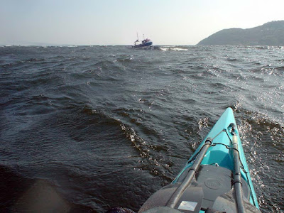


Paddling out of the shelter of East Loch Tarbert I noticed the line of breakers out in Loch Fyne. I also noticed the fishing boats were all returning to port. To make matters worse, paddling at full speed we could only make just over 2km/hr and that was before we hit the waves out in Loch Fyne. I stopped paddling to take the photo above and the wake shows we were going backwards despite the fact that David was still paddling like... well quite hard. A near 3 hour crossing at the end of a tough weekend's paddling did not hold much attraction. Then I saw a ship! A new plan, we turned our bow back towards Tarbert....


We had a very pleasant ferry glide home on MV Loch Riddon.

Monday, March 26, 2007

A perfect day to end up in 2000 Acres of Sky.


On Saturday we paddled to Port Logan, which featured in the BBC series "2000 Acres of Sky". The series was based on a fictional and remote island community called Ronansay which lay off the west coast of Skye.

Port Logan was originally called Port Nessock and in the 17th century attempts were made by the McDouall family to establish it as a ferry port for Ireland. They also built the Port Logan Inn which now makes a fine sea kayaking pub. (See here for what makes a good sea kayaking pub.)

The quay and Port Logan Light were built in 1830 by Colonel Andrew McDouall. The light is a conical stone tower with a platform for a lantern. It is not known when it was last lit but for sometime after that it had a bell, which was rung to guide local boats back in foggy conditions. A decent road to the village was not constructed until the early 20th century, so most of the village's trade and traffic depended upon the sea. A life boat station was built at Port Logan in 1866. It closed in 1932 as the RNLI lifeboat at Portpatrick, 18km to the north west, was motorised by then. The boat house is now the village hall which you can find near the quay.


We set off from Drummore and so had to pass one of the great headlands on mainland Britain. The Mull of Galloway is the most southerly point on Scotland. It juts into the Irish sea separating the Solway Firth from the North Channel between Scotland and Ireland. We were prepared for the strong tides and magnificent caves. What we were not prepared for was the stunning cliff coastline north west to Port Logan.

17/04/2007 lv asked "Do you have a panoramic photo of Port Logan?"

I do but it was shot in pretty flat light so it is not the best. Here it is...


I do not know where you stay but if you get the chance, you should visit Galloway. It is a wonderfully unspoilt region.

Sunday, March 25, 2007

What a difference a day makes.


Yesterday we enjoyed sun and light winds rounding a major headland. Today when the clouds cleared and the sun came out, it brought a fresh SE wind. It funneled into the mouth of Loch Fyne in the Firth of Clyde. We paddled out into the middle of the loch where the wind and waves were at their best.


David in the Aleut Sea II


Then we turned downwind for a 6.5km blast to Tarbert with its ice cream parlour and the pub.

All in all, a pretty good weekend

Saturday, March 24, 2007

Rainbow rock


Earlier today


A clue to rainbow rock's location. This cave is directly below one of the most prominent lighthouses on the Scottish mainland.

Wednesday, March 21, 2007

An Orange future for Barra and Vatersay but not for me.


This photo is of red haired, celtic cows on Bagh a Deas on Vatersay, the most southerly of the inhabited isles in the Outer Hebrides. It is especially for Michael, Hayden and Wenley and is one of a series of sea cow photos I am posting on this site.


On sea kayaking trips to the Outer Hebrides I usually take three PAYG SIM cards for O2, Vodaphone and Orange and I usually get mobile phone reception in most places but until now, not on Barra or Vatersay.

However, Orange recently started work constructing mobile phone masts on Bruernish and Bentangaval. It was hoped the network would be available from 09/03/2007. The mast at Bentangaval will also be used for the deployment of services provided by Connected Communities Broadband to create a wireless Internet network on the island.

The future might be Orange for Barra but not for Newton Mearns on the south of Glasgow. On 17/1/2007, as a result of local loop unbundling (LLU), Orange installed their own ADSL broadband equipment to replace equipment they had rented from BT. Since then my broadband has been just about unusable with download speeds of about 100 kbps (instead of the theoretical maximum of 6,500 kbps) and frequent drops of the connection. After much frustration, yesterday I requested my MAC code to transfer to another ISP. I will not be going to one of the free bundles with other services such as Sky satellite TV. I will be happy to pay for a decent reliable service.

Tuesday, March 20, 2007

Bag, a deer.


Kinloch Castle on Rum was built as a shooting lodge. It is full of stuffed things that once flew, ran, crawled or swam.


Its shooting books record days of hunting. On September the third 1925, Sir George Bullough killed a 7 point stag weighing 14 stone and 4 lbs on Kilmory hill with a 0.303 inch rifle. He was assisted by his stalker MacLeod.

Sunday, March 18, 2007

In search of the monkey eating eagle of Rum.


The island of Rum is a rum old place. Most people associate it with the sea eagle but there are other eagles to be found on the island. On one of his trips on his yacht, SY Rhouma, George Bullough visited Japan and became friends with the Emperor. The Emperor gifted him this bronze monkey eating eagle with two matching incense burners, each topped by lesser eagles. George packed them away in a nook somewhere on Rhouma and brought them back to Kinloch Castle as souvenirs of his Far Eastern travels.


They now fight for attention with his other amazing collection of bric-a-brac and gegaws in the castle's Edwardian front room.

PS several people have emailed asking why I have stopped posting about weekend trips. Unfortunately since I spent some time working in the Children's Hospital in Pakistan I have been bothered by recurrent chest infections. I have not been out for three weekends now and I had to cancel a trip to Skye this weekend. So you will just need to put up with shots from the back catalogue for a little longer. :o)

Saturday, March 17, 2007

SY Rhouma


George Bullough, who built Kinloch Castle on Rum (or Rhum as he called it), also owned the Clyde built, 221 foot, twin deck, sailing yacht Rhouma. The name is supposed to be the feminine of Rhum. He sailed round the world in Rhouma. During a visit to Japan he became friendly with the Emperor.


He liked to fish for tarpon from the Rhouma and several adorn the walls of the corridors in the castle.


He gave the SY Rhouma to the British government to use as a hospital ship in the Boer War. He also paid for it to staffed by doctors and nurses. Her magnificent sixteen piece dining suite was removed to the castle. You can see the swivel points where the chairs were secured to Rhouma's deck but allowed diners to rotate the chairs for easy entry and exit.


The Rhouma's bell now sits silently on a table in the hall of the castle.

I thought sea kayaking was expensive....

Friday, March 16, 2007

Kinloch Castle, Rum


Kinloch Castle with a sea kayaker in front for scale.

Yesterday I posted an item about a red sandstone castle on Arran. Here is another one. It is Kinloch Castle on the Island of Rum in the Inner Hebrides. It is situated in a sheltered position under the Rum Cuillin at the head of Loch Scresort on the east coast of the island.


It is not an ancient Scottish castle but was built as an Edwardian shooting lodge by a wealthy Lancashire industrialist called George Bullough. There is no suitable sandstone for building on Rum so all the stone was imported from Annan in Dumfriesshire and brought here in small west coast puffers. It was completed in 1901 and was the first private building in Scotland to have elictric lighting. The electricity was supplied by a small hydro electric dam in the mountains behind.


You can camp near the Castle, but the gas powered midge eating machines can hardly cope with the particularly voracious breed of midge which is to be found in these parts. I therefore recommend staying in the hostel which is situated in the castle's servant quarters. No four posters for us plebians then!

Thursday, March 15, 2007

Brodick Castle


Seakayaking past Brodick Castle.

On our recent seakayaking trip to Arran in the Firth of Clyde we paddled across Brodick Bay. This gave us a wonderful view of the Caledonian pine forest that hugs its northern shore and the castle grounds. Brodick Castle is built on a lofty position and its red sandstone walls rise in magnificently splendour amidst the red barked pines. It has a similar island and mountain situation to Kinloch Castle on Rum, which is also built from red sandstone. It was reputedly built from the same quarry on Arran as Brodick Castle however, its stones came from Dumfriesshire.


On a long summer’s day, the castle would have been an essential stop. It was built on a site that has been fortified since at least the fifth century. The original stone keep was built about 1266 but it has been extended and modified many times since then as it played an important part in the Wars of Independence first from the Vikings then from the English. It was extensively rebuilt in the nineteenth century as a shooting lodge.

It was in the Hamilton family’s hands for nearly five hundred years but following the marriage of the last male Hamilton’s daughter; it passed to the Montrose family in 1906. Their descendants bequeathed, it in lieu of death duties, to the National Trust for Scotland in 1958 and now any one can enjoy its buildings and gardens. Look out for the summer house which has an interior is covered with pine cones.