Showing posts with label rocks. Show all posts

Wednesday, October 26, 2011

End of the day at Traigh Mhor, Islay.

 Beyond Soldier's Rock, the coastline of the Oa peninsula is riven by a series of basalt dykes in various states of erosion. Some like this one are still in place.

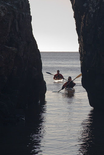
Others like this one, through a stack off Rubha Mor, have eroded away leaving channels just wide enough for a kayak to sip through.

When we rounded Rubha Mor we saw the great sweep of Traigh Mhor backed by the distant Paps of Jura. It is one of the biggest beaches in the Hebrides.

Our two day trip round the south coast and the Oa peninsula of Islay came to an end at the commercial camp site at Kintra. While I pitched the tents and unpacked the gear, Tony cycled the 21km and 360m of height to recover the car at Claggain Bay. If you arrive by sea kayak, check in at the farm before you pitch your tent as there are a limited number of pitches by the sea and you might need to carry your gear about 100m inland.

That night we enjoyed an excellent curry in the unprepossessing Maharani Restaurant in Port Ellen all washed down with lashings of ginger beer (it is not licensed). We both agreed that the west coast of the Mull of Oa is one of the best paddles that we have ever done.

Thursday, September 22, 2011

Blood on the rocks of Loch Ailort

Donald and I had been crossing the mouth of Loch Ailort with the intention of taking a luncheon on one of the beaches on the Ardnish peninsula. However, my knee was now causing so much pain that I was desperate to get out the kayak and stretch my legs, never mind check the dressing on my recently lacerated toe. I spotted this lovely strand of sand on the delightful little Eilean a' Chaolais and called Donald over. We had found another corner of paradise. 

The rock pools were filled with crystal clear water and we had the beach to ourselves apart from...

...this starfish. This beach is covered at high water so we were fortunate to pass when we did.

We were surrounded by the silence and beauty of this huge landscape.

Once we had eaten our lunch Donald returned to his boat...

 ...to fix his flooded engine while...

...I sat on the lichen covered rocks and changed the blood soaked bandages on my right foot. These lichen colonies are probably several hundred years old. They were probably here when Bonny Prince Charlie landed nearby and raised his standard at the start of the Jacobite Rebellion in 1745. After initial success he was defeated at Culloden near Inverness. This was the last pitched battle of two land armies on British soil and resulted in much bloodshed and loss of life. The Highlands were never the same again.

Some (quite a few actually) drops of my bright red blood spilled onto the rocks and added their own colour to that of the rich orange and gold lichen. I may have left a bit of myself  in paradise but in turn, this paradise was now etched indelibly on my brain. We who live in Scotland are so fortunate to be surrounded by such natural beauty, sometimes we just don't appreciate the extent of our birthright.

Tuesday, October 26, 2010

Auchalick Bay, Loch Fyne


We continued paddling north up Loch Fyne along an unspoiled and remote coastline.


By the time we reached Eilean nan Gabhar at the south end of Auchalick Bay, it was time for first luncheon.


What a place to stop. Above high water the rocks were covered with multicoloured lichens and sea pink.


Down at high water level, the rocks were bare but displayed wonderful and ancient patterns.


The north side of Auchalick Bay is bounded by the distinctive slopes of Gob a'Bharra. I loved the way the yellow gorse flowers matched the golden lichens on the rocks in the foreground.

Friday, February 19, 2010

The Bogle Hole, Colvend.


Once through the narrow cleft in the rocks we entered...


...the most delightful hidden cove...


backed by a lovely sandy beach. I have previously mentioned this hidden cove in my Solway podcast with Simon Willis.


Photo T Page.
My knee injury did not allow me to hop around the rocks to take photos from above...


Photo T Page.
...but Tony took my camera and leaped round the rocks like a mountain goat and took these two cracking photos. If you ever paddle the Solway coast, make sure you don't paddle past the Bogle Hole!

Thursday, February 18, 2010

A mysterious cleft at Gutcher's Isle


We left Balcarry Point and the expanse of Auchencairn Bay far behind as the flood tide...


...carried us eastward past the seaward cliffs of Hestan Island. The lighthouse is a recently built tardis design.


We then made swift progress across the mouth of Rough Firth and past Castlehill Point, where many oyster catchers were waiting for the tide to turn.


At high water, we entered a bay called Gutcher's Isle.


At the back of the bay there was a narrow cleft in the rocks, less than a paddle breadth wide. Where would it lead?

Thursday, December 24, 2009

The Silurian simian sentinel of Breddoch Bay


After Crammag Head, the next headland was Laggantalluch Head where we passed the sea stack of Scutching Stock...


...the Cave of the Saddle...


...Ape Rock, which stands like a simian sentinel above Breddock Bay...


...and the incredibly folded and shattered strata of Muddioch Rock.


From the rocks of South Lennans, we could see the distant Mull of Logan. David was getting very tired and was very pleasantly surprised that our destination was in Logan Bay on this side of the Mull.


The delicate Lennans Waterfall poured straight over more stratified rocks, which had been folded to almost ninety degrees from their original horizontal alignment. At the foot of the waterfall there is yet another cave.


Finally, we found there had been a recent landslide at Green Saddle. There was a lovely little flat area of grass, ideal for camping, below where tons and tons of broken rock now lie. There might be a lesson there...

Tuesday, July 21, 2009

Full Moon at Rumblekirn!


It was a full moon when we arrived at Fleet bay on the Solway Firth. That meant a spring tide and that gives access to all sorts of interesting places at high water!


My destination was "rumblekirn", an amazing rock formation, which I recently found. Here the vertically aligned strata of sedimentary greywacke (Hawick rocks) tell of enormous forces that compressed and distorted the Earth's crust in these parts. The name "rumblekirn" means "rumble churn" in Scots. I would certainly not relish being churned round in here at the height of a storm. Waves smash through the back of rumblekirn creating an enormous blowhole.

08/06/2009

Thursday, May 14, 2009

Ardnamurchan to Mull


About 1km to the south of Ardnamurchan we came to the black basalt rocks of the headland of Corrachadh Mor. This is actually the most westerly point of Britain, not Ardnamurchan. However it is possible to drive a car to Ardnamurchan so this lesser point receives the vox pop laudit of being the most westerly point.


Working round the coast of the peninsula we came to the little isle of Eilean nan Seachd Seisrichean at the mouth of the Sound of Mull. The MV Lord of the Isles can be seen entering the Sound on her voyage from Barra to Oban.


We now struck out across the Sound of Mull aiming to land on Mull some 8km distant.


We enjoyed a great crossing with a fair tide, a following wind and helpful swell.


We landed just to the SW of Quinish Point on Mull.


Ardnamurchan lighthouse seemed a very great distance away.

10/05/2009

Thursday, February 26, 2009

Sea kayaking the caves of Caolas Pabaigh (Kyles of Pabbay).


After lunch on the Cuma we launched in the shelter of Caolas Pabaigh a narrow body of water which separates Lewis from the island of Pabaigh Mor.


Both sides of the Caolas are riddled with caves such as this one on the Lewis side.


This monster is on the Pabaigh Mor side has amazing multicoloured rocks.


The booming at the back of the cave was deafening. Just as Tony and I were exiting, a rogue swell came in and I was surfed into the back of the cave again. I found this quite exciting as I tried to do a one handed stern rudder while holding my Canon 5D in the other hand.

05/06/2008

Tuesday, February 10, 2009

Loch Reasort, a long time in the making.


Our first day back on Harris dawned with a freshening SW wind but wonderful clear skies and sunshine. It was good to be back on the water as we left MV Cuma at her mooring. We would rendezvous with the Cuma at the north end of Scarp later in the day.


Cuma had anchored half way in towards the head of Loch Reasort (Resort in English).


We now made our way down the loch towards the Atlantic.


A glacier cut a U shaped valley though the ancient rocks of Lewisian gneiss.


Ahead lay the distant island of Scarp.


As we paddled below the rocky slopes of Taran Mor, 303m, we were looking at rocks that are about 2,500 million years old. Even in this now desolate place, lazy beds betrayed past settlements that are now long forgotten.


Our route from Loch Reasort to Scarp.

04/06/2008