Showing posts with label West Loch Tarbert. Show all posts

Monday, May 02, 2016

A stinking end to a stunning trip on the north west coast of Jura.

 From Shian Bay to Ruantallain on the west coast of Jura the coastline consists of an...

 ...unbroken wall of raised beaches and dry cliffs caves and arches. At sea level there are sharp reefs in an almost unbroken band for six kilometres.

 Rounding one headland we caught sight of Islay and the northern entrance of the Sound of Islay. The north going spring tide was running until early evening so we planned to wait for the south going tide somewhere on the Jura coastline to the SW of the entrance to West Loch Tarbert.

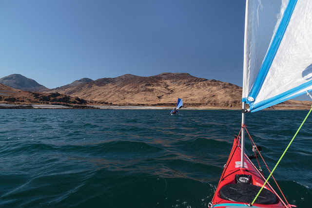
 This was truly superlative sea kayaking. We paddle sailed almost effortlessly under blue skies...

 ...and sparkling blue seas.

 As we travelled south the Paps of Jura heaved above the horizon. The rain that falls on these...

 ...mounds drains into the burns that are used to make our favoured tipple, Jura malt whisky.

 Headland after...

 ...headland sped by. We did try to land...

 ...at Brein Phort (stinking port) but since the map was drawn, what was shown as sandy beach is now just a boulder beach.

 A little further on we rounded the headland of Ruantallain, which marks the northern boundary of entrance to West Loch Tarbert, a deep sea loch which nearly bisects Jura. Under the cairn on the skyline is the cave of Corpach Rubh' an t-Sailean (place of the corpse at the point of the inlet). This was one of the caves where corpses were stored until safe passage could be made for burial on the holy island of Oronsay. No doubt by the time the corpses could be transported they would be stinking to high heaven. Perhaps that is why the local port was called stinking port, or perhaps it was because the port gathered seaweed washed up after winter storms, who knows?

As we crossed the wide mouth of West Loch Tarbert, the British sail training brig STS Stavros S Niarchos drifted up the Sound of Islay being carried by the tide. She spent the night anchored off Colonsay and we would get a better view of her the next day as she made her way back down the Sound of Islay on her way to her current home port of Greenock.

Tony, Phil and I have crossed wakes with the Stavros S Niarchos several times over recent years such as on this occasion on 24/5/2012 off Ailsa Craig in the Clyde. She is named after a Greek shipping tycoon and philanthropist.

 As the wind sped us down the coast of Jura, we could see a great plume of smoke...

...rising from two muir burns on Colonsay. Impressive though this plume was it would have been dwarfed by the plume when our ancestors visited Colonsay 9,000 years ago. In one autumn they cut down all the hazel trees on the island then roasted all the nuts in a huge fire pit, then left. Scorched earth or what?

When we crossed to the south side of west Loch Tarbert we had covered 9km without a break. We badly needed a stop to stretch our legs so we landed at an unnamed beach beside Rubha Lang-aoinidh (the falsely steep point). Well judging by both Ian's and Mike's  expressions they were rather disappointed at their first arrival on Jura's west coast. Indeed I propose to name this beach. From this day forth, let it be known as not as disappointment beach but as Brein Phort Deas (south stinking beach!). Holey Moley this beach was stinking. In fact it was fair minging. I couldn't see rotting corpses of any ancient Juraburghers so I suppose it was just a collection of rotting seaweed. Whatever, we did not stay and I could see that Ian and Mike both thought the highlight of their day had already passed. However, I knew better, I had been this way before (several times before in fact)!.....


Saturday, May 30, 2015

A big egg or a small frying pan?

Tony and I stopped for second luncheon at a little bay on Rubha a' Chrois-aoinidh at the mouth of West Loch Tarbert on Jura. What to eat?

 A big bird.

 An empty nest.

 Is this a big egg or a small frying pan?

As we ate we enjoyed a view over the mouth of the loch to another magnificent raised beach on the north side. After a scrumptious luncheon, the tide had turned and come back in to the boats. It was now time to leave West Loch Tarbert.

Friday, May 29, 2015

The beaches under the Enchanted Mountain of Jura.

From the raised beach on the south shore of West Loch Tarbert on Jura Tony and I set off on our exploration of the outer loch.

A fair wind and the last of the ebb tide helped to propel us...

...past an amazing series of bays backed by...

...raised beaches which were in turn backed by long dry sea cliffs and caves. The Paps of Jura now heaved above the coastal landscape and would be with us for most of the rest of our expedition.

As we approached Glenbatrick  bay the water quickly shoaled to a sandy bottom and turned from ultramarine to...

...dazzling turquoise. What looked like a road on the hillside was actually another raised beach.

We approached Glenbatrick house at the head of the bay. It is locally pronounced Glenabatrick after the original name Glenabedrig.

The house was built in Victorian times for the Astor family and it is the current Lord Astor's holiday home. David Cameron's wife Samantha is Lord Astor's step daughter and the Camerons have enjoyed several holidays here. Tony and I met Lord Astor in 2007 in a remote bay on the west coast of Jura. He seemed a thoroughly decent person. Behind the house the shapely mass of Beinn Shiantaidh (757m) heaved towards the blue vault of the sky. There are several translations of her Gaelic name but I much prefer "The Enchanted Mountain."

We left the turquoise waters of Glenbatrick Bay and paddled over the...

...the deeper ultramarine waters off Rubha a' Chrois-aoinidh (headland of the steep cross) at the entrance of West Loch Tarbert. Then we spotted a little sandy cove, time for second luncheon!

Wednesday, May 27, 2015

Are the raised beaches of West Loch Tarbert, Jura Slartibartfast's crowning achievement?

From Cairidh Mhor in Jura's West Loch Tarbert , Tony and I paddled west through the outer tidal rapids, the Cumain Mhor. A F4 easterly wind had got up (as forecast*) and together with the ebb tide accelerating through the narrows we went through at a fair lick. At the point the above photo was taken, I  had to suddenly divert to port as I was heading directly for a rock at 12km/hr. Just as the sail gybed over, the GoPro camera got knocked off by the rock but fortunately I always tie it on.

 We landed shortly afterwards at...

 ...what must be Slartibartfast's crowning achievement...

...it is one of Jura's most amazing raised beaches. Each year, for over 10,000 years, more and more of it is exposed as the land has slowly risen after the Ice Age ice sheet melted.

 Clean, sea worn pebbles and cobbles stretch upwards as far as the eye can see and at the summit...

This photo September 2009.
...the tide last went out 10,000 years ago. It has taken that long for these few patches of vegetation to establish.

It is at the summit of the beach that the largest cobbles are found. These have ancient colonies of lichens growing on them.

This photo September 2009.
The situation and scale of this beach makes it a unique feature of the British coastline.

The huge raised beach retains a fresh water loch, Lochan Maol an t-Sornaich, but despite the high rainfall in the area no visible river flows out of it.

Instead, innumerable springs like this one issue from its base and as the fresh water mingles with the salt water of West Loch Tarbert it creates swirling patterns of refracted light in the sea.

The ebb tide was still pouring out of the Cumain Mhor as we made our way back to the waiting  boats.

*The forecast wind was why we were here in the shelter of West Loch Tarbert. Our original plan for this time during the trip was to be crossing the west end of the Corryvreckan, to the north of Jura. This would have held less appeal given the force 4 gusting 6 easterly wind, see below...!

This is approaching the west end of the Gulf of Corryvreckan from the north in August 2008. Jura is straight ahead. It is the last hour of the west going flood tide (travelling at 8 knots left to right) and the F4 easterly wind is blowing with the tide. We are in the calm waters of an east going eddy (also 8 knots). It is quite a committing place!

Tuesday, May 26, 2015

A fish ladder in West Loch Tarbert, Jura.

West Loch Tarbert (on the maps it is just Loch Tarbert but everyone calls it WLT!) is full of interest and we set off the explore the middle loch which is bounded by the two tidal narrows. There were many places to stop...

...but we were particularly interested  in a little artificial loch at Cairidh Mhor. There are two dams with the newer one being higher.

The loch was created after the 1881 6" Ordnance Survey map was surveyed in 1878. It does not appear on OS maps until the 1953 1" map.

The fish ladder rises about 3 metres from the sea in...

...four steps. I expect it was built for sea trout. Fishing and deer stalking  provide a significant source of employment to the Jura population.

Tony was like a nimble mountain goat and hopped over the gaps to investigate...

...the majority of the outflow through the sluice rather than down the fish ladder.

Of course he was only pretending to adjust the sluice, it was seized solid!

As my knees were killing me after the previous evening's portage I was certainly not leaping about like a mountain goat so I stayed on the shore and admired these alpine plants growing in cracks in the wall.

There is a boathouse and slipway on the east shore.

Then it was back to the kayaks to continue our exploration of West Loch Tarbert, Jura.