Showing posts with label Trip index. Show all posts

Monday, February 27, 2012

Sea kayaking Ayrshire's Atlantic Coast

A 23km day paddle from Lendalfoot to Finnarts Bay.

Exploring the geos of Bennane Head.


Bennane Head tidal streams:
The tides round Bennane Head are rather interesting. As the flood rushes up the Firth of Clyde, through the North Channel, you might expect it to flow north all the way up the Ayrshire coast. However, it hits Bennane head and splits, so south of the Head the flood is south going!

On the ebb the two streams reverse and travelling at 2.5 knots, they collide off the Head.  This disturbed water can get even rougher against a SW wind.

For kayakers, unless you hit the Head at slack water, you will need to paddle against the tide on one side of the Head or the other.

South of Bennane Head to Finnarts point
SSW going +0425 HW Greenock 
NNE going -0140 HW Greenock 

North of Bennane Head to Lendalfoot
NNE going +0425 HW Greenock
SSW going -0140 HW Greenock

A long shuttle to Loch Ryan...

A solitary perch on Whilk Isle.

The Cannibal's Cave and Skippy the Bush Kangaroo!

Bums on seats round Bennane Head.


An unadventurous lot, down on Ayrshire's Atlantic Coast.


Nightfall and landfall in Loch Ryan.


Friday, January 20, 2012

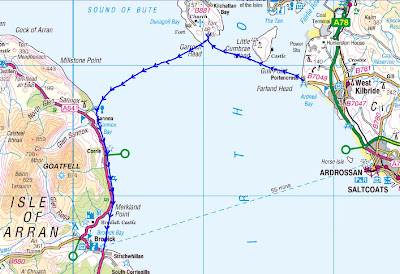
Sea kayaking across the Sound of Bute from Portencross to Brodick.

 A 30km day paddle from Portencross on the Ayrshire coast to Brodick in Arran with return by the ferry.

Paddling from Garroch Head on Bute across the Sound of Bute to Sannox on Arran.

Tides: On the ebb tide there is a tide race off the south end of Garroch Head. This can be rough if there is any south in the wind. The south going ebb starts about -0035 HW Greenock and the north going flood starts about -0035 LW Greenock but these times are very variable being influenced by how much rain and snow melt is entering the estuary. Sometimes there may be almost continuous ebb, especially east of Garroch head. Spring rates are 1 knot but are influenced by rain as above.

On the day, it was springs with LW Greenock at 0814 and HW at 1451. We left Portencross at 0920 arrived Port Leithne, Garroch Head at 1048, left Garroch Head at 1130 arrived Sannox Bay at 1330, left Sannox Bay at 1405 arrived Brodick at 1550. On the two hour crossing of the Sound of Bute (10.6km) we were carried downstream by about 2km.

The ferry arrives at Brodick at 1610 and departs at 1640.

We met before dawn.

The Pavlovian sound of splashing paddles.

First luncheon and a first paddle in the Cetus MV.

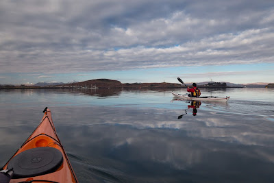
The finest scenic sea kayak crossing in Scotland?

Thank the Lord, for the Ortlieb Aqua Zoom bag!

Sunday, November 06, 2011

Sea kayaking in the Sound of Islay

A 15km half day paddle from Port Askaig, in the Sound of Islay, August 2010.

This is a great place to paddle if you arrive back at Port Askaig in the morning and the ferry back to Kennacraig in Kintyre is not due till late afternoon. We took advantage of a south going tide that was due to turn north in plenty of time to return.

Islay is always worth a visit, more great Islay information at Armin's Islay Blog and Ron's Islay Weblog.

Tides in the Sound of Islay:
The south going ebb  starts at -0140 Oban +05:15 HW Dover
The north going flood starts at +04:40 HW Oban -00:50 HW Dover.
The spring rate is 5 knots off Feolin.

Sitting it out on the Sound of Islay.

Haute Cuisine reviewed at An Cladach.

Fellow travellers in the Sound of Islay.

The power of water in the Sound of Islay.

Close encounter with the RNLI lifeboat at Islay.

Friday, October 28, 2011

Sea kayaking round the Mull of Oa from Claggain Bay to Kintra.

A two day, 43km, paddle from Claggain Bay to Kintra, round the Mull of Oa on Islay, the most southerly point in all of the Hebrides.

Tidal streams 200m off the Oa peninsula at spring tides run at 4-5knots:
NW going flood begins HW Dover (11:31 on the day) overfalls off Rubha nan Leacan, Sgeirean Buidhe, Mull of Oa.
SE going ebb begins -0610 HW Dover overfalls off Mull of Oa, Sgeirean Buidhe, Rubha nan Leacan.

However, we found that close inshore, the NW stream begins about -0100 HW Dover.

The south east coast of the Mull of Oa.

The Mull of Oa.

Islay retrospective #2.

The Ardmore Islands and appropriate consumption.

The intoxicated Giant of Ardbeg.


Taking a break at Lower Killeayan on the Oa peninsula.

There's a kind of hush, all over the Oa tonight.

Oa, what a place to see g-oa-ts and sea eagles!

Oa my! It's a tight squeeze getting out of Bun an Easan!

S-oa-ldier's Rock.

End of the day at Traigh Mhor, Islay.


Friday, October 07, 2011

Sea kayaking the Rinns of Islay.

A 37km, day trip round the west and north coasts of the Rinns of Islay. Launch at Portnahaven NR167521 small shop, hotel/pub, limited car parking nearby, toilets/water at top of hill. Recover kayaks at Crois Mor NR297703 in Loch Gruinart or a few hundred metres to the NE at low tide.

Tides: 
Portnahaven: Constant -0110 Oban (+0550 Dover) Tidal streams off Portnahaven run at 8 knots springs. Heavy overfalls occur off Oronsay and Frenchman's Rocks. In the north going stream a counter eddy forms in Lossit Bay, which can cause confused water where it rejoins the main stream at Frenchman's Rocks. Four hours into the north going flood, we met a SW going eddy along the coast from Cape Fear to Ton Mor.

N going flood begins +0530 HW Oban (HW Dover)
S going ebb begins -0040 HW Oban (-0610 Dover)

It is our experience that inshore streams round Islay turn about 45 minutes before the above published times in the pilots.

Don't be deceived by the calm of Portnahaven harbour, as you leave the harbour...

...all hell can be let loose. An unforgiving coast of cliff and surf beach stretches for an unremitting and challenging 26 km...

...until you turn the corner and find a respite

An Islay retrospective.

Dry mouths in the deceptive calm of Portnahaven.

Commitment off the Rinns of Islay.

Flotsam, jetsam and kayaks off the Rinns of Islay.

The ground was moving and it was nothing to do with the Laphroig!

Singing seals of Loch Gruinart at the end of a long day.

Friday, September 30, 2011

Sea kayaking round Little Cumbrae.


A 22km half day trip from the public slipway at Largs Marina round Little Cumbrae, September 2011.

Rounding Farland Head, Great Cumbrae after a windy crossing of the Tan from Little Cumbrae.


Luncheon with the Little Cumbrae terriers.

Glorious sun, wind and waves at Gull Point.

Wednesday, March 16, 2011

Sea kayaking round Burrow Head.

A 32km day paddle from Port William round Burrow Head to Garlieston, Solway Firth,  January 2011.

Approaching Burrow Head near slack water.

Tides
Well off Burrow Head: 
The east going flood starts -0600 HW Liverpool (-0545 HW Dover). 
The west going ebb starts at HW Liverpool (+0015 HW Dover) 
The spring rate is about 3 knots. 

Close in to Burrow Head:
Strong counter eddies become established in the last 2 hours of the flood and the ebb, so close in, the tidal flows turn two hours earlier than the above times: 
The east going flood starts +0430/-0800 HW Liverpool (+0415/-0745 HW Dover). 
The west going ebb starts at -0200 HW Liverpool (-0145 HW Dover) 


Close in the spring rate is about 4-5 knots and there is turbulence at the eddy line. This means that "slack water" close under the rocks occurs when the main race is still stonking off shore. If there is any wind against tide, the main race will look quite scary and the eddy line will create very confused water. As you are approaching the head, to take advantage of the inshore slack, you will see great lumps of water from the main race heaving on the horizon and you can have a bit of a dry mouth before you round the corner and actually see what it is like.


Saturday, March 05, 2011

Sea kayaking round Kerrera

From Oban sea front round Kerrera, a 23km day paddle on the Firth of Lorn, February 2011.

Crossing Oban Bay to Kerrera. 

Although we started in the town, most usually the best launches would be from Corran Esplanade or from Ganavan Sands. You can also launch over rocks north of the Kerrera ferry, opposite yacht moorings but not at the ferry itself.

Tidal flows.
Sound of Kerrera the flood enters the south end and exits the north end by Oban.
In mid channel:
NE going flood begins +0430 HW Oban (-0100 HW Dover) 1 to 2.5 knots springs.
SW going ebb begins -0155 HW Oban (+0500 HW Dover)  1 to 2.5 knots springs.

In the channel between Bach Island and Kerrera.
Times as above flow 2.5 knots springs. Wind against tide here can cause a nasty steep sea.

Kerrera is usually seen as a beginner trip but even in the calm conditions of this trip we were unable to land on the south coast due to swell. I have never been able to land at Gylen Castle.

Better days in the Sound of Kerrera

Max, the parrot vampire of Kerrera!

Turning a corner on Kerrera

Wot a Loti toing and froing in Oban harbour.

Swanning about in Oban.


A previous trip.


Sunday, February 13, 2011

Sea kayaking round Luing.

 Circumnavigation of Luing: a 32km day trip from Ellenabeich, Seil, January 2011.


18.2 km/hr in the Cuan Sound, between Luing and Seil.

The tide times in the Cuan Sound and the Grey Dogs (also the Corryvreckan) are influenced by low pressure Atlantic systems and can be difficult to predict within an hour's accuracy. However, in a high pressure system they are much more predictable, though times vary between springs and neaps.

The north and west going flood begins +0430 HW Oban (-0100 HW Dover)  at 7 to 8 knots at springs and +0515 HW Oban (-0015 HW Dover) at neaps.

The south and east going ebb begins -0145 HW Oban (+0515 HW Dover) up to 8 knots at springs and -0100 HW Oban (+0600 HW Dover) at neaps.

The time changes by 6.5 minutes each day between springs and neaps. The constant between HW Dover and HW Oban does vary, so most accurate times are calculated by using HW Oban times (though not if you have calculated HW Oban indirectly from HW Dover!!).

On the day, HW Oban was at 0749 and 2011 and it was 1 day after springs so the time had drifted 6.5 minutes from the spring time. So the north and west going flood started about 0749 + 0436 = 1225 and the south and east going ebb started at 0749 - 0139 = 0610. We were on the water by 0955.


The Grey Dogs were salivating, while awaiting our arrival.


Ferry gliding in the Grey Dogs.


A sting in the tail of the Sound of Shuna.


Toberonochy, what's the story?


The stirring sound of moving water in the Cuan Sound.


Darkness stole across the Isles of the Sea.


Saturday, February 05, 2011

Sea kayaking round Morvern

A three day, 114km paddle round the Morvern peninsula via Loch Linnhe, the Sound of Mull and Loch Sunart.

Sunset in Loch Drumbuie, an offshoot of Loch Sunart.

Tides:

Lynn of Morvern/Loch Linnhe
NE flood -0545 HW Oban ((+0110 HW Dover)
SW ebb +0025 Oban (-0505 HW Dover)

There are some peculiarities in the tides here.

A narrow stream of the flood tide entering the Lynn of Morvern hits the Morvern coast and then runs NE to Camas Chronaig where it continues to a point about 1.5km NW of Sgeir nam Tom. This stream runs at about 2.5 knots but elsewhere in the Lynn, the flood runs about one knot..

In the Lynn of Morvern, for the first 3-4 hours of a spring ebb, a SE going stream runs at about 4 knots (with a line of overfalls) from about 220m E off Rubha a'Mothair on the Morvern coast NM759411 to about 1100m NW of the SW tip of Bernera NM778392. Elsewhere in the Lynn the ebb runs about one knot.

Sound of Mull.
The flood tide goes NW and the ebb tide goes SE through the Sound.
At the NW end the flood runs for 7.5 hours and the ebb for 5 hours.
At the SW end the flood runs for 5.25 hours and the ebb runs for  7.25 hours.
The streams turn later and are stronger at the SE end.
Streams by the shores of the Sound turn 30mins earlier than in mid channel.

Throughout the Sound, by the shore,  the SE going ebb starts at approximately -0045 HW Oban (+0615 HW Dover)

The  NW going flood starts by the shore as follows working from NW to SE down the Sound:
Off Rubha nan Gall                 +0400 HW Oban (-0130 HW Dover)
Off Rubh' an t-Sean Chaisteil  +0500 HW Oban (-0030 HW Dover)
Opposite Eilean Glasa            +0600 HW Oban (+0030 HW Dover)
Off Rubha an Ridire               -0600 HW Oban (+0055 HW Dover)

At the SE of the Sound spring rates run up to 2 knots, elsewhere rates are about 1 knot with a bit more round headlands.

Loch AlineIn the entrance:
The in going flood -0525 HW Oban (+0135 HW Dover) 2.5 knots at springs.
The outgoing ebb +0040 HW Oban (-0450 HW Dover) 2.5 knots at springs

Loch Sunart
At the mouth of Loch Sunart the tide rotates through 360 degrees clockwise over 12.5 hours at generally less than one knot.
Within the loch the ingoing flood starts at -0500 HW Oban (+0200 HW Dover).
The outgoing ebb starts at +0130 HW Oban (-0400 HW Dover)
Spring rate is one knot except north of Carna and the entrances to Loch Teacuis 2.5 knots. At Laudale narrows the ingoing spring rate is 3 knots and the outgoing rate is 3.5 knots.

Day one.
Seakayakers, gypsies and bothy dwellers on Morvern.
A missed luncheon after a detour to Kingairloch?
The Boathouse, Kingairloch, Morvern
Between a rock and a hard place at Glensanda.
A bed of bluebells in the Sound of Mull.

Day two.
Trouble in the Isles
Taking the Sound of Mull to the Next World.
Mines a bacon butty in Lochaline!
A series of juxtapositions in the Sound of Mull.
Tobermory, what's the story?
Sardines and showers in Tobermory.
A barren point and fateful decision.
A banquet in Loch Drumbuie!

Day three.
Misty Morven morning.
Three jewels of Loch Sunart: Oronsay, Loch Teacuis and a buried diamond!
A post prandial doze under the ancient oak woods of Ardnamurchan.
Umbrellas in a sunny Loch Sunart.
All the essential sea kayaking elements round Morvern.


Tuesday, January 04, 2011

River Clyde, Glasgow Green to Port Glasgow

Glasgow Green to Erskine.

Erskine to Port Glasgow.

A 33km day paddle on the tidal reaches of the river River Clyde from Glasgow Green to Port Glasgow.

The Arc frames the Glasgow Tower.

HMS Dragon undergoing final fitting out at BAE Systems yard at Scotstoun.

Tides
HW Port Glasgow: +0010 HW Greenock
HW Glasgow: +0020 HW Greenock
Streams turn about local HW and LW.

We launched at 2 hours before HW Glasgow, 5 days before springs. We took 7 hours 40 minutes to complete the trip as we spent a lot of time on the first section to Renfrew. The ebb current became noticeable at 1 hour after HW Glasgow about 8km down stream at Scotstoun. It was moving at 5km/hour and persisted at this rate until 2 hours after HW, by which time we were 17km downstream at Erskine. Beyond Erskine the ebb remained about 3km/hr until we reached Port Glasgow, 30 minutes before local LW.

Note that large ships will manoeuvre on the section up to the KGV dock, timing their arrival or departure for HW Glasgow. There is plenty to keep you occupied further up river before then, so that you pass KGV dock well after HW.

Until recently, Clyde Estuary Control would only let a yacht proceed further up than Bowling with advanced written permission. Canoes and kayaks were only allowed to make the trip as part of an organised "Annual Clydeport Paddle" trip with safety cover provided by the Glasgow Humane Society.

Although this trip was carried out with the permission of Clydeport on the day and the knowledge of the SCA, it should be seen as a trial run. Details have yet to be finalised but it is hoped that trips by competent individuals will shortly be allowed. It is likely that the protocol will be similar to that which we followed on the day, which is outlined below. The SCA will post final details on their website once they are informed by Clydeport.

Before setting off, you should contact Clyde Estuary Control on VHF channel 12, tel: 01475726221, who will inform you of any shipping movements or whether seaplanes are expected to land/take off and warn of areas to avoid, which side of the river to follow etc..

You can download the Clydeport Marine Leisure guide from their website.

You should also contact Clyde coastguard on channel 16, tel: 01475729988 and contact them again once you are off the water. You need to carry a VHF and listen for warnings on channels 12 and 16. You also need to leave your VHF call sign with the coastguard.

Launching/landing sites:
The access gates at Glasgow Green below the tidal weir are locked with a combination padlock. The current combination can be obtained from the Scottish Canoe Association or Sue Hilder, Glasgow City Council Outdoor Access Officer. Tel: 0141 287 8585.

From Glasgow Green, there are no places to land until you get to the slipways at Renfrew and Yoker, which are in use again by the current landing craft style ferries. The ferry crew did not object to a small group of three kayaks landing there for a break, because we kept well to the edge of the slip. I would not choose to stop with a large party, launch or take out there due to the ferry operations.

The next suitable launch and landing sites are at the Erskine and Old Kilpatrick slipways of the old Erskine ferry.

Downstream the traditional kayak launching site at Bowling (Canoe Boys) is now very difficult since the canal basin was redeveloped, unless you have a trolley and are prepared to drag the kayak through the woods on a dog walkers' track beyond the cycle shop in the old railway arch. However, it is an excellent place to stop for a break.

Downstream at Dumbarton Rock park near the Bowling club where you can launch at mid to high tide. At low tide you can launch into the Leven on the NW side of Dumbarton rock. The mud flats east of Dumbarton Rock are part of the Inner Clyde SSSI and are a special protected area (SPA). They are supposed to be important winter feeding areas for waders such as red shank and oyster catchers but anytime I have been there at low tide, I have seen none, though we saw plenty higher up river towards Bowling from our kayaks.

Still on the north bank park and launch here at Ardmore Point at high tide or trolley along the path at low tide.

On the south bank Kelburn Park near Port Glasgow is good at mid to high tide. Newark Castle (Lamont's) slipway is good at all states of tide. Still in Port Glasgow, Coronation park slipway is good at mid to high tide, not sure about low tide.

I would not leave a car overnight at any of these locations.

Sea kayaking from a dear green place.

Sea kayaking the River Clyde: Glasgow Green to the Merchant City.

All Greatness Stands Firm in The Storm.

Famous for not being able to walk in a straight line.

The Clyde, a river of change.

Forward paddling, through the years, on the Clyde.

A tale of two Clyde Titans; one is still standing.

Duncan takes a final curtsy on the Clyde.

Life and death on the Clyde.

Bowling down the Clyde in the Comet's wake.

Clyde built: tough ships, tough people.

Photo Album map.