Showing posts with label Scarba. Show all posts

Wednesday, July 28, 2010

Relaxing, with the roaring of the Dogs in our ears.


The tides carried us north at 8km/hr out of the Sound of Jura into the Sound of Luing, which separates Scarba on the west from Luing on the east.


The east coast of Scarba is sheltered from the prevailing wind and has a thick growth of deciduous woodland. Both red and fallow deer can be seen here. Kilmory Lodge lies 88m above sea level while the summit of Cruach Scarba 449m towers high above.


We had now been paddling for two hours and ten minutes. Even with tidal assistance, we were ready for lunch by the time we reached Poll na h'Ealaidh, Scarba's sole claim to anything resembling a harbour. The view to the north, through the Sound of Luing and across the Firth of Lorn ended in the distant mountains of Mull and Morvern.


We walked out to the end of the pier, hardly able to believe that we had just paddled all the way from the distant hills of Knapdale behind us.


We had a leisurely lunch while the tide built up to full speed in the nearby Grey Dogs, which lie between Scarba and the steep rocky knolls of Lunga to the north. Relaxing afterwards, with the roaring of the Dogs in our ears, Tony helped put Phil at ease by telling him about the huge standing waves we would encounter in the races ahead. "You'll be fine Phil, it's easier when the waves are bigger than 8 feet, they're more spaced out!"

Monday, July 26, 2010

Trying to hold a straight course in the Dorus Mor.


We crossed the Sound of Jura towards Eileen na Cille. We had predicted that the flood tide would start at 10:25. Initially the last of the ebb carried us SW...


...but at 10:20, without any perceptible period of slack, the transits showed the flood had started to carry us NE. Because I hadn't been out recently, I quickly fell behind the others but soon hit on an excellent delaying tactic. "Hold it there for a moment! I see an excellent photo, if I was just a little nearer!"


We broke out of the tide and entered a sheltered lagoon between Eilean na Cille and Garbh Reisa and for the first time saw our ultimate destination, the distant Gulf of Corryvreckan. The feeling of space, after being confined to the house for 5 months following my knee operation, was quite overwhelming. So much so, that for a moment, I thought I was going to loose my balance and capsize on this perfectly flat sea. Only for a moment though! I would certainly need my balance later in this paddle!


Despite the apparent calm in the lagoon, the flood tide was already building and the water level on the east side was higher than on the west side.


We now paddled up the west side of Garbh Reisa. At its north end, an eddy carried us north into the Dorus Mor tide race. Once we crossed the eddy line into the main flow, we were ejected out of the Dorus Mor at a most satisfactory 13km/hr. It was only 25 minutes after the turn of the tide. The tidal rule of thirds does not really apply to the races in this constricted part of the Sound of Jura.


Once we had cleared the race, Phil paused to look back through the Dorus Mor.


We were now heading for the little island of Coiresa. Despite being well clear of the narrows, the sea was still full of boils and eddies. It was difficult to hold a straight course. Jennifer and Tony are both trying to get to the same place!

Sunday, July 25, 2010

Slack water in the Sound of Jura.


We left Glasgow at 07:00 and it was 09:10 when we finally drove down to the slipway in the little village of Crinan in Argyll. Across the Sound of Jura, the horizon was blocked by Jura to the south and Scarba to the north. Hidden between them lies the great Gulf of Corryvreckan through which surge some of the most powerful tides on Earth.


All was calm as we left Crinan on the last of the ebb tide.


There was no wind to ripple the water and the reflections of yacht's masts lay straight on the calm surface of Crinan's natural harbour.


We past Ardnoe Point and entered the Sound of Jura, backed by that island's eponymous Paps.


It was now slack water and the transit between the distant light of Ruadh Sgeir and Jura behind did not change. However in the upper Sound of Jura, slack never lasts very long!

Tuesday, November 24, 2009

The mystery of the goats of Reisa an t-Sruith


We now were on a course back to the Dorus Mor and Crinan but first we had to clear the north end of tiny Reisa an t-Sruith. Its name means something like the race of the torrent.


Initially we were carried north but very quickly the ebb started carrying us south and we just scraped past its north end under the eye of watchful goats. How they got out here I can't imagine. Either goats are very powerful swimmers with a built in ability to understand tides and ferry angles or they were brought by man. I can understand sheep being left on small islands until they grow for market, but goats?


Overhead, these pink footed geese seemed to know where they were going.
They will recently have arrived from their summer grounds in Spitsbergen Iceland or Greenland. If they get the weather right it does not take them long. This year a mute swan with a GPS tracker took 14 hours to cover 800km from Iceland to Scotland.


Rounding the top of Reisa an t-Sruith, we took a quick look back at the Gulf of Corryvreckan before we were swept onwards to the Dorus Mor.

Monday, November 23, 2009

Calculating slack water in the Corryvreckan

I am currently writing a sea kayaking guidebook book for Pesda Press "Argyll and the South West, Ardnamuchan to the Solway Firth by Sea Kayak. (ISBN 978-1-906095). This is one of the most complex areas of the UK coastline and I am determined that it will be a piece of work which is thoroughly researched, both in terms of previously published information and also of first hand experience.

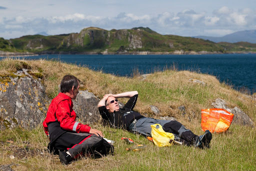
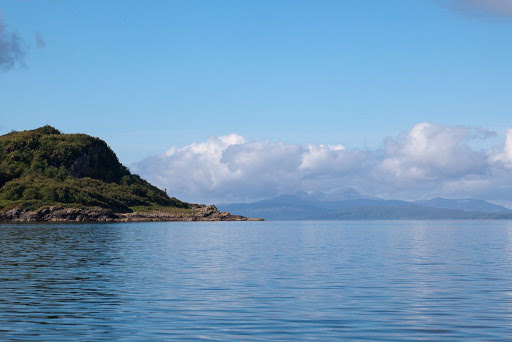
I think I am pushing the good will of Franco, the publisher, but I do not want to rush a guide based on my experience of a piece of coastline on one trip, one way, in one set of weather conditions. The Corryvreckan is an example of a serious bit of coast, a key point in the planning of any voyage in these parts. If you click the Corryvreckan tag link on the right, you will discover that we have passed through this Gulf E/W both ways, along both coasts, crossed it N/S both ways, at a variety of states of tide and in a variety of wind and swell conditions. We have camped on both its north and south shores and climbed into the hills of Scarba and Jura to photograph the various eddies and over falls.

For those of you who are interested in such a sea kayaking guide, I appreciate your patience, thank you.

According to published data, in the Corryvreckan, the west going flood starts at -0100 Dover springs and -0015 at neaps. The east going ebb starts at +0515 Dover springs and +0600 at neaps, a time difference of about 6.5 minutes per day between springs and neaps.

On the 16th October 2009 it was 2 days after springs, HW Dover occurred at 1025 and 2256, so the slack between the east going ebb and the west going flood should occur at -0047 HW Dover ie 0938 and the slack between the west going flood and east going ebb should occur at +0528 HW Dover ie 1553.

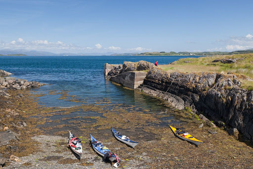
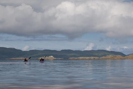
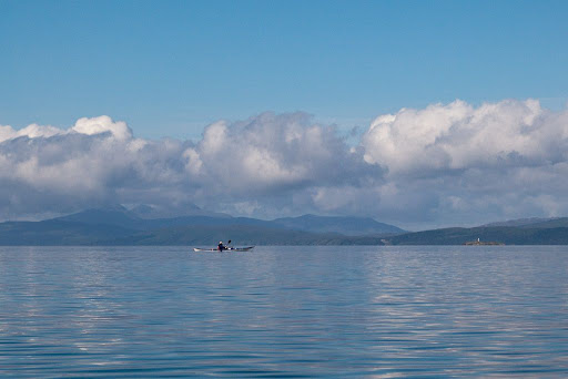
We entered the west end of the Corryvreckan at 1446 and landed at Camas nam Bairneach at 1500. We enjoyed a view of the flood in action and a short luncheon but were keen to be on the water, in mid channel, to observe the exact moment of slack water. We launched again at 1525.


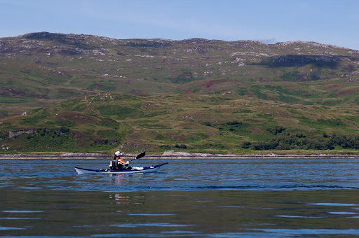
Phil powering into the last of the flood at 1530. The current was still flowing west at 2.5kn.


At 1539 several yachts entered the Corryvreckan. At 1544, in mid channel, the current was still flowing west at 2kn (see map below).


Then at 1549, with the soaring ridges of Ben Cruachan in the distance,...


...the water turned oily calm and slack water had arrived. It lasted a whole 5 minutes until the ebb started with a bang and boils and eddy lines disturbed the surface again. In the distance, you can just see the small lighthouse on Reisa an t-Sruith in front of Tony's bow.


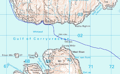
So the published start of the flood was calculated at 1553 and we observed slack water between 1549 and 1554. Pretty good Eh?

Well, err, actually no. There was no wind and we were in a high pressure system with preceding light winds and little swell. There are very many factors that can alter the change of tide in these parts and you need to go prepared to observe what you find on the day (and of course to have checked your calculations).

Thank you for your patience while I get the book right... :o)

Saturday, November 21, 2009

Showdown with a goat in the Corryvreckan!


We entered the Corryvreckan in somewhat calmer circumstances than our last visit. Even in windless conditions the flood was bubbling and boiling like a witch's cauldron. The sight and sound of such a huge volume of water rushing by at 18km/hour was quite moving, in fact Phil later described it as a buttock clenching experience.


We took the counter eddy (that runs east along the south shore of Scarba) right into the heart of the Corryvreckan until we came to the headland before Camus nam Bairneach. The eddy ended at a small headland and swung out into the main flow where it joined the rotating mass of water which forms the whirlpool. I said “Phil you need to get round this headland so paddle quite hard and don’t look back.”


The best chart for discovering the various eddies is the 1856 Admiralty chart.


The headland is in the bottom middle of this photo taken from high on the slopes of Scarba. Here the eddy (calmer water in lower right in the photo) swings out into the main flood (which is flowing to the right) where it joins in a great swirl that creates the whirlpools of the Corryvreckan. To get round this headland into the shelter of the bay you do need to paddle quite hard for 150 metres. If you can't PLF and get round the headland, you are in for a very special treat. The eddy will carry you right into the whirlpool and the Great Race beyond, so you can get a really close look at this natural wonder. Make the most of this experience but just don't expect to be able to share it with others afterwards.


We got round the headland and landed in a little bay to wait for the flood to ease off. We took this territorial goat by surprise, it clearly was not used to having its privacy invaded during the flood! The smelly brute squared up to us and stood his ground but his harem of females all ran off up the hill. Ultimately he found them more attractive than a confrontation with us and he made a measured retreat.


We had to drag the boats well up the beach...


...as seething surges of tidal water threatened to whisk them away into the jaws of the ‘vreckan.


Tony took some photos from the headland, which we had recently fought our way round.


This is the Corryvrekan on a windless day. In a westerly gale the standing waves reach 5m in height and can be heard in Crinan 13km away. Fortunately for Phil, this is just about as calm as it gets.


While Tony was taking photos, Phil was content to sit and gaze in wonder. I think he was still a bit shaken after our confrontation with a goat!

P.S. Please remember that the Corryvreckan is a very large and serious tide race. It is in a remote location and, if you do get into trouble, it will carry you straight out into the open Atlantic for 5 miles before the Great Race subsides. Mike Murray knows a great deal of the Corryvreckan and how unpredictable it can be. A visit to his website should leave you under no illusions about the seriousness of this paddle. Another website well worth a visit is David Philip's Hebridean Wild. His gallery contains many photos of the Corryvreckan such as this one, which is enough to send a chill through any kayaker's heart.

John F asks: "Okay, so how bad would it be if one were swept through the whirlpool? If you had to hang on to your boat, do you think you could keep your head above water? Don't know if I want to find out, first hand."

Well John, a recent TV documentary about the Corryvreckan called Lethal Seas featured an interesting experiment. A weighted dummy wearing a life jacket was dumped into the sea just before the Corryvreckan whirlpool. It disappeared within moments. It was recovered several miles out to sea half an hour later. A dive meter showed that it had been down to at least 200m and the dummy's life jacket had gravel in its pockets and straps.

Friday, November 20, 2009

Menace hung in the windless air, even for the most daring and venturesome.


Common sense would suggest that we should have relaxed on the beach on Scarba's NW coast until near slack water in the Corryvreckan.


We were not having any of that, we wanted to see the whirlpool in action!


As we paddled down the west coast of Scarba, with Colonsay on the horizon, it gradually dawned on Phil that the only way back, was through the Corryvreckan!


As we worked our way down the coast...


...Jura began to appear...


...above the raised beaches of Scarba's wild SW corner.


The rule of thirds does not apply to the Corryvreckan. The spring tidal flow remains at a full 18km/hr almost until slack water, which at springs only last a few minutes. This was the situation as we rounded the SW tip of Scarba with an hour and 10 minutes before slack water.

We were going to use a counter eddy along the south Scarba shore, which the Clyde Cruising Club describes thus: "There is a ribbon of comparatively smooth water within 10m of the whole of the S Scarba shore, but this passage is not recommended, even for the most daring and venturesome."


As we approached the entrance to the Corryvreckan, a fine mist hung in the windless air, which betrayed the menace of the seething currents below.

Thursday, November 19, 2009

Free fall on Scarba


Tony and Phil carried the boats well above the tide line as we know that there is the possibility of tidal surges here. A tourist RIB roared round the bay en route from the Corryvreckan to the Grey Dogs. These trips bring much needed visitors and money to the local economy.


This was a marvellous spot to relax and have lunch.


We had a terrific view over the Firth of Lorn to Ben More on Mull.


The cliffs that surrounded our little beach formed a natural amphitheatre with walls over 100m high.


This waterfall cascades over the full height of the cliffs. In wet weather it forms an impressive spout.

We enjoyed our view of the mountains and the waterfall for free!