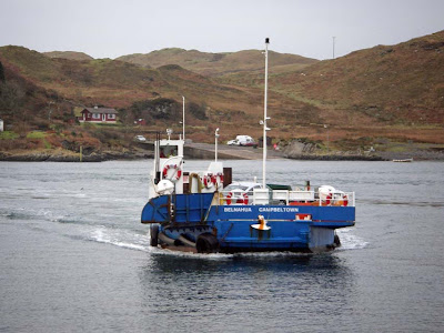
Showing posts with label Garvellachs. Show all posts

Tuesday, May 20, 2008

A camp by the Dogs.


After unloading the kayaks...


We set up camp and climbed the hill behind the beach where we glimpsed tomorrows destination, the Garvellachs on the horizon.


Looking the other way we caught sight of the Grey Dogs tidal race on full flood. That standing wave is about eight feet high.


The tide fair rips through the gap at over 22km/hr.

Monday, May 12, 2008

A wee trip to the Garvellachs


The Garvellachs (Rough Islands or Isles of the Sea) are a chain of magnificent small islands which lie at the mouth of the Firth of Lorn, where they are exposed to westerly Atlantic swells.

This is travelling SW down Eileach an Naoimh, Isle of the Saints.


On Sunday we had a fabulous day circumnavigating these islands. This is at the SW corner of Garbh Eileach, travelling NE.


Some of the swells made an impression on us.

I must apologise for the grainy quality of these photos. I was using my Canon 5D but every so often I would need to put it away in a hurry. In my fumbling, I reset the sensor speed to 1600 ASA and did not notice....


Of course we did not go directly to the Garvellachs! Oh no, we went via the tide races of the Sound of Luing, the Gulf of Corryvreckan and the Grey Dogs. What a great part of the world to be a sea kayaker!

11/05/2008

Sunday, July 01, 2007

Crossing to Scarba


Leaving the fertile grassy slopes of the

Garvellachs, we headed south east for Scarba. It is a barren and rocky isle with few places to land. We stopped here for a second luncheon whilst we waited for a favourable tide in the Corryvreckan. In this view the Garvellachs can be seen in the middle distance with Mull beyond.


The GPS track of our route.


From the Garvellachs the horizon to the south east is blocked by Scarba on the left and Jura on the right. From this distance the Gulf of Corryvreckan, which lies between, them looks like a sheltered sea loch.


There is a raised beach on top of a line of cliffs which surround most of Scarba's coast. This means that even if you can find a landing spot, access to the interior is barred by the cliffs. No wonder the 5th century monks chose the Garvellachs!

Saturday, June 30, 2007

Eithne's grave.


This simple stone, incised with a Celtic cross, can be found on a peaceful knoll, high above the monastery on Eileach an Naoimh in the Garvellachs.


We have wandered and spent time reflecting here several times before traversing the tides of the Grey Dogs or the Corryvreckan. I have always enjoyed the contrasting emotions experienced on such sea kayaking trips.

The grave is thought to be the last resting place of St Columba's mother, Eithne.

Sunday, June 03, 2007

Walking among the stones of history in the monastery of Hinba.


The monastery on Eileach na Naoimh was founded by St Brendan of Clonfert in AD 542. At that time the Garvellachs were known as Hinba or the Isles of the Sea.


St Brendan was born in County Kerry in Ireland in AD 484. In addition to his Christian faith he was a great seafarer and was also known as Brendan the Navigator. He left on a seven year voyage to discover the fabled Celtic island of Tir nan Og (or Land of Perpetual Youth). Some say he discovered North America but what is certain is that he came here to Hinba and founded a monastery. Some buildings are beehive cells similar to those found at Skellig Michael in Ireland. Even St Columba, came to Hinba for some peace and meditation and to escape from the bustle of his monastery on Iona. St Brendan's influence is also remembered in other local place names such as the Kilbrannan Sound.


The island has been uninhabited for a thousand years since the Vikings sacked the monastery. Today, even in the spring sunshine, wandering among the ancient stones of Hinba, you are surrounded by echos and ghosts of the past.


Ancient grave stones protrude above the encroaching mosses and grass. Their only markings are the patterns of lichens, which grow in abundance in the clean air. The identities of the occupants of the graves below are unknown but they were our ancestors and like us they were attracted to this necklace of islands to escape the everyday world. Unfortunately for them, 500 years of peaceful meditation were ended by a change in the outside world; the arrival of the Vikings.

To this day St Brendan is the patron saint of seafarers and (dare I say it?) sea kayakers.

Friday, June 01, 2007

Clochain (beehive) cells on Eileach an Naoimh


The beehive cells of Eileach an Naoimh


Continuing round the north end of Eileach an Naoimh in the Garvellachs we travelled down the east coast past the natural rock arch of An Clarsach. Not long afterwards we spotted the best preserved beehive cells in Scotland. They were built and used by generations of Celtic Christian monks who followed St Brendan of Clonfert who had arrived on the Garvellachs in AD 524.


The monastery was sacked by the Vikings in the early 10th century and today the only inhabitants of these ancient walls were these tiny ferns.

Tuesday, May 22, 2007

Through the Grey Dogs to the Garvellachs.


11th May 2006. Heading out from the Grey Dogs into the Firth of Lorn with Scarba on the port bow.


Crossing to Eileach an Naoimh (Isle of the Saints), the most southerly of the Garvellachs. We followed the great circle route used by trans Atlantic jets. We decided to stop before we got to Newfoundland.


The west side of Eileach an Naoimh under the new Garvellachs light. The light was established in 1904 and this one bas built in 2003. It has a white flash every 6 seconds. My friend Clark Fenton, who is a fully card carrying geologist, informs me that the rocks are composed of a Precambrian age [approx 1 billion years old] tillite (a metamorphosed glacial boulder clay) that contains large blocks of marble. The marble is a dolomite (a magnesium rather than calcium rich limestone) that has been recrystallised by heat and pressure.


Shadow and light under Precambrian cliffs of tillite.

Sunday, May 20, 2007

Cuan ferry: passport to the Grey Dogs and Corryvreckan!


MV Belnahua

The tidal Cuan Sound (between the isles of Seil and Luing in the Firth of Lorn) runs at up to 15km/hr. The little ferry, the MV Belnahua, makes the short crossing several times a day. It is very instructive watching her ferry glide. The captain only ever crosses the main flow at right angles to save fuel. He then uses the slacker water and eddies at the sides to make his way back to the jetty.


MV Grey Dog

I have not been able to get out paddling recently so this photo is from last May. When we arrived we found that the Belnahua was off on its holidays, leaving the tiny MV Grey Dog in its place.


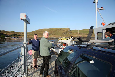
It was just big enough for David's car and my trailer and it lurched alarmingly as we drove on. There is no turntable so you need to reverse off. David did not fancy this so I had a go. I did pretty well until the last moment when I clipped the front bumper on the ramp sides.


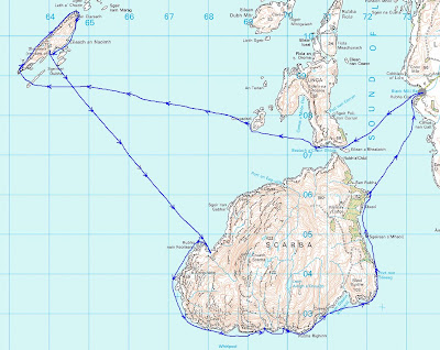
It did not spoil our day, it allowed us to have a fantastic day trip from Glasgow out through the Grey Dogs tidal channel, round the Garvellachs, back to Scarba then home via the notorious Corryvreckan. We had tidal assistance all the way!

There is one point to note about the Cuan ferry. Although Calmac list the timetable, it is actually operated by Argyll and Bute council. Calmac state "We cannot be held responsible for any errors or omissions".

More about that another day....

Friday, February 16, 2007

An Clarsach


An Clarsach, "the harp", is a lovely natural arch at the NE corner of Eileach an Naoimh in the Garvellach Isles at the mouth of the Firth of Lorn. It is composed of tillite which is a metamorphosed glacial boulder clay.