Tuesday, April 22, 2008

Home to roost.


I like staying on the water till well after sunset. This April evening was so calm that the only movement was that of a colony of common gulls returning to their noisy roosts on Murray's Isles. I paddled back to the distant Galloway shore and the gulls' calls grew ever more distant as I left their world and returned to mine.

14/04/2007

Wednesday, April 16, 2008

The mystery of the first of the seven stanes.


On the watershed between Glen Trool and the Dee valley we crested a hill and paused to take in the view of Loch Dee. Rory, the Border terrier, spotted something in the heather.


It was an amazing giant's axe head, carved out of granite and highly polished. Rory looked perfectly at home, in this, his natural environment.


Its surface was inscribed by runic symbols. It was peaceful to sit there, surrounded by the Galloway hills, glens and lochs, wondering what it meant.

It is one of seven stanes. Each is located in one of Southern Scotland's 7 Stanes mountain bike areas.

13/04/2008

Tuesday, April 15, 2008

MacLellan's Castle, Kirkcudbright


If you kayak with the tide up Kirkcudbright Bay and land at the slipway in Kirkcudbright, you can walk into the old part of town past the Harbour Cottage.


You will soon come to MacLennan's castle. This was completed in 1582 as a grand town house, although it was modelled in the style of a traditional Scottish L shaped tower house. It was owned by the provost of Kirkcudbright, Sir Thomas MacLennan. It never suffered siege damage and Sir Thomas's heirs ran out of money so it was never extended. As a result it is pretty much as it was originally built. It is open to the public.

The memorial carries the names of the local dead from WW1 and WW2.

22/03/2008

Monday, April 14, 2008

The hill tracks of Galloway and the harvest of the sea


From a distance it looks like the hill tracks of Galloway have a dusting of snow.


But as you walk or ride on the tracks, the crunch of this white covering is like no snow.


It is composed of tons of scallop shells which are a by product of the Kirkcudbright scallop fishing industry. There is no more space to dump them at the back of local farmers' fields, so they are now brought up here and dumped on the hill tracks. As the shells break down, the calcium carbonate might do something to reduce the effects of acid rain which has damaged the Galloway hill lochs.

Seeing the sheer number of scallop shells scattered on these hills, you realize just how big the scallop industry is. I know the Irish Sea is a big place but I do hope this proves to be a sustainable fishery.

13/04/2008


The following is an extract from SEPA View, issue 17 Autumn 2003 the magazine of the Scottish Environmental Protection Agency.

Evaluate use of waste scallop shells as road dressing to improve acidity in watercourses

Manager: Stuart Coy

Of 500km of fishless waters in Scotland, Galloway has 400km. Much of this relates to the extensive forest coverage in the area, which exacerbates acid rain. The trees filter out the acid and concentrate it, so when it rains the acidified water runs into the nearby watercourses. In many countries, lime has been successfully used to counteract acidity either by direct addition to water or application over the catchment land. However, this is an expensive and perhaps unsustainable procedure. As scallop shells are 95 per cent limestone in composition and the country’s largest processor of waste scallop shells, West Coast Sea Products, is situated in Galloway, an action plan was established to determine whether the shells could be used as a viable means of reducing levels of acidity in local watercourses. As waste, the shells must be disposed of in a manner that conforms with the exemptions laid out in the Waste Management Licensing Regulations 1994 which permits them to be used in road construction. Two methods are currently being employed. In the first, clean, crushed shells are incorporated into the sub-base aggregates, effectively burying them. The second, more appropriate use, is as a road surface dressing. In theory, the passage of vehicles will speed up the release of calcium.

SEPA Galloway team leader, Stuart Coy said: “This experimental use of shells is still very new to Galloway and the logistics of getting them from the factory to the forest in an acceptable condition are continuing to develop. If it can be made to work then it seems there will be benefits all round. “Should there be a reduction in the quarried aggregate required for road construction, the use of the shells in this way means that they will not be going to licensed landfill which would have cost around £100,000 for disposal. Ultimately, much-needed calcium will be released into acidified surface waters.”

Sunday, April 13, 2008

The Merrick and the Galloway hills.


A mountain bike is a great way to get round the Galloway Hills in SW Scotland. The Merrick is the highest hill on the Scottish mainland south of Ben Lomond. Its summit is still iced in the last of the winter snows.


Starting from the car park at the Bruce's stone above Loch Trool, we covered 28km and 900 metres of ascent and decent.

13/04/2008

Saturday, April 12, 2008

Wreck of the Schooner Monreith


There are no harbours accessible at all states of the tide on the whole stretch of the Scottish Solway coast from Gretna in the East to the Mull of Galloway in the west. Following the many indentations of the coast, this is a distance of over 270km. Danger to ships is confounded by the large tidal range of nearly 10m at springs and the extensive sand and mud banks which are exposed at low tide. The whole coast is exposed to southerly winds and swells and if ships were caught out by a storm at low tide they had to try and find shelter at the entrances to the firths. Only when the tide was high could they make their way up the river channels to the shelter of the wharves in such towns as Kirkcudbright.


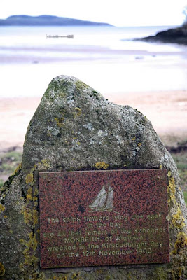
On the 12th November 1900, the two masted sailing schooner Monreith, from the Galloway port of Wigton, was carrying a load of granite kerb stones from Newcastle in County Down, Northern Ireland to Silloth in England. A storm blew up and she attempted to take shelter in the mouth of Kirkudbright Bay (behind Little Ross Island, the island with the lighthouse on the horizon.) The bay was not yet deep enough and grounded and was driven onto the sand banks of Goat Well Bay where her timbers were pounded by the surf until she sank. Her crew were able to launch a boat in her lee and made their way safely ashore just as the Kirkcudbright lifeboat arrived. Monreith's sturdy timbers can still be seen reflecting in the wet sands at low tide.

22/03/2008


If you launch or land at Dhoon Bay near high water, you will miss this part of the Bay's history.

Goat Well Bay, Nun Mill Bay and Dhoon Bay are pretty much synonymous. Although not used on the map, Dhoon Bay is the current local name.

29/09/2007