Showing posts sorted by date for query columba. Sort by relevance Show all posts

Saturday, April 30, 2016

Dead beat and washed up at Corpach Bay, Jura.

Well in need of a break, we were delighted to find a breach in the NW cliffs of Jura at Corpach Bay.

The name tells a little of the history of this lonely spot. "Corpach" means place of the corpse and it was here that the people of Kintyre, Jura and Islay would leave the corpses of the deceased if it was too stormy to cross to the burial isles of Oronsay and Iona. Caves near Ruantallain to the SW were mostly used for the passage to Oronsay to the south of Colonsay. The caves at Corpach Bay were used for the passage to Iona. One of the largest is called Corpach Challuim-chille which loosely translated means place of the the corpse of the church of St Columba.

 Anyway after our hard paddle through the Corryvreckan the previous day and our early start, we were feeling dead beat and so where better too rest than Corpach Bay?

 After swapping paddles over, (we are currently comparative testing the excellent new VE Voyager paddle) we...

 ...unpacked our second breakfast things...

 ...and made our way up the beach.

Corpach Bay was easy to land on when we visited but it is often exposed to heavy surf and I would not like to meet these boulders in a loaded boat being driven in by surf.

 We could hardly belive how quickly the swell had dropped as less than 48 hours previously, the ferries were not running.

 I  thought this boulder buried in the sand looked a bit like a misshapen skull.

 Anyway, the sky was blue, the sun was shining and what a spot...

 ...we had found for second breakfast. Ian and briefly considered a quick swim in the sea as a wash up but a chill wind from the north had picked up. We were not the only ones to be washed up on Corpach Bay...

...these lobster pots and cobbles from the beach had been washed up by winter storms and were now left lying well inland from the beach.

Tuesday, November 18, 2014

For richer and poorer in the Hunterston Channel.

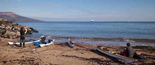
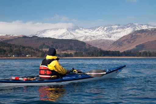
I have not paddled on the Clyde since my mother died in July and as Sunday 16th November was forecast to be such a beautiful day I decided it was time to get back out. A trip to Little Cumbrae, Bute and The Eileans from Largs seemed in order so after a few texts I met up with regular paddling buddy Phil but also Andrew, Colin McM, Colin R and Maurice, all from my old home town of Ayr.

 We used the ebb to head down the the Hunterston channel past...

the Hun 5 starboard channel buoy,...

 ...the coal and ore terminal and...

 ...the "robbing the poor to pay the rich" offshore wind turbine test bed. This so called green scheme is funded by a tax on every citizen's power bill and subsidises multinational companies and land owners to build these expensive, inefficient and resource greedy monsters. There is nothing renewable about this industry which damages the environment and the sea bed during both construction, running not to mention disposal after their short working lives have expired.

As we drove into Largs, the Kelburn and West Kilbride windmills were all turning. Do you notice how much wind there was? They were being turned by electricity generated by the Hunterston B nuclear power station, which is just to the right of this photo. It is a common public relations stunt when it's calm. Then when it is windy they don't turn because they break or go on fire like this one at West Kilbride. What is needed is another nuclear power station station but we are unlikely to get one in Scotland while the Nationalists hold power in Edinburgh, as they are in bed with the Greens. Anyway, back to the test bed, these monster turbines are prototypes for thousands which are planned for off the west coast of the Hebrides. I really doubt the politicians and the industrialists have a clue about how much it will cost to build and maintain them in the harsh conditions out there...

Land based wind factories also have problems. They are destroying the wilderness across Scotland and developers and land owners are getting away with it because most politicians and "green" city dwellers (who all leave their lights and chargers on) don't give a monkey's cuss about the countryside.

Wind farms represent the biggest redistribution of wealth from the poor to the rich in this country since the Norman invasion of 1066. (Even that proto-nationalist, Robert the Bruce, was a Norman!)

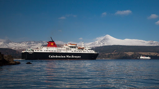
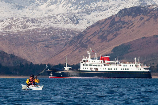
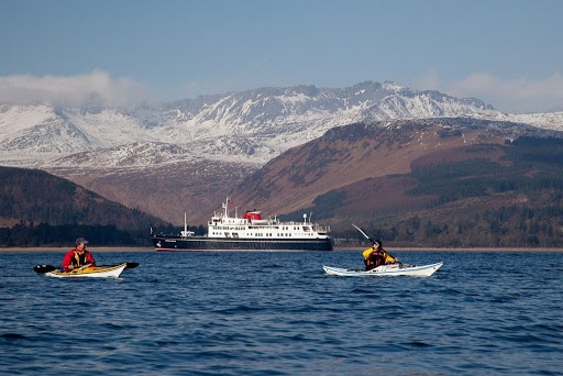
Talking of the rich, this lovely little ship, the MV Hebridean Princess, was anchored in Millport Bay. She was built in 1964 in Aberdeen and as MV Columba served as a ferry on the Inner and Outer Hebrides for what would become Calmac. When she was retired  in 1988 she was the last Calmac ferry to load cars with a hoist. She was bought by Hebridean Island Cruises who operate her as a luxury cruise  ship for 50 passengers. A double cabin in peak season will cost you well over £1000 per night. Since the Royal Yacht Britannia was retired, the Queen has chartered the Hebridean Princess several times for Royal cruise parties. I would love to go on a week's cruise on her but don't have the spare cash. I had better go and switch the heating off and start saving.

Friday, January 24, 2014

Possibly the base for a standing cross.


We made our way down from the summit ridge of Eileach an Naoimh to the site of what is reputed to be the site of  the grave of Eithne who was the mother of St Columba.

St Columba had followed St Brendan from Ireland, bringing Christianity to the west coast of Scotland. He founded a monastery and church on Iona. However, it thought that he and the monks came to Eileach an Naoimh on religious retreats. They knew the island as Hinba.

Saturday, July 06, 2013

Mistaken location of St Fionnlugh's chapel, Cara?

Having arrived on Cara a day early we thought we might have a long lie but...

...our new neighbours had other ideas and low flying Canada geese can express their ideas very vocally. They started about 5am...

 The early summer flora was more laid back...

 ...and we set off to explore Cara on a path through the bluebells which...

 ...led to Cara House.

 First we inspected the old building to the NE of the house and found that the mortar that bound its ancient stones together...

 ...had been made from sand from the shore. Sea shells were clearly visible. This building looks very much like the mediaevel chapel of Cara. The chapel was dedicated to St Fionnlugh who was a contemporary of St Columba. The OS map, Hamish Haswell-Smith and Canmore all give the location of the chapel as a pile of stones to the SW of Cara house. However, the photograph in Canmore is quite clearly of this building by the house. Also Old Statistical Account (1793) description (quoted by Haswell-Smith) describes lancet-shaped windows with splayed inshots in the east ends of the side walls, which this building has....

Looking from the entrance in the south wall to the splayed inshot window at the east end of the north wall.

The chapel was also latterly used as a kitchen for Cara house and the pile of stones on the OS map is rather far to be convenient for the house. Also, although the pin on the Canmore map points to the OS "chapel", the 10 digit OS grid given by Canmore points to this building.

The corner of the sheep pen marked on the O map as the chapel.

Haswell-Smith himself says that the the OS "chapel" could easily be mistaken for a sheep pen. I think the stone structure to the SW of Cara House was a sheep pen. It measures some 30 yards by 4.5 yards and according to the OSA the chapel measured some 9yards by 6yards which are the measurements of the building on the NE side of the house. So based on the description of the Old Statistical Account of Scotland, the building close to the NE of the house was the chapel.

Cara House was built in 1733 by the Macdonalds of Largie for their tacksman. It was last used by a resident on Cara in the 1940's when the tennant farmer left.

It is rather grim looking and I am not surprised that the spirit of The Brownie has taken up residence there.

Despite The Brownie's presence Cara House was renovated as a holiday home in the 1990's.

We left Cara House to the hopefully sleeping Brownie and pressed on through the bluebells.

Friday, May 25, 2012

My (very) small part in The Great British Story.

Tonight, the BBC broadcast the first episode of The Great British Story: a People's History. The first programme, Britannia, dealt with the period following the fall of the Roman Empire. Throughout the Dark Ages, civilisation clung on in the western fringes of Britain as the east coast was invaded by the Anglo Saxons. The programme followed the voyage of St Columba from Ireland to Iona off the west coast of Mull. He brought Christianity into the northern land of the Picts (who had never been part of the Roman Britain having been isolated  by first the Antonine, then the Hadrian walls).

St Columba had founded religious settlements on many of the islands he stopped at on his route north. The programme showed the ancient Celtic Christian carved stone crosses that still stand on the islands of Islay and Oronsay. Standing at the foot of these wonderful crosses, which are worn by the gales of 1,200 winters, is a humbling experience.

The above photo is of one of the crosses of Oronsay. It was shown for all of several seconds. I was quite pleased. It was one of mine!

Thursday, May 13, 2010

Egalitarian cruising on the Clyde


After arrival at Brodick, we trollied the kayaks off the ferry and turned hard left at the top of the ramp. This took us to a little beach of reddish Arran sand.


We were on the water quickly, almost as soon as the MV Caledonian Isles took to turn around.


We launched into light winds and flat water which was in total contrast yo the conditions on the far side of the Clyde. We had not only made the right navigational decision, we had enjoyed a nutritious breakfast on board the ferry!


Beyond the MV Caledonian Isles we spotted the MV Hebridean Princess at anchor on the other side of Brodick Bay.


The MV Hebridean Princess is a former CalMac ferry that has been converted into a small luxury cruise liner. Don't expect to get much change from £2,500 per week in the cheap cabins. However, I understand the cuisine is in a different league to the fare we enjoy on the Arran ferry! Note the freshly painted navy blue hull which was previously black. Hebridean Princess has just undergone a major refit and this was her first outing in her smart new livery.

She was built in 1964 and, as MV Columba, she served on many routes out of Oban. Latterly she was a relief vessel for more modern RoRo ferries. When she was sold to Hebridean Island Cruises in 1988, she was the last hoist loading ferry in CalMac's Western Isles fleet. Originally she took 50 cars and 870 passengers. In her current role she carries only 49 passengers.


Cruising on the Clyde can be enjoyed by rich and poor, it's a very egalitarian activity.

We were looking forward to our yummy SPAM sandwiches, here is what those cruising on Hebridean Princess could look forward to:

Fresh Hand Dived Scallops
With a Thai green curry sauce

Isle of Mull Cheddar Cheese and Red Onion Tart

Carrot and Orange Soup

——‡——

Fresh Fillet of Sea Bream, Savoury Pancake
With red pepper dressing and sautéed greens

Guinea Fowl with a Herb Mash and Ribbons of Courgette

——‡——

Chocolate Nemesis with Crème Chantilly
And mint syrup

Strawberry Pavlova with a Duo of Coulis

Selection of Cheeses

——‡——

Coffee and Petits-fours
Will be served in the Tiree Lounge, the Conservatory and the Look Out Lounge


YUM YUM YUM!

Monday, October 05, 2009

The crosses of Oronsay


Walking up to Oronsay House, I asked Mrs Colburn if it was easy to get to the Oronsay Cross.

"You will find two crosses very easily, they are just beside the Priory."

"Oh, I had wondered if we might have passed the old stump of a cross down by the dunes." I replied.

Without a hint of irritation, Mrs Colburn quietly answered "That 'old stump' is the memorial I erected to the memory of my dear husband in the Millennium year."

Oops! "Sorry!"

She continued "I do hope you enjoy your visit, it's such a nice day and there have been so few like it this year."


The Great Cross of Oronsay stands inconspicuously against the farm buildings at the back of the Priory graveyard. It is finely carved on both sides and is thought to have come from Iona.


It has suffered from the weathering of five centuries but this drawing, which was published in Thomas Pennent's, A Tour in Scotland and Voyage to the Hebrides, 1772, shows the west face in detail, when it had been standing for only 272 years. The inscription reads:

+HEC EST CR/UX COLINI F/ILII CRISTI/NI M(EIC)DUFACI
'This is the cross of Colinus (Malcolm), son of Christinus MacDuffie

It was carved for Malcolm MacDuffie, the Lord of Colonsay, some time after 1472 and erected before 1500.


This is the beautiful east face of the Oronsay Cross. Next to the Kildalton Cross, on nearby Islay, it is one of the finest crosses in all of SW Scotland.


Another interesting, but older, cross stands on a little knoll to the east of the Priory. In 1881 just the shaft was standing and the present head of the cross lay on the ground beside it. There is some doubt as to whether this is the original head but it has now been replaced atop the shaft.


It is decorated by a rather portly and smiling figure.


From the grounds of the Priory, you can look out over the sea to Jura, Islay and Ireland. It is said that St Columba, who had been banished from Ireland, landed here but proceeded to Iona because he could still see his homeland from Oronsay.

Saturday, October 03, 2009

A reluctant visitor to the Priory, Oronsay (not London).


When I first mentioned to David that I wanted to visit the Oronsay Priory, he became quite distressed.

"They'll never let us out, we'll need to go into rehab and walk the twelve steps!"

"Relax David, its not the Clinic, it's just a very well preserved religious complex."

So we found ourselves approaching the beautifully maintained grounds of the Oronsay Priory.


The buildings date from the mid 1300's but there may have been a chapel here since St Columba's time. The Priory was founded by the Lords of the Isles and became a centre for religious sculpture until about 1500. Some say St Oran gave his name to Oronsay but I rather doubt this as Oronsay is quite a common name for tidal islands on the west coast. It comes from the Old Norse and means island of the ebb tide which is exactly what Oronsay is. You can walk to it from neighbouring Colonsay at low tide.


It is one of the best preserved medieval religious buildings in Scotland. It was too remote to be destroyed in the Reformation, like many of its more accessible contemporary religious buildings.


Although there are no traces of its roofs, the walls, including those of the cloisters, are still in remarkably good repair.


Fortunately for David, our departure from the Priory was unhindered by a locked door. He took a deep breath, followed by a great sigh of relief.