Tuesday, January 20, 2009

The church and evolution on St Kilda.


The manse was the residence of the visiting minister. It lies remote from the village and some way off the street which connects it to the store by the sea. The islanders' Soay sheep were moved to the island following evacuation and have been left to their own devices since.


They breed and die with no animal husbandry or veterinary intervention. Their corpses lie where they fall. Countless generations of selective breeding by the St Kildans stopped in 1930 and since then the population has been subjected to the forces of natural selection and survival of the fittest. Interestingly the proportion of lighter coloured but smaller sheep has steadily increased in the population. A long term study by the University of Sheffield has demonstrated that this is due to changing frequency of a group of genetic variants that decrease size and lighten coat colour but increase reproductive fitness. This study provides molecular evidence for evolution in action and supports Darwin's theory.


Both the manse and the church, which lies immediately behind it, were built from 1826 to 1829 to plans by Robert Stevenson (of lighthouse fame). The first minister to live in the manse was the Rev Neil MacKenzie. A schoolroom was added to the side of the church in 1900. After the evacuation of the islands in 1930, the buildings fell into disrepair. The manse was restored in the 1950's for use as the sergeants' mess in the military radar base. The church and schoolhouse were restored in 1980.


This photograph is part of a display in the schoolroom. It shows the islanders leaving the church after a service on the Sabbath. By the 1880's the islanders had become gripped by an extreme form of Presbyterianism and religious observance. Their previous joy in music and dance had died out and preparations for the Sabbath interfered with the very work which was essential to their survival. By the beginning of the 20th century the grip of religion had slackened slightly but by then it was too late and the islanders would not be self sufficient again as their population numbers went into terminal decline.

I wonder what the ministers' thoughts on evolution and genetics might have been?

03/06/2008 am

Monday, January 19, 2009

The village head dyke of St Kilda and its Australian connection.


A very characteristic feature of the Village on St Kilda is the head dyke which contours above the current crescent of the village street. It is built right through older structures such as this cleit and it incorporates some very large slabs of rock. It encloses the village houses and cultivated plots from the open grazing land on the hills above.


The mediaeval village was higher up than the current village and was a cluster of simple houses. The current layout of the village was planned by the Rev Neil Mackenzie who was minister to St Kilda from 1829 to 1843. A Devon man, Sir Thomas Dyke Acland, made several visits to St Kilda and in 1834 he left £20 with the minister in order to encourage the people to build better houses. The St Kildans constructed black houses along the crescent of the current street and built the head wall in the years following 1834. Mackenzie had to lead just about every aspect of this work, by direct physical involvement.

Acland's business interests included a schooner, the Lady of St Kilda. This traded with Melbourne in Australia and in 1842 the suburb of St Kilda was established, with an Acland Street. In 1856, 36 St Kildans emigrated to Australia but half of them died en route. Perhaps they had heard of the prospects for a better life there from the well intentioned Acland. The plots of cultivated land within the dyke that had been allocated to these emigrants was thereafter known as common ground.

03/06/2008 am

Sunday, January 18, 2009

The cleitean of St. Kilda.


A grassy "street" leads from the store up to the houses that form the village on Hirta. It passes by the first of many cleitean (cleits) that you will discover on an exploration of the village. Indeed they are one of the most characteristic features of the topography of Hirta as you enter Village Bay by boat. These simple store structures are unique to St Kilda.


This is cleit number 1 on the map included with the really excellent booklet Buildings of St Kilda produced in 1988 by the Royal Commission on the Ancient and Historical Monuments of Scotland. On the side away from the sea and the prevailing SW wind, there is a low doorway. The roof is of turf over stone slabs and the walls are of loose drystone construction which lets the wind blow through for ventilation and drying. Some cleitean near the village had wooden doors to exclude animals while other had simple stone slabs . Most were built on a slope so that the floor would drain downhill.


They were used to store dried birds and fish, preserved eggs, barley, potatoes, cut peats and turfs and ropes. There are some 1,260 cleitean on Hirta and over 170 on the other islands and Stacs in St Kilda. Martin Martin mentioned them in the first written account of St Kilda in 1697. On the side away from the prevailing winds this cleit had a wonderful cap of thrift (or sea pink) flowers.

Many cleitean are of great antiquity but interestingly we know that this one was built relatively late in St Kilda's populated history. It was not yet built in a photograph taken in 1886.

03/06/2008 am

Friday, January 16, 2009

The St Kilda gun emplacement


Just beyond the store at the edge of the village street on Hirta, you will find this 4.7" quick firing naval gun emplacement overlooking Village Bay. It seems so out of place in such a peaceful spot. There must be an interesting story behind such an incongruous finding!

After the devastation reeked on Allied Atlantic shipping in by German U boats in WW1, the Royal Navy installed a wireless signalling station on Hirta. On May 15th 1918 a U boat surfaced in Village Bay. It fired 72 shells into the radio station. The nearby store, manse and church suffered some damage but none of the village houses were it. In fact, the only casualty of the bombardment was a lamb.

In response, the Royal Navy constructed the emplacement with a sunken magazine and a QF gun from a naval gunboat. It was completed by October 1918, a month before the end of the war. It was never fired in anger.

03/06/2008 am

Thursday, January 15, 2009

The feudal store of St Kilda


On making one's way up from the jetty on Hirta, the main island in the St Kilda archipelago, the first building encountered is the store. It is the first modern building on the island and was constructed sometime before 1818. The walls were built using lime mortared stone. The end walls were gabled and constructed with chimneys. The roof was of slate. At that time, the St. Kildans lived in blackhouses whose rounded walls were built from stones and turf and the roofs were made from turf or thatched with barley straw.

The substantial nature of the store was necessary as this was where the island produce of the preceding year was stored. It awaited the annual visit of the factor from the mainland. He collected the islanders' rent in kind, which was to paid to the landlord, the chief of the MacLeods of Dunvegan in Skye. Goods consisted of feathers and oil from seabirds and woven woolen cloth called tweed.

Just behind the store you can see the barrel of a large gun and further on, the wreck of the Spinningdale.

03/06/2008 am

Wednesday, January 14, 2009

Nightfall over Ports Ramsay and Appin.


We rounded the north end of Lismore leaving the distant lights of the Glensanda quarry far behind us on the other side of Loch Linnhe.


We now entered the maze of channels behind the islands which shelter Lismore's Port Ramsay from the sea.


On leaving Lismore the SW horizon turned blood red below an ultramarine firmament, which was punctuated by Venus.


By the time we had crossed the Lynn of Lorn it was almost completely dark and the air temperature had fallen to -5C. This brought our 2008 paddling year to a conclusion. What an incredible end to a fantastic year.

27/12/2008

Tuesday, January 13, 2009

Sunset behind Mull


Leaving Bernera we made good time up the north west coast of Lismore. We were keen to reach Rubha Ban, the north west point of Lismore, before sunset.


However, it was 9.5km to the point and the sun began to sink behind Bernera and the distant mountains of Mull while we were still afloat. We stopped and drifted while we photographed the magnificent sunset.


Alan and I put on a spurt to reach the headland...


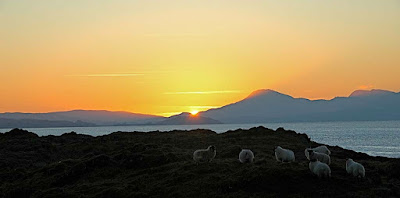
...while Tony stopped off on little Eilean Loch Oscair. Whatever our viewpoint, it was a magnificent sunset behind Glas Bheinn (492m) on Mull.


This is the view that Tony saw. Remarkably there was a small flock of sheep on this tiny island. I do hope that they enjoyed each other's company, it's a long winter to be stuck on a rock!
Photo Tony Page.


We watched in silence till well after the sun had sunk below the horizon. It was nearly dark before Tony joined us at the point and we still had 5km to go back to Port Appin.

27/12/2008