Wednesday, January 14, 2009

Nightfall over Ports Ramsay and Appin.


We rounded the north end of Lismore leaving the distant lights of the Glensanda quarry far behind us on the other side of Loch Linnhe.


We now entered the maze of channels behind the islands which shelter Lismore's Port Ramsay from the sea.


On leaving Lismore the SW horizon turned blood red below an ultramarine firmament, which was punctuated by Venus.


By the time we had crossed the Lynn of Lorn it was almost completely dark and the air temperature had fallen to -5C. This brought our 2008 paddling year to a conclusion. What an incredible end to a fantastic year.

27/12/2008

Tuesday, January 13, 2009

Sunset behind Mull


Leaving Bernera we made good time up the north west coast of Lismore. We were keen to reach Rubha Ban, the north west point of Lismore, before sunset.


However, it was 9.5km to the point and the sun began to sink behind Bernera and the distant mountains of Mull while we were still afloat. We stopped and drifted while we photographed the magnificent sunset.


Alan and I put on a spurt to reach the headland...


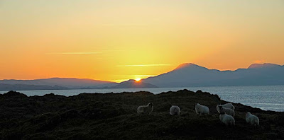
...while Tony stopped off on little Eilean Loch Oscair. Whatever our viewpoint, it was a magnificent sunset behind Glas Bheinn (492m) on Mull.


This is the view that Tony saw. Remarkably there was a small flock of sheep on this tiny island. I do hope that they enjoyed each other's company, it's a long winter to be stuck on a rock!
Photo Tony Page.


We watched in silence till well after the sun had sunk below the horizon. It was nearly dark before Tony joined us at the point and we still had 5km to go back to Port Appin.

27/12/2008

Monday, January 12, 2009

Carry that weight on Lismore.


We landed on a delightful beach on Bernera. We had a second luncheon followed by a slumber in the golden sunlight as we waited for the tide to rise over the bar, which was blocking our way back homeward. Unfortunately the sun was now getting alarmingly low so we had to leave....


.... before Bernera was fully an island again. Tony and David carried the double over the still dry rocks. I, on the other hand, had to carry that weight of being expedition photographer! (With apologies to Paul McCartney)

27/12/2008

Sunday, January 11, 2009

Achadun Castle, Lismore


We were soon powering up Loch Linnhe and leaving the Sound of Mull in our wakes. We decided to cut another kilometer off our trip by cutting inside the tidal island of Bernera. If the tide was not sufficiently high then it would just mean another stop to watch it rise!


The inside passage also allowed a closer look at Achadun Castle on the SW of Lismore. This was built by the MacDougalls at the end of the 13th century. It passed to the Bishops of Argyll but was abandoned by them about the middle of the 15th century. It seems to have been disused since then.

27/12/2008

Saturday, January 10, 2009

Five Canada geese, four sleek kayaks, three lofty mountains, two light houses and a ..... Fiart!


After a calorific luncheon of Christmas cake we reluctantly left Eilean nan Gamhna and we were soon heading south towards the Sound of Mull. A skein of Canada geese flew overhead with whooshing wing beats. Our progress was not so rapid and it was obvious we would be returning in darkness again.


In the distance the MV Isle of Mull ferry entered the Sound of Mull on her way to Craignure between the Lady's Rock lighthouse and the the Eilean Musdile lighthouse. In the distance, the mountains of Mull soared up from the Sound.


As we were running out of time, we decided to cut through the narrow channel to the north of the lighthouse by Rubha Fiart. This would save 1.8km and after our recent trip round the Mull of Galloway, neither Tony nor I felt we had anything to prove.


As we entered the narrow channel at the south of Lismore, the tide had already turned. It was now flooding strongly and carried us westward towards distant Duart Castle on the south shore of the Sound of Mull.


We were now leaving the Lynn of Lorn and were soon expelled into the waters where the Sound of Mull joins the mouth of Loch Linnhe.


Feeling rather bloated after all this exertion, we drifted in the tide for a while...


... before digging our blades into the glassy waters on the way to our next stop on the tidal island of Bernera.

27/12/2008

Friday, January 09, 2009

Explorers and the rock tower of Eilean na Cloich.


This intriguing rock tower is on Eilean na Cloiche, one of a group of delightful islands in the Lynn of Lorne.


We stopped on nearby Eilean nan Gamhna to admire the view of the tower. It is backed by the distant mountains including snow flecked Bidean nam Bain, which is the highest mountain in Argyll and Ben Starav.


This view demanded a prolonged luncheon break.


The seakayakphoto.com staffers are hardened athletes in the peak of fitness. They put themselves through extremes of physical endurance and hardship (often in the depths of winter) in order to bring to you, dear readers, photos and tales of voyages to these distant places. In a word, they are explorers.

27/12/2008

Wednesday, January 07, 2009

Dun roving on Lismore!


Our recent trip to the delightful island of Lismore continued...


....with tidal assistance down a glassy Lynn of Lorn. The low winter sun slowly achieved its zenith as the ebb gathered its full flow.


Lismore is such a fertile isle that it was always seen as a prize in historical times. It has many defensive duns and castles of different ages and eleven are still named on the 1:50,000 OS map. This one is a Pictish broch called Tirefour Castle. It is probably about 2,500 years old. Originally it would have tapered upwards to about 7 times its current height but over the centuries its stones have been robbed for later buildings.


The tide carried us relentlessly onwards and the distant mountains of Mull appeared, rising steeply behind the gentler slopes of Lismore.


My goodness this was hungry work and after passing yet another dun, we spotted a lovely beach ahead on a little island called Eilean nan Gamhna. Time for a break!

27/12/2008