Thursday, January 11, 2007

Valley Nordkapp LV test.


A version of this test first appeared in UK Paddles magazine in April 2006.

There have been a number of changes in the UK sea kayak manufacturing scene recently. P&H are now moving forward as part of the Pyranha stable and Valley are now run by Pete Orton and Jason Buxton who formerly worked at P&H. This test was a chance to see how the new Valley team were doing and involved an exciting new design for the keen paddler; the Nordkapp LV. It was supplied by a dealer new to Valley; Scottish Paddler Supplies.

Testing took place over the Scottish winter, spring and early summer and in a variety of conditions and locations in Scotland.


Scarp in the Outer Hebrides.


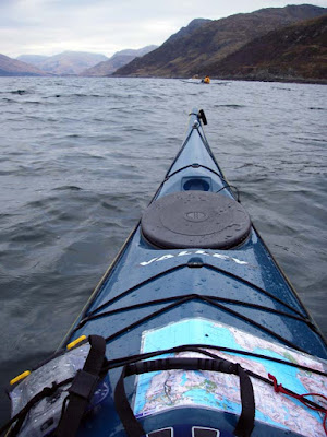
Loch Nevis in the north west.


St Abbs Head and


Coldingham in the south east.


The north coast of Rum. Inner Hebrides.


The Gulf of Corryvreckan.


Various locations in the Firth of Clyde and the Solway in the south.


Finally to the Ecrehous reef between Jersey and France.

The boat was paddled alongside reference boats including 2005 Rockpool Alaw and Alaw Bachs, 2005 Nordkapp Jubilee and 2005 P&H Quest. The various male and female testers weighed between 60 and 90 kg and experiences ranged between intermediate to expert. Conditions ranged from force 1 to Force 6 gusting 8, onshore and offshore with a variety of water conditions.

The Valley Nordkapp LV.


This is the most beautiful sea kayak I have ever seen. It is a series of graceful curves and flowing lines. The only straight line is the “V” on the fore deck. Even the keel is highly rockered. Compared with the Nordkapp Jubilee, this boat is a completely new shape. The only dimension it shares with its namesake is overall width. It has much finer bow and stern sections.

Construction, finish and ergonomics.
In the recent test of the Point 65 boats from Sweden, I commented that their finish was superior to some contemporary UK boats. Then last year Rockpool produced their stunningly well finished boats and now Valley have joined them, putting UK manufactures at the top of the quality tree. The finish on this boat is absolutely superb. Including keel strip and ready for the water it weighs 24kg and even smaller women commented on how easy it was to lift. In comparison, the Alaw was 26.5 kg but it does have a thicker lay up on the hull and has proved itself in close contact rockhopping.

The deck lines, fittings and end toggles are all good well proven Valley items. The seat back is supported by four straps that attach to the seat pan and rear bulkhead. It is comfortable and the straps prevent it folding forward under your bum during wet re-entries (unlike other designs which use shock cord). The seat pan is a new plastic moulding. It is lightweight and has a removable pad which gets wet and can’t be wiped dry. This will mean you will get a wet bottom if you like to paddle in shorts in the summer. The three largest paddlers had to remove the seat pad to physically get their thighs under the cockpit rim. (Neoprene pads are supplied unfitted for thinner paddlers to glue under the cockpit coaming.) All still found the unpadded seat and relatively straight legged position to be very comfortable. If you are too big to fit in, it is possible to remove some of the foam under the seat and fit shims under the cockpit coaming. If this still does not give enough room, I would be tempted to remove the seat and replace it with a foam seat. The long keyhole cockpit with a low foredeck makes it one of the easiest boats to get in or out of.

The skeg operated faultlessly and the exposed section of the cable (which is liable to kink in other designs) was enclosed by a stainless steel sleeve. The wire is still easy to remove for lubrication. The hatches were all Valley’s own design. The front one was oval. They were difficult to get on and off with cold fingers but were completely waterproof despite several wet sessions. The footrests are adjustable Yakima pegs on an alloy track which is attached by bolts through the hull. When new these adjusted easily but after a rolling session in a sandy bay, they jammed. Paddlers with small feet found their position comfortable but those with larger feet found the curve of the hull limited contact with the pedals. In contrast, the adjustable, angled full footplate on the Rockpools was so much more comfortable. For a personal boat I would consider not ordering the footrests, order a custom bulkhead and make a large footpad from ethafoam.

Performance.
They said: "Designed for either the lighter paddler who wants an expedition proven sea kayak or a larger paddler who wants the legendary performance of the full sized Nordkapp but wants more manoeuvrability and doesn't need the full carrying capacity of the full sized version." Two friends have Nordkapp Jubilees and I have enjoyed paddling both when fully loaded, but even with my weight of 85 kg, I find them bouncy when unloaded in a chop with wind. I was really looking forward to the Nordkapp LV

This boat feels so, so alive and responsive! It lacks the initial tippiness of an unladen Nordkapp Jubilee but it is so responsive to the slightest lift of a knee and this (together with the boat’s response to the bow rudder stroke) made manoeuvring round the labyrinth of tight rocky channels of St Abbs an absolute joy. A much more experienced paddler, following in the Aquanaut, could not match the tight lines this boat took. The Rockpool Alaws are designed for manoeuvrability but the Nordkapp LV could match every turn. However, as you edge an Alaw the boat becomes progressively stiffer and more secure feeling, as you edge the Nordkapp LV it just keeps going over smoothly until sploosh. There is no warning when you are just about at the limit of secondary stability. Intermediates learning edging and bow rudder strokes found the Alaws to be much easier.

I was expecting it to be manoeuvrable, given all that keel rocker, but I was not expecting it to be fast. However, it accelerates to top speed with fewer strokes than any other boat I have paddled. And what a burst speed it has! The Nordkapp LV managed 11.6km/hr. In comparison; the Quest managed 10.5 km/hr, the Alaw 10.1km/hr, the Jubilee 9.8km/hr and the Aquanaut 8.6km/hr. This top speed is just the thing if you need to power round a headland against a tide but in truth all the boats seemed to settle down nicely at 6.9km/hr, my usual cruising speed.

This boat handles rough water. It thrives in wind against tide or a combination of overfalls and clapotis under a headland. Like many Valley designs it tends to throw its bow high over approaching steep waves. In strong winds in an unladen Jubilee or Aquanaut this can result in the bow getting blown downwind. In the Nordkapp LV this does not happen. However, it is quite a wet boat and you will need to have a well fitting spray deck. Above force 4 it starts to weathercock and although you can control this with edging, the skeg makes for a much more relaxed paddle on an exposed crossing. The Alaw Bach has no skeg but is a very well balanced boat even in strong winds. However, paddling it side by side with the LV in force 5 to 6 winds demonstrated the extra versatility given by the Nordkapp LVs skeg. You might not need it very often but when you do, it does make life much easier. We had planned a day to the Cuan Sound to see how the Nordkapp LV handled tidal eddy lines. Unfortunately, the boat arrived too late so we took it to the tidal weir at the mouth of the River Doon. The jet coming out the weir was travelling at 26km/hour and the boat handled crossings like a dream.


Crossing the eddyline at the tidal weir on the Doon.

With such a narrow stern, I was not expecting the Nordkapp LV to be able to pick up following seas as easily as a boat like the Alaw. I was wrong, the Nordkapp LV’s acceleration means you can pick up swells actively rather than relying on the hull shape of the stern to give you that final boost to catch a wave. I managed a burst speed 18.6km/hr on a nice piece of Solway surf! This brings me to rolling. The LV rolls very easily. It is also very easy to re-enter and roll the boat; the straps keep the back rest well out of the way. In a rescue situation, it is very easy for the rescuer to completely empty the Nordkapp LV simply by raising the bow and using the bow rocker as a lever to twist the boat upside down. The Alaw has less bow rocker and is more difficult to twist over.


What about the LV’s use as an expedition boat? Well there was not much enthusiasm for camping at this time of year but I tried it loaded with 40kg of weight. Together with my weight of 85kg plus 10kg for clothing and safety gear, this brought the waterline up to the deck seam. Heavy weights can use it as an expedition boat if they accept having less volume for bulky items than a Nordkapp or a Quest. When the Nordkapp LV is loaded it has a much more predictable limit of secondary stability. This means that if you are light and value secondary stability, it might be best to view this as an expedition boat rather than as a day boat.


In the fore hatch I managed to fit in a 3 man tunnel tent, 5mm full length Thermarest, down sleeping bag, Force 10 4 man mountain shelter, oddment dry bag with SLR size camera, radio, car keys, spare batteries etc. and a 1 litre wide mouth nalgene bottle with repair kit. In the cockpit, I had a six litre water bag and I am sure there would be room for my Kelly Kettle in place of a knee tube. In the stern hatch I had a folding stool, walking boots, two dry bags with clothes, toilet bag, folding bowl, folding wind shield, MSR 1.5l/1.0l/frying pan cookset with mini stove inside, large gas cylinder, two cups, bowl, plate, cutlery, kitchen roll and kindling, firelighters and lighter for Kelly Kettle. The day hatch was free for food etc. Despite its LV name, this is still an expedition boat.

Dimensions.
As measured rather than quoted: Length 532cm, breadth 53cm, cockpit 79cm x 40cm, height of cockpit front 33cm, weight standard construction with keel strip 24.0kg.


Hull plan shapes.

Conclusion.
The Valley Nordkapp LV is a superbly made expedition boat for smaller paddlers. It is as manoeuvrable as a day boat (albeit at the cost of some secondary stability) and it is also fast. Valley seem to have achieved the Holy Grail of sea kayak design: the LV has speed, manoeuvrability and sufficient volume! It is a boat that the progressing paddler will delight in for its excitement and responsiveness. It is also a superb day boat for heavier paddlers while still having enough expedition carrying capacity for all but the heaviest of packers. What else should you consider? Early intermediates looking for a day boat should also try the superb Rockpool Alaw Bach which is just as manoeuvrable but is a more predictable learning platform that will flatter ability and speed skill development. Hardcore rockhoppers should also consider the Rockpool for its heavier and stronger construction and in extreme conditions even experts appreciate secondary stability.

What is the overall verdict of the Valley Nordkapp LV? Well apart from carrying capacity, we could not find a single criterion in which the Nordkapp Jubilee retained superiority. The Nordkapp is dead. Long live the Nordkapp LV! It is outstanding, beauty really isn't skin deep! As a result of this test, three Nordkapp LV’s have already been ordered and more are being saved for! I feel I must award this boat 12/10!

Footnote.
Since this review was published, several friends and I have bought Nordkapp LV's. Experience since then has not changed any of the conclusions above. Mine developed a leak from where the skeg cable enters the skeg box. It was fixed without question and returned within 3 days. I have used it successfully for weekend camps but I chose to take my Quest for a 10 day trip to the Outer Hebrides due to its greater carrying capacity . The plastic seat fitted to 5 boats supplied in the spring and early summer of 2006 were fitted much higher than in the tested demo boat. Indeed two purchasers were physically unable to fit into their own boats despite having fitted in the demo. Slimmer purchasers found their boats to be tippier than the demo boat. Valley sent us a batch of alternative plastic seats which allowed lower fitting. This was achieved by removing foam from under the seat and shimming the resulting space under the cockpit and the top of the seat mounts. The Nordkapp LV has only been available with the plastic seat but it was noted that a 2006 Nordkapp with a plastic seat had
its seat 4.5cm higher than a 2005 Nordkapp Jubilee with the original GRP seat. This problem is not restricted to Valley. P&H plastic seats are also fitted higher than their GRP seats but at least P&H still offer the GRP seat as an option.

Second footnote.
Jonny asks:
I am just wondering if anyone has experience of this boat in reasonably big surf. (5-8ft). I live in Cape Town, South Africa. Often I will need to beach with the surf pumping. Getting out is never a problem.
Just hoping that this boat does not nose dive, and wondering how it handles sitting on the wall of a wave?

Jonny the Nordkapp LV's ability in surf outdoes my abilites, so I will just answer by posting a sequence of photos of my friend Cailean MacLeod coming in through the surf in at Coldingham.


Does that answer your question? :o)

Wednesday, January 10, 2007

How is it? It's as bad as it gets.


West coast of Scarp

June 2006 was stormy off the west coast of the Outer Hebrides. We were out there in a 70 foot fishing boat and had to run for "shelter" in Loch Reasort.


Loch Reasort

At times like that I always think of the RNLI. Have a look at John's blog for details of their work. I have been a supporter of the RNLI for many years and I would urge all UK and Irish seakayakers to give their support. Today I received my copy of "The Lifeboat" the RNLI journal.

It tells of a dramatic rescue (a few days later than my photos above) which involved a Dutch 12m racing yacht. She was pitch-poled and flattened by a monster wave in winds exceeding force 9 about 25km to the north west of Barra at the south end of the Outer Hebrides. The skipper was injured, the shroud plates were damaged, her standing rigging loosened, the mast mounted electronics were damaged and the keel bolts loosened. He put out a PAN PAN call on the VHF requesting urgent assistance.

Stornoway coastguard picked up the call and requested the launch of the Barra lifeboat. She is the Edna Windsor a Severn class and Coxswain Donald MacLeod took command. He was really worried that the yacht would attempt to reach shelter through the treacherous Sound of Barra to the north but could not make contact with her. He decided he would need to take a shortcut up the east of Barra and through the Sound to head the yacht off. There are three routes through this sound and the best would depend on many factors. Donald called his father and asked if he could go over and advise which route he should take.

"Caimer a tha i?" (How is it?)

"Tha i cho dona 's chi thu I" (It's as bad as it gets.)

The lifeboat had to reduce speed from 25 to 5 knots as it slammed into 10 to 11m swells. Eventually they cleared the sound and were heading for the yacht's position at 12 knots when they realised their electronic navigation equipment had been damaged by the pounding and it was too rough to use paper charts.

Once they found the yacht, they guided her for the Sound of Sandray to the south of Barra. The treacherous nature of this channel is only exceed by that of its northern neighbour and it was vital the yacht followed the lifeboat closely. She was making 6 knots under her storm rig so the lifeboat had to slow to a speed that put her in danger. A monstrous wave slammed her over by 100 degrees plunging the wheelhouse under water and damaging her.

Recovering, she led the yacht to safety.


Sound of Sandray

Coxswain: Donald MacLeod, volunteer shellfish fisherman
Deputy 2nd Coxsawain: Ranald MacLean, volunteer tug boat captain
Mechanic: Angus MacNeil, RNLI full time
2nd mechanic: Lachlan Douglas, volunteer fisherman and builder
Crew: Iain Boyd, volunteer fishernan
Crew: Michael MacNeil, volunteer oil rig worker

Thanks guys!

Tuesday, January 09, 2007

Boreray enters digital age but is still isolated.


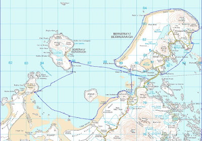
My very first post concerned a visit to Boreray. It is a beautiful island in a somewhat exposed position at the west end of the Sound of Harris in the Outer Hebrides. I also mentioned it in another post about clearing mink from the Western Isles.

Tonight I received an email from Jerry Cox who has been Boreray's sole resident since 1999. He told me about Boreray's website. I have no idea whether he has a satellite link to the internet like that on nearby Berneray or whether he has to leave Boreray and get access elsewhere. From the website, you can learn about the island and how Jerry makes a living from his croft which has a flock of St Kildan sheep. He also has a renovated croft house for rent. It has one of the most stunning views in the Hebrides. The only way of getting there is by kayak or Jerry's RIB. He warns "Please be aware that access involves a four-mile sea crossing in an open RIB with beach landing. Weather conditions may delay the start and/or finish of your stay!"


I would settle for a delayed departure.

Monday, January 08, 2007

A chilling winter warning.


In my post about winter paddling at Ayr yesterday, Squidink asked about the water temperature. By coincidence, Grazie who publishes Skoogle recently posted an index link to a post I made on the Sea section of the UK Rivers Guidebook forum last winter. I take the liberty of reposting here as cold water is probably the greatest threat to the safety of any sea kayaker.

A chilling winter warning.
December 2005. Regular readers of this forum will know of my concern for falling into cold water. I personally use a dry suit with pile/pertex underneath in winter if it is rough or a two piece bib with dry feet and a cag with latex wrist seals and a sealable neck in more moderate conditions. Under the two piece I use polartec aquashell garements which are made of micro fleece bonded to a breathable waterproof membrane equivalent to but much more comfortable than 3mm neoprene. I have practised falling in during winter and both of the above work.

However, I got a very bad shock last Saturday (at the end of December). My brother Donald did a lot of kayaking in the late 60's early 70's but had stopped until September when I took him out in my Alaw at Arisaig in September. He has had several major life events recently and he enjoyed the escape of kayaking so much he gave up smoking! I hadn't seen him since then till last weekend but he phoned very keen to go out again. The Accuweather upper Clyde sailing forecast was for a 6 mph northerly dropping to 3mph. The BBC forecast was for sun and 7 mph northerly winds.

I decided to go to Largs and take him across to the Cumbrae. I thought if the weather changed he could always get the ferry back. I decided not to bring my regular paddling partners Jennifer or Mike along as I wanted to be able to concentrate on Donald. We arrived at Largs in a flat calm just as the sun was coming up. We met Billy an experienced kayaker who was down to test his new paddle. We decided to head across to the Cumbrae ferry terminal.


I was very surprised how much weight Donald had put on since stopping smoking. I wished I had brought the Quest for him rather than the Alaw which had been a good fit in September. But we removed the hip shims, got the footplate right to the front and got him squeezed in and showed him how to release the nylon spraydeck.

FIRST MISTAKE

The Alaw was now too small for him. We should not have gone.

I had brought him a Yak salopette with velcro neoprene ankle seals and a Yak cag with velcro neoprene seals at wrists and neck. I had also brought my 3 mm neoprene shorty wetsuit and thermals for underneath but the wetsuit was far too small for him. He ended up with two Helly Hansen long johns, 1 Helly Hansen top with a micro fleece and a normal fleece under the Yak gear. I finished him off with Chota neoprene knee length boots, neoprene gloves and a neoprene cap. He complained he was too hot!

We were soon paddling over a glassy sea but a dark line on the horizon soon changed everything and we had a force 4 NW wind channelling straight down the Kyles of Bute meeting a spring flood tide.


Donald was really enjoying himself but I asked him if he would like to turn back. He definitely didn't!

SECOND MISTAKE
I should have turned back straight away as the weather was now out with his recent experience. As I have been sailing, windsurfing and kayaking at Largs since 1967, I had little excuse for not appreciating how local winds funnel and accelerate down through valleys in the hills and between the islands.

We were soon in the calm of the lee of Cumbrae and were enjoying a cup of hot soup. We were planning what to do next. I suggested heading south in the shelter of Cumbrae but the wind further out had now definitely dropped and Donald had caught a glimpse of the hills of Arran behind Cumbrae and fancied a quick look round the north of the island to get some photos.

Billy and I let him lead the way and told him we would turn back as soon as he felt uncomfortable. As we rounded the point, the wind was continuing to drop so we continued round.


We headed out from shore a bit to get the best view over to Arran. Unfortunately we had not gone much further when another dark squall line appeared on the horizon. This time we all decided to turn for the shore at the same time. But it was soon on us blowing about 4 to 5 and the seas built up very quickly. Donald found the following sea much more difficult and I saw him do a couple of successful low braces. I wondered if I should raft up with him.

THIRD MISTAKE. As soon as I saw him brace I should have rafted. As we approached the shore the waves steepened, he broached and fell in 190 metres from the shore.


He was disorientated and had the cold water gasp reflex but I was right beside him and got him to hang onto my bow. I got his boat emptied in seconds while Billy calmed him down. We then got him in between his boat and mine facing towards his bow. He was getting very cold and he was moving very clumsily. I have practiced getting big people into boats before and found the best way is between the hulls, arms over both boats, feet into cockpit and limbo forward. Donald got his legs into the cockpit but even with Billy and me on either side, he couldn't get his bum on the seat (a combination of being uncoordinated, weak and the seat back folding forward under his bum as the elastic was too stretchy).

A breaking wave washed over us and he was in again, looking even colder. I could see he was now mentally slowing down, his speech and movements were becoming uncoordinated. I looked at the shore it was just over 100m away. I shouted to Donald to grab the back of my boat (he had no strength left to get on the back deck of the boat) and shouted to Billy to keep an eye on him in case he couldn't hold on. I then paddled hard for the shore. The GPS data shows that it was only 7 minutes from the fall in to the shore.

He could hardly stand and the freezing north wind was blowing up the beach with no shelter and making him more hypothermic by the second (he had lost his neoprene ca)p. Now at last, some of the planning began to go right. I got him into my Vango emergency shelter. Billy and I got his wet clothes off and he put on the Buffalo pile and pertex jacket and trousers I always carry for such a situation. He then put the Yak suit and boots back on top together with a spare Lowe Alpine cap (fleece and pertex). With three of us in the shelter and three flasks of hot soup down our necks we soon had a warm fug but it was over half an hour before he got warm again.

Once he was warm enough he walked round the point to a sheltered bay on the east of the island and I towed his boat round. In the sun and shelter we had lunch washed down with more hot soup (we had 6 flasks between the 3 of us).


Donald (on the left) was soon back to form and even wanted to paddle back to Largs. We did have another spare change of clothing but he sensibly decided to take the ferry back and I towed his boat back to Largs.

What if we hadn't been near the shore? We would have to have used a scoop rescue (we had two hand pumps and a portable electric pump between us to empty the boat after this) but even with 2 experienced kayakers, we might have found it difficult to get him into the cockpit. Once he was in, one of us would then have needed to raft up with Donald while the other towed. (We have practiced this.)

What if we had not been able to self rescue? Well I had VHF, flares and EPIRB and Largs RNLI Inshore Rescue Boat station was only 2.6km away. But Billy and I (we are both doctors) were amazed at how quickly Donald developed symptoms of hypothermia (and he has much more natural insulation than a thin person). He could have been seriously hypothermic by the time outside help arrived.

Billy who was not any better dressed than Donald has now ordered polartec aquashell wear for under his cag and salopettes. The water in the Clyde is currently 11 degrees C and deep water off the West coast never gets warmer than 13 degrees even at the end of summer. In Spring it could have been even worse. The temperature in the West coast Scottish sea lochs is then only 6.5 degrees C even although the sun and air temp might tempt you to paddle in shirt sleeves.

In conclusion, learn from my three main mistakes above. Although we had a satisfactory outcome, prevention is always better than cure. Anticipate problems rather than react to them. Know that cold water is a killer.

It has not put Donald off sea kayaking but next time he will be in a dry suit, in a Quest and in a nice sheltered loch!

All the best for a happy and safe season in 2007.

Sunday, January 07, 2007

Auld Ayr


Auld Ayr, wham ne'er a town surpasses,
For honest men and bonie lasses.
-Tam o' Shanter. Robert Burns


Not very good photos today. The weather in the West of Scotland remains atrocious. David and I took the Aleut double out for a short afternoon paddle of 12km. We launched at Seafield at the south of Ayr beach and taking advantage of the spring tide paddled up the River Doon to the weir. We then paddled up the Ayr esplanade (the clapotis was vicious) to the mouth of the Ayr and paddled up to its weir. Negotiating the harbour mouth was a bit tricky what with the spring ebb holding up the swell entering from the Firth of Clyde.


The Auld Brig o' Ayr was built in 1232. It has outlasted several "New Brigs". In 1786 a new brig was constructed. Burns wrote a poem: "The Brigs of Ayr". In it, the Auld Brig prophesies to the New: "I'll be a brig when you're a shapeless cairn". TheNew Brig collapsed in 1877.

Saturday, January 06, 2007

Daft Anne's Steps, Hestan Island, the Solway Firth


Daft Anne's steps are a set of rocky pillars extending from the south of Hestan Island in the Solway Firth. In the Story of Hestan Island, published by Auchencairn History Society, Mark White gives the following account. Daft Anne was a person of weak intellect who lived in Auchencairn. In those days the tide in Auchencairn Bay went out further than today and it was possible (but not recommended) to cross from Balcary Point to the south side of Hestan Island at low tide. This saved a long trek round the north end of the bay to Almorness Point and the safer crossing to the north of the island. Needless to say, Daft Anne got drowned on the short crossing. The island has an automatic lighthouse perched on the top. It has two white flashes every 10 seconds and a range of 9 nautical miles.

We had great weather on our trip here in January 2005. I have just posted a full photo trip report over on the Scottish Sea Kayaking Photo Gallery. We saw blizzards of oystercatchers and two otters playing in the spring flood tide near Daft Anne's steps. The Solway is a great wintering area for many sea birds.

A rather distant otter with its head and tail just visible.

Friday, January 05, 2007

A matter of maps and rutters.


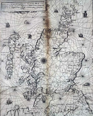
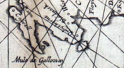
The Nicolay rutter was the first accurate chart and pilot for the Scottish coastline. (The word rutter comes from the French routier.) It was unsurpassed for accuracy for several hundred years. Those of you who know the Solway might question the island off Burrow Head to the east of the Mull of Galloway.


It is of course the Isle of Whithorn. Despite its name this is no longer an isle, but it was when the map was drawn. Even in the 18th century, there was still a channel at high tide and a smugglers' boat escaped the Excise cutter by sailing into the harbour and escaping through the channel while the cutter blocked the harbour entrance.

The rutter was created following an anticlockwise voyage round Scotland by King James V in 1540. The original manuscript was made by Alexander Lyndsay. It was made into a printed version in 1583 by Nicolas de Nicolay, a French map-maker. The National Library of Scotland has placed a digital copy on their website which can be zoomed to allow examination in detail.Only a few copies of the map survive and the BBC news reported that one is due to be auctioned on January 10th. I love looking at old maps and have a fair collection having inherited many old linen backed Ordnance Survey maps of Scotland (some from Victorian times) from by Grandfather. As the rutter is expected to fetch in excess of £20,000, I have decided not to place a bid on this occasion.

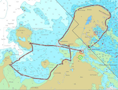
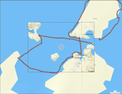
In addition to many paper maps and nautical charts I also have digital Ordnance Survey maps at 1:50,000 from Anquet maps. I bought all the 1:50,000 maps in the north half of Britain for £100. These can be viewed on the computer or dowloaded to a PocketPC. Unfortunately they can not be loaded into my Garmin mapping GPS unit but tracks from the GPS can be downloaded onto the computer and waypoints created in Anquet can be uploaded to the GPS. However, it is great for trip planning to be able to scroll seamlessly round the coast. You can print the map at the original size on A4 paper or you can zoom out to cram more coast onto your A4 or zoom in to make the area covered smaller but easier to read for older paddlers who do not wish to wear their reading specs.


Sometimes I laminate two maps back to back, sometimes I just keep them in the excellent Ortlieb map case.


For the Garmin GPSmap76cs I have two Bluechart regions:2EU006R and 2EUoo4R. These cost about £120 each. They cover from Corsewall Point to Spurn Head. As you zoom in on these you get more detail appearing as the product includes both large scale and small scale charts. They show the coast line in reasonable detail but very little on land. They are useful for showing water depth which can be a predictor for such things as turbulence in tidal channels. They also allow you to calculate tide times for a large number of ports. This works both on the computer and the GPS. Both Bluechart regions fit comfortably within the 115MB memory of the GPS.


For the Garmin GPSmap76cs to show contours on land and also more detail between HW and LW than the Bluecharts, I bought the Garmin Topo map of Scotland England and Wales for £130. This is based on the ordnance survey but has less detail of woodland, buildings etc but it does show roads. You cannot print from it and on the computer the size of the detailed screen is restricted. On the GPS unit it is very clear and is good for locating skerries, beaches and burns. The maps are large files so you have space to load only those of the general area you are heading for into the GPS, the whole country will not fit.


With regard to online maps, I like to use Streetmap in this blog to show the location of photos. It allows me to enter a grid reference from a paper map or Anquet computer map. Pasting the location url into a link in the blog allows readers to open the streetmap page then zoom and scroll.

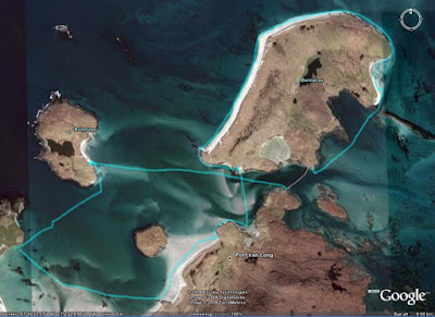
Another good online "map" is Google Earth. This can even import GPS tracks. Once I have the Google Earth window on the computer screen I save the screen to memory. (On a PC: SHIFT+Prt Scr)


Not all of Scotland has such good photos as this but for those areas with good coverage Google Earth can allow you to explore for campsites and can even show shallows.

It would appear that an advantage of being invaded by the USA is that Google Earth resolution dramatically increases. Ultimately, military use is what has driven the development of maps and also GPS. The British Ordnance Survey had its roots in the Jacobite Rebellion of 1745. In 1746, after the defeat of the Jacobites at Culloden, King George II of Great Britain commissioned William Roy to survey the Scottish Highlands for military purposes. Roy's name is engraved on the door of the Ordnance Survey headquarters in Southampton. Two centuries earlier, James V of Scotland commissioned his rutter to help quell the troublesome Lords of the Isles. The map was so strategic that it was obtained by the English who commissioned Nicolay to make printed copies; one of which was obtained by the French. They used it almost immediately to avenge the murder of Cardinal David Beaton of St Andrews who had been murdered during the Scottish Reformation.

What would Lindsay have made of Google Earth?

On 9/1/2008 Mark added:

"There is another way to get contour information onto a GPS without buying the TOPO maps. The necessary files, Contours v2, can be downloaded for free from the SMC website. You still need the Garmin software to get them on to the GPS itself but they are a big improvement on the Garmin base map.

It seems to work as a sort of overlay on the base map. This leads to some oddities such as sets of contours appearing where the base map shows sea but as the contours tend to be more accurate I have found that helpful as a kayaker!

They were put together by Dave Storey who must have spent a lot of time on it.

Not sure if I can post links here but I will try. The files are at http://www.smc.org.uk/ContourMaps.htm and there is a very helpful set of instructions at http://www.paulmac.force9.co.uk/geo/index.html.

Mark"