Imagine you are at the edge of the sea on a day when it is difficult to say where the land ends and the sea begins and where the sea ends and the sky begins. Sea kayaking lets you explore these and your own boundaries and broadens your horizons. Sea kayaking is the new mountaineering.
Tuesday, January 13, 2009
Sunset behind Mull
Leaving Bernera we made good time up the north west coast of Lismore. We were keen to reach Rubha Ban, the north west point of Lismore, before sunset.
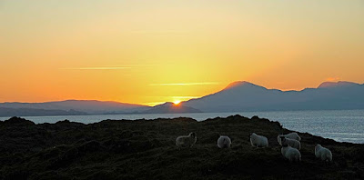
However, it was 9.5km to the point and the sun began to sink behind Bernera and the distant mountains of Mull while we were still afloat. We stopped and drifted while we photographed the magnificent sunset.
Alan and I put on a spurt to reach the headland...
...while Tony stopped off on little Eilean Loch Oscair. Whatever our viewpoint, it was a magnificent sunset behind Glas Bheinn (492m) on Mull.
This is the view that Tony saw. Remarkably there was a small flock of sheep on this tiny island. I do hope that they enjoyed each other's company, it's a long winter to be stuck on a rock!
Photo Tony Page.
We watched in silence till well after the sun had sunk below the horizon. It was nearly dark before Tony joined us at the point and we still had 5km to go back to Port Appin.
27/12/2008
Monday, January 12, 2009
Carry that weight on Lismore.
We landed on a delightful beach on Bernera. We had a second luncheon followed by a slumber in the golden sunlight as we waited for the tide to rise over the bar, which was blocking our way back homeward. Unfortunately the sun was now getting alarmingly low so we had to leave....
.... before Bernera was fully an island again. Tony and David carried the double over the still dry rocks. I, on the other hand, had to carry that weight of being expedition photographer! (With apologies to Paul McCartney)
27/12/2008
Sunday, January 11, 2009
Achadun Castle, Lismore
We were soon powering up Loch Linnhe and leaving the Sound of Mull in our wakes. We decided to cut another kilometer off our trip by cutting inside the tidal island of Bernera. If the tide was not sufficiently high then it would just mean another stop to watch it rise!
The inside passage also allowed a closer look at Achadun Castle on the SW of Lismore. This was built by the MacDougalls at the end of the 13th century. It passed to the Bishops of Argyll but was abandoned by them about the middle of the 15th century. It seems to have been disused since then.
27/12/2008
Saturday, January 10, 2009
Five Canada geese, four sleek kayaks, three lofty mountains, two light houses and a ..... Fiart!
After a calorific luncheon of Christmas cake we reluctantly left Eilean nan Gamhna and we were soon heading south towards the Sound of Mull. A skein of Canada geese flew overhead with whooshing wing beats. Our progress was not so rapid and it was obvious we would be returning in darkness again.
In the distance the MV Isle of Mull ferry entered the Sound of Mull on her way to Craignure between the Lady's Rock lighthouse and the the Eilean Musdile lighthouse. In the distance, the mountains of Mull soared up from the Sound.
As we were running out of time, we decided to cut through the narrow channel to the north of the lighthouse by Rubha Fiart. This would save 1.8km and after our recent trip round the Mull of Galloway, neither Tony nor I felt we had anything to prove.
As we entered the narrow channel at the south of Lismore, the tide had already turned. It was now flooding strongly and carried us westward towards distant Duart Castle on the south shore of the Sound of Mull.
We were now leaving the Lynn of Lorn and were soon expelled into the waters where the Sound of Mull joins the mouth of Loch Linnhe.
Feeling rather bloated after all this exertion, we drifted in the tide for a while...
... before digging our blades into the glassy waters on the way to our next stop on the tidal island of Bernera.
27/12/2008
Friday, January 09, 2009
Explorers and the rock tower of Eilean na Cloich.
This intriguing rock tower is on Eilean na Cloiche, one of a group of delightful islands in the Lynn of Lorne.
We stopped on nearby Eilean nan Gamhna to admire the view of the tower. It is backed by the distant mountains including snow flecked Bidean nam Bain, which is the highest mountain in Argyll and Ben Starav.
This view demanded a prolonged luncheon break.
The seakayakphoto.com staffers are hardened athletes in the peak of fitness. They put themselves through extremes of physical endurance and hardship (often in the depths of winter) in order to bring to you, dear readers, photos and tales of voyages to these distant places. In a word, they are explorers.
27/12/2008
Wednesday, January 07, 2009
Dun roving on Lismore!
Our recent trip to the delightful island of Lismore continued...
....with tidal assistance down a glassy Lynn of Lorn. The low winter sun slowly achieved its zenith as the ebb gathered its full flow.
Lismore is such a fertile isle that it was always seen as a prize in historical times. It has many defensive duns and castles of different ages and eleven are still named on the 1:50,000 OS map. This one is a Pictish broch called Tirefour Castle. It is probably about 2,500 years old. Originally it would have tapered upwards to about 7 times its current height but over the centuries its stones have been robbed for later buildings.
The tide carried us relentlessly onwards and the distant mountains of Mull appeared, rising steeply behind the gentler slopes of Lismore.
My goodness this was hungry work and after passing yet another dun, we spotted a lovely beach ahead on a little island called Eilean nan Gamhna. Time for a break!
27/12/2008
Tuesday, January 06, 2009
Nightfall over the Sound of Jura
As we left the MacCormaig islands, the clouds lifted just enough to reveal a dusting of snow on the Paps of Jura.
We landed on the rocky Tayvallich peninsula to catch the sunset, which proved to be a bit of a damp squib after all the crackers we have enjoyed recently.
To the north, the summits of the hills of Morven (where we had been the previous week) were still catching the last of the sun.
We made good use of the brisk tides in the Sound...
... this and the fact that the nights are now getting shorter meant we arrived back in Carsaig Bay before it was completely dark!
02/01/2009
Monday, January 05, 2009
Seakayakphoto.com trip index 2009
For those who would like to follow the thread of a single trip, I hope this index will be useful. Unfortunately the Google "search this blog" function is not working properly at the moment so the link may not recover all the relevent posts.
2009 running total distance: 890km
December:
The Cumbraes, Firth of Clyde, 27km
The Mull of Galloway tide race, at full belt! 21km
November:
Sannox synchronicity: Portencross to Brodick, Arran, 31km
Maidens to Ayr, 20km
October:
A trinity of tide races: circumnavigation of Scarba 38km
September:
Fleet bay Solway Firth, 3km
Islay, Oronsay, Colonsay, Jura, Islay 109km
August:
Seafield, Ayr, Firth of Clyde, 7km
Lady Isle, Troon Firth of Clyde 9km
June:
Ardnamurchan to Coll, Gunna and Tiree
Inner Hebrides
15/06/09 Coll to Ardnamurchan, 18km
14/06/09 Gunna to Rubha Sgor-innis, Coll, 34km
13/06/09 NW Coll to Scarinish, Tiree, 40km
12/06/09 Ardnamurchan to the Cairns of Coll, 28km
A Solway smugglers' Ccave
Fleet Bay
09/06/09 Solway Firth 9km
Full Moon at Rumblekirn
Fleet Bay
08/06/09 Solway Firth 14km
Sea shells and egg shells
Fleet Bay
01/06/09 am Solway Firth 10km
The great dun of Carrick
Fleet Bay
31/05/09 pm Solway Firth 19km
Three Pillars of Knockbrex
Fleet Bay
31/05/09 am Solway Firth 12km
Plumage and blossom on the Solway
Fleet Bay
30/05/09 Solway Firth 13km
Sea eagles and coral sands
Loch Eishort
23/05/09 Isle of Skye 19km
A big day!
Portuairk to Mull and return.
10/05/09 Ardnamurchan Point 42km.
Surf's up on Ayrshire's Atlantic Coast
Finnarts Bay to Lendalfoot
02/05/09 Firth of Clyde 21km
Arran Direct, Firth of Clyde
19/04/09 Kildonnan to Brodick 19km
18/04/09 Lendalfoot to Ailsa Craig then Pladda then Kildonnan, Arran 41km
Dumfries to Southerness in search of the Nith bore!
13/04/09 Solway Firth 25km
The Islands of Fleet
11/04/09 Solway Firth 12km
Fairlie to Little Cumbrae
04/04/09 Firth of Clyde 20km
The Islands of Fleet
02/04/09 Solway Firth 11km
Troon Ballast Bank to Lady Isle
01/04/09 Firth of Clyde 11km
From Portencross to Bute and Arran
21/03/09 Firth of Clyde 31km
"End of the Winter timetable!"
By ferry to Loch Ranza on Arran and return to Portavadie
19/03/09 Firth of Clyde 30km
The Carrick coast, Maidens to Ayr
15/03/09 Firth of Clyde 20km
The islands of Loch Leven
01/03/09 Firth of Lorn 11km
Port Appin to Loch Leven
28/02/09 Firth of Lorn 29km
"Any port in a storm on Great Cumbrae"
21/02/09 Firth of Clyde 19km
Bute from Seamill.
15/02/09 Firth of Clyde 23km
Surfing from Turnberry Point to Carrick Shore
08/01/09 Firth of Clyde 9km
The MacCormaig Islands from Carsaig Bay
02/01/09 The Sound of Jura 35km
A fine bothy for a party!
We circled round to the north side of Eilean Mor in the MacCormaig Isles and entered its surprisingly sheltered natural harbour. There is a seventh century turf roofed chapel, which we had explored on a previous visit but this time we wanted to get a closer look at a rather ancient looking turf roofed bothy on the west side of the inlet.
There was an awkward rocky landing at the foot of a steep stone flight of steps. We wondered if we were following in the footsteps of the saints!
Closer inspection of the bothy revealed an inset stone with Celtic carving. The word "Failte" (welcome) was inscribed above a shield device below which the date was a surprisingly recent 1995! Despite the inscription, the door was secured by two stout padlocks. It turns out that the island and the bothy belong to the Scottish National Party. Presumably admission is by Party card.
Somewhat disillusioned, we climbed back down to our waiting kayaks. Meanwhile the north going flood had built up nicely, promising a speedy return trip.
02/01/2009
Sunday, January 04, 2009
All kinds of everything on the way to Danna.
After our encounter with the otters we had a very brisk paddle into the teeth of a bitingly cold easterly wind.
Our destination was a sheltered beach at the south end of the island of Danna. It is a tidal island linked by a narrow causeway to the south end of the Tayvallich peninsula of Knapdale. Together with the MacCormaig Isles, it forms a site of special scientific interest (SSSI) noted for habitat, plants, birds and geology.
We had rather a hurried and cold luncheon and promised ourselves a further stop.
Our sights were on the gap between Eilean Ghamhna and conical Corr Eilean topped by its prehistoric cairn. There was a colony of very large grey seals basking on the rocks.
The next crossing to Eilean Mor was complicated by both wind and tide. Ahead of us, it got a little bumpy at the southern end of the island. You can just see the chapel and cross on the hill.
Round the corner all was calm again but we noted that the north going flood had already started over an hour before predicted. Tide times in the Sound of Jura are influenced by air pressure and we were in the middle of an unseasonal high.
With a fair tide and a little effort we got up to 13km/hour.
02/01/2009
Saturday, January 03, 2009
Tides and otters in the Sound of Jura.
We arrived at Carsaig Bay just as the sun was coming up. It was high water and all looked calm. The bay is a sheltered inlet off the Sound of Jura but across its mouth the waters surge back and forwards through the Dorus Mor and the Corryvreckan tide races at speeds of 4 to 9 knots. It is very helpful to consult a set of tide tables before launching here, unless one is prepared to enjoy a magical mystery tour to these two most interesting of sea kayaking destinations.
As it was, the ebb had just started and we were carried south to a group of most attractive islands. Here we are in the sheltered narrow channel between Eilean Traighe and Eilean Dubh.
Further on, the tide was running strongly through the channel between Eilean Fraoch and Eilean nan Coinean as we ferried across the narrow gap between them.
It was very pleasant having tidal assistance as we made our way down the rocky shore of the Sound of Jura at a steady 7-8km/hr with only light paddling.
As we neared the point of Rubha na Cille, we caught our first sight of our destination on the horizon, the MacCormaig Islands. We also spotted a disturbance in the water ahead. It was two young otters playing a pretty violent looking game of tag with one another. They were not particularly bothered by our presence!
02/01/2009
Friday, January 02, 2009
Catching the 08:15 for the MacCormaig Islands
Powerful spring tides drew us towards the inaccessible MacCormaig Islands. These tiny scraps of land, torn from the lands of Knapdale, are isolated by the swirling waters of the Sound of Jura.
Today we also had biting cold easterly winds which numbed our fingers.
We used the 08:15 ebb tide to carry us from Carsaig Bay down to the MacCormaigs. We then used the flood to carry us home. We covered 35km and, with tidal assistance, arrived home before dark, the first time in a while!
02/01/2009