Showing posts sorted by relevance for query "on location". Sort by date Show all posts

Friday, January 05, 2007

A matter of maps and rutters.


The Nicolay rutter was the first accurate chart and pilot for the Scottish coastline. (The word rutter comes from the French routier.) It was unsurpassed for accuracy for several hundred years. Those of you who know the Solway might question the island off Burrow Head to the east of the Mull of Galloway.


It is of course the Isle of Whithorn. Despite its name this is no longer an isle, but it was when the map was drawn. Even in the 18th century, there was still a channel at high tide and a smugglers' boat escaped the Excise cutter by sailing into the harbour and escaping through the channel while the cutter blocked the harbour entrance.

The rutter was created following an anticlockwise voyage round Scotland by King James V in 1540. The original manuscript was made by Alexander Lyndsay. It was made into a printed version in 1583 by Nicolas de Nicolay, a French map-maker. The National Library of Scotland has placed a digital copy on their website which can be zoomed to allow examination in detail.Only a few copies of the map survive and the BBC news reported that one is due to be auctioned on January 10th. I love looking at old maps and have a fair collection having inherited many old linen backed Ordnance Survey maps of Scotland (some from Victorian times) from by Grandfather. As the rutter is expected to fetch in excess of £20,000, I have decided not to place a bid on this occasion.

In addition to many paper maps and nautical charts I also have digital Ordnance Survey maps at 1:50,000 from Anquet maps. I bought all the 1:50,000 maps in the north half of Britain for £100. These can be viewed on the computer or dowloaded to a PocketPC. Unfortunately they can not be loaded into my Garmin mapping GPS unit but tracks from the GPS can be downloaded onto the computer and waypoints created in Anquet can be uploaded to the GPS. However, it is great for trip planning to be able to scroll seamlessly round the coast. You can print the map at the original size on A4 paper or you can zoom out to cram more coast onto your A4 or zoom in to make the area covered smaller but easier to read for older paddlers who do not wish to wear their reading specs.


Sometimes I laminate two maps back to back, sometimes I just keep them in the excellent Ortlieb map case.


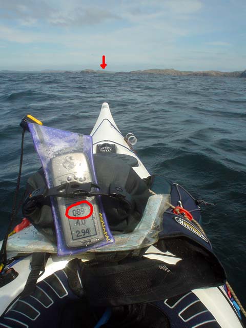
For the Garmin GPSmap76cs I have two Bluechart regions:2EU006R and 2EUoo4R. These cost about £120 each. They cover from Corsewall Point to Spurn Head. As you zoom in on these you get more detail appearing as the product includes both large scale and small scale charts. They show the coast line in reasonable detail but very little on land. They are useful for showing water depth which can be a predictor for such things as turbulence in tidal channels. They also allow you to calculate tide times for a large number of ports. This works both on the computer and the GPS. Both Bluechart regions fit comfortably within the 115MB memory of the GPS.


For the Garmin GPSmap76cs to show contours on land and also more detail between HW and LW than the Bluecharts, I bought the Garmin Topo map of Scotland England and Wales for £130. This is based on the ordnance survey but has less detail of woodland, buildings etc but it does show roads. You cannot print from it and on the computer the size of the detailed screen is restricted. On the GPS unit it is very clear and is good for locating skerries, beaches and burns. The maps are large files so you have space to load only those of the general area you are heading for into the GPS, the whole country will not fit.


With regard to online maps, I like to use Streetmap in this blog to show the location of photos. It allows me to enter a grid reference from a paper map or Anquet computer map. Pasting the location url into a link in the blog allows readers to open the streetmap page then zoom and scroll.

Another good online "map" is Google Earth. This can even import GPS tracks. Once I have the Google Earth window on the computer screen I save the screen to memory. (On a PC: SHIFT+Prt Scr)


Not all of Scotland has such good photos as this but for those areas with good coverage Google Earth can allow you to explore for campsites and can even show shallows.

It would appear that an advantage of being invaded by the USA is that Google Earth resolution dramatically increases. Ultimately, military use is what has driven the development of maps and also GPS. The British Ordnance Survey had its roots in the Jacobite Rebellion of 1745. In 1746, after the defeat of the Jacobites at Culloden, King George II of Great Britain commissioned William Roy to survey the Scottish Highlands for military purposes. Roy's name is engraved on the door of the Ordnance Survey headquarters in Southampton. Two centuries earlier, James V of Scotland commissioned his rutter to help quell the troublesome Lords of the Isles. The map was so strategic that it was obtained by the English who commissioned Nicolay to make printed copies; one of which was obtained by the French. They used it almost immediately to avenge the murder of Cardinal David Beaton of St Andrews who had been murdered during the Scottish Reformation.

What would Lindsay have made of Google Earth?

On 9/1/2008 Mark added:

"There is another way to get contour information onto a GPS without buying the TOPO maps. The necessary files, Contours v2, can be downloaded for free from the SMC website. You still need the Garmin software to get them on to the GPS itself but they are a big improvement on the Garmin base map.

It seems to work as a sort of overlay on the base map. This leads to some oddities such as sets of contours appearing where the base map shows sea but as the contours tend to be more accurate I have found that helpful as a kayaker!

They were put together by Dave Storey who must have spent a lot of time on it.

Not sure if I can post links here but I will try. The files are at http://www.smc.org.uk/ContourMaps.htm and there is a very helpful set of instructions at http://www.paulmac.force9.co.uk/geo/index.html.

Mark"

Tuesday, October 08, 2013

Campbeltown to Ardrossan via the Mull of Kintyre using a ferry and a portage.

This was a 200km 6 day trip taking the ferry from Ardrossan to Campbeltown then kayaking round the Mull of Kintyre to the surf beaches of Machrihanish and the Hebridean isles of Cara and Gigha before returning to the Clyde by West Loch Tarbert and portaging across the Kintyre peninsula to East Loch Tarbert in the Firth of Clyde. We then returned to Ardrossan via the mouth of Loch Fyne and the Firth of Clyde islands of Inchmarnock, Bute and Little Cumbrae.

Day 1. East coast of Kintyre

Single ticket to Campbeltown please.

A four pointed cross on a two pointed island.


Day 2. Mull of Kintyre to Cara.

An early start for the Mull of Kintyre.


Day 3. Cara and Gigha east coast.

Mistaken location of St Fionnlugh's chapel, Cara?


Day 4. Cara and Gigha west coast.

We had a swell time on Cara.


Day 5. Gigha to Ardlamont in the Firth of Clyde.

Much toing and froing on the crossing to West Loch Tarbert.


Day 6. Ardlamont to Ardrossan via Inchmarnock, Bute and Little Cumbrae.

Between a rock and a contrail on Ardlamont.


Tuesday, November 28, 2006

Courses, bearings and GPSs


Most sea kayak navigation is done by identifying coastal features, checking on the map where you are in relation to them then paddling towards the one you want to get to. However, fog, night or tide might make things more difficult. I used to be a Luddite when it came to GPS units and it is fair to say that although I am a technophile, I was a late GPS adopter.


In this case I want to paddle to the channel to the south of Pabbay Beag from Stacanan Neideaclibh. The horizon is pretty featureless so I can take a grid bearing off the map, convert it to a magnetic bearing and the course is 89 degrees between the two points. I now paddle on a heading of 89 degrees and I should get there. But if there is a tide carrying me north from the course line, my bearing to my destination will change to say 92 degrees. I will have no way of knowing this unless I have calculated the speed and direction of the current before hand or if I have identified a more distant landmark behind my destination and the two move relative to one another (this is called using a transit). In this case there is no suitable transit landmarks.

This is where a GPS comes in. I set a waypoint in its memory for the place I want to get to by either; 1. entering a grid reference, 2. on a mapping GPS scrolling the pointer to the map position then pressing the MARK key or 3. if I was there earlier in the day, by pressing the MARK key when I was in the middle of the channel.

Next I press the FIND key and select the waypoint. The GPS then calculates the distance and course from your start location. Most GPS units have a GOTO page which displays a large arrow which points on a compass rose to the bearing from your current location to your destination. If you drift off course then the bearing changes. On simple GPS units the bearing pointer points to the top of the screen if you are on course. On more sophisticated units the bearing pointer will point to the destination if it is held flat. This is all pretty complicated to describe and in practice in rough water and if your eyesight is not very good, you will end up a long way off course before you detect the change in the bearing arrow.
In practice it is easier to monitor any change in the bearing as a number. On my Garmin GPSMap76cs I can set the bearing to the destination on a large type screen as a number. This is very easy to see especially for those elder paddlers whose close up vision is no longer what it was. If the tide carries me off course to the north, the bearing might Increase to 92 degrees. I now paddle more to the rIght and the bearing comes back to the course of 89 degrees. If I was carried off course to the south, the bearing might dEcrease to 86 degrees. I now paddle more to the lEft and the bearing comes back to the course of 89 degrees. In practice it is easy to keep within about one degree of the course on typical sea kayaking distances.

The GPS allows you to maintain a perfect ferry angle despite changing tidal flows. This is a function that map, compass, tide tables, chart and your brain would be unable to match. Off course it needs to be used sensibly. If you are crossing a channel and expect to be half way across at the turn of the tide, you may as well paddle straight across on a constant bearing and allow yourself to be carried down tide then up tide and these will cancel each other out and you will not waste time ferrying into the tide. Another point is that GPS units can be set to use various Norths such as grid and magnetic. I always set mine to magnetic so that if the GPS fails I can just switch straight back to the compass.

I explained all this to a friend who is very keen on skin on frame kayaks and Greenland paddles. He was rather dismissive of all this technology and wondered what was wrong with a good old compass. However, I am pretty sure the Inuit did not have compasses (not to mention aluminium frames and polymer skins).

PS in response to Cailean's reply.

In May I was fortunate enough to be part of a group that was led out to the Ecrehouse reef which lies 10 km off Jersey in the path of tidal currents that run up to 5 knots.


The leader was a very experienced local paddler who had been out to the reef countless times. He used local knowledge, his experience, compass, map, tide tables and tidal flow charts to take us out by the southerly route above. It was a safe crossing and allowed us to get carried down onto the Ecrehouse. If we had missed it we would have ended up going to England. However, we battled for 2 km more than we had to into a 3.5-5 knot current which was extremely tiring and a couple of paddlers in the group were very nearly exhausted by the crossing. The leader knew I had a GPS and asked how we were doing at the point we changed direction.

If we had done this crossing using the GPS then I would have set a waypoint about 1 km up tide of the Ecrehouse (at our final change of direction on the chart above) and we would have paddled straight to it.

I do think that being able to ferry at just the right angle using a GPS can conserve a groups' energy to leave a reserve for any unexpected tide or wind conditions they might meet later.
Here is a GPS track of a trip to Ghigha. On the way out it was flat calm and slack water. On the way back there was a 2 knot north flowing tide and a force 6 southerly wind. I used the GPS track not to navigate such a short crossing but to adjust the ferry angle. As you can see it was an efficient crossing in somewhat lively conditions!

Sunday, December 31, 2017

Our sea kayaking pilgrimage comes to a peaceful end in Oronsay Priory

As we made our way up from the beach  David had a spring in his step which was quite unlike thast of his first visit some years ago. I had told him that we were going to visit the Priory. He visibly paled before he said "Is that wise? They'll never let us out, we'll need to go into rehab and walk the twelve steps!"

As we made our way over the machair towards...

...Oronsay House we were intercepted by the RSPB warden. Straight away I asked how his nettle patches were growing? He then knew that we were aware that Oronsay was an important reserve for corncrakes. He told us that there were presently three calling males on the island but unfortunately we did not hear them on our visit. Another reason the wardens rush up to meet visiting sea kayakers is that they do not want you to camp on the island. My friend Tony stood his ground when approached by a previous warden several years ago. He was camped on the east of the island well away from areas used by corncrakes and choughs, which are the species the RSPB is most interested in.

Under the terms of the Land Reform Act (Scotland) you can visit and camp on Oronsay provided you avoid disturbing the birds (or other wildlife). The RSPB website still encourages visitors to visit their other reserve Loch Gruinart on Islay instead: "This site is one of several that due to its size, location and/or conservation sensitivity is not capable of accommodating large numbers of visitors (unless stated). Where possible, we have indicated the nearest equivalent RSPB nature reserve (Loch Gruinart) suitable for visiting."

Fortunately, they now have a rider at the bottom of the page which recognises your legal right to access the island: "This does not affect any statutory rights of access under the Countryside and Rights of Way Act or Land Reform (Scotland) Act legislation".

I joined the RSPB in 1973 when I started work as a ranger/naturalist with the National Trust for Scotland. Although I was a member for several decades, I left when it became clear their aim was to restrict public access to their reserve land.

Anyway the RSPB do not own Oronsay. The island belongs to a delightful American lady, Mrs Colburn, who we have found to be most welcoming of visitors. Indeed on our last visit we met her on the beach and helped her clear up plastic flotsam and jetsam.

As we passed her lovely house on the way to the Priory she waved to us from the window.

Oronsay Priory is situated where the machair abuts the foot of a rocky crag (where you maybe lucky and see choughs). A deep sense of peace pervades this place and it is no wonder that a religious settlement was set up here, far from the turmoil, violence, warfare and lawlessness that plagued most of Scotland throughout the Dark Ages and Mediaeval Times.  These buildings date from the mid 1300's but there may have been a chapel here since St Columba's time. The Priory was founded by the Lords of the Isles and became a centre for religious sculpture until about 1500.

The sandy machair soil of Oronsay lent itself to easy grave digging and there were no wolves on Oronsay to dig up recently buried corpses. So Oronsay became both a place of religious pilgrimage and a final resting place.  Many of those interred here were former pilgrims or residents of Argyll on the mainland or like this recent grave, drowned sailors whose bodies were washed ashore. You can read more about some interesting graves on Oronsay in this post from our previous visit.

Some say St Oran gave his name to Oronsay but I rather doubt this as Oronsay is quite a common name for tidal islands on the west coast. It comes from the Old Norse and means "island of the ebb tide" which is exactly what Oronsay is. You can walk to it from neighbouring Colonsay at low tide.

Undoubtedly the most impressive features of the graveyard are its two standing crosses. This is the Great Cross of Oronsay, which stands inconspicuously against the farm buildings at the back of the Priory graveyard. It is finely carved on both sides and is thought to have come from Iona.

Although it has withstood over 5 centuries of weathering, you can still see how finely the east face of the cross was carved.

The west face of the cross is also finely carved and at...

...its base is a Latin inscription. It was carved for Malcolm MacDuffie, the Lord of Colonsay, some time after 1472 and erected before 1500.

+HEC EST CR/UX COLINI F/ILII CRISTI/NI M(EIC)DUFACI
'This is the cross of Colinus (Malcolm), son of Christinus MacDuffie

Another interesting, but older, cross stands on a little knoll to the east of the Priory. In 1881 just the shaft was standing and the present head of the cross lay on the ground beside it.

There is some doubt as to whether this is the original head of the cross but it has now been replaced atop the shaft.

It is decorated by a rather portly and smiling figure. Perhaps life was good here when the cross was carved.


The Priory is one of the best preserved medieval religious buildings in Scotland. It was too remote to be destroyed in the Reformation, as were many of its more accessible, contemporary religious buildings. We entered the interior of the Priory to find ourselves in a...


...cloistered courtyard. Someone was lying in peaceful contemplation...

...it turned out to be Sam who, without a sail, must have been quite exhausted keeping up with the paddle sailors who had enjoyed a fair wind on the long crossing from Jura.

Like pilgrims of old, I think all of us particularly appreciated our visit to this special place because of the effort it had taken to get here. We left Sam to his well deserved rest and made our way to the back door of the Priory which...

...to David's great relief was not locked.

As we made our way back into the graveyard we passed below...

..the great east window of the chapel which must have been magnificent when it was filled with stained glass.

As we took our final steps at the end of our personal pilgrimage to the Priory on Oronsay we reflected on those who had led their lives here and kept human decency, hope and faith alive through the darkest centuries of Scotland's bloody past. Whether or not you are Christian, or even of any religious persuasion, I suspect that if you ever visit this place, you would set off on your road home inspired to help in your own way to make the World a better and more peaceful place for all its inhabitants.

Far from the Peace of Oronsay and away to the east, beyond the Paps of Jura, lie the lands that inspired Christianity, Judaism and Islam. It is a sad paradox that many lives in those lands that were at one time the cradle of civilisation are currently blighted by senseless violence and destruction.

You can read Ian's account here.

Saturday, July 06, 2013

Mistaken location of St Fionnlugh's chapel, Cara?

Having arrived on Cara a day early we thought we might have a long lie but...

...our new neighbours had other ideas and low flying Canada geese can express their ideas very vocally. They started about 5am...

 The early summer flora was more laid back...

 ...and we set off to explore Cara on a path through the bluebells which...

 ...led to Cara House.

 First we inspected the old building to the NE of the house and found that the mortar that bound its ancient stones together...

 ...had been made from sand from the shore. Sea shells were clearly visible. This building looks very much like the mediaevel chapel of Cara. The chapel was dedicated to St Fionnlugh who was a contemporary of St Columba. The OS map, Hamish Haswell-Smith and Canmore all give the location of the chapel as a pile of stones to the SW of Cara house. However, the photograph in Canmore is quite clearly of this building by the house. Also Old Statistical Account (1793) description (quoted by Haswell-Smith) describes lancet-shaped windows with splayed inshots in the east ends of the side walls, which this building has....

Looking from the entrance in the south wall to the splayed inshot window at the east end of the north wall.

The chapel was also latterly used as a kitchen for Cara house and the pile of stones on the OS map is rather far to be convenient for the house. Also, although the pin on the Canmore map points to the OS "chapel", the 10 digit OS grid given by Canmore points to this building.

The corner of the sheep pen marked on the O map as the chapel.

Haswell-Smith himself says that the the OS "chapel" could easily be mistaken for a sheep pen. I think the stone structure to the SW of Cara House was a sheep pen. It measures some 30 yards by 4.5 yards and according to the OSA the chapel measured some 9yards by 6yards which are the measurements of the building on the NE side of the house. So based on the description of the Old Statistical Account of Scotland, the building close to the NE of the house was the chapel.

Cara House was built in 1733 by the Macdonalds of Largie for their tacksman. It was last used by a resident on Cara in the 1940's when the tennant farmer left.

It is rather grim looking and I am not surprised that the spirit of The Brownie has taken up residence there.

Despite The Brownie's presence Cara House was renovated as a holiday home in the 1990's.

We left Cara House to the hopefully sleeping Brownie and pressed on through the bluebells.