Friday, July 08, 2011

Sea kayaking the SW and W coasts of Hirta, St Kilda

The SW coast of Hirta falls sheer into the sea. Despite the sea level being unchanged for about 6,000 years and being exposed to one of the greatest average wave energies in the British Isles, there is no wave cut platform though there are many geos, arches and caves.

We were paddling NW towards the gap between Soay and Hirta, where we had arranged a rendezvous with the MV Cuma.

It was too rough for even Gordon to paddle through the arch at the foot of Mullach Bi (which we had looked down upon the previous day). However, Gordon and Callum went through a gap in the skerries, which had monstrous swells breaking through.

This wasn't enough for Gordon so he found an offshore skerry with a gap...

...that had jagged teeth at the bottom. After studying it for a while, he nipped round the outside...

...then successfully powered through before...

...the swell receded revealing those teeth.

Turning a corner, we now paddled below the equally dramatic west coast of Hirta.

Ken was doing a lot of paddling in the double as Simon, up front, shouted directions as he filmed our progress.

We now approached Soay Sound and we could see Murdani in the Cuma scouting the conditions beyond the stacs.

We had arrived early because the swell had precluded detailed exploration of all the arches and caves.

Murdani had judged that the tide race through the gaps between Soay, Stac Biorach 73m, Soay Stac 61m and An Campar 270m on Hirta was not still not conducive to safe sea kayaking. So he motored over to the SE coast of Soay and prepared a lunch for us while we waited for slack water by the stacs. One by one, we paddled across Soay Sound towards the Cuma.

Ian enjoys paddling the Etain in front of Soay Stac, on the way to a luncheon stop with a difference!.

Thursday, July 07, 2011

Escape from the bustle of Hirta; by sea kayak through Dun!


On the morning of 14th June, Village Bay, Hirta was a noisy, busy place. First the peace was disturbed by the rumbling diesel of L105 HMAV Arromanches arriving with a load of oil for the power station. Then the interminable Health and Safety reversing beeper of St Kilda's heavy tractor echoed round the hills.

The "beep beep beep" was then joined by a "whup whup whup" as PGD helicopters' G-PDGN (a Eurocopter AS365N Dauphin 2) brought in Qinetiq workers  and supplies for the base and prepared to take relieved workers and the mail out.

In comparison our departure was in near silence. The weather was fair but the forecast was for a front to come in from the SW by late afternoon with force 4 to 5 winds and increasing swell.

So we wasted no time and quickly passed the Dun Gap...

...on our way to Seilg Geodha. This cave system goes right through Dun and two days before we had entered from the other side  but were unable to get through the slot due to swell from the NE.

This time we got through the slot into the main cavern where we had been before but frustratingly heavy swell, this time from the SW, meant we could not get right through again!

We emerged back into the calm of Village Bay...

...then made our way in increasing swell towards...

...the Great Arch of Dun. This is looking through towards the SW. The photo makes it look as flat as a pancake but this is a huge arch and the scale swamps the size of the swell. This was bouncing back off the right hand wall and breaking over a shallow reef that lies right in the middle of the channel.

With some careful timing...

...the passage through the arch was successfully negotiated....

...and we made our way along the SW coast of Dun.

The swell increased...

...as we approached the Dun Gap. Gordon made the most of the swell wrapping round Cul Cleite. We had now completed our exploration of Dun and were about to experience the exposed SW coast of Hirta!

Wednesday, July 06, 2011

When you're dun roamin' on Hirta, get yourself a plot on Dun!

From the heights of Ruabhal on the southern tip of Hirta, we looked down over Caolas Dun to the magnificent island of Dun. The Dun gap was unusually calm and quite unlike the previous evening, when we had paddled through it in both directions.

We sat for a while mesmerised by the stark grandeur of the scene before us. The shadows had lengthened by the time we felt ready to leave. Now my problems started. I was faced by a steep traversing descent back to Village Bay. My knee was now causing me a quite a bit of pain. I couldn't keep up with the others but Gordon was happy to keep me company on the way back which was very appreciated.

While enjoying a chat we came across the main mast of the yawl Avocet above the storm beach in Village Bay. She was wrecked here in June 1960 and has clearly seen better days.

Walking back to the pier we passed the International Sea and Airport Lounge. If you are ever ship wrecked on St Kilda, make your way here it is lovely and warm inside!

That night after enjoying another slap up meal on the Cuma, we watched the sun set over Dun. The low rays revealed the presence...

...of lazy beds high on the slopes of Dun. At 9pm the midsummer sun was still shining on them despite the whole of the Village Bay area being in shade. Survival on St Kilda was on a knife edge. That little bit of sun probably made the difference on whether your vegetables ripened or not. Even though a boat journey and difficult rocky landing were required to reach those vegetables, this would have been a prime plot!

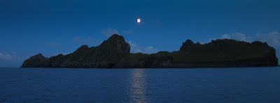
As we chatted away on Cuma the sun light faded and a near full moon rose above Bioda Mor, 178m, the summit of Dun.

As the moon traversed the sky above the ragged outline of Dun, we knew there would be a big spring tide to negotiate in the Caolas Soay the following day.

Tuesday, July 05, 2011

Three stones and a duck on Hirta.

From the head wall of Gleann Mor we made for the precipitous SW coast of Hirta. I wanted to see the Lover's Stone. A potential bridegroom reputedly had to balance on the edge of this 45 degree slab that rises above the drop below. Possibly it was just a story for the Victorian tourists, but it was a good one. Unfortunately my knee was by now hurting a bit and I did not fancy scrambling down for an inspection! However it was a great viewpoint to see the cliffs of Mullach Bi, 358m.

At the foot of Mullach Bi a long arch, Geo Creag an Arpaid effectively links the W and SW coasts of Hirta. We were able to paddle through this on our 2008 trip. We hoped to do the same on this trip!


Some people believe that St Kilda escaped glaciation. We found several places on the ridge between Mullach Bi and Claigeann Mor where rocks and stones showed striations that looked very typical of striations made by a glacier.

The tors of Claigeann Mor were rather rocky so while some of the others scrambled the ridge, I was happy to stick to the grassy slope behind.

From here we got a great view of the Ruabhal peninsula, the southern tip of Hirta, with Dun behind.

Rather than contour round the steep slopes, we rejoined the island's service road, on the branch that leads to Mullach Sgar. From this angle a grassy slope leads to the rocky tor on the summit of Ruabhal, 130m. We thought this would have a great view of Dun behind.

This is the site of yet another of Hirta's prenuptial stones; the Mistress Stone.

 I was quite happy to watch while the other's scrambled up to try their mettle...

 ...there was an easy way round the back!

With a knee like mine, there was no way I was going to balance on the edge!

Amazingly, Mistress Eider Duck, had chosen this very spot for her nest. Murdani, the captain of the Cuma, told us that she had been nesting here every year, for at least the last 8 years! I wonder how her ducklings make their way to the sea, off the Mistress Stone?

Saturday, July 02, 2011

Hirta, an island of two valleys.

As we made our way down  the south ridge of Mullach Mor from the radar station...

...we got a great, bonxie's eye view of the valley down to the Village Bay area and the open ocean beyond. Away to the SE, the great stac of Levenish seemed to float above the sea.

As we descended further, we could make out every detail in the Village; the whitewashed factor's house, the curving street, the circular wall of the cemetery and the head wall that ran right round the hill side of the village were all clear. It was strange to think that this was about as much of the World as the vast majority of St Kildans ever saw.

We now made our  round the headwall...

...of Gleann Mor, the valley...

...on the NW side of Hirta. This glen was probably permanently inhabited up until 1,000 years ago when the climate was better. In more recent centuries it was inhabited only in summer. An ancient Iron Age wheelhouse, called the Amazon's House by Martin Martin in 1695, lies beneath the radar station on the slopes of Mullach Mor. The Amazon was a mythological female warrior/hunter who roamed the great lands that in legend used to connect Harris to St Kilda before sinking beneath the waves of the Atlantic.


Friday, July 01, 2011

St Kildavision, the movie!

The reason we got together to go to StKilda was to provide footage for the trip element of the second Sea Kayak with Gordon Brown DVD.

I hope you have been enjoying the StKilda Stereovision experience by following this trip, to the Islands at the Edge of the World,  from two different perspectives. You can follow our adventure both on Ian's blog and on this blog. Well now you can experience it in full St Kildavision in Simon's Video Diary teaser...

St Kilda Sea Kayaking, Video Diary 3 from Simon Willis on Vimeo.