Showing posts with label weather. Show all posts

Monday, June 11, 2012

The pleasure of weighing anchor in your own backyard.

As we waited at Brodick pier for the ferry back to Ardrossan, there was a change in the air. High cirrus clouds streaked across the sky...

...and at lower level, thick clouds from the NW spilled over the rocky ridges of Arran.
 
The MV Caledonian Isles arrived bang on time and...

...we trollied our kayaks onto the car deck. Before we left Brodick, we were in the cafeteria enjoying chicen patia, rice and nan bread washed down with some Arran Blonde Ale.

We had just not long left Brodick, when the forecast wind suddenly got up with a vengeance. We were very glad we had left Kildonan early that morning. This NW wind also explained the increasing northerly swell we had encountered after leaving Holy Island.

As we approached Ardrossan, the ship's Tannoy announced "Would all drivers and their passengers please return to the car deck." We assumed that this included kayakers.

All too soon we were back in the car park and our Arran adventure was well and truly over.

136km may not sound much as great expeditions go, but for us it was a wonderful escape. It was one of the best holidays we had ever had and all the sweeter as it was in our own backyard. It was also in the land of our ancestors!

Monday, February 06, 2012

Gardskagi, Do not roll!

 The wind continued to increase...

 ...so we nosed into a sea loch for a bit of shelter.

We were not the first to seek shelter here...

...Ian noticed a strange object on shore.

It was Gardskagi: 64⁰02,57N 22⁰55,93V I thought it was a Dutch weather buoy, given the manufacturer's stamp, "Datawell Netherlands", but JotM has identified the language of the coordinates as Danish..

It was over 1200km out of position. Its normal station is off the SW tip of Iceland.

It had some good advice on the top. Do not roll - trail only. We pondered these words of wisdom.

Tuesday, September 06, 2011

Any port in a storm.

As Jim and I approached Garroch Head on Bute, we were looking for a suitable spot to have a second luncheon...

... and perhaps to weather out a thunderstorm, which threatened to spill over the Sound of Bute from Arran.

 We found this little cobble beach...

...in a break in the lava beds of Garroch Head.

The lava bed rock had been worn into amazing pinnacles and channels by a combination of wave action and the cobbles.

 We enjoyed the view...

 from a little platform...

...above the beach. We wondered how many of our fellow seafarers and ancestors had been grateful for the shelter offered by this little beach if caught out in a storm.

 However HMS Dragon seemed unperturbed by the weather...

...and at last the sun broke through and shone down on Gen Sannox again. It was time to move on.

Monday, February 14, 2011

Ready for some windy fun on the Clyde.

Saturday's XC weather, forecast for Troon.

Saturday's MagicSeaweed, surf forecast for Machrihanish.

Saturday's forecast for Troon, in the Firth of Clyde, showed that the predicted gales were not expected to arrive until well into Saturday evening. The surf at Machrihanish was predicted to be 9.5 feet in advance of the arrival of the approaching Atlantic low pressure system. Tony and I decided to nip out to Lady Isle, which lies about 4km off Troon Point. However, rather than launch at Troon, we decided to take advantage of the southerly winds and swell and a flood tide and so launched a little further south than Troon....


...some 30km south to be precise! Nonetheless, we reckoned we could still be off the water by the back of 4pm, before the worst of the wind arrived!

Using a car or a ferry to get upwind before a downwind paddle may not be very environmentally friendly but it sure is a lot of fun! Tony's wife kindly dropped us off at the Swan Pond car park in Culzean Country Park and we trollied our kayaks down to Maidenhead Bay. Tony's dog, Bob, was extremely reluctant to be left behind and ran out onto the rocks of Barwhin Point, where he leapt onto Tony's rear deck as we passed by. Unfortunately he slid off the other side. It's just as well he likes a swim.

Leaving Barwhin Point and Turnberry lighthouse behind us, swell was already making its way up the Firth of Clyde.


 The sun soon broke through the morning cloud and mist and...

...by the time we stopped for first luncheon, at the north end of Culzean Bay, we were in full winter sun. Overheard, parallel streams of cirrus clouds in the jet stream predicted bad weather in 12-36 hours...

...so my Flat Earth sail was rigged and ready for some action!

Saturday, June 26, 2010

Trouble in the Isles

The Scottish tourist board have been hoping for a record breaking tourist season. What with the recession, volcano dust interrupting plane flights and the exceptionally dry June here in Scotland, things were looking promising....


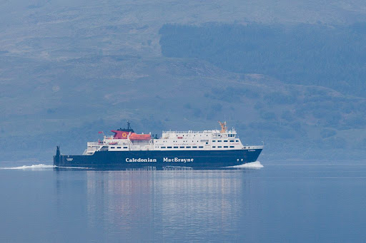
This is the MV Clansman, she is one of the hardest working ferries in the Calmac fleet. It is 0743am and she is steaming out through the Sound of Mull towards Coll, Tiree then back to Coll. After visiting the islands she will return to Oban for a mere 40 minutes before heading back through the Sound of Mull and out to Castlebay in Barra! She is known as the loudest vessel in the Calmac fleet. We were camping at the SE entrance to the Sound of Mull but woke up when she started her engines 18km away in Oban! Sadly she has suffered a catastrophic engine failure and the life line she provides to Coll, Tiree, Barra and South Uist has been disrupted.


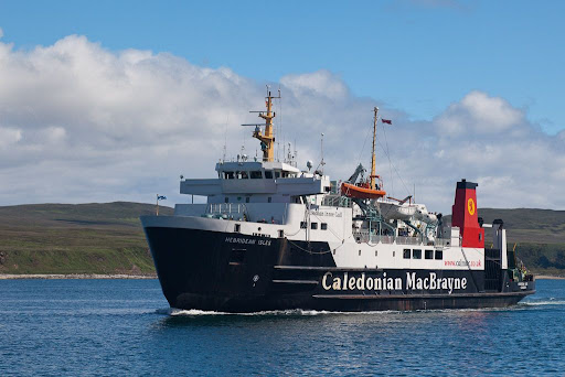
To maintain service, Calmac have transferred the MV Hebridean Isles, which normally does the Kintyre, Islay, Colonsay, Oban run, to help cover the Clansman's normal routes.


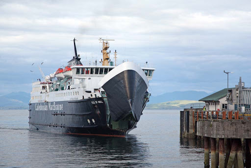
The MV Isle of Mull, which normally does the Oban to Mull run has also been drafted in to help cover the Clansman. The effect of this is that services to Islay, Colonsay, Mull, Coll, Tiree, Barra and South Uist are all affected. To make matters worse, the Scottish school holidays have just started.

If this was not enough, the record dry June has left reservoirs depleted in what are some of the wettest parts of the world! We now have an almost unbelievable situation where Mull is having to import water at a time when the ferries have restricted sailings!

As we say in Scotland, "It never rains but it pours!"

Saturday, May 08, 2010

What a geo on Oa!


Soldier's Rock was barely out of our minds before we discovered the NW headland of the Oa peninsula on Islay was riven with a series of deep geos culminating in this one. It stretched for 100m, deep into the rocks and culminated in a slight opening with a steep beach behind. A lazy three foot swell was running into the geo and crashing on the steep beach in dumping surf. The repeated low BOOOMPHS reverberated along the narrow channel. We chose not to risk landing in this isolated spot and turned carefully just on the edge of the surf line and made our way back out towards the light and the open sea beyond. The hail had turned to rain but by the time we emerged it had turned to snow carried by a cold wind from the north.

We were now only 2.5km from our end point at Kintra. We had planned to stop for a well deserved second luncheon at the delightful little Port Alsaig but despite being ravenous, we decided to press on in the snowstorm.


We landed below Kintra farm at the south end of the Big Strand. This beach is the biggest on Islay and its sands stretch away for over 8km along the east shore of Loch Indaal. We were ravenous but there was little shelter in this open place so we ate our sandwiches as the snow fell. Misha had the biggest sandwich bag and ate it all! We recounted the highlights of our day as the snow fell and the light faded.


"The dolphins were this close!"


"Get away!"

What another great trip... the only fly in the ointment was that my car was 7km away at Port Ellen!

Tuesday, May 04, 2010

The most southerly Gargoyles in all of the Hebrides


It was pouring with rain when we left the beach below Lower Killeyan.


The mist came right in and obscured the far side of Loch Indaal, leaving the dark shapes of the stacks isolated from the rest of the landscape.


It was an eerie feeling to be paddling in such an isolated environment as we lost sight of each other in the vonvoluted rocky channels between the cliffs and stacks.


From the headland north of the beach we looked northwards to a series of bold headlands, one after the other, culminating in Dun Mor Ghil in the distance.


A little later, we looked back, from just south of Dun Mor Ghil, to the monument on the now distant Mull of Oa which still towered above the intervening sea stacks.


Rocky gargoyles looked down on us from the rain soaked heights of Dun Mor Ghil.


Back at sea level, partially submerged rocks betrayed the strength of the current in these parts, indeed, some of the headlands required a determined effort to pass.

It might have been raining, but we knew we were in sea kayaking heaven, here on Islay's Oa peninsula, the most southerly point in all of the Hebrides.

Monday, April 12, 2010

A Galloway snow squall warning


Although we had driven through snowshowers on the way to Portpatrick, we launched under clear blue skies. We soon found ourselves in the shade.


Making our way to the SE along the cliffs of Tandoo Point on the Rhins of Galloway, the skies darkened...


...as a great snow squall raced across the land and out to sea. This was a trip that could go either way...

Thursday, August 20, 2009

A fair wind below Goatfell


We left Sannox Bay in glorious sunshine. The tight little low that had brought a front and SW/W winds had now passed to the east of us and the wind had veered to the NW.


This was just perfect for blowing us all the way down the NE coast of Arran. In the distance, Holy Island's Mullach Mor, 314m, rose above the eastern point of Arran
.

We made good speed under Arran's rocky ridges.


The ridges culminated in Goatfell, 874m, which is the highest peak on Arran.

21/03/2009