Showing posts with label waterfalls. Show all posts

Wednesday, November 25, 2015

A race against the tide at Corbies Cove.

As we left Murray's Isles the temperature had risen noticeably and there was a line of blue sky approaching from the south.

 We were paddle sailing for Ravenshall Point on the NE shore of Wigtown Bay.

 As we crossed Fleet Bay we became rather warm in our dry suits so...

 ...we were on the lookout for somewhere to land and change into something cooler. The coast here is seldom visited but the main A75 road runs along a raised beach at the the top of the cliffs.

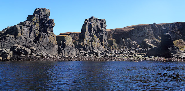
 We found a little gap in the rocks at Corbies Cove where a burn tumbled down from the cliffs above,

 The beach was disappearing fast in the Solway flood tide so it was a race to get changed. The water was literally lapping round our feet as we got changed.

This was another stunningly beautiful spot. It seemed a long way back to Ringdoo and Borness Points which were just visible on the horizon and which we had rounded the previous evening. The sky was now almost completely clear and despite being mid October it was getting hot!

Tuesday, June 02, 2015

Waiting for the tide in the Sound of Islay #2 Jura adventure at Allt Bun an Eas!

After picking the ticks off our ankles and wrists we tucked our trousers inside our socks. We still had plenty of time before the tide turned in the Sound of Islay. We fancied talking a walk back along the shore....
...to the waterfalls we had seen earlier. At first I was not sure I would make it that far as my knees were painful in particular my right knee. However on the descent off the grassy slope behind the basalt dyke something deep inside my knee clicked. Suddenly it was less painful and much easier to move.

 So Tony and I set off along an amazing beach, under Beinn an Oir 785m, to the...

 ...waterfalls at Allt Bun an Eas (burn with the waterfall at the bottom). The final fall cascades into a pool on the beach itself.

I had climbed up here (before knee problems) on a visit with Phil and there are three more fabulous pools above the large pool at the bottom of the falls. Each is more difficult to reach than the one before. There are big jug handle holds and Tony soon made his way up. It looks very steep but the first step was only about 25 degrees.

I was just going to stay at the bottom but my knee was still nice and loose so I could not resist and was soon up the first rock step to the second pool. Tony was now up at the third pool and shouted down that it was completely stunning.

Unfortunately it was at this point that my right knee clicked again and I had sudden stabbing pain. Ouch! Stunning pool or not I was going no further so I retreated. Thank goodness for the big jug handle holds on the rock!

We made our way back on a higher path. On the cliff line above the beach there are long dry sea arches, caves and...

...stacks. We could now see that the tide in the Sound of Islay had slackened off and would soon turn. It was time to return to the boats!

Sunday, May 31, 2015

A change of course in the Sound of Islay.

When Tony and I left West Loch Tarbert on Jura's wild west coast, our original intention had been to paddle the 8km across the Sound of Islay from Rubha a' Chrois-aoinidh on Jura and land to the west of Ruvaal lighthouse on Islay. There we could sit out the north going flood tide in the Sound of Islay before the tide turned and carried us south to our next destination on the SE coast of Islay. At first the sea was calm but...

Intermission with no photos.

...one thing about sea kayaking is that you need to be flexible. We had only gone 2km but the offshore tail wind which was funnelling straight down West Loch Tarbert had increased to the top of a F4 and we the Sound was kicking up some very lumpy water as the tide increased.

Anyway we decided to give Ruvall a miss and turned through 90 degrees to broad reach down the Sound as far as we could, given the tide was running against us.

 Out in the open Sound, we made splendid progress...

Intermission with no photos.

...for a further four kilometres but as we entered....

 ...the lee of Jura, the wind dropped and veered to the south so we had to drop our sails. The coastline here has frequent basalt dykes, arches caves and raised beaches.

It was getting hard paddling against the wind and the tide but we hugged the shore to keep out of the main stream as the Sound narrowed ahead.

This magnificent series of waterfalls cascade from a high valley directly onto the beach. The deep V shaped gorge was not cut by the present flow but by the huge volume of melt water from the retreating ice after the Ice Age.

 We made one last burst against the tide before finding...

 ...a most agreeable place to stop for...

 ...third luncheon. A basalt dyke behind the beach offered shade from the chill south east wind.

Monday, May 04, 2015

A fall too far at Morar.

With an extra day to spend in the Arisaig area it seemed natural to spend it in the Arisaig skerries but how best to get there? We could launch from our overnight accommodation at the Glenuig Inn  and cross the Sound of Arisaig but we paddled half way across the Sound of Arisaig in our attempt to view the eclipse of the sun. Then I discovered that Ian and Mike had never paddled in the estuary of the River Morar surrounded by its famous silver sands. Plan made! We would launch at Morar paddle south to the Arisaig skerries then take advantage of a forecast increasing southerly to paddle sail back.

The River Morar is only 800m long but it drains Loch Morar the 5th largest loch in Scotland and with a maximum depth of 310m it is the deepest body of fresh water in the British Isles. It is actually deeper than the Atlantic continental shelf! Like Loch Shiel, it was a sea water loch after the Ice Age but as the land has risen, the glacial shelf at the mouth of the loch (where the glacier melted as it reached the sea) has risen and it has been fresh for thousands of years. From the loch, the river  falls 10.1m to the sea. Technically it would have been possible to launch into the river and run the falls but we did not much like the zigzag nature of the rapid, nor the big volume of water in it , nor the somewhat frightening noise it was making. So we launched from a lay-by on the south side of the estuary head. If it is busy you can drop the boats here and park a short way away up the hill overlooking the estuary. First we paddled under the new road bridge that carries the bypass round the village of Morar.

We launch we had a stiff paddle against the current and up a considerable slope to the final rapid which is crossed by the old road bridge and the large arches of the railway bridge. The railway from Fort William was built in 1901 to carry fresh fish from the fishing port of Mallaig (which at one time was one of the biggest herring ports in the UK) to London.

White water kayakers might consider this rapid rather good sport but...

 ...for us, one look from the bottom was enough, it looked even worse than the falls on the river Shiel. so...

 ...we turned tail and drifted leisurely downstream...

 ...on the nicely sloping water that had caused us much sweat just moments before.

We were soon back at the silver sands of our launch point. This old dive boat wasn't going anywhere but we were bound for the Arisaig skerries!

For the full sea kayaking stereovision experience, you can also read Ian's account starting here.

Saturday, April 25, 2015

Mariners once more, on Loch Moidart.

We relaunched into the sea waters of Loch Moidart below...

 ...the falls in the River Shiel. Partly as penance for portaging we played for a bit breaking in and out of the jet of water which was pouring into the loch from the cascade.

 To our right were the houses of the Lochshiel Estate and...

...to our left a great spit of sand and shingle which has been brought down the River Shiel  and deposited here but...

 ...what really held our attention was straight ahead...

 ...the wonderfully situated Tioram Castle sitting on its tidal island. Once we cleared the spit we hoisted our sails for a beat down the loch to its mouth. I used the forward fin in the Aries with devastating effect as the others dropped away downwind.

 We were heading for the south shore of Eilean Shona as a counter eddy meant we did not have to plug  against the incoming tide in mid channel.

 We were not the only ones heading west. This couple in a Canadian canoe made good progress in the shelter of the inner loch but as soon as they hit the tide and wind they fell far behind.

 Meanwhile we were revelling in being back on the sea and before long had reached...

...the west end of rugged Eilean Shona. At one time it was scattered by little communities now long gone. Can you spot this house?

Monday, June 09, 2014

Preaching to the converted in Blackwaterfoot Harbour.

 From Corriecravie we came to Aird nan Ron (Seal Point) and true to its name, the point was a haven for common seals.

  At the next headland, Kilpatrick Point we passed the Preaching Cave in the low cliffs behind the shore. The only sermon we heard were a few singing common seals.

Leaving the hamlet of Kilpatrick we set off across...

...Drumadoon Bay towards the...

 ...village of Blackwaterfoot.

The sands of the village beach are backed by The Doon, a dramatic basalt sill which once had an extensive Iron Age settlement perched on its summit.

Nowadays the settlement of Blackwaterfoot is at sea level and clusters round a tiny harbour at the mouth of....

 ...the Clauchan Water. I explored this waterfall which is the limit of navigation as the local bus rumbled over the bridge.

As we paddled round the little harbour, the family in the VW camper from the camp site gave us a big wave. I think they were surprised we had arrived in Blackwaterfoot before them! From the sea it would be all too easy to miss this tiny harbour. It is worth keeping your eyes open, fortunately I did not have to persuade either Ian or Mike to take a detour. Neither of them are headland to headland types either.