Showing posts with label technology. Show all posts

Tuesday, January 20, 2009

The church and evolution on St Kilda.


The manse was the residence of the visiting minister. It lies remote from the village and some way off the street which connects it to the store by the sea. The islanders' Soay sheep were moved to the island following evacuation and have been left to their own devices since.


They breed and die with no animal husbandry or veterinary intervention. Their corpses lie where they fall. Countless generations of selective breeding by the St Kildans stopped in 1930 and since then the population has been subjected to the forces of natural selection and survival of the fittest. Interestingly the proportion of lighter coloured but smaller sheep has steadily increased in the population. A long term study by the University of Sheffield has demonstrated that this is due to changing frequency of a group of genetic variants that decrease size and lighten coat colour but increase reproductive fitness. This study provides molecular evidence for evolution in action and supports Darwin's theory.


Both the manse and the church, which lies immediately behind it, were built from 1826 to 1829 to plans by Robert Stevenson (of lighthouse fame). The first minister to live in the manse was the Rev Neil MacKenzie. A schoolroom was added to the side of the church in 1900. After the evacuation of the islands in 1930, the buildings fell into disrepair. The manse was restored in the 1950's for use as the sergeants' mess in the military radar base. The church and schoolhouse were restored in 1980.


This photograph is part of a display in the schoolroom. It shows the islanders leaving the church after a service on the Sabbath. By the 1880's the islanders had become gripped by an extreme form of Presbyterianism and religious observance. Their previous joy in music and dance had died out and preparations for the Sabbath interfered with the very work which was essential to their survival. By the beginning of the 20th century the grip of religion had slackened slightly but by then it was too late and the islanders would not be self sufficient again as their population numbers went into terminal decline.

I wonder what the ministers' thoughts on evolution and genetics might have been?

03/06/2008 am

Tuesday, April 01, 2008

Kaya-Jet review


Over the last year the staff at seakayakphoto.com have been doing quite a lot of paddling in tidal waters. Robert Burns our National Bard wrote "Nae Man can tether time nor tide..." and he was right.

We have often been frustrated when slow service in a sea kayaking pub has delayed our departure and caused us to miss a tidal window. It's no fun battling through even a short tidal channel against the flow and you certainly don't want to hang around until the tide changes. Another scenario involved an attractive looking pub at the head of a sea loch with a narrow entrance out of which the ebb was pouring. We paddled like fury but got nowhere, we had missed the tide and were just about to miss closing time. What was required was a little lateral thinking.

Have you noticed how the capacity of rechargeable NIMH batteries has been creeping up?


Now imagine ten of these babies in series in a battery box snug in your day hatch. Yes that makes 27amp hours of juice! That's easily enough to kill a herd of elephants!! What would you do with that amount power? Play all 8000 songs on your iPod? Well more lateral thinking is required.


Rule have just released a 12v 5000 gallon per hour bilge pump. That's over 5 litres per second. Or put another way, 300kg of water shifted every minute. A plan was hatching. I took my ideas to Geoff Turner at Kari-Tek...


An intake was drilled in the cockpit floor behind the seat. Geoff made a moulding into which the pump fitted. The outlet hose runs back through the day hatch into a nicely faired tube at the front of a modified Hydro Skeg box. It points back... YES the Kaya-Jet was born!


Tony and I took a Kaya-Jet equipped Nordkapp LV to our favourite tidal playground in the Sound of Luing. At full spring ebb it just wasn't possible to paddle uphill against the tide. Tony tried about 6 times, I tried about 3 and we were both knackered.

Now the real test. Tony pressed the 25amp switch and whoosh, the kayak surged forward, he still paddled as hard as he could of course, but the difference was he was through the channel in less than 45 seconds, all together the pump had only run for just over 90 seconds! Success!


In further trials on the measured mile in the Clyde (note the white transit posts on the hill) we have found that the pump draws about 15 amps average over the mile. That means it will run for nearly 2 hours!

Geoff had also built in a slider into the moulding that the pump intake sits in. If you are out of the boat after a capsize, slide the slider to port. This closes the under hull intake and now the pump sucks from the cockpit. Renter roll and your boat is full of water but now you have the most powerful pump on the planet and it empties in a jiffy at the same time as supplying forward thrust! One caveat for gentlemen, I wouldn't risk firing up in pump mode if you are wearing only loose boxers. There's a lot of suction down there!

I know this is only a prototype and I have to declare a vested interest but, all the same, I award Kaya-Jet, this innovative new design, 10/10.

Already I can hear the howls of protest from the traditionalists, who chew their own catgut to stitch their skin boats together. I do not mind, sea kayaking is a broad church and I am certainly not a traditionalist!

Look out for Kaya-Jet in a kayaking store near you in about 18 months time. If you really can't wait that long, we have another prototype that need testing with a bigger pump and more batteries!

Thursday, March 13, 2008

Primus EtaPower EF integrated stove and pan review

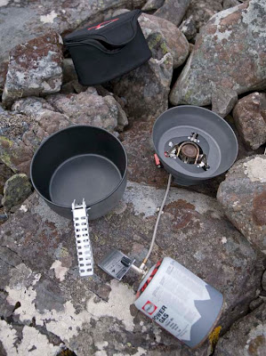
The Primus EtaPower EF integrated stove and pan.


Introduction
I first became interested in camping stoves with heat exchangers after a windy week in North Uist and Boreray in the Outer Hebrides. It was so windy and it took so long to heat anything that we ran out of gas. Fortunately we found where some peats had been left to dry. There were a few scraps of dry peat left, where the stacks had been built, to keep us going….

Then the JetBoil came along but as its name suggests, it is only really suited to boiling. The Primus EtaPower EF is the most recent development of this type of stove. Primus are a well established company with excellent after sales support. I still have, in working order, a 90 year old Primus half pint paraffin stove, which I inherited from my great uncle. I recently got spare lead and leather washers from Tiso.


Design
The Primus EtaPower is an extremely well thought out integrated design which is made from very high quality materials. It is a combination of a burner unit/base, windshield, pot, lid/frying pan handle, wiping cloth and insulated carry case. The whole thing packs into the cylindrical carry case which measures 22cm diameter by 12.5cm deep and weighs 850g. This means it will fit through the 24cm round hatch covers fitted on many sea kayaks.

Assembly
It is very easy to assemble. The burner unit including hose and piezo ignition can be detached from the base for transport but I usually leave it assembled. (Unless I decide to take a second 1l pot, which will fit inside the standard pot but it then is fiddlier to fit the burner/base combination inside the smaller pot without removing the burner from the base.) The base sits very low, directly on the ground because unlike other heat exchanger stoves which screw directly onto the gas cylinder, this stove has a hose which runs to the separate gas cylinder. This low position of the burner could burn an inflammable surface so you would need to be careful and not use the stove on a bothy table or dry grass. Once the windscreen is clipped to the base/burner unit, you can fold out three serrated pot supports. You can use the stove with bigger pots than that supplied but then you cannot use the windshield. Neither can you use the windshield for frying in the lid which doubles up as a frying pan.

The pot and lid
The 2.1l pot is made from hard anodised aluminium with a heat exchanger permanently fixed to the bottom. The internal diameter of the heat exchanger ring is 10cm so you could still use the EtaPower pot with other stoves in the unlikely event of a burner failure. The pot has a durable and effective non-stick coating. The pot handle looks pretty standard until you notice the little rubber pads inside the jaws which prevent scratching of the non stick coating! What attention to detail. The pot handle will not lift the tight fitting lid if you invert over the pot for boiling but the supplied cloth is big enough to use and stop burning your fingers. This is a further demonstration of the thought that has gone into the usability of this product. Only then will you discover you are still one step behind the designers! If you put the lid on the pot right way up, there is just enough bevel at its base to secure it inside the pot rim. In this position you can use the pot handle and you could keep a fried steak onions and mushrooms warm while you cook some other vegetables in the pot. If cooking something like porridge, you can boil it up then put the pot into the insulated carrying case, the case even has a dip on the side so that the handle fits in. You can then zip on the lid to let the porridge continue to cook for a few minutes saving more gas. When using this stove with the lid as a frying pan, you need to be careful not to turn the heat up full or you will warp the lid! However, this should not be a problem as the burner is so controllable.


If I am on my own I usually eat directly out of the pot to save dirtying a plate. I use a plastic spoon to avoid scraping the non stick coating. If you do this and hold the pot with the handle, you will find the heat exchanger now works in reverse and the wind will cool your meal very quickly. The solution is simple, put the pot in the insulated case. You can now enjoy your meal at a leisurely pace and it stays warm unlike your friends who are bolting their food off their plates before it get cold.

The burner and cylinder
The gas cylinder does not have a regulator like the MSR integrated stove but because it is on a long hose, you have several advantages. First is that the low height lends stability. Second, in a frosty morning you can turn the cylinder upside down to increase performance. Third, you can warm a little water in a separate pot then sit the gas cylinder in this to increase performance for the main cooking session. The piezo ignition works well except if it gets damp, when three separate examples of the stove failed to ignite, so matches or a lighter are still a good idea to carry. At full power the stove puts out 2kW of power which is pretty impressive but the flame is very controllable for simmering and so unlike a JetBoil you can use it for thick soups or stew. The wind shield and heat exchanger are so efficient that if you cup your hands round the pot with the burner fully on, you can hardly feel any heat.


Performance in the field compared with a conventional stove
This stove really works in a wind. I still got realistic boil times of just over 3 minutes per litre of water in breezy conditions when a JetBoil was seriously down on performance. Not only do you get short boil times, this stove is amazingly frugal with gas. So far I have used a single 450g cylinder pf Primus power gas which is a propane/isobutane/butane mix. I have used it for 10 nights’ camping for one person. Breakfasts were hot porridge and hot drink, lunches were hot drink and half the lunches had fried mackerel or sausage as well, evening meals were hot drink, hot soup and sachet of stew with quick cook rice or potato powder. I boiled or near boiled about 4l of water per day. I still have 1/3 of the cylinder or 150g left!!! In the past I have used nearly 900g of gas for 10 nights which is effectively two 450g cylinders. So in real camping conditions the Primus EtaPower stove is more than three times as efficient as my lightweight MSR Pocket Rocket stove used with a folding windshield and a hard anodised pot. In the future I will probably buy 220g or even 100g cylinders to use with the Primus to save weight and space despite the higher unit cost of gas. There is room inside the pot to store these smaller cylinders so the stove really is an all in one solution.

A question of weight!
Interestingly, the gross weight of the Primus EtaPower and 220g cylinder is 1180g and the gross weight of an MSR pocket rocket with MSR Duralite 1.5l pot (and lid which cannot be used as a frying pan) and folding aluminium windshield is 1410g. Despite being lighter 16% lighter, the Primus ETA Power combo with small cylinder will boil 50% more water in real conditions than the MSR combo with the larger cylinder! (Lightweight backpackers might stick with their Pocket Rockets for an overnight camp but for extended trips, the weight of the EtaPower is balanced by the extra weight of gas cylinders that a conventional stove requires.)

Other developments
Also available is the EtaPower Trail which comes with a lid intead of the frying pan, a smaller 1.7 l pot and nylon bag instead of the insulated case. Being lighter it may have more appeal for backpackers. The EtaPower MF is a multifuel version of the gas powered EF. It should extend the appeal of this stove to those who camp in winter conditions or high altitudes.

Conclusion
How do I rate the Primus EtaPower EF stove for camping from a sea kayak? Well, I have now bought one, so I must like it but I have also continued to use it and not gone back to my other stoves. Not only that, three people who I camp with have also bought one. It must score 12/10 then! Mind you, if Primus cannot supply spares in 90 years time, I (or my descendants!) would be prepared to reduce that to 11/10!

Wednesday, March 21, 2007

An Orange future for Barra and Vatersay but not for me.


This photo is of red haired, celtic cows on Bagh a Deas on Vatersay, the most southerly of the inhabited isles in the Outer Hebrides. It is especially for Michael, Hayden and Wenley and is one of a series of sea cow photos I am posting on this site.


On sea kayaking trips to the Outer Hebrides I usually take three PAYG SIM cards for O2, Vodaphone and Orange and I usually get mobile phone reception in most places but until now, not on Barra or Vatersay.

However, Orange recently started work constructing mobile phone masts on Bruernish and Bentangaval. It was hoped the network would be available from 09/03/2007. The mast at Bentangaval will also be used for the deployment of services provided by Connected Communities Broadband to create a wireless Internet network on the island.

The future might be Orange for Barra but not for Newton Mearns on the south of Glasgow. On 17/1/2007, as a result of local loop unbundling (LLU), Orange installed their own ADSL broadband equipment to replace equipment they had rented from BT. Since then my broadband has been just about unusable with download speeds of about 100 kbps (instead of the theoretical maximum of 6,500 kbps) and frequent drops of the connection. After much frustration, yesterday I requested my MAC code to transfer to another ISP. I will not be going to one of the free bundles with other services such as Sky satellite TV. I will be happy to pay for a decent reliable service.

Friday, January 05, 2007

A matter of maps and rutters.


The Nicolay rutter was the first accurate chart and pilot for the Scottish coastline. (The word rutter comes from the French routier.) It was unsurpassed for accuracy for several hundred years. Those of you who know the Solway might question the island off Burrow Head to the east of the Mull of Galloway.


It is of course the Isle of Whithorn. Despite its name this is no longer an isle, but it was when the map was drawn. Even in the 18th century, there was still a channel at high tide and a smugglers' boat escaped the Excise cutter by sailing into the harbour and escaping through the channel while the cutter blocked the harbour entrance.

The rutter was created following an anticlockwise voyage round Scotland by King James V in 1540. The original manuscript was made by Alexander Lyndsay. It was made into a printed version in 1583 by Nicolas de Nicolay, a French map-maker. The National Library of Scotland has placed a digital copy on their website which can be zoomed to allow examination in detail.Only a few copies of the map survive and the BBC news reported that one is due to be auctioned on January 10th. I love looking at old maps and have a fair collection having inherited many old linen backed Ordnance Survey maps of Scotland (some from Victorian times) from by Grandfather. As the rutter is expected to fetch in excess of £20,000, I have decided not to place a bid on this occasion.

In addition to many paper maps and nautical charts I also have digital Ordnance Survey maps at 1:50,000 from Anquet maps. I bought all the 1:50,000 maps in the north half of Britain for £100. These can be viewed on the computer or dowloaded to a PocketPC. Unfortunately they can not be loaded into my Garmin mapping GPS unit but tracks from the GPS can be downloaded onto the computer and waypoints created in Anquet can be uploaded to the GPS. However, it is great for trip planning to be able to scroll seamlessly round the coast. You can print the map at the original size on A4 paper or you can zoom out to cram more coast onto your A4 or zoom in to make the area covered smaller but easier to read for older paddlers who do not wish to wear their reading specs.


Sometimes I laminate two maps back to back, sometimes I just keep them in the excellent Ortlieb map case.


For the Garmin GPSmap76cs I have two Bluechart regions:2EU006R and 2EUoo4R. These cost about £120 each. They cover from Corsewall Point to Spurn Head. As you zoom in on these you get more detail appearing as the product includes both large scale and small scale charts. They show the coast line in reasonable detail but very little on land. They are useful for showing water depth which can be a predictor for such things as turbulence in tidal channels. They also allow you to calculate tide times for a large number of ports. This works both on the computer and the GPS. Both Bluechart regions fit comfortably within the 115MB memory of the GPS.


For the Garmin GPSmap76cs to show contours on land and also more detail between HW and LW than the Bluecharts, I bought the Garmin Topo map of Scotland England and Wales for £130. This is based on the ordnance survey but has less detail of woodland, buildings etc but it does show roads. You cannot print from it and on the computer the size of the detailed screen is restricted. On the GPS unit it is very clear and is good for locating skerries, beaches and burns. The maps are large files so you have space to load only those of the general area you are heading for into the GPS, the whole country will not fit.


With regard to online maps, I like to use Streetmap in this blog to show the location of photos. It allows me to enter a grid reference from a paper map or Anquet computer map. Pasting the location url into a link in the blog allows readers to open the streetmap page then zoom and scroll.

Another good online "map" is Google Earth. This can even import GPS tracks. Once I have the Google Earth window on the computer screen I save the screen to memory. (On a PC: SHIFT+Prt Scr)


Not all of Scotland has such good photos as this but for those areas with good coverage Google Earth can allow you to explore for campsites and can even show shallows.

It would appear that an advantage of being invaded by the USA is that Google Earth resolution dramatically increases. Ultimately, military use is what has driven the development of maps and also GPS. The British Ordnance Survey had its roots in the Jacobite Rebellion of 1745. In 1746, after the defeat of the Jacobites at Culloden, King George II of Great Britain commissioned William Roy to survey the Scottish Highlands for military purposes. Roy's name is engraved on the door of the Ordnance Survey headquarters in Southampton. Two centuries earlier, James V of Scotland commissioned his rutter to help quell the troublesome Lords of the Isles. The map was so strategic that it was obtained by the English who commissioned Nicolay to make printed copies; one of which was obtained by the French. They used it almost immediately to avenge the murder of Cardinal David Beaton of St Andrews who had been murdered during the Scottish Reformation.

What would Lindsay have made of Google Earth?

On 9/1/2008 Mark added:

"There is another way to get contour information onto a GPS without buying the TOPO maps. The necessary files, Contours v2, can be downloaded for free from the SMC website. You still need the Garmin software to get them on to the GPS itself but they are a big improvement on the Garmin base map.

It seems to work as a sort of overlay on the base map. This leads to some oddities such as sets of contours appearing where the base map shows sea but as the contours tend to be more accurate I have found that helpful as a kayaker!

They were put together by Dave Storey who must have spent a lot of time on it.

Not sure if I can post links here but I will try. The files are at http://www.smc.org.uk/ContourMaps.htm and there is a very helpful set of instructions at http://www.paulmac.force9.co.uk/geo/index.html.

Mark"

Thursday, November 30, 2006

Cuan Sound.


One of the most fun things to do in a sea kayak is to play in a nice tidal race. Between the islands of Seil and Luing lies the narrow Cuan Sound.


The flood tide is compressed as it travels up the great Sound of Jura and through Shuna Sound until it squirts out through the Cuan sound at up to 15km/hour.


As the tide turns the flow reverses and unlike the tide in more open waters it reaches maximum speed very shortly after turning.


In a recent post about wind farms Iona commented that tidal power is efficient and less intrusive. The Cuan Sound is one of the sites under consideration for a tidal barrage or fence to generate electricity.

We enjoy the Cuan Sound while it is still a free ride through!

Tuesday, November 28, 2006

Courses, bearings and GPSs


Most sea kayak navigation is done by identifying coastal features, checking on the map where you are in relation to them then paddling towards the one you want to get to. However, fog, night or tide might make things more difficult. I used to be a Luddite when it came to GPS units and it is fair to say that although I am a technophile, I was a late GPS adopter.


In this case I want to paddle to the channel to the south of Pabbay Beag from Stacanan Neideaclibh. The horizon is pretty featureless so I can take a grid bearing off the map, convert it to a magnetic bearing and the course is 89 degrees between the two points. I now paddle on a heading of 89 degrees and I should get there. But if there is a tide carrying me north from the course line, my bearing to my destination will change to say 92 degrees. I will have no way of knowing this unless I have calculated the speed and direction of the current before hand or if I have identified a more distant landmark behind my destination and the two move relative to one another (this is called using a transit). In this case there is no suitable transit landmarks.

This is where a GPS comes in. I set a waypoint in its memory for the place I want to get to by either; 1. entering a grid reference, 2. on a mapping GPS scrolling the pointer to the map position then pressing the MARK key or 3. if I was there earlier in the day, by pressing the MARK key when I was in the middle of the channel.

Next I press the FIND key and select the waypoint. The GPS then calculates the distance and course from your start location. Most GPS units have a GOTO page which displays a large arrow which points on a compass rose to the bearing from your current location to your destination. If you drift off course then the bearing changes. On simple GPS units the bearing pointer points to the top of the screen if you are on course. On more sophisticated units the bearing pointer will point to the destination if it is held flat. This is all pretty complicated to describe and in practice in rough water and if your eyesight is not very good, you will end up a long way off course before you detect the change in the bearing arrow.
In practice it is easier to monitor any change in the bearing as a number. On my Garmin GPSMap76cs I can set the bearing to the destination on a large type screen as a number. This is very easy to see especially for those elder paddlers whose close up vision is no longer what it was. If the tide carries me off course to the north, the bearing might Increase to 92 degrees. I now paddle more to the rIght and the bearing comes back to the course of 89 degrees. If I was carried off course to the south, the bearing might dEcrease to 86 degrees. I now paddle more to the lEft and the bearing comes back to the course of 89 degrees. In practice it is easy to keep within about one degree of the course on typical sea kayaking distances.

The GPS allows you to maintain a perfect ferry angle despite changing tidal flows. This is a function that map, compass, tide tables, chart and your brain would be unable to match. Off course it needs to be used sensibly. If you are crossing a channel and expect to be half way across at the turn of the tide, you may as well paddle straight across on a constant bearing and allow yourself to be carried down tide then up tide and these will cancel each other out and you will not waste time ferrying into the tide. Another point is that GPS units can be set to use various Norths such as grid and magnetic. I always set mine to magnetic so that if the GPS fails I can just switch straight back to the compass.

I explained all this to a friend who is very keen on skin on frame kayaks and Greenland paddles. He was rather dismissive of all this technology and wondered what was wrong with a good old compass. However, I am pretty sure the Inuit did not have compasses (not to mention aluminium frames and polymer skins).

PS in response to Cailean's reply.

In May I was fortunate enough to be part of a group that was led out to the Ecrehouse reef which lies 10 km off Jersey in the path of tidal currents that run up to 5 knots.


The leader was a very experienced local paddler who had been out to the reef countless times. He used local knowledge, his experience, compass, map, tide tables and tidal flow charts to take us out by the southerly route above. It was a safe crossing and allowed us to get carried down onto the Ecrehouse. If we had missed it we would have ended up going to England. However, we battled for 2 km more than we had to into a 3.5-5 knot current which was extremely tiring and a couple of paddlers in the group were very nearly exhausted by the crossing. The leader knew I had a GPS and asked how we were doing at the point we changed direction.

If we had done this crossing using the GPS then I would have set a waypoint about 1 km up tide of the Ecrehouse (at our final change of direction on the chart above) and we would have paddled straight to it.

I do think that being able to ferry at just the right angle using a GPS can conserve a groups' energy to leave a reserve for any unexpected tide or wind conditions they might meet later.
Here is a GPS track of a trip to Ghigha. On the way out it was flat calm and slack water. On the way back there was a 2 knot north flowing tide and a force 6 southerly wind. I used the GPS track not to navigate such a short crossing but to adjust the ferry angle. As you can see it was an efficient crossing in somewhat lively conditions!