Showing posts with label surf. Show all posts

Thursday, July 18, 2013

We had a swell time on Cara.

 We awoke to find an otter fishing in the bay where...

 ...we had camped for the night. After breakfast we broke camp and loaded the kayaks under a leaden sky. As we packed we were sorry to be leaving Cara after a most enjoyable two days.

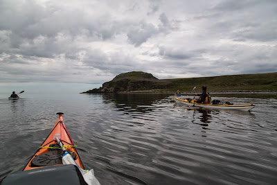
There was not a breath of wind as we paddled south along the east coast of Cara and bid our farewell to The Brownie who was no doubt observing our departure from his attic window in Cara House..

 We were bound for the Mull of Cara.

 Previous passages round the Mull have been rather lively affairs but...

 ...it was slack water and all was...

 ...calm apart from...
 ...the swell which...

 ...we met...
 ...as we rounded Cara's southerly point.

Tuesday, July 02, 2013

Kintyre ports not much good in a storm.

North of Machrihanish Bay, the coast of Kintyre has a rocky character. It was not easy to land due to the surf so we had a careful look at the several "ports" which are named on the map. "Port" usually signifies a traditional landing spot for a small boat.We passed Westport, Port nam Marbh, Port Corbert, Port na Croise and Port Crom but each faced west and was full of breaking surf. Historically this must have been an important coast as in addition to the ports, we passed six duns and forts and there were more further north.

We finally found a small inlet which was protected from the surf by offshore reefs at Killocraw.

 It was a great relief to finally stretch our legs while admiring the distant...

...hills of the Mull of Kintyre, round which we had paddled 65 km since the previous evening.

Sunday, June 30, 2013

Surf's up but coal's run out at Machrihanish Bay.

 From  Machrihanish village we paddled north...

 ...over a glassy sea and soon...

 ...the misty mountains and tides of the Mull of Kintyre were left far in our wakes.

Beyond the surf zone (we chose not to land) the magnificent beach and sand dunes of Machrihanish Bay...

 ... stretch uninterrupted for 7 kilometers. It is hard to believe that four and a half centuries of coal mining took place here and ended as recently as 1967. The dunes also conceal the longest runway in Britain.

At Westport at the north end of the bay the surfers were enjoying *** conditions. We waved as we passed and it turned out Jennifer knew the surfer on the left.

Tuesday, April 23, 2013

"Breaks", "breaks heavily" and "breaks very heavily" on the west coast of Muck.

Although it was only the first of March, Fulmars were already pairing up for the breeding season on the NE cliffs of Eilean nan Each (Horse Isle) which lies off the north west coast of Muck. The calm seas and almost complete lack of wind could easily have lulled us into a false sense of security but I had in mind the Magicseaweed surf forecast for nearby Tiree...2.5m SW!

 Whoohoo we had just turned the north end of Eilean nan Each when the swell hit us. Fortunately...

 ...it passed under us and it was actually the rocks it hit! Spray was thrown high in the air and we felt a near continuous rumbling in our chests.

We needed to wait a while before we entered the gap between Eagamol and Eilean nan Each as the bigger sets surged through with some degree of vigour.

However, patience was rewarded and soon we were in the sheltered lee of Eagamol.

We now came to the exposed west coast of Muck.

We were glad there was no wind as the chart warns of...

"Breaks"

"Breaks Heavily"

and "Breaks Very Heavily". We felt very lucky to experience the pounding surf in such a remote place but in such benign conditions. Even, so neither of us suggested putting in a little rescue practice.

There now followed a gap with no photography as the many basalt dykes that radiate out from Muck threw up many unexpected boomers. But once we approached the SW corner of Muck the swell seemed to die as the north going tide  increased.

We now enjoyed a distant view of Coll and looking back, we could see...

.... the outline of Rum through the gap between Eagamol and Eilean nan Each. Eigg, where we had spent the previous night, rose high above the low lying northern rocks of Muck.

Monday, April 08, 2013

We did not want to spend Easter on Eigg.

Ian and I had enjoyed an excellent luncheon on Camas Sgiotaig at the NW corner of Eigg but it was now time to paddle the remote west and SW coasts of this lovely isle. In the winter this surf beach has dangerous surf breaking for weeks on end. We were keen to move on as we did not want to spend Easter on Eigg. Fortunately a wait was rewarded with a relatively calm spell and we both launched safely.

Although the sun threatened to break through...

...the fog lowered again and we could only see the lower reaches of Eigg. Of the classic view NW to Rum and her Cuillin mountains there was not a trace.

As we paddled across the Bay of Laig, we caught sight of Lageorna, where we had arranged to stay the night.

As we continued the wind dropped to nothing...

...and the only sound was...

...the rumble of the surf breaking...

...along the base of the cliffs.

The rock architecture on this coast of Eigg is superb...

...and the fog added to the atmospheric conditions by...

...lifting like a veil; revealing the splendor bit...

...by bit.

The basalt and pitchstone upper rocks sit on a bed...


 ...of more ancient sedimentary rocks. Fossilised tropical trees have been found below the edges of this volcanic layer.


We had hoped to see the iconic pitchstone ridge of the Sgurr of Eigg but it remained hidden by the mist.

Our main concern during this change of plan was that we would meet an adverse tide in the Sound of Eigg.

However, despite it being springs, we met no tidal current whatsoever and soon arrived at the old pier of Glamisdale. As we pulled our kayaks up the jetty we thought we were alone but two youngsters ran down out of the mist. "Are you the Canoe Boys?" "Sue says she is just shutting the shop but she will wait till you get ready and run you up to the B&B!"