Showing posts with label industry. Show all posts

Wednesday, November 18, 2015

Gunfire, a lost Queen and a wreck in Kirkcudbright Bay.

As we made our way back to the beach at the north of Little Ross Island we could hear the sounds of guns of various calibres coming across the water. They were being fired at Dundrennan Firing Range (or Kirkcudbright Training Centre as it is now called). I had called the Range Officer on 07786 126151 (manned 24 hrs) prior to our departure so I knew the range would be closed and it would not be possible to continue east round the coast. The Range Safety boat, the Gallovidian III, was already moored off the north point of the island. From previous experience I knew that her skipper Gary McKie would up anchor and motor close inshore as soon as he saw us. So Ian called him up on Channel 16 to let him know our intended route, which was well away from the range.

After a cheery wave from the Gallovidian III we set off against a stiff wind up the west side of Kirkcudbright Bay.

Little Ross slipped astern as the flood spring tide assisted us against the wind.

Once clear of the range, we crossed the bay to the wooded shores of St Mary's Isle. An Augustinian priory was established here in the 12th century. Mary Queen of Scots stayed at the priory in 1563 while enroute to Dumfries from Kenmuir Castle near New Galloway. Legend has it that her party was benighted as they approached Kirkcudbright. Her escort was disinclined to risk her safety in the town's inns so they made their way here. In 1568 Mary came this way again after her defeat at the Battle of Langside near Glasgow. She spent her last night in Scotland at nearby Dundrennan Abbey before fleeing to England by boat from Port Mary and capture by Elizabeth I of England.

The lee of St Mary's Isle was a great place to catch our breath.

Further up Kirkcudbright Bay near Gibbhill Point we came across the wreck of this old wooden trawler. It had seen better days.

Monday, November 09, 2015

Buzzing walls and more follies at Castle Haven.

 From the beach at Barlocco we continued SE towards Kirkandrews where...

...we were passed by two small shellfish boats. This one is "Irene K" A3 and her home port is Campbeltown. They had both been launched from road trailers near Kirkandrews. They seemed a long way from home.

On the way we passed Corseyard farm with its tower and model dairy. The tower is not an old castle, it is actually a water tower and the dairy is a veritable "coo palace". The farm was built by Mr Brown of Knockbrex who had retired there from the Manchester department store of Affleck and Brown.

 The light, clouds, wind and tide were Solway paddling at its best but yet again...

 ...we made a diversion, this time into Castlehaven Bay.

At the back of the bay lies the ruins of Castle Haven which was built during the Iron Age on a rocky promontory. It is thought that over 1000 years after it was built, the Vikings refortified the site as a "borg", giving rise to the name of the local hamlet of Borgue.

 We decided to land and explore further.

 We entered via the postern gate which leads down to the sea.

Castle Haven was excavated by Mr Brown of Knockbrex and James Barbour F.S.A.Sco in 1905 and they demonstrated that it had a galleried wall structure as is shown...

...in this plan which was made at the time and published in the Journal of the Society of Antiquaries of Scotland in 1907.

After the excavations were finished Mr Brown rebuilt some of the dry stone walls by adding height onto the existing foundations.

The doubled wall structure clearly seen in this photo is very typical of the brochs and duns found in the highlands and islands of Scotland. This makes Castle Haven the most southerly broch in Scotland. Most duns are circular but Castle Haven is D shaped as its sea edge follows the line of the vertically raised rock strata at the edge of the bay.

We were not alone. The air was full of the sound of buzzing bees who were gathering nectar from the climbing plants that were gradually choking the walls of Castle Haven.

Read more on Ian's blog here.

Friday, November 06, 2015

Setting off with a fair wind and tide on the Solway Firth.

The day dawned fair on Fleet Bay in the Solway Firth and as the line of clouds drew back to the SE we enjoyed some warm October sunshine.

Ian, Mike and I soon had our kayaks packed and at the water's edge. It had been our intention to paddle east to Sandyhills stopping at Little Ross Island and Hestan Island on the way. Unfortunately the firing range at Dundrennan was in use so we would not be able to pass. So we intended to do a there and back paddle as far as Kirkcudbright.

 It was a most marvellous start with a fresh tailwind and paddling...

 ...straight into the sun.

 The ebb tide was also with us and it seemed like no time at all until...

 ...we landed on Ardwall Isle for first luncheon.

We decided to climb to the top by way of the farm track which leads up from the beach. The farmer drives over from the mainland at low tide several times a year to cut the grass and bale it.


As we gained height we enjoyed a great view over the recently cut meadow to Murray's Isles Ravenshall Point and to Wigtown on the far side of Wigtown bay.

 There were plenty of brambles but almost no sloes.

From the summit we had a clear view back across Fleet Bay to where we had come from, the cluster of caravans under Ben John.

 The simple cairn at the summit of Ardwall Isle overlooks the grand...

 ...house at Knockbrex with its fields extending down to a little harbour.

Beyond Barlocco reef our way lay away to the SE, beyond distant Ringdoo Point.

For the full kayak stereovision experience follow Ian's blog which starts here.

Monday, October 26, 2015

A series of coincidences on our leaving Cara and Gigha.

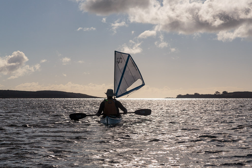
 We enjoyed a leisurely first luncheon on the white shell sands of Port Sgiathain on the south west coast of Gigha. (Perhaps it was only second breakfast because I cannot recall if any essence of Jura was consumed.) We were in no hurry as we wished to use the ferry slipway at Tayinloan to recover our kayaks. Having no desire to inconvenience the ferry or experience the unleashing of its ramp we planned our our crossing so that it would coincide withe the ferry's departure from Tayinloan. This meant that it would overtake us on our crossing of the Sound of Gigha so we kept a sharp lookout behind.

The rumble of engines soon announced the passage of the MV Loch Ranza but we were well to the south of her course. For the first time Ian caught a clear sight of the Paps of Jura and I regailed him of the trip Tony and I had made to Jura back in April. So that's another future trip sorted!

 Gradually Gigha, the Paps of Jura and...

...Cara with its white sands, Mull and Brownie slipped astern as we approached...


 ...Tayinloan on the Kintyre side of the Sound.

 We had only the briefest of stops, while the ferry finished loading, during which we had time to admire...

 ...the creel boat Kyra OB469 before...

 ...the Loch Ranza departed with another cheery wave from her captain.

 As the ferry motored her way back to Gigha...

 Ian and I landed on the slipway and strolled back to the cars for our kayak trolleys. It had been a truly laid back and delightful trip and we savoured our last moments on the west coast of Kintyre. We were in no particular hurry and decided to enjoy the delights of Jessie's Ferry Farm Tearoom before heading on our way. Coincidentally Ian and I both chose the daily special, wild boar with chorizo burgers which were literally immensely satisfying! Ian and I now faced equally long drives to diametrically opposite parts of Scotland. Ian to Grampian in the NE and myself to Galloway in the SW. Amazingly we each arrived safely within 10 minute of each other. What a coincidence! But this was not the only coincidence on this trip. I had set my iPod onto shuffle play and remarkably the second song which came on as I was driving north on Kintyre towards West Loch Tarvert was by Paul McCartney and Wings. No it wasn't Mull of Kintyre, with its mist rolling in from the sea (of which we had seen plenty). It was Helen Wheels, which recounts one of the McCartney family trips from their farm on Kintyre to London in their trusty LandRover which they called "Helen Wheels". I am pretty sure that the Brownie of Cara would not know how to hack an iPod shuffle play order....or would he?


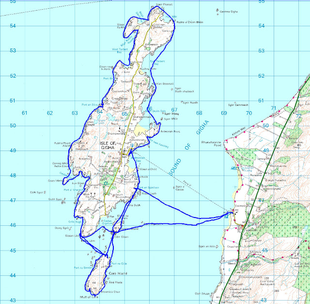
Altogether we had enjoyed two half days and one full day paddling 51km round Gigha and Cara. It was probably about my 10th sea kayaking trip but Ian's first. Like me, he plans to return but I do not think that is a chance coincidence!

Thursday, October 22, 2015

The log boat from Gigalum made its way slowly through the skerries.

 The SW coast of Gigha is a delight, offshore skerries and shallow waters with...

 ...a sandy and weed covered bottom create a marvellous environment to journey through.

Ian could not resist landing on a reef to get a little more height for getting photographs of the sea bed. Unfortunately there was still no sign of the sun which would have made his photographs zing!

 As we paddled south, back towards our temporary base on Cara...

 ...there was just a hint in the west that the sun might break through but...

 ...the gap in the clouds was only fleeting. Then...

 ...low grey clouds gathered in as both kayakers and the fishermen on OB595 (Blue Angel from Tarbert) were making their respective ways home. The Gigha community windmills were rotating steadily in a chilling NW breeze. We were glad that yesterday's T shits had been replaced by thermals and dry suits. Once on shore we knew it was going to be a cold night unless we could find some more firewood.

After leaving Gigha we had one further delight. With the haunting calls of curlews, the pip, pip, pipping of oystercatchers and the raucous croaking of a couple of squabbling herons ringing in our ears, we had yet another chance to paddle through the skerries at the...

...south end of Gigalum Island. I even managed to find...

...some decent bits of firewood within the rocky recesses of the skerries.

 From Gigalum Island the white shell sand beach below our camp was now just a kilometer away across the Sound of Cara. We landed just before 6pm. We had only covered 30.4km since leaving that morning but the circumnavigation of Gigha had proved to be full of interest. Although we may not have had the sun, we had enjoyed light winds and only the slightest of swells. This meant we had been able to explore some nooks and crannies on the exposed west coast that would have been all but impossible at most times of the year, never mind in October when the West coast of Scotland is normally blasted by equinoctial gales sweeping in from the Atlantic. On landing again on the shore of Cara, we did not forget to greet the Brownie in the proper and appropriate manner. On Cara one must take nothing for granted...