Showing posts with label geology. Show all posts

Thursday, May 19, 2016

Raising expectations of the stunning raised beaches of West Loch Tarbert, Jura

We paddled on round the west coast of Jura leaving the Sound of Islay behind and entering West Loch Tarbert which nearly bisects the island.

On our way we passed many more basalt dykes which ran down the hillside into the sea. This one looked like Chief Running Deer of Jura complete with war bonnet.

 At this turquoise lagoon the waters were...

 ...crystal clear and we stopped on its...

 ...sands below...
 ...an incredible raised beach which soared up towards the slopes of Beinn an Oir. We had spotted some well seasoned driftwood which had been cast high above the high watermark.

We gathered arm fulls before returning to the boats. We were bound for Cruib Lodge at the head of West Loch Tarbert and we knew there would be little wood there.

The view of the Paps of Jura gradually changed as we entered  West Loch Tarbert and started paddling east.

 Ben More on Mull rose above the Ruantallain peninsula on the north side of the loch as Hazel Ann CN373, a creel boat from Port Askaig motored out of the loch.

 Glen Batrick, a gap in the hills behind the south shore opened up a view of the Paps of Jura again.

 At the mouth of the glen lies Glenbatrick house.  It is locally pronounced Glenabatrick after the original name Glenabedrig. It belongs to Viscount Astor who is David Cameron's stepfather in law. The Camerons have spent several holiday's here, far from the pressures of Westminster.

 From Glenbatrick we paddle sailed east up the outer loch in an...

 ...increasing NW wind. The combination of wind...

 ...sun and spray made for some incredible paddle sailing conditions but we took a break from the fun at...

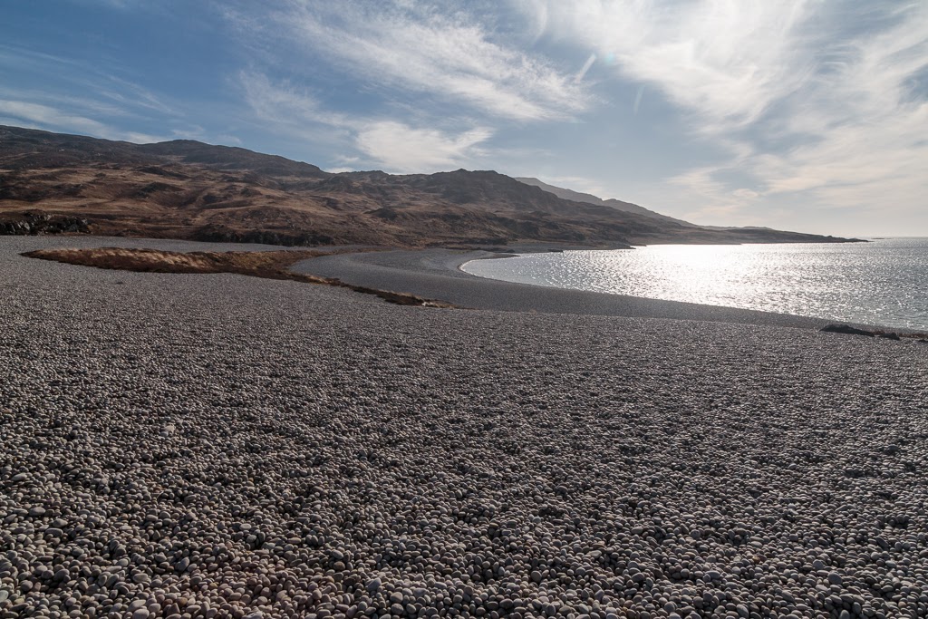
 ...Rubha nam Meann (headland of the young goat) to explore one of the most intriguing locations on the British coastline.

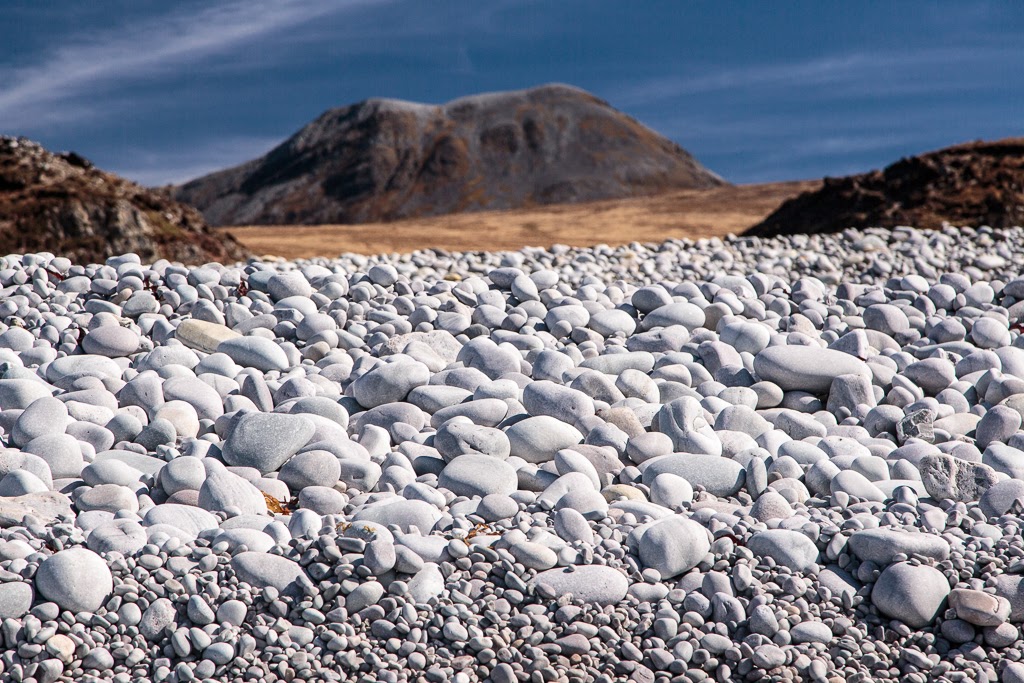
The cobbles on this beach rise high above the current HW mark and it is one of the best examples of a raised beach in Britain. I have been here many times before but it was Ian and Mike's first visit. As I had raised their expectations and built the place up, I hoped they would not be disappointed.

As you climb towards the summit...

 ...of the beach you are stepping back in time until you reach the...

 ...summit of the beach where the tide last went out some 10,000 years ago.

It is like a time machine because despite the passage of the millennia, the cobbles are as clean as if the tide had just receded that morning. Since the great weight of ice over the land melted, this part of the Earth's crust under Scotland has been steadily rising from the magma below.

There are so many cobbles here that they have created a dam across the glen behind which retains a fresh water loch, Lochan Maol an t-Sornaich, (lochan of the rounded hill of the boulders). No river flows from the loch. Its waters seep gently to the sea through the spaces between the cobbles.

 Near the summit of the beach the largest cobbles are to be found and on some of the oldest specimins ancient colonies of lichen have formed.

There are only a few patches of vegetation that have become established on the beach and when...

...seen from above (photo by me September 2009) they are situated most harmoniously within the landscape showing that Slartibartfast had a good understanding of the principles of Feng Shui. Indeed he was probably the founder of this ancient art which symbolises the harmony between wind and water. 

 Each of us wandered with our own thoughts in the vastness of this quintessential Jura landscape...

...we realised how privileged we were to be able to visit this special place that few of our countrymen are even aware of.  The "paths" across the cobbles were not made by  the feet of men but are where countless generations of deer have picked their way carefully across the beach.

Reluctantly we left this special place where time has stood still.

Wednesday, May 04, 2016

No room in the bothy and things that might have been...

 At the north end of the Sound of Islay the Ruvall lighthouse stands tall. It was built high so that it could also be seen from the south end of the Sound of Islay (see below). As we were discussing the lighthouse we noticed that the tide had turned in the Sound and it was now time to hitch a ride south.

The Jura coast line continued to amaze. At Alt Bun an Eas (burn with the waterfall at its foot) a deep V gorge has been cut through a raised sea cliff. the gorge is too big to have been cut by the current burn and dates from the days after the Ice Age when a huge torrent of meltwater made its way to the sea and the land rose as the weight of the ice sheet diminished.  The gorge has a series of waterfalls and infinity pools just above the beach.

Tony and I climbed up to these pools on a previous visit and Ian and I noted the possibility of a refreshing shower here the next day.

I never tire of this coastline and have paddled it 10 times now. This might not seem that much but considering how hard it is to get here from Glasgow it is a lot!

 At first the tide carried us gently down the Sound but the spring rate is 5 knots and...

 ...soon we were fair zipping along.

 The bottom of the Sound of Islay is very clean so despite the speed of the current, there are no overfalls and it only becomes rough if the tide is against the wind (as we would experience the following day!)

Although the water was like a millpond we passed the lighthouse at Carragh an t-Sruith (pillar of the current) at a casual 15km/hr!

We hit 16.4km/hr in the narrows between Feolin and Port Askaig where the Jura ferry MV Eilean Dhiura crosses. our destination was An Cladach bothy, which lies beneath the highest summit to the right of the ferry.

South of the narrows there were some great eddies which carried us off course but soon we arrived at...

...An Cladach bothy on the SE Islay shore (where Tony and I had stayed exactly a year ago). Unfortunately it was occupied by two couples and there are only 4 bunks. When we went inside the first woman said "Oh look they are all wet!" The second said "Oh look they are all wearing the same". It was then that I noticed the row of shiny polished boots by the door and a huge supply of food and drink including enough uncrushed loaves for a week. We decided to move on. One of the men followed us out and rather apologetically said he was the Mountain Bothy Association maintenance officer and they were up for a week to maintain the bothy.

Whatever the purpose of their visit, we saw no work clothes or maintenance materials. They had obviously been dropped off by boat rather than making their own way in. Parties using bothies for long term holidays seem to be becoming more common. When Ian and I visited Rum in the winter the warden warned us of two undesirables with bows and arrows who had set up residence in Guirdil bothy for two weeks. Exactly a year previously Tony and I had come across some Glaswegians in Cruib Lodge in Jura when we arrived after sunset. They told us they had been there for 10 days. Fortunately because it was outwith deer shooting season the estate side of the lodge was unlocked and they were in there. So we were able to stay in the MBA side. Another sea kayaking friend came across a man and two alsatian dogs who had been in a non MBA bothy in the Sound of Arisaig for 3 weeks! Whatever, I would only stay a night or two in a bothy as long term residence effectively decreases the number of people who  can take shelter there.

The sun had just set on the shore so we paddled down the rocky coast looking for somewhere to land and set up camp before dark. Mike and I landed in a little rocky inlet and were just about to explore when our VHF radios burst into life. It was the ferry MV Finlaggan warning the "warship in the Sound of Islay" to keep clear while she berthed at Port Askaig.

 The warship very politely assured Finlaggan that there would be no obstruction to berthing.

 The warship proved to be a Royal Navy type 23 frigate, HMS Iron Duke, which was also involved in Joint Warrior. This was her on her way south after live firing exercises at Cape Wrath in which she used her 4.5" front mounted gun. Unfortunately the wash of both vessels trapped Mike and I in the gully for some time and the sun...

 ...had well set before we were able to launch and found somewhere more suitable to set up camp. If you enlarge this photo, you will just see the light from Ruvaal lighthouse 17km away to the NNW up the Sound of Islay. The photo also shows what would have been a glorious sunset when viewed from the little cove between the dykes of Jura, where we had last stopped and were tempted to camp.

 It does not pay to think of what might have been, either golden sunsets or warm bothy fires, instead we concentrated on getting the loaded boats up the beach and setting up...

 ...the tents in the light of the gloaming and a full moon.

Not only had we brought tents we had also brought wood and a bag of charcoal, we soon had a warming fire going. What might have been a very uncomfortable night passed in great comfort, no doubt helped by some generous snifters of malt whisky. Another disaster was realized when I realized I had left the flask of Islay malt (Caol Isla) in the car. Fortunately reserve supplies of Jura and Speyside malts were available!

Tuesday, May 03, 2016

Rendezvous with a swarm of oxymoronic priapic dykes on the SW coast of Jura

Leaving the mouth of West Loch Tarbert we made our way along the SW shore of Jura towards the northern entrance of the Sound of Islay.

No sooner had we entered the Sound, which is guarded by the Ruvaal Lighthouse on its Islay shore, than this otter popped up right by Mike's bow, what a treat.

As we travelled over the turquoise and ultramarine water of the Sound, the Paps of Jura increasingly...

 ...dominated the landscape, heaving high into the sky above a sea cliff which was now high above the current sea level. Unseen in this photo, there are raised beaches of cobbles above these old cliffs. The land and seascape of Jura is unique, even in a country of such varied geology as Scotland.

The cliffs are broken by a swarm of dykes that march down the hillsides and down into the waters of the Sound.

This particularly fine priapic (if that is not an oxymoron when discussing a dyke) specimen is a potent landmark which can be found to the WNW of Loch na Sgrioba (loch of the furrow).

Jura really is a stunning place to paddle but it was now 14km since we had had a decent stop so we took a break...

...on a little cobbled beach that nestled within a swarm of dykes. We took our second luncheon with our backs to a sun warmed basalt dyke which sheltered us from a cold north wind. We toasted ourselves with a further snifter of Jura Superstion. We had plenty of time as the tide was still running north.

We attempted a little coastal exploration while waiting for the tide to turn.

We managed to get through some arches and ...

...scrambled up some ledges but turned back above these dykes as we were on steep sloping grass that ended above some cliffs.

From our vantage point we spotted a French mine warfare vessel, possibly M642 FS Cassiopée. She was taking part in the Joint Warrior NATO exercise.

Back at the beach, the tide had turned, it was time to set off on the last leg of our journey...