Showing posts with label Sound of Mull. Show all posts

Tuesday, May 19, 2009

Rounding Ardnamurchan Point at sunset


If we had set off to round Ardnamurchan from Paradise Beach, we would have hit Ardnamurchan Point with a force 4 north wind against the peak flow of a north going spring tide. It would not have been particularly pleasant for Phil. By taking time out for an evening meal in Laorin Bay, the wind had dropped to force three and I reckoned that we would hit Ardnamurchan about 30 minutes after the tide had to to flow south again.

We decided to go for it and avoid that 7km walk from Kilchoan over to where we had left the car on the north of the peninsula! We set off for Ardnamurchan Point, 11km due north across the Sound of Mull.
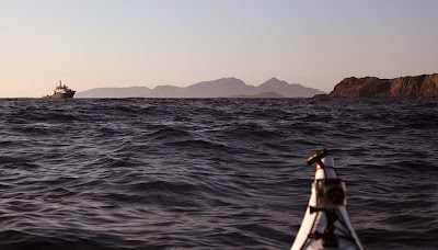

On the way across the Sound of Mull, we spotted a familiar outline approaching. It was the Pharos, the Northern Lighthouse Board maintenance vessel.
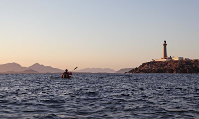

We approached Ardnamurchan as the sun was setting. Muck, Rum, Skye and Eigg lay beyond the point.


Huge swells were coming in towards the point and the sun sank below the "horizon" several times before it finally disappeared. It was an incredible experience to be off the most westerly point of Britain at sunset.

Despite the favourable conditions, it proved to be quite lively round the point, particularly on its north side.

There is now a 20 minute gap in the photographs!

10/05/2009

Thursday, May 14, 2009

Ardnamurchan to Mull


About 1km to the south of Ardnamurchan we came to the black basalt rocks of the headland of Corrachadh Mor. This is actually the most westerly point of Britain, not Ardnamurchan. However it is possible to drive a car to Ardnamurchan so this lesser point receives the vox pop laudit of being the most westerly point.


Working round the coast of the peninsula we came to the little isle of Eilean nan Seachd Seisrichean at the mouth of the Sound of Mull. The MV Lord of the Isles can be seen entering the Sound on her voyage from Barra to Oban.


We now struck out across the Sound of Mull aiming to land on Mull some 8km distant.


We enjoyed a great crossing with a fair tide, a following wind and helpful swell.


We landed just to the SW of Quinish Point on Mull.


Ardnamurchan lighthouse seemed a very great distance away.

10/05/2009

Sunday, January 11, 2009

Achadun Castle, Lismore


We were soon powering up Loch Linnhe and leaving the Sound of Mull in our wakes. We decided to cut another kilometer off our trip by cutting inside the tidal island of Bernera. If the tide was not sufficiently high then it would just mean another stop to watch it rise!


The inside passage also allowed a closer look at Achadun Castle on the SW of Lismore. This was built by the MacDougalls at the end of the 13th century. It passed to the Bishops of Argyll but was abandoned by them about the middle of the 15th century. It seems to have been disused since then.

27/12/2008

Saturday, January 10, 2009

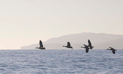
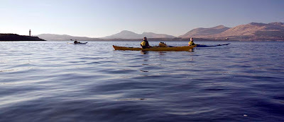
Five Canada geese, four sleek kayaks, three lofty mountains, two light houses and a ..... Fiart!


After a calorific luncheon of Christmas cake we reluctantly left Eilean nan Gamhna and we were soon heading south towards the Sound of Mull. A skein of Canada geese flew overhead with whooshing wing beats. Our progress was not so rapid and it was obvious we would be returning in darkness again.


In the distance the MV Isle of Mull ferry entered the Sound of Mull on her way to Craignure between the Lady's Rock lighthouse and the the Eilean Musdile lighthouse. In the distance, the mountains of Mull soared up from the Sound.


As we were running out of time, we decided to cut through the narrow channel to the north of the lighthouse by Rubha Fiart. This would save 1.8km and after our recent trip round the Mull of Galloway, neither Tony nor I felt we had anything to prove.


As we entered the narrow channel at the south of Lismore, the tide had already turned. It was now flooding strongly and carried us westward towards distant Duart Castle on the south shore of the Sound of Mull.


We were now leaving the Lynn of Lorn and were soon expelled into the waters where the Sound of Mull joins the mouth of Loch Linnhe.


Feeling rather bloated after all this exertion, we drifted in the tide for a while...


... before digging our blades into the glassy waters on the way to our next stop on the tidal island of Bernera.

27/12/2008

Thursday, February 22, 2007

Mackerel sky.


"Mackerel sky, mackerel sky - never long wet, never long dry. "

Is there any truth in this piece of folklore?

A mackerel sky is composed of patches of altocumulus cloud. It represents a layer of unstable and humid air which often follows a ridge of high pressure and precedes a warm front by about 400km. As warm fronts move about 50km/hr you can expect a change in the weather in about 8 hours. This was taken at 11am on our trip from Loch Sunart to Mull on 18/2/07. The wind picked up to force four from the SE by 12:00. By 14:00 the wind had increased to force 5 and it clouded over by 14:30. It was raining by 23:00.

On Saturday 17th February, when we were planning our trip, Scotland was under a ridge of high pressure and there was no wind. Sunday 18th dawned clear and still but the BBC forecast for Tobermory and Mull was for 17mph SE winds. The met office inshore forecast issued at 0600 UTC on Sunday 18 February 2007 for Mull of Kintyre to Ardnamurchan was:

Wind southeasterly 5 or 6, occasionally 7.
Precipitation: rain then showers.
Visibility: moderate or good.
Sea state: Moderate occasionally rough.

Although apparently sheltered, the Sound of Mull can be very rough especially in wind against tide conditions. LW Oban was at 12:35, 1 day before springs. Streams in the Sound of Mull change at HW and LW Oban. The flood flows to the NW and the ebb to the SE. When we crossed the Sound we had force 4 SE wind against the last hour of the ebb and it was rough in the middle. Although the wind was forecast to increase later, we enjoyed our stop at Tobermory as I knew that by that time the flood would have started and being with the wind, it would flatten the water. This is exactly what happened.


The white horses disappeared and the water flattened as the flood built up speed. We had a trouble free paddle back to the shelter of Loch Sunart.

Wednesday, February 21, 2007

Decapitation at Camas nan Liath!


On our recent paddle in Loch Sunart and the Sound of Mull we enjoyed an idyllic stop at Camas nan Liath. From a distance the cobbles on the beach looked grey and I thought that was the explanation of the Gaelic name which I took to be "beach of the grey" though I though just Camas Liath would have done.


The water was crystal clear and beckoned us in to the beach which, nestled under the steep wooded slopes of Tor nan Con. Even in winter, the colour of the birch and aspen branches contrasted with the grey of the cobbles and invited a return in spring.


To the north west, the beach is exposed to the full force of Atlantic storms and the bed rock had been worn into mounds, hollows and channels by the action of countless wave tossed cobbles.


In the deeper hollows, at the bottom of each crystal clear pool of water, there was a mixture of cobbles and pebbles of different sizes and rock types.


As we left, we paddled past great grey "heads" of rock whose necks had been worn away by the wave action. Some of the older heads had been decapitated and fallen as boulders. Suddenly, the full and subtle meaning of the Gaelic "Camus nan Liath" hit me: Beach of the Grey Heads.

What a place, what a language.

Tuesday, February 20, 2007

Mishnish mission via Morven to Mull from Ard na Murchan


We started in the shelter of Port na Croisg, Loch Sunart with the grentle hills of Morven receeding in the distance.


Our route was 28km. Coming back over the Sound of Mull the tide was strongest towards the Morven shore.


Tobermory was founded in 1788 by the British Fisheries Society to service the herring fleet. It is named after tobar Mhoire or Mary's well. In 1588 the Almirante di Florencia, a galleon of the Spanish Armada blew up in the bay. She was reputedto be carrying thirty million gold ducats.


At low tide the beach is sand and shingle. At high tide there are a couple of slipways. There is a small one conveniently situated beside a blue fish and chip kiosk at the pier in the middle of the bay (beside the distant red house in the upper photo.

Friday, December 22, 2006

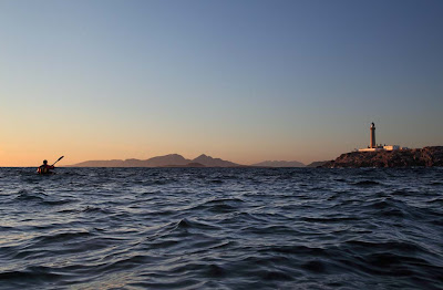
Eilean Musdile lighthouse


I thought a midsummer sunset behind a lighthouse might brighten a short dark winter day. This is Eilean Musdile light which is at the south end of Lismore and guards the entrance to the Sound of Mull from The Firth of Lorn. Roberst Stevenson built the lightghouse in 1833. It weas automated in 1965. It flashes white for 0.5 seconds every 10 seconds.


It was taken from MV Dundarg, a 1930's fishing boat which was chartered by Andy Spink of Hebridean Pursuits for their Wild West Week, sea kayaking off the west coast of Scotland.


The week lived up to expectations!