Showing posts with label Mull. Show all posts

Friday, January 31, 2014

Gusty headwinds under the cliffs of Mull's Laggan Peninsula.

 We awoke on the shores of  Loch Buie on Mull to find that a light SE wind was sufficient to keep....

 ... the morning midges at bay. The weather forecast was for light and variable winds increasing to F4 to F5 S-SE winds by midday. Given that it was midsummer and sunny there was also the possibility of afternoon thermal winds increasing the wind even more. So we decided to make an early start and were on the water by 07:30.

We were in the lee of the Laggan peninsula and at first there was very little wind but a fair amount of swell was wrapping round Rubha na Faoilinn at the entrance to Loch Buie.

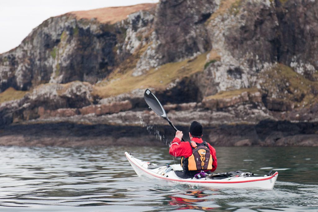
On rounding the point we were hit by a very gusty head wind from the SE which...

...was shrieking and swirling along the steep cliffs below...

...the steep cliffs of An Garradh. The gusts were so strong that they were lifting waterspouts off the surface of the sea and threatened to snatch the paddles out of our hands. As we put our heads down, our forward progress was slowed to less than 1km/hr.

The early morning sun was reflecting on the sea in front of us, which made it difficult to see the approaching gusts. The gusts were so unpredictable and ferocious that I did not risk using my Canon DSLR and so these photos were all taken with a little 2mp waterproof camera.

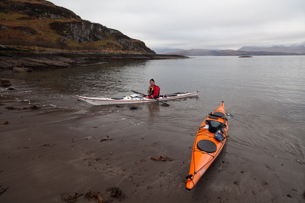
After an exhausting 4km paddle straight into the teeth of the wind, it was a relief to shelter in the lee of Frank Lockwood's Island. We were rewarded by a magnificent view of the cliffs on Mull's remote Laggan peninsula, which stretched away to the NE. Lying in the shelter of the little island we discussed our options. We wondered if the forecast F4-F5 winds had arrived early. If so they would make our 12 km open crossing of the Firth of Lorn rather unpleasant as they would be blowing over and against a big spring ebb tide. We battened down the hatches.... .

Thursday, January 30, 2014

Caught between the tide, a rock and a hard place in Loch Buie.

The midges round Loch Buie on Mull can be ferocious so Jennifer and I set up our cooking on rocks well down the beach to get away from them. Unfortunately it was a really high spring tide and our rocks gradually disappeared...

...leaving just a few stones above water ( above left of the bonfire). So we joined Phil and many millions of midges at the top of the beach where we lit a driftwood fire.

We had hoped for a magnificent sunset behind Beinn na Croise 503m but an approaching cold front brought too much low cloud.

Every cloud has a silver lining and this one brought wind. This quickly got rid of the midges but it was impossible to sit in one place and avoid the acrid woodsmoke as...

 ...the wind swirled round the shores of Loch Buie.

At last we were free of midges and the wind settled. We reminisced about past expeditions and planned new trips long into the light midsummer night. The sky to the north, behind Ben Buie 717m, stayed light till well after midnight.

Wednesday, January 29, 2014

Threading through the 2011 Oban Sailing Club Round Mull Race.

Gradually we left the Isles of the Sea a long way behind but as we approached the coast of Mull we came across the third day of the 2011 Oban Yacht Club Round Mull Race....nearly two score of them! They made a wonderful sight, broad reaching up the Firth of Lorn in close, line astern formation as they came round Malcolm's Point on the Ross of Mull. However, they posed an almost impenetrable barrier to our progress, as we were travelling at right angles to the fleet.

We were completely knackered by our long, hot day, so we paused for some sustenance (with the distant Paps of Jura behind) before summoning the energy to sprint in tight formation...

...through one of the more sizeable gaps before the finishing line off Frank Lockwood's island.. We felt a bit like Drake sailing into the Armada but fortunately we squeezed through without anyone having to alter course or fire a broadside. I drew breath to admire the fine set of the spinnaker on this lovely yacht. Vaila is a Borresen BB10  which, as her type suggests, is 10m (32 feet) long. We have passed her several times in various places on the west coast, from Loch Fyne to Loch Linnhe, over the last 10 years or so. We have seen her most often in Loch Leven, which I think is her home water.

I used to be a sailor before I took up sea kayaking. What you don't see is what is fluttering away in a yacht's wake. Modern yachts are made up of a composite of resins and special hydrocarbon laminates. Out with yachting circles, these laminates are better known as £50 notes and unfortunately for yachties, the composite resin is partially water soluble. This explains why yachts have somewhat expensive wakes.

 Anyway I digress, we now had open water between us and the entrance to...

 ...lovely Loch Buie where we...

...landed and set up camp in the late evening.

Tuesday, January 28, 2014

A blessed relief to leave the Isle of the Saints.

After the exertion and sweating of manhandling loaded boats to the low tide mark in the heat of the day, it was a blessed relief to be on the cool water again as we rounded the SW corner of Eileach an Naoimh.

Our destination was Loch Buie in Mull, some 16km away across the Firth of Lorn. The first time I did this crossing was in the dark in the middle of February, so it made a very pleasant change to repeat it at the height of a midsummer day!

 As we paddled under the small lighthouse...

 ...the NW coast of Eileach an Naoimh slowly revealed itself followed by...


 ...Garbh Eileach and soon...

...the Isles of the Sea were little more than memories in our wakes.

Friday, August 19, 2011

Jets, sea kayaks and galleys and fair Tiree.

 After lunch, David and Phil snoozed on the hill above the remote beach on the SW coast of Tiree.

There is nothing over the horizon until you encounter the fair shores of Newfoundland.

The dome on Ben Hynish houses one of the main air traffic control radars for trans Atlantic flights to and from Europe.

The summit of the hill behind the beach was an Iron Age hill fort. It also commanded views away to the east to the Treshnish Isles and Mull from where any invaders would come, looking to plunder the fertile lands of Tiree.

About two thousand years ago, it would have been our ancestors galleys that would have been drawn up on this beach of dazzling white shell sand.

The beach to  the SE of the hill fort was composed of cobbles and rose continuously up the hillside to a level that the tides would last have reached about 10,000 years ago.

This raised beach is very similar to those on the west coast...

...of the isle of Jura. The tops of the Paps of Jura could be seen rising above the horizon 80km away to the SE. There was no sign of the coastline of Jura, or indeed the intervening isle of Colonsay, which were both below the horizon.

Wednesday, July 27, 2011

Unfinished business on Tiree.

At 10:26am we set off on our circumnavigation of Tiree, which is known as the "Land Beneath the Waves" because most of it is low lying. The houses are often the highest points on the landscape and from a distance appear to float above the waves.

This trip very nearly never happened because recently I have been having such severe pains in my injured knee. In fact, we had previously to cut short our circumnavigation of Coll and Tiree on the 13th of June 2009 after I had dislocated my knee on Gunna, in the Sound between Coll and Tiree.

However, my companions were David and Phil, and like all my sea kayaking friends, both have proved so willing to do much of the heavy work on a sea kayaking trip. So I decided to go and complete unfinished business!

I had originally planned a clockwise circumnavigation but the weather forecast had deteriorated since that of the previous evening. A force 3-4 northerly wind was due to increase to 5 in the afternoon both this day and the next day. I really did not fancy getting stuck on the north coast of this exposed island in that sort of wind so decided on an anticlockwise trip and aimed to get off the north coast and onto the west before the wind increased.

Where the Tiree rock is exposed, it is ancient Lewisian gneiss. At 3,000 million years old, it forms some of the oldest rocks on Earth.

Seals were basking on the offshore reefs and distant Ben More, 967m, on Mull dominated the horizon to the SE.

Monday, July 25, 2011

En route to Tiree.

We drove through the night to arrive in Oban in time to catch the 0545 ferry to Tiree. There is no car park at the Oban ferry terminal so we drove into the back of the railway station car park and dropped the kayaks there before trollying them through to the ferry terminal. I left the car in the free long stay Lochavullin car park, which is entered off Lynn Road.

Once aboard the MV Clansman ferry we made straight for the dining facilities, where we enjoyed the full trucker's breakfast before...

 ...taking a postprandial perambulation on the viewing deck...

...where we watched the Sound of Mull slip astern.

Soon we were disembarked...

...and launched our kayaks on the little white sand beach beside the ferry pier at Scarinish on Tiree. We had arrived!

Monday, February 28, 2011

Turning a corner on Kerrera

 We were unable to land at Gylen Castle as there was some surf breaking on the steep rocky beach so we carried on towards the south west point of Kerrera. The crashing of the waves on the dark rock of Kerrera was the only sound.

On the way, we passed interesting natural castles of conglomerate rock sitting on top of what looked like a layer of dsark basaltic rock.


The mountains of Mull came in to view as we entered the gap between Rubha nan Feundain and little Bach Island. It was the height of a large spring tide, which was travelling north through the gap at 5km/hour. All was flat as there was almost no wind but this can be a bumpy place in wind over tide conditions. It is also a good spot to see porpoises.


Turning north into the Firth of Lorn, there were no trees on this exposed side of Kerrera.  The shore alternated between steep rocks and great smooth gently sloping slabs of basalt, like natural slipways.

Away to the north, NLV Pole Star was working at navigation buoys on the approach to the Sound of Mull. A blink of sun lit up the snow covered hills of Morvern, contrasting with an otherwise grey sea scape.

Port Phadruaig offered a welcome break for a winter luncheon. We were surrounded by calmness and serenity