Showing posts with label trip planning. Show all posts

Thursday, March 21, 2013

It's too early in the year... the start of our great island adventure.

It was the end of February and a rare high pressure system settled over northwest Scotland. It was time for a trip to the Small Isles. Ian, Mike, Phil and I had originally planned this trip last summer but the promised high pressure evaporated as our embarkation day approached and we went shopping instead. At least the work with tidal planning and printing/laminating maps was not wasted. This trip is unusual in that you need to take account of weather, tides, surf heights but also ferry times! I have paddled to the Small Isles from Arisaig and from Glen Brittle but each of those options takes two days (there and back) out of a small weather window.

A much more preferable option is to use the ferries and spend the time paddling between the islands. The Calmac ferry timetable for the Small Isles is pretty impenetrable as the ferry travels to different combinations of islands each day, a further complication is that the days change in summer! With some planning of wind direction tide times and ferry times it is possible to ensure favourable paddling conditions and yet ensure if weather closes in it will not be too long before the next ferry arrives to return to Mallaig. I travelled up the night before and stayed at the Glenuig Inn.

The morning dawned fair with little wind on the Sound of Arisaig but with a hard frost on the ground.

I met my good friend Ian at the top of the Mallaig ferry ramp in good time for the 10:20 sailing to Rum.

Soon we were loaded onto the MV Loch Nevis with a contractor's lorry and delivery van. (You cannot take your car to the Small Isles but there is a large free car park 5 minutes walk from the ferry terminal and you can drive into the terminal to drop the kayaks off). When I went in to the Calmac booking office to check the kayaks in I was greeted by amazement, we were the first sea kayaks of 2013 and the lady said "Are you sure you want to go? It's too early in the year!"

Right on time MV Loch Nevis swung out round the end of Mallaig Pier. The statue of the fisherman and young girl is by  local artist Mark Rogers of Airor in Knoydart on the other side of Loch Nevis. At Aior there is a similar statue of just the fisherman.

Soon MV Loch Nevis was steaming away to the small Isles leaving the mouth of Loch Nevis in her wake.
Straight ahead lay Rum...

...to port Eigg and...

...to starboard Skye.

Soon the Rum Cuillin began to dominate...

...the horizon ahead and by the time...

...we entered Loch Scresort on Rum's SE coast the peaks of Askival and Hallival literally towered over us.

Ian and I had travelled in civvies and were waiting for the Loch Nevis to leave before changing. Just at that moment, a woman came down the jetty and asked "Are one of you the doctor?"

In my best Dr Who voice, I said "Well I used to be a doctor but I am not the one you are looking for!"

It turned out she was the warden and had come to take a visiting GP to see a sick resident. She asked where we were headed. We said we were going to stay in Guirdil bothy in the NW of the island. She said there were already two people staying there and if we wished we could always stay in the Castle Hostel, which was not open for the season but as contractors were staying there would be beds available. Thanking her, we headed off but made a careful mental note of  what she said...

Tuesday, January 04, 2011

River Clyde, Glasgow Green to Port Glasgow

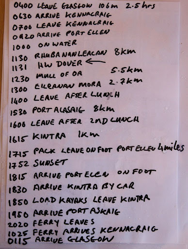
Glasgow Green to Erskine.

Erskine to Port Glasgow.

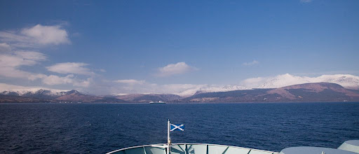
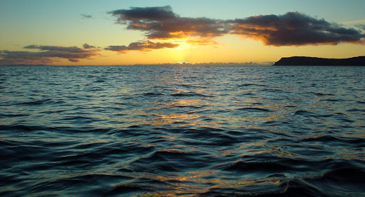
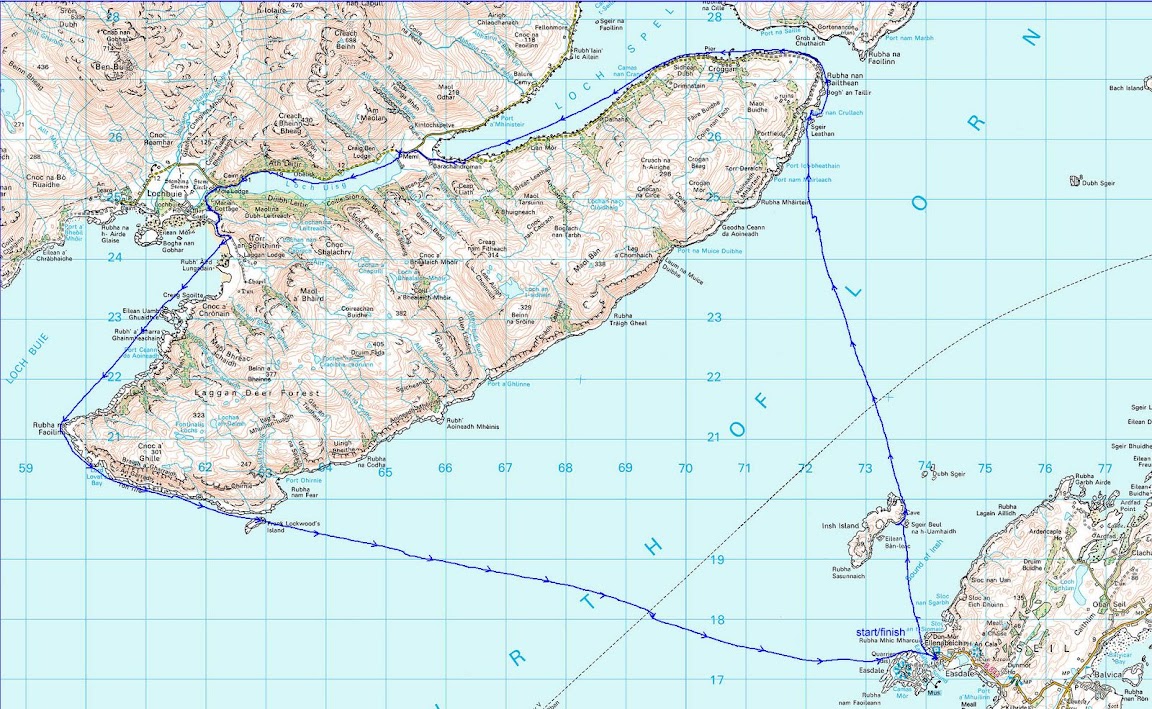
A 33km day paddle on the tidal reaches of the river River Clyde from Glasgow Green to Port Glasgow.

The Arc frames the Glasgow Tower.

HMS Dragon undergoing final fitting out at BAE Systems yard at Scotstoun.
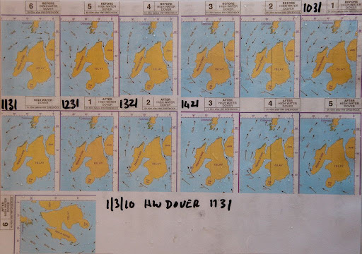
Tides
HW Port Glasgow: +0010 HW Greenock
HW Glasgow: +0020 HW Greenock
Streams turn about local HW and LW.

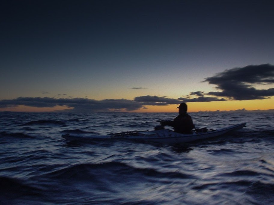
We launched at 2 hours before HW Glasgow, 5 days before springs. We took 7 hours 40 minutes to complete the trip as we spent a lot of time on the first section to Renfrew. The ebb current became noticeable at 1 hour after HW Glasgow about 8km down stream at Scotstoun. It was moving at 5km/hour and persisted at this rate until 2 hours after HW, by which time we were 17km downstream at Erskine. Beyond Erskine the ebb remained about 3km/hr until we reached Port Glasgow, 30 minutes before local LW.

Note that large ships will manoeuvre on the section up to the KGV dock, timing their arrival or departure for HW Glasgow. There is plenty to keep you occupied further up river before then, so that you pass KGV dock well after HW.

Until recently, Clyde Estuary Control would only let a yacht proceed further up than Bowling with advanced written permission. Canoes and kayaks were only allowed to make the trip as part of an organised "Annual Clydeport Paddle" trip with safety cover provided by the Glasgow Humane Society.

Although this trip was carried out with the permission of Clydeport on the day and the knowledge of the SCA, it should be seen as a trial run. Details have yet to be finalised but it is hoped that trips by competent individuals will shortly be allowed. It is likely that the protocol will be similar to that which we followed on the day, which is outlined below. The SCA will post final details on their website once they are informed by Clydeport.

Before setting off, you should contact Clyde Estuary Control on VHF channel 12, tel: 01475726221, who will inform you of any shipping movements or whether seaplanes are expected to land/take off and warn of areas to avoid, which side of the river to follow etc..

You can download the Clydeport Marine Leisure guide from their website.

You should also contact Clyde coastguard on channel 16, tel: 01475729988 and contact them again once you are off the water. You need to carry a VHF and listen for warnings on channels 12 and 16. You also need to leave your VHF call sign with the coastguard.

Launching/landing sites:
The access gates at Glasgow Green below the tidal weir are locked with a combination padlock. The current combination can be obtained from the Scottish Canoe Association or Sue Hilder, Glasgow City Council Outdoor Access Officer. Tel: 0141 287 8585.

From Glasgow Green, there are no places to land until you get to the slipways at Renfrew and Yoker, which are in use again by the current landing craft style ferries. The ferry crew did not object to a small group of three kayaks landing there for a break, because we kept well to the edge of the slip. I would not choose to stop with a large party, launch or take out there due to the ferry operations.

The next suitable launch and landing sites are at the Erskine and Old Kilpatrick slipways of the old Erskine ferry.

Downstream the traditional kayak launching site at Bowling (Canoe Boys) is now very difficult since the canal basin was redeveloped, unless you have a trolley and are prepared to drag the kayak through the woods on a dog walkers' track beyond the cycle shop in the old railway arch. However, it is an excellent place to stop for a break.

Downstream at Dumbarton Rock park near the Bowling club where you can launch at mid to high tide. At low tide you can launch into the Leven on the NW side of Dumbarton rock. The mud flats east of Dumbarton Rock are part of the Inner Clyde SSSI and are a special protected area (SPA). They are supposed to be important winter feeding areas for waders such as red shank and oyster catchers but anytime I have been there at low tide, I have seen none, though we saw plenty higher up river towards Bowling from our kayaks.

Still on the north bank park and launch here at Ardmore Point at high tide or trolley along the path at low tide.

On the south bank Kelburn Park near Port Glasgow is good at mid to high tide. Newark Castle (Lamont's) slipway is good at all states of tide. Still in Port Glasgow, Coronation park slipway is good at mid to high tide, not sure about low tide.

I would not leave a car overnight at any of these locations.

Sea kayaking from a dear green place.

Sea kayaking the River Clyde: Glasgow Green to the Merchant City.

All Greatness Stands Firm in The Storm.

Famous for not being able to walk in a straight line.

The Clyde, a river of change.

Forward paddling, through the years, on the Clyde.

A tale of two Clyde Titans; one is still standing.

Duncan takes a final curtsy on the Clyde.

Life and death on the Clyde.

Bowling down the Clyde in the Comet's wake.

Clyde built: tough ships, tough people.

Photo Album map.

Wednesday, May 12, 2010

No egos at Portencross!


When we arrived at Ardrossan on sunny morning in early March, the flags in the ferry's rigging were snapping in the wind. But we were protected by the high sea wall and could not see the sea, so we left two shuttle cars and drove the other two cars with the kayaks to Portencross. We planned our usual route, Wee Cumbrae, Bute, Sannox, Brodick and ferry home. There were white horses to the horizon as SW F5 wind blew across the Clyde from Arran. The waves were crashing in on the rocks. It looked like it might be a tricky launch. Tony, Jim, Phil and I looked at one another and, as one, shook our heads. There are no egos at seakayakphoto.com. We are at the gentlemen end of the sea kayaking spectrum. There was just time to return to Ardrossan! Plan B was to ferry glide across to Brodick on Arran and enjoy a Calmac breakfast aboard MV Caledonian Isles!

Unusually we were asked to to tie the kayaks up to the ferry's sides on the car deck. The crew expected a rough crossing. Phil felt a little queasy after his second sausage but later as the ferry pulled into the shelter of Brodick Bay, her motion eased and stomachs settled.

Monday, May 10, 2010

Sea kayaking round the Mull of Oa, Islay


A 26km paddle from Port Ellen to Kintra round the Mull of Oa Islay early March 2010.

Tidal streams 200m off the Oa peninsula at spring tides run at 4-5knots:
NW going flood begins HW Dover (11:31 on the day) overfalls off Rubha nan Leacan
SE going ebb begins -0610 HW Dover overfalls off Mull of Oa

However, we found that close inshore, the NW stream begins at least -0100 HW Dover.


A bottle nose dolphin off Sgeirean Buidhe.


Bottle nose dolphins


Soldier's Rock.


This was a day trip from Glasgow, made possible by a temporary late evening sailing from Port Askaig. I do not normally make such a rigid timetable but given the distances, ferry times and tide times it was essential. As it happened, we arrived at Kintra at 15:45 and used a taxi to recover the car. What a day!

I have mentioned both before but two really excellent sources of information on Islay are:

Armin's Islay Blog

Ron's Islay Weblog


This was the tidal atlas, marked up with the times for the day. We were there 2 days before springs.

Day return to Islay, please.

The most southern point of the Hebrides.

Oa what a beautiful morning, Oa what a beautiful day!

The SE coast of the Mull of Oa, Islay

The point of no return, Rubha an Leacan to Gob an Rubha Dhuibh, Oa, Islay

Sea kayaking with dolphins at the Mull of Oa

Going with the flow, round the Mull of Oa!

A glimpse of distant white shell sand promised a break.

Oa what a paradise!

The most southerly Gargoyles in all of the Hebrides

Oa speak no evil

Threading the Oa of a needle

All hail Soldier's Rock, Islay

What a geo on Oa!

End of an Islay day.

Oa, I'm so sorry about all the dreadfull puns.

Photo album map.

Wednesday, April 07, 2010

A night crossing of the Firth of Lorn by kayak.


As we left Loch Buie and entered the Firth of Lorn we encountered a large swell rolling in from the Atlantic. In the distance we could see the rounded outline of Scarba on the far side of the Firth.


Once round the point, the swell subsided and we passed close under the mighty cliffs of An Garradh. Mull has a reputation among climbers for rotten basalt rock but these cliffs looked superb. I wonder if any climbers have been here? The cliffs were lit by a lovely warm light except for the tops which were in the shade of some low cloud on the western horizon.


The sun set at 1715 and a cool NE wind began to get up.


In the fading light, we continued along the base of the cliffs and paddled inside of Frank Lockwood's island. This is no more than a flat skerry. Lockwood, 1846-1897, was Solicitor General of Scotland. He and the 21st MacLaine of Lochbuie were married to sisters and the two men became good friends. I suspect the island was named as a joke, Frank certainly would not have made much of a living from it.


At 1735 the light was fading fast and we had started on the final 16km open crossing to Seil. The waves began to build as we became more exposed.


We hit a F3-4 45 degree headwind and an adverse 1 knot tide. Most of the crossing was by starlight and we could only feel and taste the waves. We eventually landed at 1940 (nearly two and a half hours after sunset) after covering a total distance of 44km.


The GPS track shows where we took two brief breaks and were carried down wind and tide. After the second break we stopped maintaining a ferry angle to keep on the GPS bearing to Seil. We could see the lights of Easdale and just paddled straight for the them. You can see how the 1 knot tide and wind then carried us off course.

The backup plan, if weather turned before we left Loch Buie, was a rather decent B&B on Mull.

We do most of our paddling in winter on day trips so we are quite used to coming home in the dark. We are fair weather paddlers and so carefully watch the weather forecasts beforehand. I checked tide times and flows and marked up our maps with the details, I also checked the times the Colonsay ferry would cross our route and made sure we were not there!

For the crossing we had 5 head torches for the three of us and spare batteries, VHF radios and listened on 16 for the MSI weather broadcasts, EPIRB, rocket flares, daynight hand flares, laminated maps, compasses and mapping GPS. For most of the crossing we paddled three abreast for ease of maintaining contact.

We all had dry suits, goretex fleece lined mountain caps and pogies and carried spare neoprene gloves and balaclavas. Under the dry suit I wore Fourth Element Arctic gear which is a thick double fleece.

In case there was a problem after we left Loch Buie, we also carried spare Buffalo jackets and trousers and a 4 man bothy bag and foam mats to sit on. Spare food, water, stove, lighter, dry kindling, first aid kit and boat repair kit. If the wind did get up (we also had an ebb tide to contend with) and we could not get uptide and upwind to Seil, we could have made a run for the east coast of the Garvellachs and bivvied there or, if it was open, used the bothy on Garbh Eileach.

If the weather got right out of hand, we had short tow ropes with which we could have maintained a raft and run before it, towing a drogue. If real s**t had happened I could have let the EPIRB off but it would have had to be pretty bad to do that, after all I didn't let it off when I dislocated my knee on Gunna!

Thursday, February 22, 2007

Mackerel sky.


"Mackerel sky, mackerel sky - never long wet, never long dry. "

Is there any truth in this piece of folklore?

A mackerel sky is composed of patches of altocumulus cloud. It represents a layer of unstable and humid air which often follows a ridge of high pressure and precedes a warm front by about 400km. As warm fronts move about 50km/hr you can expect a change in the weather in about 8 hours. This was taken at 11am on our trip from Loch Sunart to Mull on 18/2/07. The wind picked up to force four from the SE by 12:00. By 14:00 the wind had increased to force 5 and it clouded over by 14:30. It was raining by 23:00.

On Saturday 17th February, when we were planning our trip, Scotland was under a ridge of high pressure and there was no wind. Sunday 18th dawned clear and still but the BBC forecast for Tobermory and Mull was for 17mph SE winds. The met office inshore forecast issued at 0600 UTC on Sunday 18 February 2007 for Mull of Kintyre to Ardnamurchan was:

Wind southeasterly 5 or 6, occasionally 7.
Precipitation: rain then showers.
Visibility: moderate or good.
Sea state: Moderate occasionally rough.

Although apparently sheltered, the Sound of Mull can be very rough especially in wind against tide conditions. LW Oban was at 12:35, 1 day before springs. Streams in the Sound of Mull change at HW and LW Oban. The flood flows to the NW and the ebb to the SE. When we crossed the Sound we had force 4 SE wind against the last hour of the ebb and it was rough in the middle. Although the wind was forecast to increase later, we enjoyed our stop at Tobermory as I knew that by that time the flood would have started and being with the wind, it would flatten the water. This is exactly what happened.


The white horses disappeared and the water flattened as the flood built up speed. We had a trouble free paddle back to the shelter of Loch Sunart.