Showing posts with label navigation. Show all posts

Wednesday, February 05, 2014

Remember to take your tide tables to Seil.

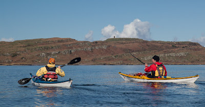
Gradually we crossed the Firth of Lorn and the Isle of Seil began to dominate the view ahead.  However, we were so enjoying the fine weather that we had not...

 ...been keeping a close enough eye on our transits and the big spring ebb carried us down the Firth of Lorn past the island of Easdale. It was now approaching midday and the forecast SSE F4 to F5 wind arrived. By now we were in the lee of the former slate worker's cottages on Easdale. The wind whipped across the flat water in Easdale Sound but we were not concerned. However, out in the open Firth of Lorn a steep wind against tide sea soon  built up. Our early start had been well worthwhile.

All too soon we landed on a slate beach at Ellenabeich and loaded the boats onto the trailer for the journey home. This corner is a recognised launch spot but whatever you do don't leave your car here or drive it on the grass. This will upset one of the local residents. There is plenty of parking just a short walk away.

This is a great part of the world for an overnight trip but it is equally suited to everything from day to multi week trips. The strong tides and variety of islands in the area (not to mention large car park) makes Ellenabeich on Seil one of premier sea kayaking embarkation points on the West Coast. Just don't forget your timetables.

We used the height of the spring ebb tide to take us SW down to the Garvellachs. We then ferry glided across the NE going flood, using it to carry us NNW to Loch Buie on Mull. The following morning we left Mull on the last of the NE going flood but were caught by an increasing SW going ebb as we approached Seil, which explains our "S" shaped course. In the area HW is morning and evenings at springs and midday and midnight at neaps.

Tuesday, December 10, 2013

The view from the summit of Little Ross Island.

From the summit of Little Ross Island we looked west down to the waters of The Sound with the point of Fox Craig beyond. It is often instructive to view paddling conditions from above.

From sea level, just 20 minutes before, the wide angle lens made the conditions look much calmer than they actually were.

The tide race was swirling round the south end of Little Ross and this was wind with tide! This large yacht was making her way up to Kirkcudbright from the Isles of Fleet where she had spent Saturday night. She had reached down under foresail alone. Because there was live firing on the range she.had to pass within 200m of the SE shore of Little Ross so she started her engine and motor sailed in before hoisting her main once in the more sheltered waters of the bay.

This is the view east from Little Ross and all the sea and land in the photo is in the exclusion zone when the range is firing. In the middle distance, Gypsy Point marks the far side of Kirkcudbright Bay. In the far distance, Abbey Head is 7km away and the firing range extends a further 3km beyond it. Despite the wind, the noise of medium and large calibre firing travelled far over the water.The flood tide runs east along this coast and the ebb west. At springs the tide makes 4 knots in each direction.

As we did not want to paddle north up Kirkcudbright Bay against the 3.5 knot ebb tide (I stopped using my Greenland paddle for everyday use after the last time I did that!) it was now time to make our way back to our kayaks to catch the end of the flood. The lower light at the north end of the island is aligned with the lighthouse astern  to give a transit for boats to find the start of the buoyed channel up the River Dee to Kirkcudbright.

As we approached the store at the west quay, the Gallovidian III was still at anchor on range duty but the other recreational boats were already making their way up river to avoid the ebb tide.

Monday, December 09, 2013

Murder at Little Ross Lighthouse.

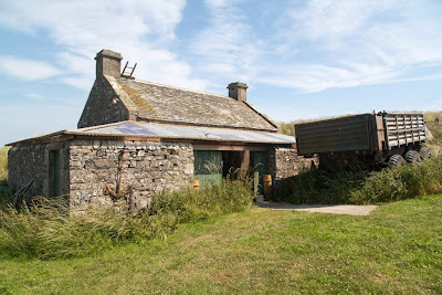
Near the west quay at the north end of Little Ross Island lies an old workshop and store. An old Alvis Stalwart 6WD amphibious vehicle was parked next to the store. We thought we would be safer crossing the Little Ross Sound and Ross Roads in our sea kayaks.

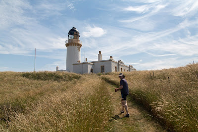
 From the store a track leads up to the summit of Little Ross, which is crowned by the lighthouse.

Half way up, on the east side of the track, some cottages and an old smithy are adjoined by a walled garden. The garden belonged to the principal lighthouse keeper.

The Little Ross lighthouse was the first built by Alan Stephenson and was lit on 1/1/1843. The light flashes white every five seconds.


It was the first lighthouse in the world to have a catadioptric design, which meant that the beam was focussed with both lenses and mirrors. At the time the famous physicist Lord Kelvin ranked it (along with the lighthouses at Rhinns of Islay and Buchan Ness) as one of the top three lighthouses in the World.

In 1960, the light was one of the very first manned lights to be automated. This was precipitated by the tragic murder of one of the keepers by his assistant. There is a moving first hand account by David Collin, one of the people who discovered the murdered man, on the Kirkcudbright community website.

Saturday, April 06, 2013

Hatching a cracking plan on Eigg.

 We left Rum with the fog swirling round the foothills of the Cuillin.

Ahead in the murk the Island of Eigg lay 9km ahead of us and  for a long time we paddled using GPS, and compass. We were bound for Camas Sgiotaig at the north west end of the island.

 Eventually the mist lifted and we could make out the outline of Eigg...

 ...to the south west lay Rubha an Fhasaidh while...

 ...to the north east Sgorr Sgaileach...

... caught the sun.

 The silence of the open crossing was replaced by the crash and roar of the surf as we approached Eigg...

 Fortunately there was a pattern of bigger sets followed by a quieter period. So we waited for the right moment then...

 ...made a run into the beach. The spume was hanging heavily in the air and it was a relief...

 ...to be able to walk up the beach without having been trashed in the surf.

It was while we were having second luncheon on the rock slabs below the towering ramparts of Dunan Thalasgair that we hatched our plan. Our original intention had been to paddle down to the next sandy bay... Bay of Laig and leave the kayaks there and walk up to the B&B at Lageorna situated in the township of Cleadale.

Howeve,r the size of the surf breaking on the reefs made us concerned in case we were trapped by a rise in the swell overnight. So we decided to take advantage of the light wind and paddle all the way to the south of the island and leave the kayaks at the jetty in Galmisdale then walk the 7km back to Cleadale. The big advantage of this plan would be a guaranteed easy launch the following day and it would leave us close enough to Muck that a near circumnavigation would be possible before nightfall.

Tuesday, March 26, 2013

Canny mariners ken ye cannae whack Canna harbour at sunset!

We set off from Rum to Canna at 16:37, exactly 1 hour before sunset and 3 hours and 39 minutes into the north going tide (which was 2 days before springs). I have used Canna harbour quite a few times on yachting and sea kayaking trips, so I was confident it would provide a safe haven (and camp site) for the night. We set off knowing that the maximum spring rate in the middle of the Sound of Canna is 1.5 knots but near the east coast of Sanday it is 4 to 5 knots.

I had set a GPS way point on the east end of Sanday and using a combination of maintaining the bearing from our current position to the way point, transits and seat of the pants, I think we did a damn fine job of the crossing.

 Slowly the sunlit mountains of Rum...

 ... receded behind us and we found ourselves...

 ...in the shade below Sanday lightouse. Although situated on Sanday, this is officially known as Canna lighthouse to differentiate it from the light on the isle of |Sanday in the Orkeney Islands. It was built in 1907 and flashes white every 10 seconds.

We took a breather once we were out of the main tidal flow but even here a buoy was being tugged under the surface!

There is absolutely nothing to beat the feeling of paddling into the sheltered waters of Canna at sunset. There is no better harbour in hundreds of square miles of the exposed waters of the Sea of the Hebrides. Mariners have sought safe haven here for thousands of years and we were delighted to do the same.

 The sun was setting behind the dramatic outline of...

 ..the former Roman Catholic St Edward's Chapel on Sanday. It was renovated in 2001 to be used as a Gaelic study centre but for various reasons has yet to open its doors.

 On the north side of the harbour the sun was shining on the Church of Scotland church.

As it was approaching high water we paddled deep into that part of Canna which...

 ...dries out at low tide. The sun was setting as we paddled...

 ...under the bridge that connects Sanday to Canna and made our way out into...

 ...the open sea of the Hebrides beyond.

The sun had set by the time we had hauled our kayaks out onto one of the white sand coves that can be found on this coast.

Wednesday, November 28, 2012

We set off in the general direction of Little Cumbrae.

We set off from Largs in the general direction of the  Little Cumbrae.

We had originally intended launching at Portencross, 9km south of Largs because the wind was forecast to be F3-4 SW, backing 4-5 SE increasing 6. When we arrived at Portencros,s the wind had already gone round to the south and was a fitful F4 gusting to 25knots. We decided to move up to Largs, which would allow a reach out to Little Cumbrae and back in a SE wind.

In the shelter of the Largs hills, the wind was a lot less than at Portencross (well beyond the cranes on the horizon). However, it had already gone round to the SE, which allowed us to lay the end of the Little Cumbrae on a very tight reach.

 As we approached Hunterston, Phil noticed...

 ...two new masts. They are anemometer towers to test the wind prior to building 3 huge (198.5m) test offshore wind turbines for the SSE company. About £180 per year of every UK electricity bill is used to subsidise building such monstrous devices.

As we drew level with the port no 9 buoy of the Hunterston Channel, off the south end of the Great Cumbrae, it was apparent just how much all the recent flood water had increased the flow of the neap ebb tide. It was now two and a half hours after HW and the tide was zipping past the buoy. With the increasing wind against the tide, we knew we would be in for a rough crossing to the Little Cumbrae....yippee!

Tuesday, April 10, 2012

Only a moment's hesitation on the Firth of Clyde.

Phil, Tony and I convened at Portencross Castle on the Firth of Clyde.

Although it was a windless morning, you will notice we still took sails. We were expecting a F4 NW wind to get up later in the afternoon. Our plan was to paddle up the west coast of Bute, take some luncheon, wait for the wind then have a blast back with the sails.

 Phil's kayak was wearing its new Skippy badge.

It wasn't long before we crossed the Hunterston Channel on our way to...

 ...Gull Point on the Little Cumbrae Island.

 The rumble of a heavy diesel from the direction of Arran announced the arrival of...

 ...the MV Seaprincess, a tanker with a  a DeadWeight of some 115,949 tons travelling at 11.6knots. She was heading up the Firth of Clyde Channel to the oil terminal at Finnart on Loch Long, a further 46km up the Firth of Clyde.

We engaged in a debate about whether to nip across the channel in front of her, a debate which lasted all of 2 seconds...
...before we slowed to let her pass. She also slowed at the south end of Bute as the Clydeport pilot vessel, MV Mount Stewart, raced in to drop the pilot off.