Showing posts with label Wigtown Bay. Show all posts

Tuesday, January 01, 2013

Seakayaking desktop wallpaper calendar 2013.

I wish a very Happy New Year to all visitors to seakayakphoto.com. As way of a celebration of the last year and in anticipation of sea kayaking adventures yet to come, here is the 9th annual sea kayaking desktop wallpaper calendar from seakayakphoto.com.

As in past calendars, all the photos were taken during the previous year (2012). Despite having been retired for a year now, I have not been able to explore wide new horizons as I had once dreamed. Increasing disability has somewhat restricted  the areas in which I have managed to paddle. This year all the photos are from my local waters of the Firth of Clyde and The Solway Firth. Far from feeling sorry about this, I have felt blessed to have the freedom to enjoy exploring my own doorstep. I am so grateful for the assistance of my friends in getting me to and from the water. My daughter Jennifer chose the photos for each month of the calendar.

2013 cover shot. This is paddle sailing at its best: sun, wind, tide and big skies, on a trip round the Little Cumbrae in the Firth of Clyde.


January.  A cold east wind sped us from Maidens to Seafield with the snowy mountains of Arran on the far side of the Firth of Clyde.


February. Some gentle swell made for interesting exploration of the rock channels of Bennane Head on Ayrshire's Atlantic Coas, Firth of Clyde.


March. Looking back to Glen Sannox after a misty crossing of the Sound of Bute, Firth of Clyde.


April. Sunset in the Kilbrannan Sound, Firth of Clyde. It was dark when we reached our camp site but the experience of night slowly gathering round you on a calm night is unmissable.


May. Clear waters in Catacol Bay, Firth of Clyde make a great place to stop for a second breakfast.


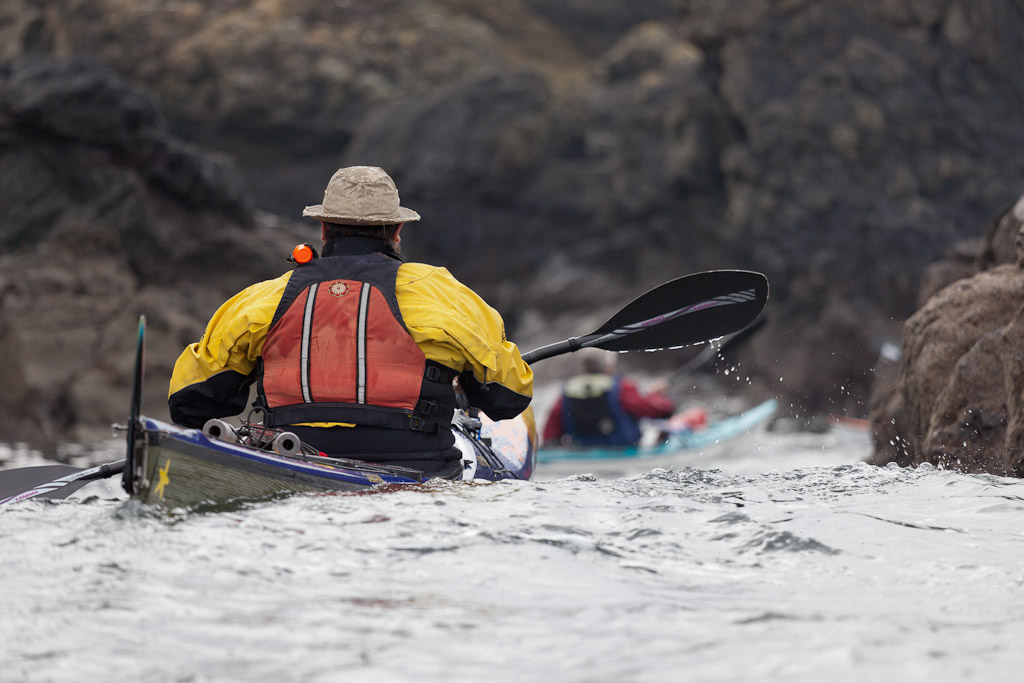
June. Rounding Bennan Head on Arran, one of the impressive headlands in the Firth of Clyde.

July. Safe haven on a granite boulder reef at Ailsa Craig, Firth of Clyde.


August. Summer rain, Fleet Bay, Solway Firth.


September. Waiting for the tide, Isles of Fleet, Solway Firth.


October. Enjoying the freedom of the seas in Wigtown Bay, Solway Firth.


November. Taking a break in Bracken Bay, Firth of Clyde.


December. Seakayak sailing to Dunure with Ailsa Craig on the horizon, Firth of Clyde.


I hope you find something to inspire you to paddle in your local waters. Finally....


Sunday, September 16, 2012

Not quite the Galapagos but natural selection is alive and well in the Isles of Fleet.

 Leaving the verdant pastures of Ardwall Isle, we set off to round...

 ...its seaward coastline.

 From this viewpoint there was little to suggest...

 ...that there was any green vegetation on the island at all. Indeed, the coastline was so primeval that we half expected to see basking iguanas round every corner.

From Ardwall we crossed to Murray's Isles. We landed on the larger isle for another break, though this little sandy beach  is covered after about half tide. We were amused to see two separate paddlers on sit on top kayaks paddle by. We thought they must be members of the DKC* as their only safety items were a pair of gloves and a cotton T shirt.

 We left the Murray's Isles through this little gap...

 ...at their western end and...

...arrived safely back a little early. Tony and Jennifer kindly carried my kayak up the beach. Tony brought his trolley back for his own kayak and was ably assisted by his daughter.

Another great trip in the Solway.

*DKC Darwin Kayak Club.

Friday, September 14, 2012

SECURITE on the Solway.

It was a neap tide down on the Solway. There was no time to waste as this meant that the tide would soon be out, exposing the sands of Fleet Bay for most of the day...

...so Tony, Jennifer and I set off early to catch the the ebb tide before the bay emptied. We planned to stay out on the open Solway for about 6-8 hours until the flood filled the Fleet again. A force three NE wind sped us on our way as we crossed the tidal bar that connects Ardwall Isle to the mainland and...

 ...made our way out towards Barlocco reef beyond.

We took a break on Knockbrex beach for our first luncheon. Jennifer did well in the Delphin to keep up with the kayak sailors. We did not stay long as the reef that connects Barlocco to the mainland was rapidly drying.

As we approached Meikle Pinnacle Jennifer pointed out a flock of gannets diving on a shoal of fish.

The swell began to increase as we rounded Ringdoo Point. We had planned to paddle round to Kirkudbright Bay as we should have been in the lee of the land in the forecast 3-4 NE winds. The winds were due to veer SE and increase in the evening so we should have had plenty of time to get there and back.

As we left the shelter of Wigtown Bay the wind increased and veered SE and the swell began to increase. The ebb tide runs to the SE out of Wigtown Bay but as you approach the entrance it joins the ebb from the Solway which runs to the west. We were therefore paddling in glorious sunny wind with tide conditions with nice smooth swell.

All of a sudden the VHF crackled into life "SECURITE,  SECURITE ,  SECURITE ." It was Liverpool Coastguard with a strong wind warning for small craft.. Winds were to veer to the SE and increase to force 6 imminently. This put us in a difficult position. Imminent means within 6 hours but the wind had already veered and increased and we were enjoying ourselves now. However, the tide would turn and start running east long before we would get back from Kircudbright Bay. Wind against tide in the shallow waters of the Solway creates the "White Steeds of the Solway" which are best avoided so we decided to
turn back towards...

 ...the now distant Ringdoo Point. We made rapid progress towards...

 ...the point in the following seas.

 Soon we were in the shelter of the cliffs and all appeared to be calm again.

We paddled round the seaward side of Barlocco and landed in a sheltered cove on its lee side. We arrived at low water so we had plenty of time for a leisurely second luncheon until the tide came in sufficiently to kayak back into Fleet Bay. It was a different world in here as we sat in the shelter of the reef looking towards the Islands of Fleet and the distant Galloway Hills. For a moment we wondered if we had done the right thing in turning back. However, when the tide turned, out at sea the Solway horizon had become very lumpy...

Friday, March 18, 2011

Common sense prevails in Wigtown Bay.

This wonderful, wild seascape in Wigtown Bay has been under threat of industrialisation by the installation of 90 giant windmills. All would be situated within the confines of the bay, with the nearest being only 4.5km from the shore. Fortunately, for those that do not put natural beauty above greed for energy, the BBC Scottish News today announced that the Scottish Government turned down the application to develop this sensitive site. I am not a NIMBY, as I live just 5km from the largest onshore wind farm in Europe. I quite like it, though its rotors hardly turned during the last two record, cold winters.

Rather more surprisingly, they have also turned down the application to extend the Robin Rigg wind farm, further up the Solway, from its current 60 turbines to 160. This farm is further offshore, at 9km, but apparently its power output is much less than predicted and it would not survive economically without a massive subsidy paid for by UK electricity consumers.

I am glad that these particular proposals have not gone ahead. I particularly like Wigtown Bay and I would have hated to see it spoiled, just so I could leave my computers at home and at work running overnight. Thank goodness the Scottish Parliament has made a common sense decision. Of course the forthcoming election, on the 5th of May, has no doubt helped them come to their decision!

Wednesday, March 16, 2011

Sea kayaking round Burrow Head.

A 32km day paddle from Port William round Burrow Head to Garlieston, Solway Firth,  January 2011.

Approaching Burrow Head near slack water.

Tides
Well off Burrow Head: 
The east going flood starts -0600 HW Liverpool (-0545 HW Dover). 
The west going ebb starts at HW Liverpool (+0015 HW Dover) 
The spring rate is about 3 knots. 

Close in to Burrow Head:
Strong counter eddies become established in the last 2 hours of the flood and the ebb, so close in, the tidal flows turn two hours earlier than the above times: 
The east going flood starts +0430/-0800 HW Liverpool (+0415/-0745 HW Dover). 
The west going ebb starts at -0200 HW Liverpool (-0145 HW Dover) 


Close in the spring rate is about 4-5 knots and there is turbulence at the eddy line. This means that "slack water" close under the rocks occurs when the main race is still stonking off shore. If there is any wind against tide, the main race will look quite scary and the eddy line will create very confused water. As you are approaching the head, to take advantage of the inshore slack, you will see great lumps of water from the main race heaving on the horizon and you can have a bit of a dry mouth before you round the corner and actually see what it is like.


Saturday, March 12, 2011

Home to roost in Garlieston.

We had enjoyed our sojourn in the Isle Whithorn so much that, by the time we left, the whitewashed houses had a pink glow from a sun that was already sinking in the west.

On leaving the harbour we turned our backs to the sun and turned east...

...into the broad expanse of Wigtown Bay.

We made for Cruggleton Point...

...which is topped by the remains of Cruggleton Castle.

By now the sun was setting and a cold sundowner got up from the east.

Rigg Bay, with its large tidal range, has some similarities to the Normandy coast and was the site chosen to develop the Mulberry harbour modules used in the D Day landings in WW2. Several modules are sunk in the bay.

We landed at Garlieston as the last pink glow of the day left the sky. We witnessed a magnificent display  by a huge flock of starlings coming into roost. Now we had to find our way back to Port William in the dark!

Friday, January 14, 2011

Tight ropes on Slack Heugh.

The SW coast of Meikle Ross has steep cliffs extending from Fox Craig along to Slack Heugh.

They are a magnet for rock climbers as there are a whole range of routes right up to E numbers.

We still had a little tidal assistance, though we were now out of the main ebb flow from the Solway. We soon found ourselves at Manxman's Rock...

...then the westcoast of Barlocco Isle. Phil tried to cross the rocky bar, which connects Barlocco to the mainland at low tide. He ended up having to do a solo portage!

The tide was well out by the time we got back to Ardwall and Carrick shore. The sand is pretty firm to the south of Carrick and it is worth sticking a trolley in your kayak, if you plan to take a diversion up the Dee to Kirkcudbright for fish and chips.