Tuesday, October 04, 2011

Flotsam, jetsam and kayaks off the Rinns of Islay.

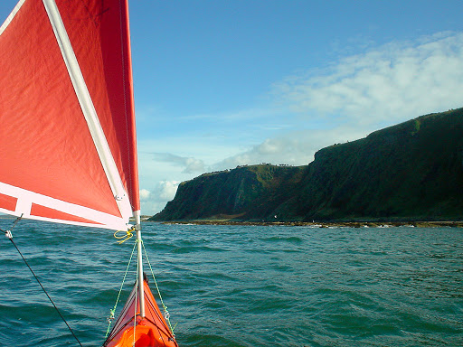
From Lossit Bay to Machir Bay the rocky ramparts of of the Rinns stretches for 8km almost unbroken. Kilchiaran Bay is the only breach in this coast's impenetrable armour but it was full of surf so we pressed on to Machir Bay. When I say "we pressed on", I am perhaps implying we had somewhat more choice in the matter than actually existed, given the reality of the building north going tide and force 4 tail wind.

We kept  well out (2km) from Machir Bay and the conditions moderated a little. However, it to be a short lived respite. The west coast of the Rinns has a series of headlands round which the tide races. They have confidence inspiring names like Rhuba na Faing and Cape Fear. We were rapidly approaching the headland at the north end of Machir Bay. It was two and a half hours into the flood and the tide was fair steaming along. This particular headland consists of an offshore island and a channel littered with exceedingly sharp dark rocks. The island acts like a funnel and the tide accelerates through the channel like a venturi, carrying all flotsam, jetsam and kayaks with it. The surging swell, the rushing tide, the broken, white water receding and revealing fangs of black rock... it all led to an involuntary clenching of the jaws not to mention the gluteal muscles.

After all this excitement, the fair weather we had enjoyed thus far deteriorated a little as we passed Saligo Bay. The clouds descended, it started to rain, the temperature dropped and the wind increased. This was after all the first week in August... always a risky time to go paddling in Scotland.  We were now passing "Opera House rocks" which are more properly known as Dun Bheolain, site of an Iron Age hill fort. It is surrounded on three sides by surging surf, I don't think they would ever have expected to have been invaded from the sea.

Ahead lay Cape Fear, where we hoped to turn east rather than be swept away by the tide to the north. It was three and a half hours into the flood and we could see the tide race heaving over the reef that extends far to the north west. We kept well clear of the reef but the wild waters of the race took all our attention as we slowly turned our bows east. We paddled with a new vigour and the water was soon rushing beneath our keels.  It was still rather rough and it was all we could do to keep paddling for the next headland Ton Mor.  It seemed to be a very long way away and it wasn't getting any closer.

Then I was knocked sideways by a particularly big wave and I was amazed to see that we were still beneath Cape Fear! All that paddling had got us nowhere, an uncharted west going eddy was running against us and joining the north going flood! It was time for a quick decision. We moved closer into the cliffs where the clapotis was horrendous but where we hoped the foul tide would be less....  

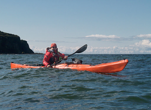
I must apologise for the lack of decent photographs on this particular trip.                                                                                                                                    

Monday, October 03, 2011

Commitment off the Rinns of Islay.

Leaving the shelter of Portnahaven at slack water, we entered the channel between Islay and the offshore islands of Orsay and Eilean Mhic Coinnich. Despite being "slack", the north going tide was already ripping through the channel at 3 knots.

The islands and the Stevenson lighthouse on Orsay were soon left astern and we were now committed, there could be no turning back.

We were whisked past a curious concrete structure. This is the Islay experimental Limpet wave generator.

We were now  on the open Atlantic. The photographs do not give a true idea of just how rough it was. It was obvious to us that we were not going to be landing on the surf beaches. Lossit Bay was "smoking" as the cross off wind blew the crests off the back of the surf sets.

Gannets, heavily laden with fish, were using the shelter of the cliff line to make their way south towards their hungry chicks on Alisa Craig, which was over 100km away.

Off Lossit Point, the sea was even rougher. The rocks of Beinn Seasaimh, 139m, fell steeply into the sea and it was pretty obvious we were not going to be able to land until we had cleared the west coast of the Rinns of Islay, after paddling for 25km...

Sunday, October 02, 2011

Dry mouths in the deceptive calm of Portnahaven.

Tony and I had been trying to complete kayaking round Islay for several years and despite frequent visits, we had been unable to paddle the west coast of the Rinns of Islay. This was to be my third visit of the year and only a few weeks before, had already turned back from the Rhinns after meeting huge swell in otherwise benign conditions. Prior to this trip, a succession of days with SE winds had flattened the Atlantic swell, which is the "Governor" on this coast. Although the weather was to be mixed, the tide times were ideal. It would be one day after neaps and the north going flood would start at about 0900 hours at Portnahaven on the south end of the Rhinns.

It was 0820 as we drove down the steep road into the tiny hamlet of Portnahaven. The hamlet almost impossibly manages to cling to the rocks of this untamed coast. In the shelter of Portnahaven it was difficult to judge the wind strength as it was SE and offshore. The smoke blowing horizontally from the chimneys suggested it was about 3-4. It was time for the Clyde coastguard Marine Safety Information (MSI) broadcast on the VHF marine band.

"This is the inshore forecast for Mull of Kintyre to Ardnamurchan Point, issued by the Met Office at 0500 UTC Friday 6th August and valid until 0500 UTC Saturday 7th August. 24 hour forecast. Wind: SE or S 4 to 5 veering NW 6-7 later. Sea state: moderate or rough becoming very rough. Weather: showers, rain later. Visibility: moderate becoming poor."

"Later" means 12 hours or more by which time we hoped to have cleared the Rhinns. The SE or S would either be cross offshore or cross shore as a tail wind so we decided to go for it...

...and after several visits to the public toilets, we launched in the calm of Portnahaven harbour. We passed the conveniently situated pub, An Tigh Seinsse (house of the singing) but it was shut and our mouths remained dry.

Portnahaven was built as a planned crofting and fishing village during the 19th century...

...and its cluster of whitewashed cottages crowd round a sheltered inlet off one of the roughest pieces of water in the British Isles. None of the local boats showed any sign of leaving their moorings that morning. A combination of Atlantic swell, strong tides, shallow, reef infested waters and high average wind speeds make it an interesting place to kayak...

...these were the conditions which had caused us to turn back a few weeks before.

Saturday, October 01, 2011

An Islay retrospective.

Partly due to my deteriorating knees and partly due to the recent weather, I have been doing less sea kayaking recently and as a result my recent trips have been short half day trips, usually from Ayr. I find it difficult sitting in a kayak for a long time and do not like long car jointures. To provide some variety for the blog, I am going to dip into the back catalogue and where better to start than a return to the magnificent island of Islay?

It was an evening in early August when Tony and I caught the last ferry to Port Ellen on Islay's south coast. In truth that summer wasn't much better than this one and while we were on the crossing dark clouds were rolling over the summits of the Paps of Jura.

We drove to a remote area of the island and set up camp at 9pm just as...

...the sun was setting. The seals were singing to one another on the sandbanks in the bay. We had an early night as we were all set for a big day in the morning...

Friday, September 30, 2011

Sea kayaking round Little Cumbrae.


A 22km half day trip from the public slipway at Largs Marina round Little Cumbrae, September 2011.

Rounding Farland Head, Great Cumbrae after a windy crossing of the Tan from Little Cumbrae.


Luncheon with the Little Cumbrae terriers.

Glorious sun, wind and waves at Gull Point.

Thursday, September 29, 2011

Glorious sun, wind and waves at Gull Point.

We set off from Little Cumbrae castle into 14 knots of wind from the south which was blowing against the south going tide. We knew it would be lively at Gull Point at the south end of the Little Cumbrae and we were not disappointed. This photo was taken just south of the lighthouse where the water had flattened off enough to allow me to get the camera out.

 Once round the lighthouse, we were in the wind shadow of the island and...

 ...it was very pleasant cruising gently along...

 ...until we left the shelter of the NE corner of the Little Cumbrae. Then all hell let loose until...

 ...we crossed the Tan and got some shelter from Farland Point on Great Cumbrae.

We then enjoyed a blast of a run up to Clashfarland Point where I had to stop, as my knee was really painful. When we set off again the channel had begun to get busy with two ore carriers and a variety of fast RIBs.

We decided to just paddle straight across the shipping channel but as soon as we were clear, we unleashed the sails for a final blast back to Largs marina.

Sadly, the pain in my knee has recently restricted my sea kayaking to shorter half day trips. I also don't manage sitting in a car for any length of time. However, this short, local trip proved to be an exciting day and we were home in time for afternoon tea!

Wednesday, September 28, 2011

Luncheon with the Little Cumbrae terriers.

There was a decent weather forecast and Tony and I felt like a short local paddle. So we nipped down to Largs on the Clyde coast and enjoyed...

...a lively paddle as the south going ebb met the south wind off Farland Point on the Great Cumbrae Island.

Our destination was the Little Cumbrae Island which lay on the far side of the Tan with the mountains of Arran rising beyond.

After a glorious crossing we entered the shelter of Castle Island opposite where the house is situated.

We landed in the lee of the castle for a quiet luncheon but were soon joined by Little Cumbrae's four resident and madly barking dogs, who swam out to greet us.

They soon shut up when they saw our sandwiches and clearly wanted their heads patted. It was interesting trying to analyse the genetic relationships of this motley crew of Little Cumbrae terriers.

Tuesday, September 27, 2011

Fitting a Flat Earth Kayak Sail to a P&H Delphin

When I first tried the P&H Delphin I was impressed by all the usual things: its comfortable ergonomics, its stability in rough water, its manoeuvrability, its surfing, its rolling, its behaviour in winds... but I really couldn't wait to put a sail on it. Those hard chines at the bow are just asking for a sail to provide the drive to push through the waves in front!

I mounted the pulley for the uphaul/fore stay on the front deck line recessed deck fitting (RDF). The pulley for the sheet and the back stay went on the front deck elastic RDF. The existing side deck line RDFs were just too far behind the mast to provide support when reaching or beating so I mounted two stainless steel saddles on either side of the mast and attached the side stays to them. If you were only interested in downwind sailing you could use the RDFs and do away with the back stay.

I mounted the sheet and uphaul cleats in front of the cockpit and to either side of the 4th hatch.

The ideal position for the mast base was just forward of the compass mount but the foredeck on the Delphin is peaked. Purists will be horrified but I just fitted the mast base to the right of the mid line on the flat part of the deck secured with two penny washers to spread the load below deck.

I use the same mast on my Nordkapp LV, which does not have a peaked deck. The side stays were therefore too short, so using bowlines, I adjusted loops of 2mm Dyneema cord through the saddles and clipped the snap shackles into them. If you only use the sail on one kayak you could clip the snap shackles directly through the saddles.

The beauty of the Flat Earth flexible tendon universal joint is that the mast is still vertical despite the mount and...

...the wind couldn't tell the difference!

Monday, September 26, 2011

Is it worth tacking upwind with a Flat Earth Kayak Sail?

 There was a 12 knot headwind blowing directly from our destination the Heads of Ayr.
I decided to try and tack upwind to see if it would be quicker than just putting my head down and paddling straight for the Heads of Ayr.
At first I tacked upwind while both paddling and sailing. I covered 1600m over the ground but only 600m upwind in 15.28mins. The over ground speed was 6.3km/hr but the upwind speed was only 2.4km.
Next I dropped the sail and paddled directly upwind. I covered the next 600m in 6.72mins which meant the upwind speed was 5.4km/hr.
It was good to take a rest at Bracken Bay and work all this out. My conclusion is that it is not worth tacking up wind when kayak sailing but if you can lay your destination sailing closehauled it is worth kayak sailing. In this example the close hauled speed was 6.3km/hr and the paddling only upwind speed was 5.4km/hr.
Of course the downwind blast home was much more fun...
...my maximum speed regularly went over 14km/hr with a max of 14.6

Yee Haa!