Tuesday, June 28, 2011

The Prisoner and the Village, St Kilda.

The morning dawned fair. We were all feeling a bit tired after our paddle to Dun the previous evening...

...so we decided to spend the morning exploring the village.

We waited to meet the National Trust for Scotland warden at the pier head and he introduced us to the island.

We started at the feather store...

...then moved to the gun that was installed after a German U boat had shelled the island's Royal Navy radio station in WW1.

Thrift was still flowering here but it was well past on the mainland.

Walking towards the village we passed the first of the many storage cleitean that are scattered all over the islands before making our way...

...to the island camp site (prior permission from NTS required) is in a walled field behind the church and schoolhouse.

We then walked down to the church and schoolhouse.

The class of 1886 photographed with a visitor, Mr George Murray, by N MacLeod (George Washington Wilson collection Aberdeen University). Wilson toured Britain giving many slide shows of life on the islands. The Victorians could not believe such "primitive" conditions existed in Britain. (They clearly hadn't visited many industrial cities' slums!) His collection is now held at Aberdeen University.

The class of 2011. Donald burst out laughing in class but naughty Ken got caught copying Donald's slate! 100 lines all round.


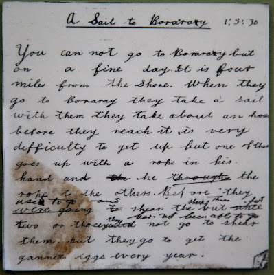
One of the last written exercises, from just before evacuation in 1930. This pupil's concentration seems to have been distracted half way through the lesson. We were struck by the words "You cannot go to Boraray but on a fine day.." We had hoped the following day would be fine to allow us to paddle to Boreray but the forecast was not promising...

The last pupil entered on the school roll was Kristina MacKinnon on the 1st of April 1929.

There are a lot of bells on St Kilda. Ship's bells are in plentiful supply.. from the many wrecks that have come to grief on St Kilda. This particular bell came from HMAV Aghelia, an Army Landing Craft that supplied St Kilda until she was sold off in 1994. The village bell no longer rings the ship's watches, it rings for the volunteer work parties to come in from the fields...

...where they are restoring and maintaining the village buildings and drains.

Ian got a good perspective for his shot along the village street.

Given my bad knee, I had to make do with a more conventional standing viewpoint.

One of the 1860's houses has been restored as a museum. Inside, another bell is displayed. It was recently recovered by a diver in  Glen Bay on the other side of the island. It had originally been fitted to SS Manor but was transferred to the trawler Kumu,  which sank on 19/2/1929.

Simon interviewed Donald who has a deep interest in and extensive knowledge of St Kilda's geology, natural and human history.

This large cleit is reputed be the house of Lady Grange who was marooned (and effectively a prisoner) here in 1734 by her husband. He was the Lord Advocate of Scotland and they both enjoyed a drink. They had separated in 1730 after years of his infidelity and her increasingly aggressive and unpredictable behaviour. She started spreading rumours that he was a Jacobite sympathiser so he had her removed to the Hebrides, first to the Monach Isles then to Hirta.

Whether this cleit was actually her house is debatable, though it is on the right site and is of the same dimensions. I wonder if this was house number six?

The cemetery lies just above the village street. Because the island's soil is so shallow, a wall was built and the inside was filled with soil to make it deep enough for burials, once a corpse had rotted the bones were moved to the side to make room for further burials.

Most of the graves are marked by simple stones but after the island was evacuated, some of the emigrants marked deceased relatives graves with modern carved headstones.

Above the cemetery you can find an underground chamber called a souterrain.

It is of great antiquity and the islanders called it the House of the Faeries. It is about 10m long and dates from the Iron Age.

Above the souterrain is the site of the medieval village, as described in Martin Martin's first hand account of a visit in 1697; "A Voyage to St Kilda" published in 1698. This mound is Calum Mor's house and is probably the sole survivor of the pre 1830's houses.

We now made our way down to the shore. Sand appears at low tide in the summer but is carried away by winter storms.

The Cuma had arranged to pick us up at lunchtime so that we could get into our kayaking gear and go for an afternoon paddle. However, all of us had become so fascinated by what we had seen so far that we decided to go for a walk round the interior of the island instead....

If the village and its history interests you, you can read about some of the other things I saw on my 2008 visit here.

Monday, June 27, 2011

An evening paddle in the lee of Dun.

The forecast was not looking promising, the wind was due to increase 5-6 from the NE, imminently. We launched from the Cuma at 6pm...

...and made for the Dun Gap in beautiful evening sunshine.

The wind and the tide were whistling through the Dun Gap as I looked back past Giasgeir, in mid channel, to Oisebhal (293m) on Hirta.

Mostly it was sheltered in the lee of Dun but there were some vicious down draughts round the headlands and one of the party capsized as a rogue swell broke over a skerry. Donald soon performed a rescue but our team mate was wearing a two piece and got bitterly cold, despite being given two extra jackets, hat and gloves. Please excuse the blurred photo, it was a bit bouncy, I was trying to see if I could offer assistance and I was desperately trying to obey director Simon's "Exit stage left" command, as he was filming the whole proceeding!

 Ian and I felt quite snug in our dry suits. We now paddled into the tunnel...

...that cuts right through An Faing

then turned hard right to go through another much smaller tunnel that leads through to the inlet of A'Chlaisir.

Some of the party then entered the cavern that connects right through to the opposite side of Dun at Seilg Geodha. There was too much swell coming through for us but Gordon got right through and back again. It was impressive seeing him being spewed back into the dark cavern on the top of a 2m wall of white water that shot out of the narrow slot!

We now continued towards the SE point of Dun...

...under towering and sometimes overhanging cliffs.

As we approached Giumachsgor we could see the tide race that was sweeping past the point of Dun. Either we could get through the arch or we would need to return by the Dun gap, we would not be going round the point!

We felt the full force of the wind once we were round Giumachsgor. We ferry glided across wind and tide to the SE wall of the arch. I just managed to hold station here. The tide was rushing through against us as was the wind, which was gusting through and lifting the surface off the sea. Gordon paddled forward into the mayhem and managed to get through to the far side. From my position, I could see through the arch into Village Bay, where he turned on the top of a large wave. He then surfed into the arch again and dodged the reef in its middle. It was an incredible demonstration of paddling skill. No one followed him through. Unfortunately the one photo, I risked taking, was of my spray deck, so you will need to wait and see the video from Gordon's deck mounted cam. I am sure this will make it into the final version of the second "Sea kayaking with Gordon Brown" DVD, which Simon is currently editing.

We returned to Hirta through a very windy Dun Gap. The crossing to the pier was quite bumpy as it was exposed to the wind and the swell that had quickly built up. Behind us, the setting sun lit up the top of the outlying stack of Levenish in a warm glow but we were now deep in the shade of the cliffs of Dun and Hirta. We securely tied our kayaks to the pier railings then Gary ferried us in the RIB back to the Cuma. We enjoyed a well deserved meal at the end of a fantastic day and went to bed early. It was a disturbed night as the Cuma rocked uneasily in the swell, her timbers creaked and the wind whistled through her rigging.

Sunday, June 26, 2011

Arrival at Hirta, St Kilda.

From Boreray and the Stacs, MV Cuma motored towards Hirta and Soay, which are the two largest islands in the St Kilda archipelago. The next two by size are Boreray and Dun. The cliffs falling from the summit of Connachair (at 430m, the high point on Hirta) are the highest sea cliffs in the British Isles.

As Cuma made her way round the east side of Hirta, we caught sight of the jagged outline of Dun.

The most easterly point on Hirta is Rubha an Uisge, "point of the water". You can see a waterfall tumbling into the sea (after our very wet start to the summer). When we were last here in 2008, there was no fall.

Dun is riddled by caves and tunnels and when  approaching from the NE, you can see through its great arch.

Dun is separated from Hirta by only a narrow gap.

We lined the bows of the Cuma in excitement, to catch our first sight of Village Bay.

The modern military base, which supports a radar station, is incongruous but does not dominate the scattering of stone built dwellings and storage cleits that rise behind it.

The first building we passed was used to store the feathers of sea birds for export. It dates from the late 18th century and so is older than...

...the alternate cottages from the 1830's and 1860's, which make up the village street. This was the most remote settlement in the British Isles, until it was evacuated in 1930 after thousands of years of habitation.

We had arrived on this archipelago of superlatives!

Saturday, June 25, 2011

Evolution of the species on Boreray.

After sweeping round Stac an Armin we aproached Boreray from the NE. What a superlative sight! It was like a great stegosaurus rising up from the ocean. We half expected to see pterodactyls swooping round its rocky pinnacles...

...but they had all evolved into gannets!

Murdani now took the Cuma through the narrow gap between Boreray...

...and a pair of small unnamed stacs which lie between Boreray and Stac an Armin. The chart encouragingly annotates this channel "no passage, even for boats"...

...but Murdani has fished for crabs and lobsters in these waters sine the '60's and  knows these waters better than any chart maker! We wondered why Murdani stayed in the Cuma's wheelhouse...

We were also astounded by the number of gannets. These are very hungry birds that have a highly efficient digestive system, to cope with the prodigious amount of fish they catch...

 Liz, Simon and...

...Calum all wore wide brimmed hats.

All were agreed, it was as well that despite 2,500million years of evolution, elephants have not learned to fly like gannets

It was humbling to see so much teeming bird life. They lived in a city in the sky..

...each pair guarding  their own piece of ledge.

 Cuma now motored close in to Stac Lee, with Boreray behind.

Sadly our encounter with the stacs was nearly over, the scale stunned our senses. It was a long time before I could get both Stac Lee and Stac an Armin in the same shot...

...and even longer before I could squeeze Boreray in as well. Archaeologists have recently found signs of permanent buildings and agriculture on the steep slopes of Boreray dating back to the iron age!

Friday, June 24, 2011

The gannets of Stac an Armin.

 The Cuma slowed as we approached the north end of Boreray. We were silenced by this view between Boreray and Stac an Armin. Stc Lee is partly hidden by the dark cliffs of Boreray, Hitra is in the distance with Stac Soay and Stac Biorach between it and Soay, then Stac an Armin.

Telephoto shot of Soay.

At 196m high, Stac an Armin is the highest sea stac in the British Isles. The St Kildans harvested seabird each summer. They built 80 cleits and a bothy on the rock. Three men and eight boys spent 9 months on Stac an Armin from  about 15 August 1727 until 13 May 1728 when they were rescued by a boat from the Outer Hebrides. Smallpox had broken out on Hirta after they had been dropped off and there were not enough adult survivors to man a boat to recover them.

Nearby Stac Lee is the second highest stac at  172m.

Stac an Armin from the NW. The last great auk in the British isles was killed here in July 1840. It was caught by three St Kildans and held captive for three days before they beat it to death because they thought it was a witch.

 The air was filled by a blizzard of croaking gannets. These islands are one of the biggest sea bird colonies in Europe.

They are incredibly graceful in flight...

...and have a wingspan of 2m.

The Cuma now swung round the south of Stac an Armin. The islanders leaped ashore from their boats at the white water below the highest point.

Track of the Cuma,