Friday, February 18, 2011

Imminent Barassie Monkeys.

When we left Lady Isle, the wind swung round to the SE and increased with a dramatic fall in temperature. Nearly 4 hours before, the Clyde Coastguard weather MSI broadcast had warned of gale force winds from the SE, expected imminent.

 Yikes! Time to get home. By the time we approached the harbour wall at Troon Point our hands were freezing in the biting wind.

I could resist the temptation of a beam reach to Barassie beach no longer. Up went the rig and my speed increased from 6km/hr to 12km/hr as Flat Earth sail filled with wind and accelerated me forwards.

By the time I had landed on Barassie beach Tony was nowhere in sight.

Although the sun was still shining the SE wind was so cold that it wasn't just our fingers that were freezing and at risk of dropping off as we got changed. Still, we were really pleased to have snatched a bold winter paddle before the approach of the storm.

Thursday, February 17, 2011

A Lady like landing.

Our journey to Lady Isle continued unhindered by further ships. About half way across, we could just begin to see the lighthouse on the horizon.

 The mountains of Arran lay far to the west and the wind increased as we paddled further into the open waters of the Firth of Clyde.

As we approached Lady Isle, the sea became shallower and together with a little increase in wind and swell, conditions became  more interesting.

We were delighted when whe made our final approach and went into a...

 close orbit  before...

 ...finally touching down on the far side of the Isle...

...where we enjoyed a hot cup of tea beside the "No Landing" sign.

Tuesday, February 15, 2011

A close encounter of the Bres kind en route to Lady Isle.

I set off from Culzean Bay at a very acceptable rare of knots. Sadly Tony's progress was only half of a very acceptable rate of knots. (BTW don't you just love that special "Vaseline on the lens" effect you get with waterproof cameras like the Pentax Optio?)

 The only decent thing to do was to stow the sail and let Tony catch up!

Although the town of Ayr was on the horizon, the coastline south of the Heads of Ayr was wild and remote.

We took a break for second luncheon on the delightful rocky shore below Drumbain. The Drumbane Burn tumbled down a series of waterfalls before pouring right onto the shore.

From Drumbane we set off across Ayr Bay for  Lady Isle on a compass bearing of 8 degrees magnetic. We were assisted by a little southerly wind and a gentle swell. Lady Isle was 12 km distant and even though it has a lighthouse, it was below the horizon. About the same time that we finally made visual contact with Lady Isle,  we noticed a great red ship leaving Ayr Harbour. At first it looked like MV Jytte Bres would pass well in front of us but right on cue, she altered course and steamed straight for us. A right angled turn to starboard and some very brisk paddling was now required. Tony didn't seem particularly delighted when I offered to hoist my sail, (with the sole intention of trying to attract the helm's attention).

We were only too pleased to yield right of way but I did have the VHF, flare and camera flash (not to mention the sail) ready! The Jytte Bres's bow is not exactly kayak friendly, being reinforced to break Baltic ice. A wide angle lens makes her  look a long way off but we were pretty close. I doubt her helm had even spotted us as we...

...would have been lost in the glare of the low winter sun. The MV Jytte Bres was built in 1999 and sails under the Danish flag. She is an 89 by 13.17m dry cargo carrier designed to carry paper reels packaged timber and other timber products and has a cruising speed of 12.5knots. She can also carry steel coils and parts of windmills. From Ayr she was headed down the Irish sea bound for Newhaven in the English Channel.

Monday, February 14, 2011

Ready for some windy fun on the Clyde.

Saturday's XC weather, forecast for Troon.

Saturday's MagicSeaweed, surf forecast for Machrihanish.

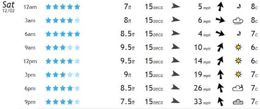
Saturday's forecast for Troon, in the Firth of Clyde, showed that the predicted gales were not expected to arrive until well into Saturday evening. The surf at Machrihanish was predicted to be 9.5 feet in advance of the arrival of the approaching Atlantic low pressure system. Tony and I decided to nip out to Lady Isle, which lies about 4km off Troon Point. However, rather than launch at Troon, we decided to take advantage of the southerly winds and swell and a flood tide and so launched a little further south than Troon....


...some 30km south to be precise! Nonetheless, we reckoned we could still be off the water by the back of 4pm, before the worst of the wind arrived!

Using a car or a ferry to get upwind before a downwind paddle may not be very environmentally friendly but it sure is a lot of fun! Tony's wife kindly dropped us off at the Swan Pond car park in Culzean Country Park and we trollied our kayaks down to Maidenhead Bay. Tony's dog, Bob, was extremely reluctant to be left behind and ran out onto the rocks of Barwhin Point, where he leapt onto Tony's rear deck as we passed by. Unfortunately he slid off the other side. It's just as well he likes a swim.

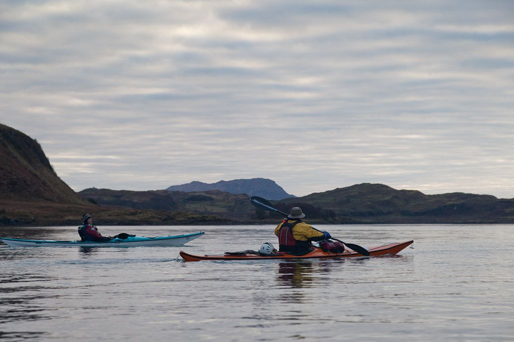
Leaving Barwhin Point and Turnberry lighthouse behind us, swell was already making its way up the Firth of Clyde.


 The sun soon broke through the morning cloud and mist and...

...by the time we stopped for first luncheon, at the north end of Culzean Bay, we were in full winter sun. Overheard, parallel streams of cirrus clouds in the jet stream predicted bad weather in 12-36 hours...

...so my Flat Earth sail was rigged and ready for some action!

Sunday, February 13, 2011

Sea kayaking round Luing.

 Circumnavigation of Luing: a 32km day trip from Ellenabeich, Seil, January 2011.


18.2 km/hr in the Cuan Sound, between Luing and Seil.

The tide times in the Cuan Sound and the Grey Dogs (also the Corryvreckan) are influenced by low pressure Atlantic systems and can be difficult to predict within an hour's accuracy. However, in a high pressure system they are much more predictable, though times vary between springs and neaps.

The north and west going flood begins +0430 HW Oban (-0100 HW Dover)  at 7 to 8 knots at springs and +0515 HW Oban (-0015 HW Dover) at neaps.

The south and east going ebb begins -0145 HW Oban (+0515 HW Dover) up to 8 knots at springs and -0100 HW Oban (+0600 HW Dover) at neaps.

The time changes by 6.5 minutes each day between springs and neaps. The constant between HW Dover and HW Oban does vary, so most accurate times are calculated by using HW Oban times (though not if you have calculated HW Oban indirectly from HW Dover!!).

On the day, HW Oban was at 0749 and 2011 and it was 1 day after springs so the time had drifted 6.5 minutes from the spring time. So the north and west going flood started about 0749 + 0436 = 1225 and the south and east going ebb started at 0749 - 0139 = 0610. We were on the water by 0955.


The Grey Dogs were salivating, while awaiting our arrival.


Ferry gliding in the Grey Dogs.


A sting in the tail of the Sound of Shuna.


Toberonochy, what's the story?


The stirring sound of moving water in the Cuan Sound.


Darkness stole across the Isles of the Sea.


Saturday, February 12, 2011

Darkness stole across the Isles of the Sea.

The entrance of the Cuan Sound can be a bit bouncy as the flood tide jets out into the Firth of Lorn...

... but it soon flattened off as paddled up the west coast of Seil.

The sun was setting in the SW as we approached the village of Ellenabeich.

As we drifted north with the now gentle tide we looked back to Scarba, Lunga, the Black Islands and the Garvellachs.

The sun dipped behind the Garvellachs and darkness stole across the Isles of the Sea. Our voyage amongst the islands and the tides that rush between them was over.

Friday, February 11, 2011

The stirring sound of moving water in the Cuan Sound.

It was now three hours after the start of the spring flood tide and our course took us in a dog leg, round the north end of Torsa and into the Cuan Sound. We had told Phil that there might be a little slope (several feet or so) but there would not be any whirlpools (Phil has an unaccountable aversion to whirlpools).

At the entrance of the Sound, the skerry of An Cleiteadh, constricts and dams the waters before they accelerate and turn through a right angle into the main body of the Sound. I knew that Phil had got suspicious, when he asked "What's that roaring noise?" Jim explained it was just a little stirring of the waters and described paddling down "the V" to him as we all slid down the slope. As I was paddling quite hard to get my sinking stern out of a big rotating hole in the water, I overheard Phil say to Jennifer, "He can't fool me, that's a ****ing whirlpool!*"

Then we shot through the body of the Sound.

I know the photos look a bit tame, I obviously didn't risk my camera on the bouncy, swirly bits but the GPS showed we hit 18.2km/hr...

...just to the north of An Cleiteadh rock!

There was some more excitement at the exit of the Sound and we took a slight detour to savour some little overfalls. Both Jim and I got our faces wet.

*swirling whirlpool!