Thursday, February 18, 2010

A first paddle in the Cetus LV


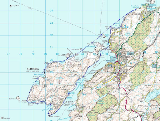
This was to be Jennifer's first paddle in the new P&H Cetus LV. We did not want to let her off lightly, so we chose a little 44km trip from Seil over the Firth of Lorn to Mull. We entered Loch Spelvie, portaged into freshwater Loch Uisge then portaged back into the sea again at Loch Buie.
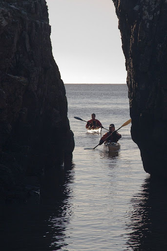
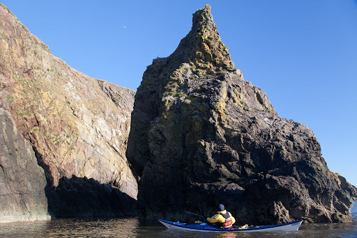
Here we are at the foot of the remote and bold cliffs of An Garradh, Mull at sunset. We still have a 16km open crossing of the Firth of Lorn before returning to our start point of the Isle of Seil.


Most of the crossing was done in complete darkness with a F3-4 wind at 45 degrees to our bows and an adverse current of 1 knot. In the darkness, we could only feel and taste the waves.

There are very few untried kayaks you would trust using for a trip like this. The Cetus LV proved to be one. Jennifer found it to be completely comfortable and its behaviour in the dark and in challenging conditions, to be completely predictable and confidence inspiring. Her only criticism was an over stiff skeg adjustment.

I hope I will be able to wrest it from her hands before we finish testing it for issue 20 of Ocean Paddler magazine.

A mysterious cleft at Gutcher's Isle


We left Balcarry Point and the expanse of Auchencairn Bay far behind as the flood tide...


...carried us eastward past the seaward cliffs of Hestan Island. The lighthouse is a recently built tardis design.


We then made swift progress across the mouth of Rough Firth and past Castlehill Point, where many oyster catchers were waiting for the tide to turn.


At high water, we entered a bay called Gutcher's Isle.


At the back of the bay there was a narrow cleft in the rocks, less than a paddle breadth wide. Where would it lead?

Wednesday, February 17, 2010

Mud, tides and windmills on the Solway


Back at the end of January, we drove south to Auchencairn Bay on the Solway Firth. We parked behind the hotel and trollied the kayaks down a delightful lane to the shore. In the distance, beyond the shoulder of Hestan island, our destination, the Colvend coast, lay tantalizingly on the far side of Auchencairn Bay .


Launching here is very much controlled by the tide. The window extends for about 2.5hrs either side of HW Hestan Island. If you arrive and see the mud is still exposed, don't even attempt to cross it, it is glutinous, evil smelling stuff that you will carry round with you for many weeks to come. Being the Solway, the tide will come in very quickly, so be patient and wait just a little until it is covered.


On launching, we first turned west along the cliffs of Balcarry Point. In the spring and early summer, these cliffs come alive with thousands of sea birds such as guillemots, razorbills and fulmars. Today...


...all was quiet as we explored the stacks at the base of the cliffs....


...before turning east to cross Auchencairn Bay. To the south, the windmills of the Riders Rigg wind farm were silhouetted against the distant snow covered mountains of the English Lake District.

Clearing fog, Ganavan Bay to Kerrera


A 29km day trip from Ganavan Bay round Kerrera, Firth of Lorn, January 2010.


Fog lifting in the Sound of Kerrera.

Ganavan, a launch site for sea kayaks and seaplanes

The fog on the Lorn...

Better Days: the wreck of the Hyacinth

Black and white in the Sound of Kerrera

Better Days in The Little Horseshoe Bay

Fleeting wraiths of fog in the Sound of Kerrera

Gylen castle and the Brooch of Lorn

Blowing the cobwebs away in the Firth of Lorn.

The strange case of the missing calves at sunset.

The liquid canvas of the sea.

Embers of a Kerrera day


Photo album map.

Tuesday, February 16, 2010

A tour of the Clyde Lochs and rocks


A tour of the Clyde lochs and rocks from Lunderston Bay, Firth of Clyde, 30km, January 2010.


The Cloch lighthouse.

Two iconic, but ultimately impotent, towers on the Clyde

Keeping an eye open for ferries at Gourock

Little and Large on the Clyde: Ocean terminal and Kilcreggan pier

A warm glow in a wintery Loch Long

The number 475 bus and an occasional sea kayaker

A nice shade of grey, in Hunter's Quay

Dunoon, and her unused new pier

The Gantock Rocks

Passing ships in the night.


Photo album map.

Arran West Coast to Carradale


A day trip from Dougarie on the west coast of Arran to Carradale on the Kintyre peninsula, Firth of Clyde, 25km, January 2010.


A distant Ayrshire coast and Ailsa Craig from near Carradale.

An early morning wardrobe malfunction.

"Bru'd in Carradale from girders"

Torrisdale Bay in the Kilbrannan Sound.

Time to go in the Carradale Water

Return to Dougarie


Photo album map.

Seakayakphoto.com trip index 2010

2010 running total distance: 1235km

Ayr to Dunure, Firth of Clyde, 20km
Arran west coast to Carradale, Firth of Clyde, 25km
A tour of the Clyde lochs and rocks from Lunderston Bay, Firth of Clyde, 30km
Ganavan Bay to Kerrera, Firth of Lorn, 29km
Auchencairn Bay to Needle's Eye, Solway Firth, 21km
Ballantrae to Portandea, Firth of Clyde, 19km
Port Appin to Loch Creran, Firth of Lorn, 33km
Seil to Laggan Deer Forest, Mull, Firth of Lorn, 44km
Portpatrick to the Mull of Logan, North Channel, 33km
The Mull of Oa, Islay, Inner Hebrides, 26km
Holy Island from Brodick, Firth of Clyde, 20km
Loch Feochan to Loch Etive, Firth of Lorn, 36km
Ailsa Craig from Lendalfoot, Firth of Clyde 32km
Loch Fyne, St Catherines to Otter Ferry, Firth of Clyde 36km
Loch Fyne, Portavadie to Otter Ferry, Firth of Clyde 21km
Circumnavigation of Morvern, Firth of Lorn to Loch Sunart 115km
North Islay and west Jura, Inner Hebrides 82km
Islands of Fleet and Kirkandrews Bay Solway Firth 14km
Heads of Ayr from Seafield, Firth of Clyde 14km
Lunga and Scarba from Crinan, Sound of Jura, 47km
Fleet Bay, Solway Firth 21km
Rhinns of Islay, Inner Hebrides 47km
Mull of Oa, Islay, Inner Hebrides 44km
Sound of Islay 15km
Fleet Bay Solway Firth 39km
Gigha and Cara 46km
The Garvellachs from Seil, Firth of Lorn 32km
Cumbraes and Bute from Largs, Firth of Clyde 34km
Fleet Bay, Solway Firth 11km
Kirkcudbright from Fleet Bay, Solway Firth 43km
Fleet Bay, Solway Firth 5.5km
Portavadie to Colintraive via the Kyles of Bute, Firth of Clyde 33km
Derwent water, Lake District, England 11km
Arran from Portencross, Firth of Clyde 31km
Loch Long to Loch Goil, Firth of Clyde 25km
Loch Eil to Loch Linnhe, Firth of Lorn 30km
The Cumbraes from Largs, Firth of Clyde 25km
Seafield to Maidens, Firth of Clyde 21km
Arran from Portencross 2, Firth of Clyde 31km
Glasgow Green to Port Glasgow, Firth of Clyde 33km