Friday, February 05, 2010

Better Days in The Little Horseshoe Bay


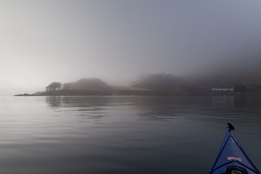
In a break in the fog, we saw a row of neat little white washed cottages at the back of the perfect crescent of The Little Horseshoe Bay.


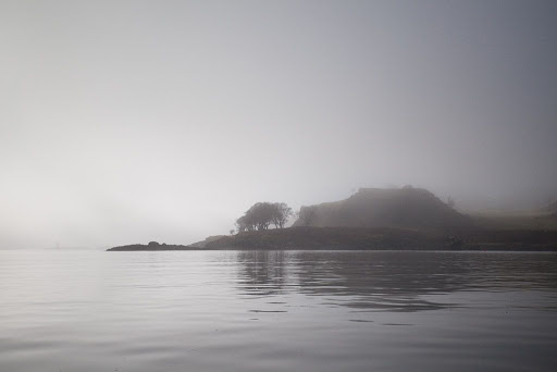
As we approached, it was obvious that this bay had been settled for a very long time. The grassy hillock at the entrance to the bay has a flat top which betrays it as an Iron Age hill fort.


The cottages were originally built for slate workers who worked at quarries at the south of the island. When the quarries failed a lobster industry became established here and the workers boxed lobsters for delivery to London and Southampton by train. Orders were delivered by telegraph and telegram boys from Oban Post Office. The business boomed to such an extent that Kerrera was the first Scottish island to get a telephone line installed! Today the only sign of activity was a sole oystercatcher which kept an eye on us from the safety of the beach.


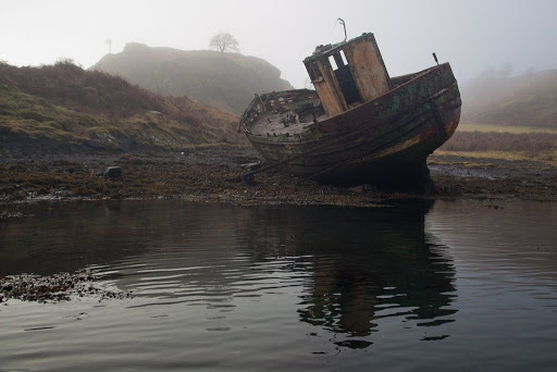
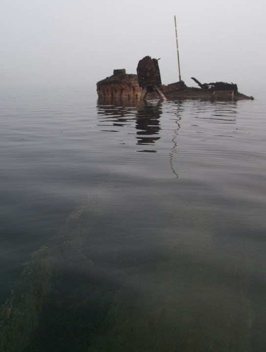
Hidden away in a corner of the bay lay this sad old fishing boat. Her paint had all but peeled from her grey timbers. I could not even make out the name, under which she was once sailed with pride. Even her iron rubbing strakes had sprung free of their fastenings and come to rest at an angle on the shore, as if in a forlorn attempt to keep her upright.

Sadly, she has seen better days. Just like the boats of the Iron Age settlers before her, one day she will be gone, without a trace.

Thursday, February 04, 2010

Black and white in the Sound of Kerrera


From Aradantrive Bay we paddled down the Sound of Kerrera to Heather Island. The fog seemed to suck all colour from the land and sea-scapes.


There was no wind to disperse the fog and glassy calm conditions reflected the sun, which occasionally broke through a thinner layer.


On the mainland side of the Sound, the Ardbhan Craigs rose into the mist. These steep cliffs with a raised beach at their foot were cut when the sea level was higher.


We arrived at Kerrera's jetty where the ferry, the MV Isle of Kerrera , was tied up. She is powered by two 75hp Honda outboards. The ferryman, Duncan McEachan, will go over to the mainland if an intending passenger turns a white board so that its black side faces Kerrera.

Wednesday, February 03, 2010

Better Days: the wreck of the Hyacinth


The Mull ferry's foghorn reverberated backwards and forwards between the unseen cliffs that back the Sound of Kerrera. At Ardantrive Bay we came across the sad remains of Hyacinth that was wrecked on the rocks after catching fire on the 28th April 1920. She was an iron motor drifter under the command of Captain Buchan. She was built in 1901 and was 21m x 6m with a gross weight of 39 tons.


Under the clear water we could still make out the lines of her barnacle encrusted keel and bulwarks and then, as we drifted in the ebb tide, she was lost in the fog.

Tuesday, February 02, 2010

The fog on the Lorn...


As we left Ganavan, fingers of cold, grey fog curled round us...


... like a shroud...


... distorting distance and muffling even the sound of the Mull ferry's fog horn.


Even the solid outline of Dunollie castle was softened to little more than an ethereal shadow emerging from the trees above the shore. Although there has been a fortified site here since the seventh century, the current fortifications date from the 1200's to the 1400's. The castle was the seat of the Lords of Lorn, the MacDougalls.


We followed the coast to the Dunollie lighthouse at the entrance to Oban bay. The light was established in 1892 and flashes twice every 6 seconds. There are white, red and green sectors. The lighthouse marks the narrowest part of the channel between the mainland and our destination, the island of Kerrera. The channel is only 200m wide but we could not see the far side. The Mull ferry has to navigate this channel and it was imperative that we should not impede it. We listened carefully to its foghorn. We decided that it was still a little way off and so we crossed quickly to Kerrera. We almost collided with its rocks before we saw them looming out of the fog. Behind us, the ship's tannoy advised drivers to return to the car deck for disembarkation.

Monday, February 01, 2010

Ganavan, a launch site for sea kayaks and seaplanes


On Saturday 23rd January, a high pressure area sat across Scotland. As we drove north towards Oban, the forecast was for coastal fog. We took a detour over to Arrochar at the head of Loch Long and since there was no fog we decided to press on.


At Connel bridge over the tidal narrows of Loch Etive, the fog was firmly down. The Falls of Lora were not in evidence because it was the last hour of the flood.


At Ganavan Sands, to the NE of Oban, the fog rolled in just as we were launching. We could hear the booming of the MV Isle of Mull's foghorn as she made her unseen approach to Oban from Craignure on Mull. Our plan to nip across to Mull for the day would need to wait!

Ganavan is a very convenient launch site near Oban. Car parking is free in the winter but there are often pay and display meters. There is a public convenience with water at the back of the car park. The very wide slip way betrays Ganavan's past. In WW2 it was the maintenance base for No. 209 Squadron RAF. The squadron moved to Oban in 1939 and flew antisubmarine missions over the North Atlantic shipping lanes. From 1940 they used troublesome Saunders Roe Lerwick aircraft but changed to PYB Catalinas in 1941.

There would have been no danger of a flying boat landing on us today. They would be grounded. Actually, although the Catalinas are long gone, Oban does have a current seaplane service to and from Glasgow.

Wednesday, January 27, 2010

Passing ships in the night.


From the Gantock Rocks we had to cross the main shipping channel in the Clyde on our return to Lunderston. To the south of us, the steady white flash of the Cowal mid channel marker showed us the area of highest risk. We put our head torches on and paddled at a steady 8km/hr across the 2.8km to the Lunderston shore.


The sun had set some time ago and the cold air gripped us as we made our way over the snow covered sands to the car park.


The dying embers of the day still glowed round the smokeless chimney of Inverkip powerstation. Its height and bright red aircraft warning lights make it the best marine navigation beacon on the Clyde. I will be very sorry when it is demolished to make way for a housing estate.


Just as we were wrapping up, the very business like offshore tug/supply vessel, MV Kingdom of Fife made her way down the channel at 10.5 knots. She was built in 2008 by Damen Shipyards of the Netherlands. She is 61.20m long by 13.50m beam and a gross tonnage of 1459.00t. We were quite glad to have cleared the channel before her arrival.


Altogether we had covered 30km on a lovely circular route in the Clyde. It proved a very variable route with lots of interest and the contrast between the docks at Greenock and the glaciated mountain confines of Loch Long was quite dramatic. Once again I am grateful to Jim and to Phil who lifted and laid both my kayak and myself.