Wednesday, January 27, 2010

Passing ships in the night.


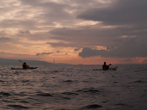
From the Gantock Rocks we had to cross the main shipping channel in the Clyde on our return to Lunderston. To the south of us, the steady white flash of the Cowal mid channel marker showed us the area of highest risk. We put our head torches on and paddled at a steady 8km/hr across the 2.8km to the Lunderston shore.


The sun had set some time ago and the cold air gripped us as we made our way over the snow covered sands to the car park.


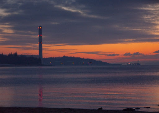
The dying embers of the day still glowed round the smokeless chimney of Inverkip powerstation. Its height and bright red aircraft warning lights make it the best marine navigation beacon on the Clyde. I will be very sorry when it is demolished to make way for a housing estate.


Just as we were wrapping up, the very business like offshore tug/supply vessel, MV Kingdom of Fife made her way down the channel at 10.5 knots. She was built in 2008 by Damen Shipyards of the Netherlands. She is 61.20m long by 13.50m beam and a gross tonnage of 1459.00t. We were quite glad to have cleared the channel before her arrival.


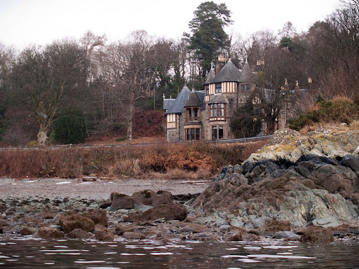
Altogether we had covered 30km on a lovely circular route in the Clyde. It proved a very variable route with lots of interest and the contrast between the docks at Greenock and the glaciated mountain confines of Loch Long was quite dramatic. Once again I am grateful to Jim and to Phil who lifted and laid both my kayak and myself.

Monday, January 25, 2010

A final voyage.


Today was my father, Rae's funeral. I don't usually post very personal things and I wasn't going to mention this significant event in my life. However, it was my Dad who introduced me to the sea when I was four and who over the years guided me to safely navigate her waters, so it seems only appropriate to acknowledge his influence on this important part of my life. Of course his influence extended to all parts of my life, I am what I am because my father and my mother.


As my Dad's life slipped away, after a long and distressing illness, I was fortunate to be able to spend the last few days with him. We reminisced about past voyages together and I showed him photos of my recent voyages. We talked about his impending final voyage. He told me he was not afraid of dying and that he had no regrets. I was proud to be his son and now I miss him terribly.

Be a good parent and share your voyages with your children.

Sunday, January 17, 2010

The Gantock Rocks


From Dunoon Pier we paddled SSE for 600m and came to the Gantock Rocks.


This dangerous reef has claimed many vessels over the years. In 1977 the PS Waverly grounded on them but fortunately she got free. In 1956 the MV Akka, a Sweedish 135m long ore carrier, struck the rocks when her steering geer failed. She sank very quickly in about 3-4 minutes Three crew went down with her, 3 crew died in hospital later but amazingly 27 people were rescued.


In 1829 Robert Stevenson produced a design for a beacon to be erected on the Gantocks. But it was not built until 1886.


It flashes a red light every six seconds. Below the murky waters of the Clyde, the light is unseen by the many wrecks, which litter the sea bed round the Gantocks.

Saturday, January 16, 2010

Dunoon, and her unused new pier


From Hunter's Quay we proceeded down the coast of the Cowal peninsula towards Dunoon. The view to the south was superb with distant views to Ayrshire, the two giant cranes of the Hunterston Ore Terminal, Great Cumbrae, Little Cumbrae, the distant pyramid of Holy Island just left of the Gantocks rocks light beacon, then Bute and finally the Cowal shore.


As we approached Dunoon, the ferry from Gourock, MV Saturn was edging in to dock at Dunoon pier.


MV Saturn is one of the oldest ferries in the Calmac fleet she was built in 1978 at the now defunct Ailsa Yard at Troon further down the Clyde. She is the winter relief vessel for the similar MV Jupiter, which normally operates the service. Neither Saturn nor Jupiter have true RORO car deck as they load and unload from the side and stern.


Dunoon probably means green fort and right behind the pier you can see the flat topped grass covered mound that was typical of motte and bailey castles. Dunoon Castle was established in the 1100's and finally abandoned in the 1650's.


We paddled along Dunoon's Victorian pier after Saturn had left on her voyage back to Gourock. The pier was built in 1835 but extensively modified in 1895. The side loading ferries, Jupiter and Saturn still berth here despite a new modern jetty and linkspan for RORO ferries having being built alongside in 2005. Under EU competition rules, companies had to bid to run a service from the new jetty. Neither the government owned CalMac nor the locally owned Western Ferries chose to bid. So the new jetty lies unused!

Friday, January 15, 2010

A nice shade of grey, in Hunter's Quay


We crossed the Holy Loch and arrived at Hunter's Quay just after MV Sound of Sanda had landed and was offloading her cars. We quickly made our way round her stern (that would become her bow) and found ourselves paddling below more fine Victorian villas. Hunter's Quay was established in 1816 when James Hunter bought the local Hafton Estate. He built a quay in 1828 and extended it to a pier in 1858, as other people moved into the village and built villas there. The last steamer called at the pier in 1964. Then in 1973, Western Ferries bought the pier and opened up the frequent sailings to McInroy's Point at Gourock.


On the beach below a large villa we came across "The Jim Crow". The rock has been painted like this for more than a hundred years but during the night of 21st June 2009, it was painted over all in grey. This caused much local debate and was reported in the Dunoon Observer. Some people think the rock just looks like a crow. Other people think that the name refers to the "Jim Crow laws" that segregated black and white people in the USA from 1876 till 1965.

As you can see, The Jim Crow has since been restored. I don't know what American servicemen from the Holy Loch thought of it. Maybe it is just a crow but it's not a very attractive crow. Just because something has been there a long time does not make it right. Neither does the fact that many may not appreciate its significance to others. I certainly am not one for overzealous political correctness (I call things black and white boards, not chalk and pen boards) but in this case, I think the rock, and Hunter's Quay, would look better if it were a nice shade of grey.

Thursday, January 14, 2010

The number 475 bus and an occasional sea kayaker


From Loch Long we rounded Strone Point and entered the Holy Loch.


We stopped briefly on the beach below the Strone Inn. Smoke was rising lazily from its chimney, hinting at the warmth within. We were so cold that we would have loved to stop for a sample of its hospitality but we knew we had to press on.


We watched as the sun slowly set over the Holy Loch. The Holy loch is 4km long and about 1.2km wide. Most people remember the Holy Loch for the US Polaris submarine base, which was stationed here between 1961 and 1992. There was a huge floating dock with attendant ships moored right in the middle of the loch. In 1969, I remember the excitement when (as members of Troon Sailing Club) we were invited for a tour of the facility. Hamish Gow (who with his wife Anne were the first sea kayakers to reach St Kilda in 1965) was arrested in the early 1960's, after paddling out to a US Polaris supply boat and attempting to climb its heavily greased anchor chain as part of a CND protest. It is no wonder that if a sea kayak is seen anywhere near the UK nuclear submarine base at nearby Faslane on the Gare Loch , a Navy launch will escort it off the premises.!

Today, apart from ourselves and some sunbeams, the Holy Loch was empty.


We launched again and paddled out past Strone pier and into into the loch. It's not only the submarines that have left, the steamers that once brought life to Strone and the Holy Loch are long gone too. Now only the number 475 bus and an occasional sea kayaker stops at Strone Pier.

Wednesday, January 13, 2010

A warm glow in a wintery Loch Long


From Kilcreggan on the Rosneath peninsula we proceeded west to Baron's Point. Here we turned to the north and entered Loch Long. Loch Long is indeed long it stretches north from here, in a narrow fjord like ribbon, for 26km. For most of its length it is between about 50m and 95m deep. Its head at Arrochar is 130km from the mouth of the Firth of Clyde. All the lochs at the head of the Firth have been gouged out by glaciers during the Ice Age.


Just turning a corner revealed mountain scenery, which was a complete contrast to the industrial landscape we had just left. Low, snow carrying clouds hung over the mountains and flurries of snow threatened to turn into a full snow storm at any moment. It was very cold.


Past the delightful village of Cove, we came to the 4* Knockderry House Hotel. This hotel is sea kayak friendly and is a regular haunt of Pam and her friends. The hotel staff seemed to be expecting us because, on our approach, a piper emerged onto the snow covered grounds of the hotel and started to play the first of several tunes. The skirl of the pipes echoing round the snow covered mountains was a truly magnificent experience, to which we added a dram of single malt Scotch whisky...


Unfortunately we had no time to partake of luncheon and refreshments in this lovely establishment's hallowed halls or comfort ourselves next to the warm glow of its fire. The sun was already dipping to the horizon. So after a quick flask of soup, washed down with a 12 year old GlenLivet, a Bruichladdich 3D and a 10 year old Springbank, we continued on our way.


Refreshed but frozen, despite the warm glow in both our stomachs and the sky, we crossed to the far side of Loch Long.


Our destination was Strone Point behind which lay the Holy Loch.