Thursday, September 24, 2009

The great caves of Bagh an Da Dhoruis, Islay


At the top of the existing beach at Bagh an Da Dhoruis there is a raised beach with a long dry marine cave system. It was probably 10,000 years ago that the sea last surged through these subterranean channels.


We were staggered by the scale of the place as we soon lost sight of each other...


..in the maze of interconnecting caverns. In some, prehistoric shell mounds reveal the eating habits of our ancestors.


Unfortunately for our further exploration, the sun was now dipping fast to the western horizon. We still had an open crossing of 11km to reach our destination. We returned to the shore through yet another cave system on this incredible north shore of Islay.

Wednesday, September 23, 2009

Just a couple of doors away, on Islay.


From Ruvall we paddled west along the remote north coast of Islay.


The cliffs became considerably higher...


...as we approached Bagh an Da Dhoruis (Bay of the Two Doors).


The only footprints on the sands of this huge beach were our own.


The islands of Oronsay and Colonsay could just be seen, far on the northern horizon.


We made our way to the back of the beach...


...where we had spotted what looked like a "door" through the cliffs.

Tuesday, September 22, 2009

Navigation and spice in the Sound of Islay.


Proceeding up the Sound of Islay we soon came across yet another distillery. What a wondrous isle Islay is! Sea kayak navigation is so easy here. Even we (without a single navigation qualification between us) knew we had arrived at Bunnahabhain. There has been a distillery here since 1881. The fine malt whisky produced here is lighter and less peaty than the whiskies produced by distilleries elsewhere on Islay. This is because the water rises from a limestone spring and is piped directly to the distillery, without gathering peat in surface rivers and lochs. The 18 year old bottling has been described as follows: "The voyage ends with dry notes that are interspersed with mixed spices fading magnificently into a light salt and sherry finale."

Despite its spicy name and overtones, I do not think this whisky distillery has Indian owners.


Bunnahabhain marks the end of the road and we now paddled past one of the wildest and most remote corners of Islay.


To the east, the modesty of the heaving Paps of Jura was covered by a decent layer of cloud.


Our destination was Ruvall lighthouse which is perched on the end of Rubh a' Mhail. An electricity supply was put in to the lighthouse in 1981. The poles and cables were flown in by helicopter but the pilot had a lucky escape when his rotor hit one of the poles that had already been erected.


A basalt dyke runs through the headland to the north of the lighthouse. Its continuation can be seen on the other side of the Sound of Islay, marching up the hillside of the Paps.


The lighthouse was built in 1859 by David and Thomas Stephenson. The tower is 34m high. Every 15 seconds there are 3 quick flashes. The light is white with the exception of the NW quadrant which is red. The lighthouse has been automated since 1983.

Rounding the point, we now left the Sound of Islay and headed west along the most remote part of Islay's incredibly varied coastline.

What would we find next?

Monday, September 21, 2009

Better Days in the Sound of Islay!


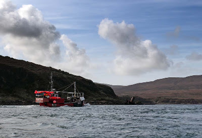
We thought we were super fit kayakers, flying along as the coast of Islay slipped astern at 14km/hr. It was only when the lobster boat Calon Mor zipped past us that we realised that the tide was doing almost all the work. PE91, Calon Mor was built in Poole in 1983. She is a wooden boat 11.8m long and she used to have a forward wheelhouse when used as a trawler in England then Wales. She is currently owned by Kenneth Woodrow from Bruichladdich, Islay.

Then, beyond the shipshape Calon Mor, we noticed something lying at an odd angle on the shore of Rubha a'Mhill, just south of Bunnahabhain.


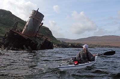
It was the wreck of the 328 ton Fleetwood trawler Wyre Majestic. On the night of October the 18th 1974 she was steaming in the company of her sister ship the Wyre Defence to Fleetwood. There was no berth to offload their fish at Oban and they were obviously in a hurry to get their catch to a market.


She was making 10 knots and with a spring tide of 8 knots, she hit the rocks at a combined speed of 18 knots. Fortunately there was no loss of life. At the time of the collision her skipper was below decks and her bosun who was at the wheel admitted he was under the influence of drink. Her skipper and two crew stayed aboard for 10 days, until the next spring tides, in an attempt to refloat her. She stayed firmly stuck on the rocks despite attempts by her sister ship, a tug and the Port Askaig lifeboat to tow her off.
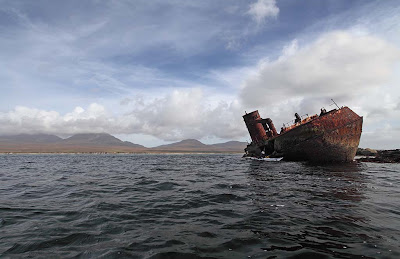

Her bow and bridge have now broken away, leaving only the sad and rusting remains of her stern and midships. She serves as a warning to all mariners to treat the Sound of Islay with the greatest of respect.

An interesting footnote is that the Wyre Majestic was built by Cochranes of Selby in Yorkshire, the same yard, which built the main Islay ferry, the MV Hebridean Isles.

Sunday, September 20, 2009

Caol Isla: whisky, puffers and paps!


Leaving Port Askaig, the flood tide was racing north up the Sound of Islay at 16km/hr so there was really little choice involved in deciding where to go. Just round the corner from Port Askaig, the NW wind proved to be one of the sweetest winds on the west coast. It was carrying the "Angels' Share" over the water from the Caol Ila distillery. The name means Kyles of Islay (or Narrows of Islay).

The distillery was founded in 1846. From the 1920's until 1972 the distillery was served by its own puffer service, the first, Pibroch was built in 1922, her successor, also called Pibroch, was built in 1957. They sailed from the distillery pier to Glasgow via the Mull of Kintyre. The distillery was expanded and rebuilt in 1974 but now barley comes in and whisky goes out via lorries and the Calmac ferry.


From out in the Sound of Islay we caught sight of the Rhuvaal lighthouse, still some 9km distant.


Although the water of the Sound was calm, we were still proceeding at 14km/hr with little paddling effort.


The summits of the Paps of Jura were decently wreathed in puffs of light cloud.

Saturday, September 19, 2009

Return to Islay


It had been too long since our kayaks had explored the waters of the magnificent isle of Islay in the Inner Hebrides. We found ourselves waiting to board MV Hebridean Isles at Kennacraig on the Kintyre peninsula.


Our excitement was palpable as the ferry crossed the broad Sound of Jura and approached the narrow Sound of Islay. The latter separates Islay to the south from Jura to the north. Islay is an incredibly beautiful island and has two really excellent blogs devoted to island life: IslayBlog and Islay Weblog.


We unloaded our kayaks at Port Askaig on the Islay side of the Sound of Islay. Port Askaig is a tiny inlet, sheltered from the strong tides of the Sound. We got ourselves ready at the slipway which leads into the little inner harbour where the local lobster boats were berthed.


It is always a pleasure watching the ferries break in and out of the tide, as they berth at their jetties. However, we wasted no time and were on the water before the Hebridean Isles disappeared back to Kennacraig.

Where would we get to this time?

Tuesday, September 08, 2009

Where east meets west.


The Kyles of Bute, which seperate the Cowal peninsula from the Island of Bute in the Firth of Clyde, are one of my favourite places to paddle. Although far from the open sea and in a sheltered location, strong tides swirl round the Kyles creating interest. For those kayakers who have yet to experience moving water, this is a great location. At the Burnt Isles the tides sweep through at up to 5 knots. The west going stream starts about -0220 HW Greenock and the east going stream about +0440 HW Greenock.


This is looking down the East Kyle with the Ayrshire coast in the distance. The Burnt Isles are in the narrows and just beyond you can see the Bute ferry on the right just about to depart for Colintraive on the Mainland.


This is looking up the West Kyles from Tignabruaich. Despite the proximity to the mountains, palm trees flourish due to the shelter from the wind and the mild sea water which is warmed from the Gulf Stream.