Sunday, June 07, 2009

A Solway sunset swim


After my visit to the stack and caves, I returned to the little beach below Meggerland Point. As I my way through the skerries, I floated over cobbles, which shimmered in the ripples of the crystal clear water.


I couldn't resist a second swim in this beautiful spot, as the sun sank gently to the west.

31/05/2009 pm

Saturday, June 06, 2009

Kayak Caledonia progress report #10


Day 16, 6th June 24km

21:30 Tony: "We are in Rockfield at the mouth of the Moray Firth. We didn't launch till 2:30 by which time the sea and the wind had settled. We used the morning to wash and dry all our stuff in the campsite laundry. The Fourth Element Thermocline stuff has proved really good. It was a long grey crossing direct to Tarbart Ness from Brora. The wind had dropped to force three but it was still very cold.

Once round the Ness, into the Moray Firth, we could see snow on the Cairngorms. Its a very rocky coast but we landed at the jetty in Rockfield. A man was sitting in his garden and suggested we camp on his lawn! We are just back from visiting the pub in Portmahomack. We didn't stay long as a bunch of young locals seemed intent on a swally race. We thought discretion was best and made our exit.

Tomorrow we hope to get round Chanonry point and camp at Fortrose."

The caves and stacks of Meggerland Point


I was pretty hot and bothered after climbing all over Castle Haven so I went for a refreshing swim in a tiny cove below Meggerland Point. I then continued east below the heughs (Galloway for cliffs). Rounding a corner I nearly missed a cave in the shadows cast by the setting sun.


I am glad I didn't because it is one of the best caves in these parts. There was some deep gurgling going on in the back of the cave...


...which was punctuated by a steady drip from somewhere in the darkness above me.


Continuing eastwards I threaded my way behind Meikle Pinnacle, an isolated stack.


I then came across Dove cave which can only be entered at HW springs. I just love the old man, a mimetolith which stands watch over the entrance.


The ebb was now well established and I was 8km from home so...


...I retraced my route in the shade of Meikle Pinnacle before emerging into the light of the setting sun.

31/09/2009 pm

Friday, June 05, 2009

The most southerly broch; Castle Haven


Last weekend it was neap tides on the Solway. HW here is always in early morning and evening with neaps and as the tide goes out a long way, mid day paddling is not possible from many of the bays.

I set off at 5pm on Sunday evening and crossed the mouth of Fleet Bay. I turned into Castle Haven Bay as I know of a wonderful historic site at its head. Castle Haven is passed by by most people. Its wall grow out of the Galloway rocks but have become overgrown by vegetation. It is a D shaped broch or dun. These double walled dry stone structures were built up the west coast of Scotland and the Hebrides in the final centuries BC. Castle Haven is the most southerly example.


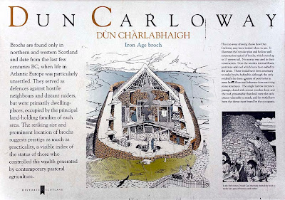
Dun Carloway in Lewis is perhaps the most famous. As the sea was the highway of communication in those days it is likely that the owners of Castle Haven and Dun Carloway knew each other even though they are 420km apart as the sea eagle flies. Perhaps they were even on first name terms!


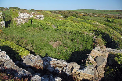
The typical doubled wall structure of a broch is seen from the SWE corner...


... and more clearly in this aerial view from the scran website.


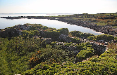
Most brochs are circular but Castle Haven's west wall is straight as it follows a low line of cliffs, which drop to the bay below. The resulting enclosure is D shaped.


The quality of the interlocking stone masonry has survived two millenia. Unfortunately most of the upper structure has been raided to build some of the many 18th and 19th century drystone walls which criss-cross the Galloway countryside.


After a very pleasant exploration of this fascinating structure I made my way back down the stone steps to the sea gate and the bay below.


White campion flowers adorned the rocks below the castle walls. I returned to my kayak and paddled on in the evening sunshine.

31/05/2009 pm

Kayak Caledonia progress #9


Day 15, 5th June 36km

17:30 Tony: " We are in Brora. We had big squalls coming over today and were up at 0530 to beat the wind. We got on the water at 0730 when it was still only 4 degrees. The coastline here is really lovely with stacks and cliffs covered with birdlife. The NE wind picked up to about a six as we were passing Helmsdale so we didn't land. The Quest is handling the following seas really well. We had a surf landing on Brora Beach. We carried our gear over the golf course to the campsite and had a hot shower, glorious! We will walk into Brora for something to eat later. It's to be windy overnight and tomorrow am, so we will probably have a late start and head to Embo before cutting across the Dornoch Firth to Tarbert Ness. Not quite sure where we will stop. It's probably a bit far to the Black Isle."

Thursday, June 04, 2009

Kayak Caledonia progress report #8


Day 14, 4th June 47km

21:28 Tony:
"We are in Dunbeath. I thought the east coast would be downhill all the way but we hit some of the roughest water yet between Noss Head and Sarclet Head. The tide was against us and with the NE wind it was wind against tide all the way. Unfortunately we could not get in really close to all the caves geos and stacks. Once round Sarclet we were in the lee of the cliffs so it was a good bit easier and proved to be a most interesting stretch with great rock architecture. We climbed up the hill behind Dunbeath beach and staggered to the hotel, but it was shut. That was the low point of the trip. We walked up the A9 and fortunately found a pub.

At our last stop, yesterday evening, the pub proved to be a Grade 5 experience. It was really noisy but fell silent when we walked in and all eyes were on us. After 14 days we smell pretty bad but we sure sweetened the air in that place, it was the baddest smelling pub in all Scotland. After a while the noise started again as they all started talking about us. They spoke a different language, composed entirely of four letter, one syllable words. After a quick drink, we left the public bar to the locals and went into the lounge bar for something to eat. If anything it smelled even worse. I have no idea what it was we ate. We were glad to escape to the tents.

Given the force 7 forecast for tomorrow pm, we will get going about 5am and hopefully get down to Golspie before the wind hits us. The heavy rain will hopefully cleanse le eau de Keiss out our pores."

The three pillars of Knockbrex


On Sunday I set off at 06:30am and paddled round the Islands of Fleet before heading towards the Carrick Coast of Galloway near Knockbrex. I came across three mysterious pillars. On further investigation I discovered they led to a hidden channel in the rocks.


Round a bend at the head of this channel lay a secret harbour. It was probably built for a yacht owned by the residents of nearby Knockbrex house.


A splendid morning paddle of 12km.

31/05/2009 am